

Journal list menu

 Issue
IssueHydrological Processes: Volume 35, Issue 8
August 2021
Export Citations
Download PDFs
ISSUE INFORMATION
CANADIAN GEOPHYSICAL UNION 2020
Simulating preferential flow and snowmelt partitioning in seasonally frozen hillslopes
- First Published: 22 June 2021
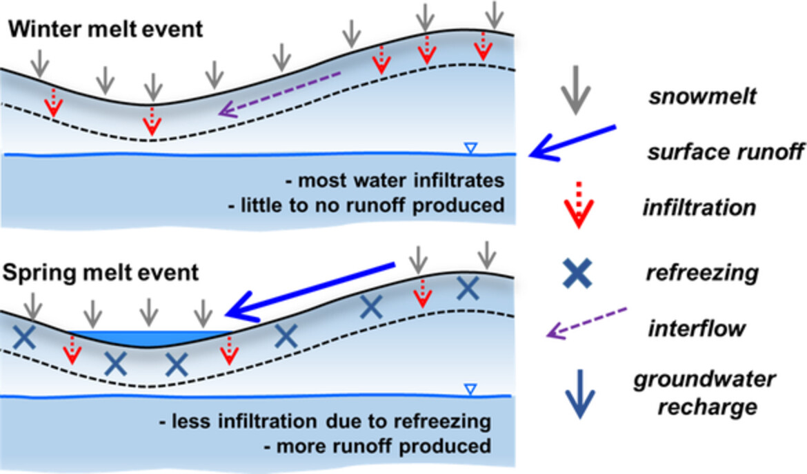
A dual-permeability description of water flow in frozen soils was integrated into the fully-integrated hydrological model HydroGeoSphere, and used to understand the effects of preferential flow and freeze-thaw on snowmelt partitioning in seasonally frozen hillslopes.
Evaporation from boreal reservoirs: A comparison between eddy covariance observations and estimates relying on limited data
- First Published: 04 August 2021
Using eddy covariance observations as reference, six evaporation models, categorized as empirical, combined and mass transfer, are tested on two boreal hydropower reservoirs of contrasting morphometry, while considering the scarce data context in which these reservoirs are typically managed. The Bulk transfer model with a constant Dalton coefficient of 1.2 × 10⁻³ worked best for estimating evaporation, especially if water surface temperature is available.
RESEARCH AND OBSERVATORY CATCHMENTS: THE LEGACY AND THE FUTURE
A catchment water balance assessment of an abrupt shift in evapotranspiration at the Hubbard Brook Experimental Forest, New Hampshire, USA
- First Published: 01 July 2021
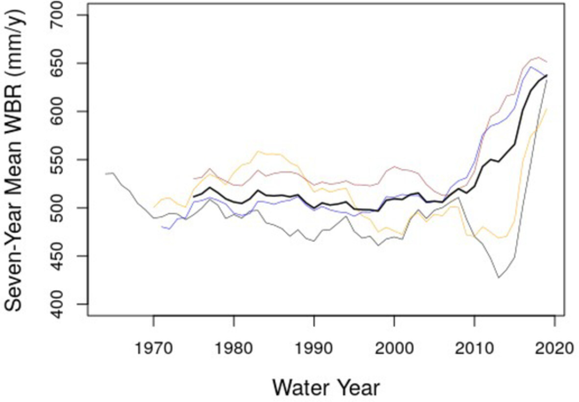
Water budgets in four reference catchments at the Hubbard Brook Experimental Forest have indicated an approximately 30% increase in the evapotranspiration (ET) as estimated by the difference between precipitation (P) and runoff (RO). This unprecedented change started in 2010 and continued through 2020. While we cannot fully explain what drove this increase, our analysis shows increases in the growing season potential ET play a role, driven partly by increasing atmospheric demand and partly by increasing leaf area index.
Long-term ecosystem monitoring at Huntington Forest: Integrating hydrology, biogeochemistry and climatic controls on watershed processes
- First Published: 29 July 2021
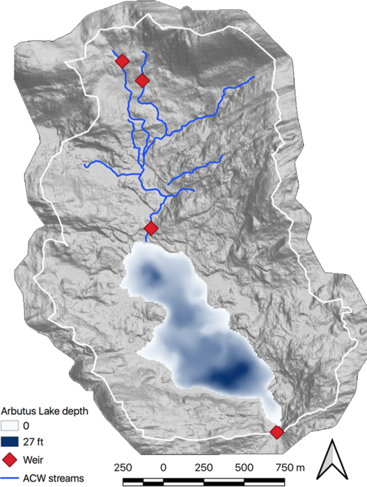
Arbutus Lake and Archer Creek Watershed, at Huntington Wildlife Forest in the Adirondack Mountains region of northern New York State (USA). Map depicts watershed topography, lake bathymetry, and stream and weir locations used for intensive long-term ecosystem monitoring.
Detailed streamflow data for understanding hydrologic responses in the Logan River Observatory
- First Published: 19 June 2021
Experimental catchments in the Pampa biome: Database on hydrology in grasslands and eucalyptus plantations in subtropical Brazil
- First Published: 26 June 2021
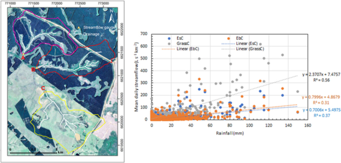
Rainfall, discharge, and turbidity data, collected since 2011, are presented for three small (≤ 1.1 km2) paired experimental catchments in the Brazilian Pampa biome, two covered with eucalyptus plantations and one with livestock-grazing degraded grassland.
Streamflow generation in semi-arid, glacier-covered, montane catchments in the upper Shule River, Qilian Mountains, northeastern Tibetan plateau
- First Published: 22 June 2021
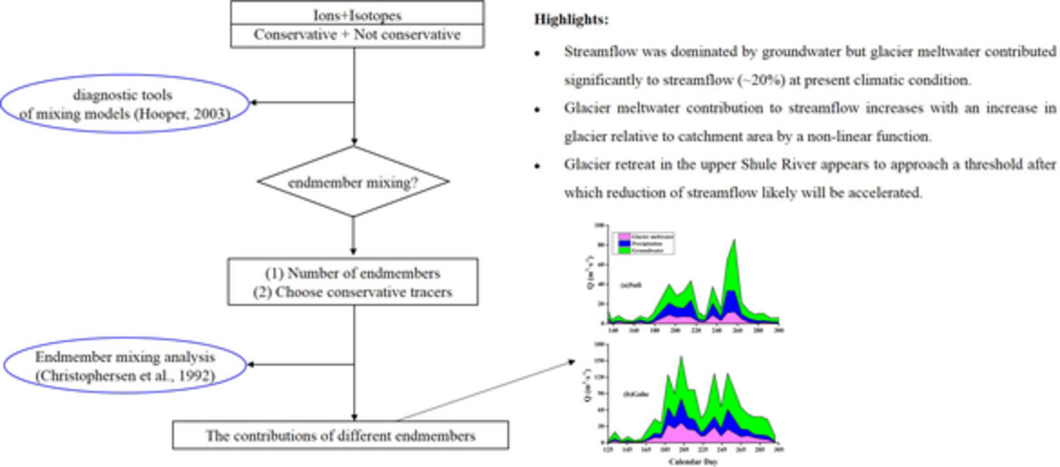
Streamflow was dominated by groundwater but glacier meltwater contributed significantly to streamflow (~20%) at present climatic condition. Glacier meltwater contribution to streamflow increases with an increase in glacier relative to catchment area by a non-linear function. Glacier retreat in the upper Shule River appears to approach a threshold after which reduction of streamflow likely will be accelerated.
Long-term shifts in feedbacks among glacier surface change, melt generation and runoff, McMurdo Dry Valleys, Antarctica
- First Published: 27 June 2021
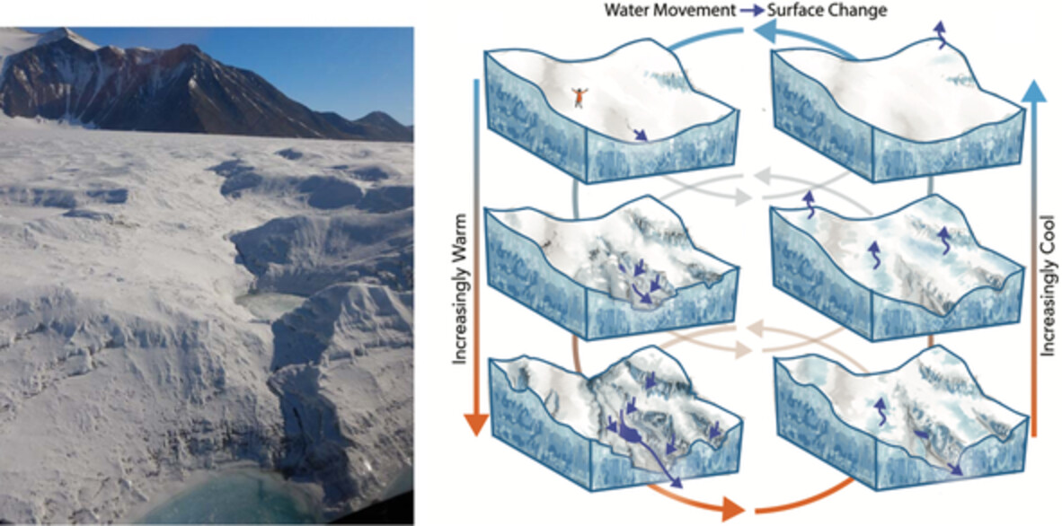
Analysis of repeat lidar coupled with long term records indicates a roughening glacier surface in response to recent warm events. This is causing increased meltwater generation and delivery to the downstream ecosystem. We present a conceptual model of cold-based glacier surface evolution, which can be used as a basis for interrogating climate change impacts in other polar systems.
Amount and reactivity of dissolved organic matter export are affected by land cover change from old-growth to second-growth forests in headwater ecosystems
- First Published: 08 August 2021
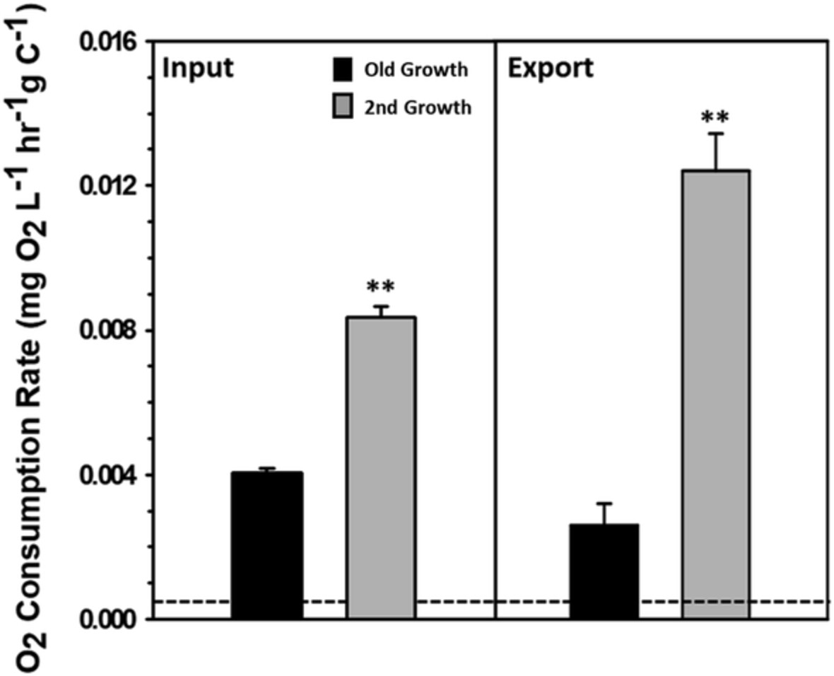
Land cover changes that alter forest structure and forest species composition affect the quantity and composition of dissolved organic matter (DOM) transferred from terrestrial to aquatic ecosystems. Our findings suggest that land cover shifts in a subalpine forest following regeneration after timber harvest increase the proportion of biologically reactive DOM in both litter inputs and subsurface leachate, but decrease total C exports to headwater streams.
Increasing temperature and flow management alter mercury dynamics in East Fork Poplar Creek
- First Published: 09 August 2021
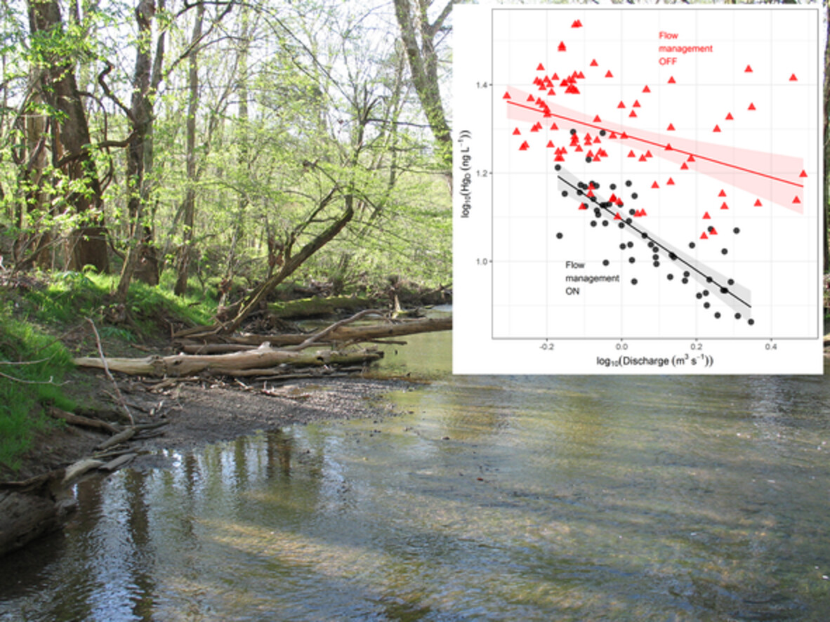
Changing flow management practises and increasing temperature in a low-order stream resulted in changes to mercury and methylmercury concentrations and loading. These changes resulted from a combination of in-stream and broader climate-scale factors affecting solid-water partitioning and mercury methylation.
Little River Experimental Watershed, a keystone in understanding of coastal plain watersheds
- First Published: 04 August 2021
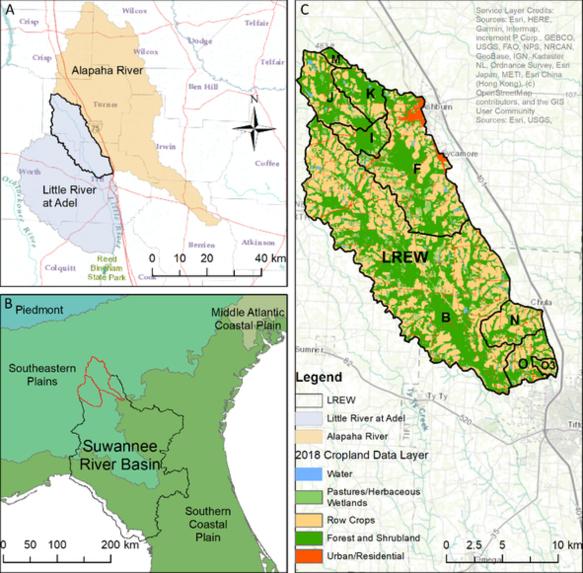
Long-term (52 years) of streamflow data are currently available for nine flow measurement sites in the US EPA Level III Southeastern Plains ecoregion. Hydrologic comparisons across several regional watersheds indicated few differences. Differences found for a smaller nested watershed indicate significant changes in crop and forest coverage can alter long-term hydrologic characteristics.
RESEARCH ARTICLES
Combined influences of irrigation diversions and associated subsurface return flows on river temperature in a semi-arid region
- First Published: 25 June 2021
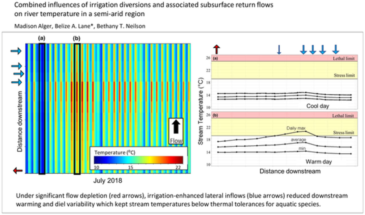
Under high flow depletion, irrigation-enhanced lateral inflows reduced downstream warning and steam temperature diel variability and may prevent streams from exceeding thermal tolerance thresholds for aquatic species.
Temporal sampling and role of flux measurements for subsurface heterogeneous characterization in groundwater basins using hydraulic tomography
- First Published: 16 July 2021
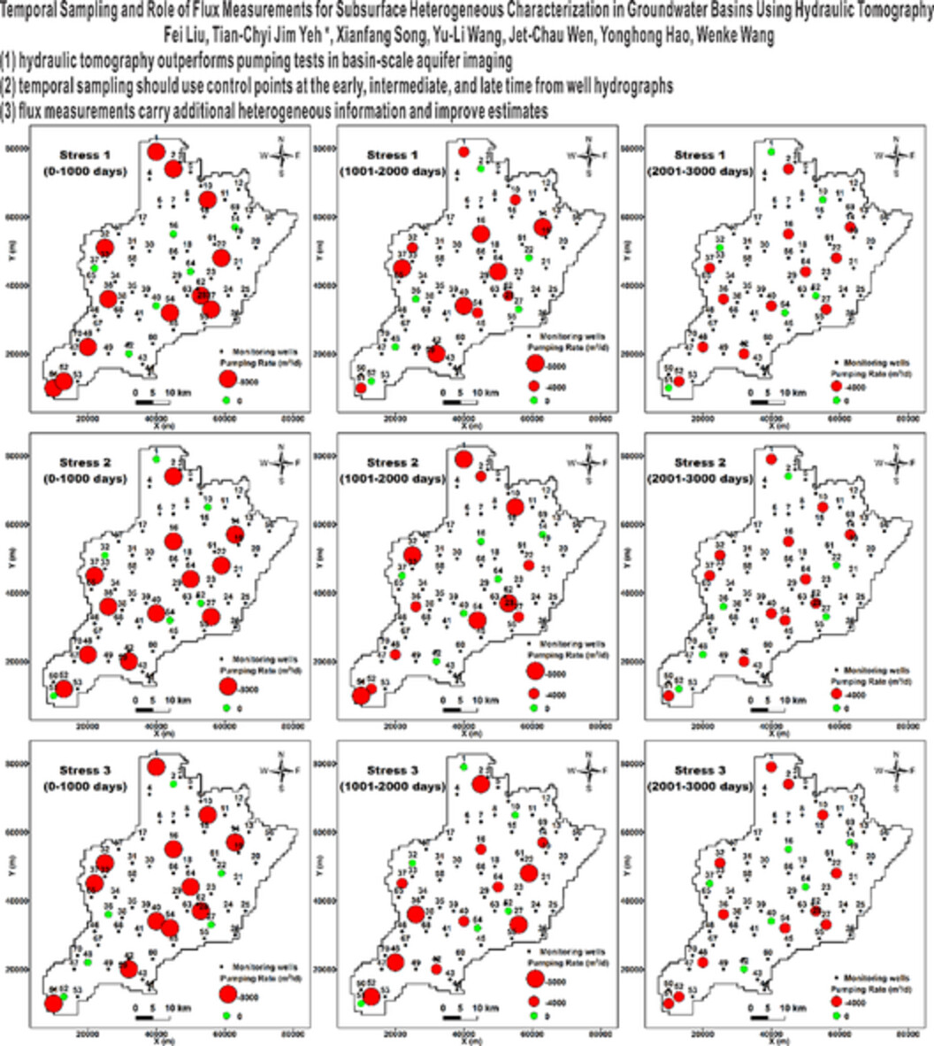
(1) Hydraulic tomography outperforms pumping tests in basin-scale aquifer imaging.
(2) Temporal sampling should use control points at the early, intermediate, and late time from well hydrographs.
(3) Flux measurements carry additional heterogeneous information and improve estimates.
Developing machine learning-based snow depletion curves and analysing their sensitivity over complex mountainous areas
- First Published: 03 July 2021
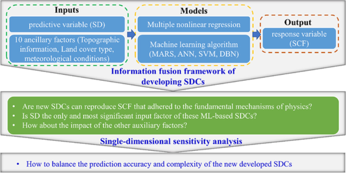
- An information fusion framework is proposed to define the relationship between MODIS fractional snow cover (SCF) area and snow depth (SD) as well as 11 auxiliary factors based on four prevailing machine learning (ML) algorithms
- The single-dimensional sensitivity analysis to investigate the physical rationality of the developed information fusion framework
Surface water–groundwater interactions of Xiluodu Reservoir based on the dynamic evolution of seepage, temperature, and hydrochemistry due to impoundment
- First Published: 05 July 2021
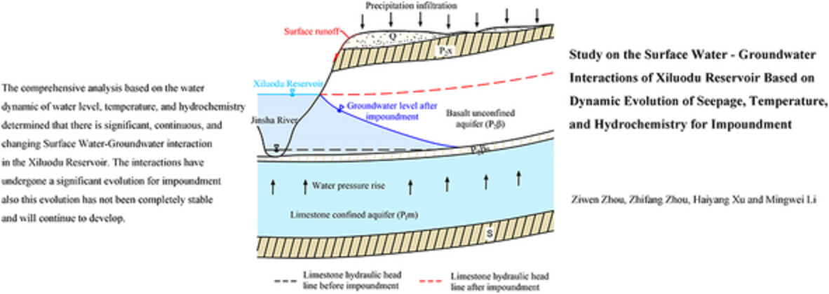
The comprehensive analysis based on the water dynamic of water level, temperature, and hydrochemistry determined that there is significant, continuous and changing surface water–ground water interaction in the Xiluodu Reservoir. The interactions have undergone a significant evolution for impoundment also this evolution has not been completely stable and will continue to develop.
A comprehensive assessment framework for attributing trends in streamflow and groundwater storage to climatic and anthropogenic changes: A case study in the typical semi-arid catchments of southern India
- First Published: 06 July 2021
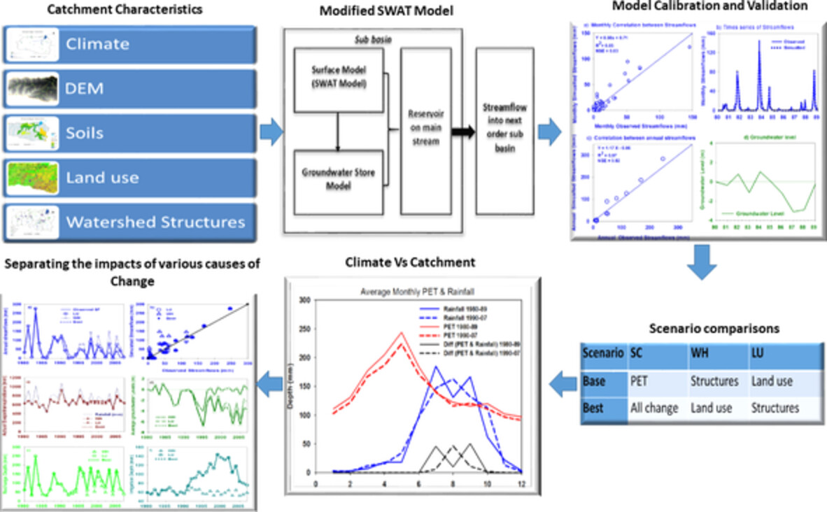
This study used an investigative approach to attributing hydrologic changes to various internal and external drivers of change in the Himayat Sagar catchment. The model results indicated that the decline in potential evapotranspiration (PET) seems to be partially offsetting a significant response to changes in rainfall. The impact of land use change on streamflow is larger than the impact of hydrological structures. Overall, both exogenous and endogenous changes have large impacts on catchment hydrology and have to be considered together.
Post-drought increase in regional-scale groundwater nitrate in southwest Germany
- First Published: 11 July 2021
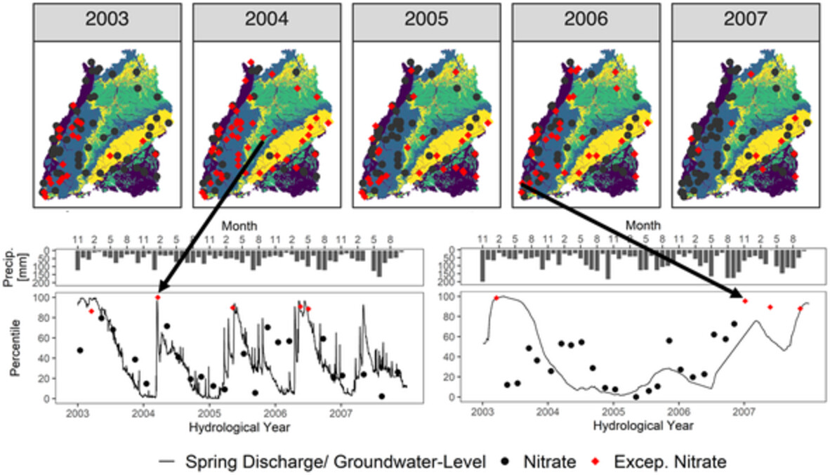
Analyzing data from 41 springs and 44 groundwater wells in southwest Germany we found that 91% of all monitoring sites showed at least one exceptionally high nitrate concentration as a response to the 2003 drought event. Springs generally showed quicker (median of 101 days) but weaker (median of +1.3 mg/L) reactions than groundwater wells (185 days, +3.4 mg/L). Overall, we demonstrate that post-drought nitrate increase in groundwater is omnipresent, while different landscapes and hydrogeological characteristics create a diverse regional pattern.
A physically constrained wavelet-aided statistical model for multi-decadal groundwater dynamics predictions
- First Published: 12 July 2021
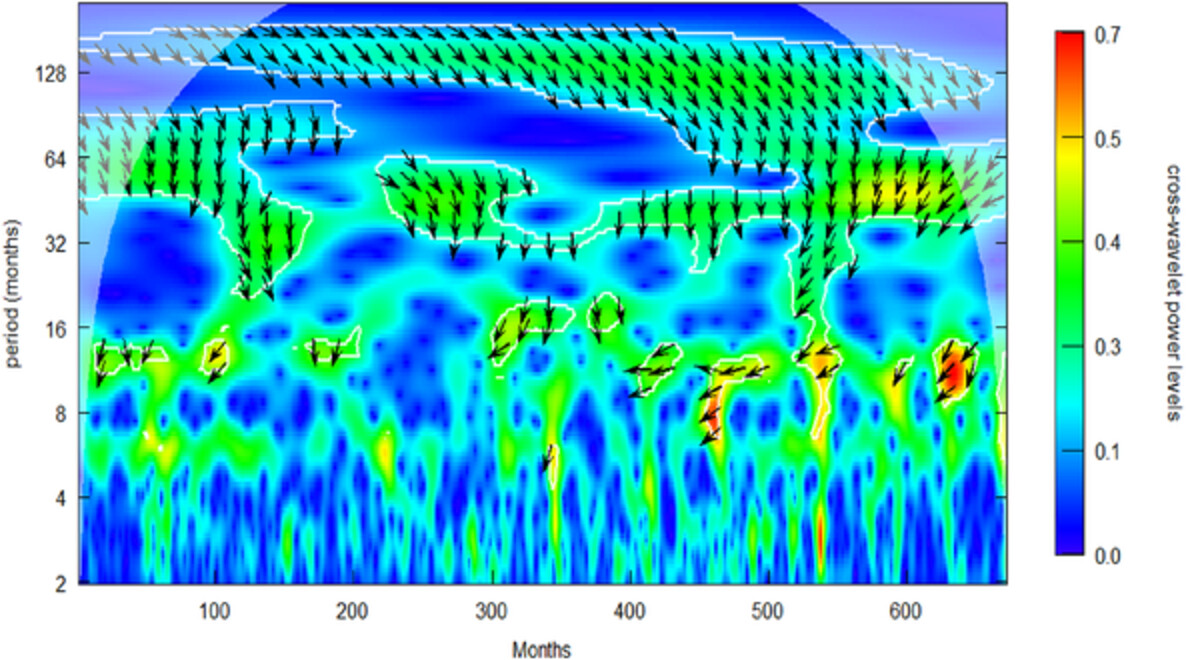
The proposed method integrates statistical correlations enhanced with wavelet analysis into the known principles of groundwater hydraulics including convolution, superposition and the Cooper–Jacob solution. The systematic approach identifies two patterns of cross-correlations between groundwater levels and rainfall using wavelet analysis, indicating low-frequency variabilities are critical for long-term predictions. Evaluation of the model by the fixed-block cross-validation, traditional split calibration-validation and the moving-block bootstrap regression analysis indicate the physically constrained wavelet-aided model can be a reliable tool for long-term groundwater level forecasts.
Flow directions of stream-groundwater exchange in a headwater catchment during the hydrologic year
- First Published: 16 July 2021
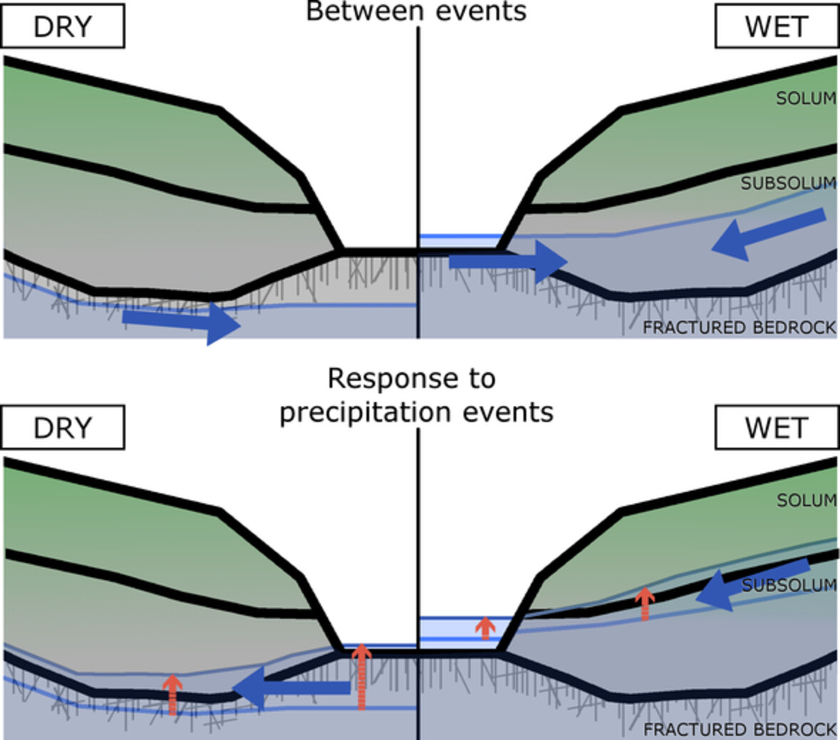
This work investigates the drivers of near-stream groundwater dynamics and stream-groundwater exchange across the hydrologic year. Our results stress the time-variant role of the position of the groundwater table with respect to the fractured bedrock, precipitation depth and intensity, upslope-footslope connectivity and streamwater level in determining the flow dynamics.
INVITED COMMENTARIES
Behind every robust result is a robust method: Perspectives from a case study and publication process in hydrological modelling
- First Published: 10 June 2021
RESEARCH AND OBSERVATORY CATCHMENTS: THE LEGACY AND THE FUTURE
Streamflow response to native forest restoration in former Eucalyptus plantations in south central Chile
- First Published: 20 June 2021
- This study is the first to test streamflow response to native forest restoration in former fast-growing Eucalypt forest plantations.
- Streamflow increased persistently through the first decade of restoration of native forests from planted seedlings and natural regeneration of diverse species.
- Projected climate change drying trends in south central Chile indicates restoration of native forests is key for the recovery of streamflow and water provision.
RESEARCH ARTICLES
The impact of stream-groundwater exchange on seasonal nitrate loads in an urban stream
- First Published: 26 July 2021
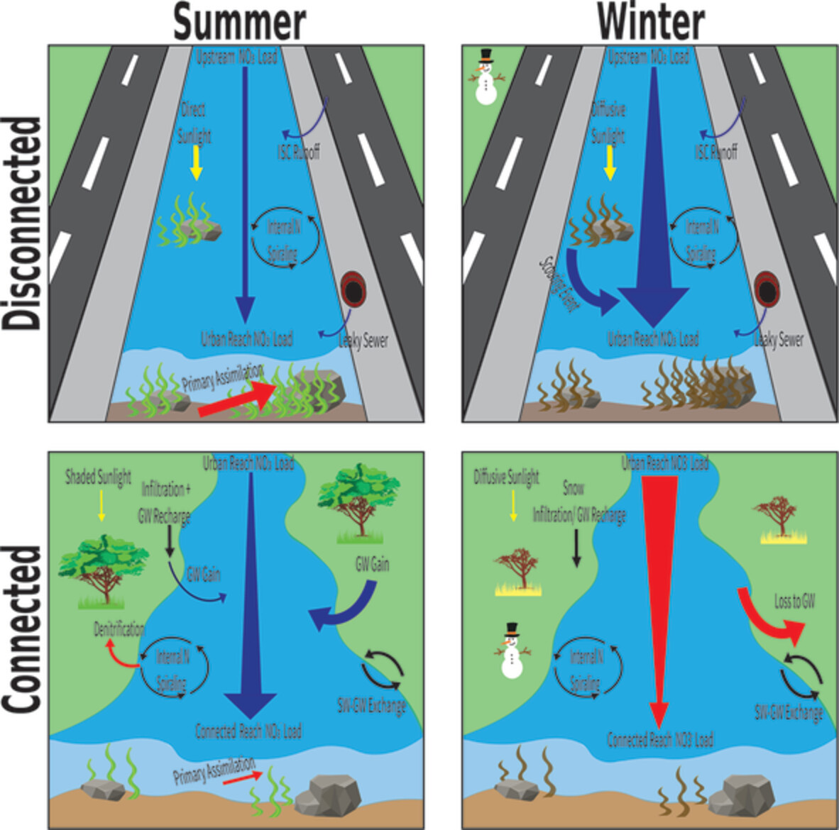
Nitrate loads in urban streams are impacted by different processes in reaches that are disconnected or connected to groundwater in summer and winter conditions.
Conceptualizing a multi-layered shingle aquifer model based on volcanic stratigraphy and water inflow to lava caves in Jeju Island, Korea
- First Published: 21 July 2021
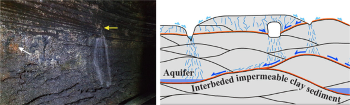
Productive basaltic aquifers on volcanic islands have highly heterogeneous hydrogeological properties depending on the volcanic stratigraphy. From observations of water inflow to large lava tube caves during storm events and monthly monitoring, we found that low-permeability palaeosol layers intercalated between lava flows control most water inflow to the cave, resulting in high water discharge from areas of the cave wall where those layers are exposed. Considering the common and laterally extensive presence of vertically stacked palaeosol layers between lava flows on the island, we developed a new hydrogeological conceptual model of volcanic aquifers comprising vertically and laterally interconnected perched aquifers constrained by palaeosol layers in both coastal and mountainous areas.
A deterministic river temperature model to prioritize management of riparian woodlands to reduce summer maximum river temperatures
- First Published: 19 July 2021
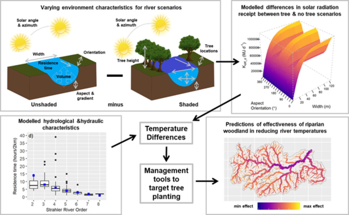
This study developed a deterministic river temperature model driven by energy gains from solar radiation, modified by water volume and residence time. Solar radiation varied with channel shading in response to channel width, orientation, aspect, gradient and tree height. A planting prioritisation metric was developed by comparing scenarios with and without riparian woodland to identify where trees can most effectively reduce summer temperatures. This metric can be mapped nationally, with a reach scale resolution and used to guide planting.
Spatiotemporal shifts in key hydrological variables and dominant factors over China
- First Published: 22 July 2021
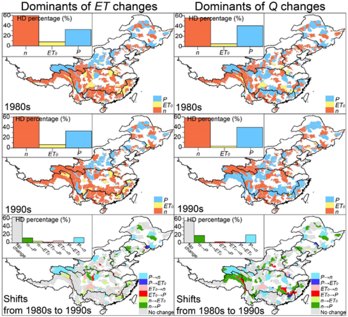
- Changes in ET and Q during 1980s and 1990s (relative to 1961–1980) were analysed across 426 hydrological divisions (HDs) of China.
- In 1980s and 1990s, ET (Q) decreased over roughly (higher than) 50% HDs, but with different spatial patterns and magnitudes.
- Based on contributions of P, reference ET and catchment parameter (n) to ET and Q changes, dominants were examined and were detected to shift from 1980s to 1990s, primarily from P to n.
Deep-learning based projection of change in irrigation water-use under RCP 8.5
- First Published: 22 July 2021
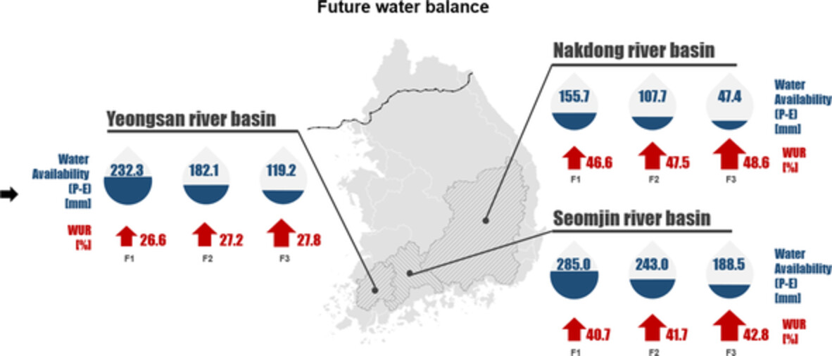
This study proposed a deep-learning based model to estimate agricultural water withdrawal using hydro-meteorological variables. The relationships between meteorological variables and stream water use rate (WUR) were quantified using a deep belief network (DBN). As a result, this DBN with potential evapotranspiration (PET) provided better performances than precipitation to estimate the WUR. The PET of multi-model scenarios for Representative Concentration Pathways 8.5 would be increased and thus leads to increase WUR estimated by DBN during the future period.
Understanding the peak growing season ecosystem water-use efficiency at four boreal fens in the Athabasca oil sands region
- First Published: 26 July 2021
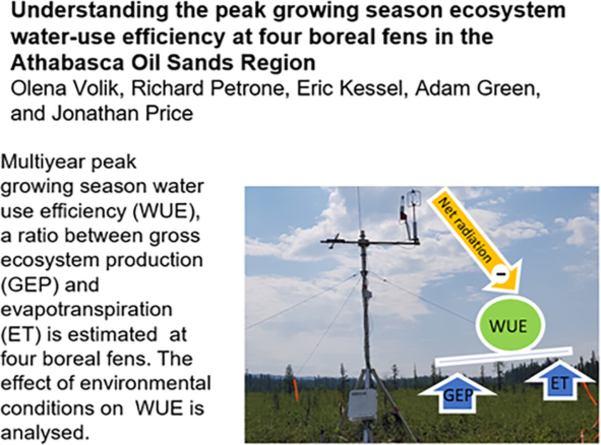
Multiyear peak growing season water use efficiency (WUE) a ratio between gross ecosystem production (GEP) and evapotranspiration (ET) is estimated at four boreal fens. The effect of environmental conditions of on WUE is analysed.
Simulating low flows over a heterogeneous landscape in southeastern Poland
- First Published: 24 July 2021
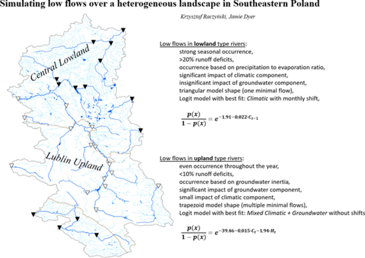
Low flows in lowland type rivers:
- strong seasonal occurrence,
- >20% runoff deficits,
- occurrence based on precipitation to evaporation ratio,
- significant impact of climatic component,
- insignificant impact of groundwater component,
- triangular model shape (one minimal flow),
- Logit model with best fit: Climatic with monthly shift
Low flows in upland type rivers:
- even occurrence throughout the year,
- <10% runoff deficits,
- occurrence based on groundwater inertia,
- significant impact of groundwater component,
- small impact of climatic component,
- trapezoid model shape (multiple minimal flows)
- Logit model with best fit: Mixed Climatic + Groundwater without shifts
Spatial and temporal variability of water table dynamics in an afforested catchment of the Central Spanish Pyrenees
- First Published: 16 July 2021
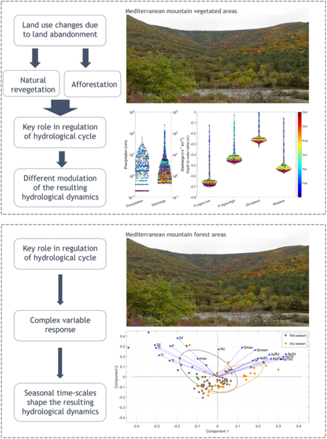
- Spatial and temporal analysis of water table dynamics in afforestation and natural plant colonization areas in the Central Spanish Pyrenees.
- Natural revegetation areas have a marked seasonal cycle with short saturation periods during winter and spring.
- Afforestation areas have a seasonal cycle with fast responses and rapid oscillations.
Canopy structure metrics governing stemflow funnelling differ between leafed and leafless states: Insights from a large-scale rainfall simulator
- First Published: 28 June 2021
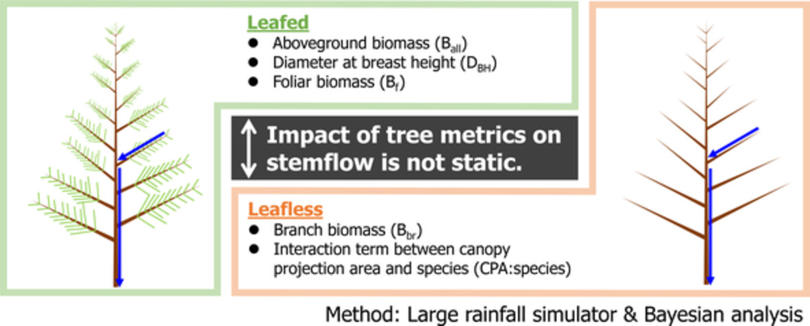
Using a large-scale rainfall simulator, the canopy structural metrics that differentially influence stemflow funnelling ratios were pinpointed for three tree species between leafed/leafless canopy states to examine whether canopy structure metrics exert a static control on stemflow funnelling ratios or whether different elements of canopy structure fluctuate in importance between leafed/leafless states. The canopy structure metrics that influenced stemflow funnelling differed substantially between leafed/leafless states. We reject any tacit assumption of a static effect of canopy structure on stemflow funnelling.
The ability of detainment bunds to decrease sediments transported from pastoral catchments in surface runoff
- First Published: 14 July 2021
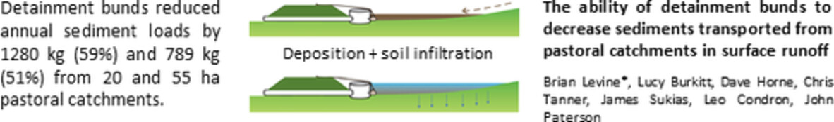
Detainment bunds reduced annual sediment loads by 1280 kg (59%) and 789 kg (51%) from 20 and 55 ha pastoral catchments.
Aquifer recharge from flash floods in the arid environment: A mass balance approach at the catchment scale
- First Published: 21 July 2021
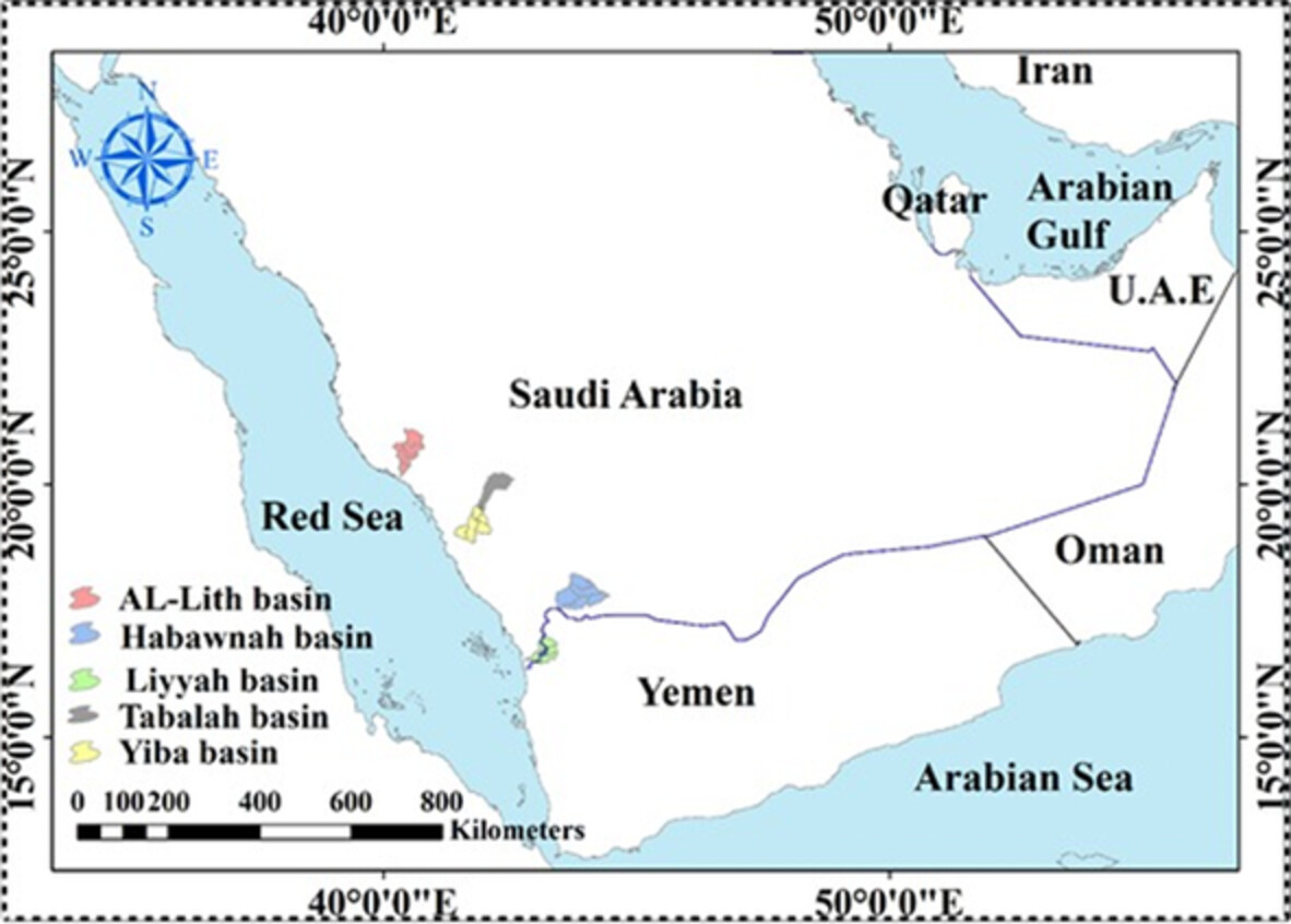
Estimation of the infiltration/natural recharge to groundwater from rainfall is an important issue in hydrology, particularly in arid regions. This paper proposes the application of The Natural Resources Conservation Service (NRCS) mass balance model to develop infiltration (F)–rainfall (P) relationship from flash flood events. Moreover, the NRCS method is compared with the rational and the Ф-index methods to investigate the discrepancies between these methods. The methods have been applied to five gauged basins and their 19 sub-basins (representative basins with detailed measurements) in the southwestern part of Saudi Arabia with 161 storms recorded in 4 years. The F–P relationships developed in this study based on NRCS method are: F = 39% P with R2 = 0.932 for the initial abstraction factor, λ = 0.2. However, F = 77% P with R2 = 0.986 for λ = 0.01. The model at λ = 0.01 is the best to fit the data, therefore, it is recommended to use the formula at λ = 0.01. The results show that the NRCS model is appropriate for the estimation of the F–P relationships in arid regions when compared with the rational and the Ф index methods. The latter overestimates the infiltration because they do not take λ into account. There is no significant difference between F–P relationships at different time scales. This helps the prediction of infiltration rates for aquifer recharge at ungauged basins from monthly and annual rainfall data with a single formula.
CANADIAN GEOPHYSICAL UNION 2020
Naturalizing the freezeup regimes of regulated rivers and exploring implications to spring ice-jam flooding
- First Published: 26 July 2021
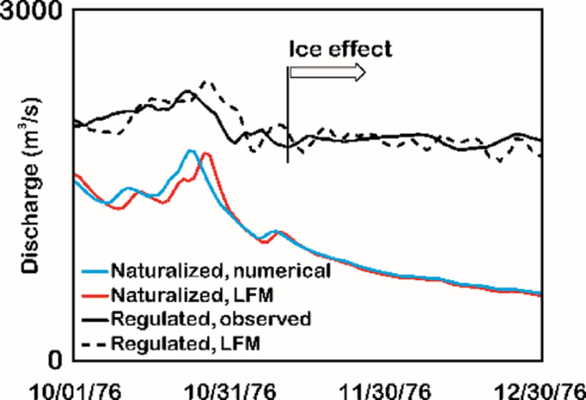
Assessing ecological and socioeconomic impacts of regulated ice-forming rivers across Europe, Asia and North America requires naturalization of their ice regimes. Using reservoir inflows, we develop robust methodology to reconstruct natural freezeup levels and thence explore breakup ice-jam flooding of the PAD, a Ramsar wetland of international importance and a UNESCO World Heritage Site.
RESEARCH ARTICLES
Modelling ecohydrological feedbacks in forest and grassland plots under a prolonged drought anomaly in Central Europe 2018–2020
- First Published: 26 July 2021
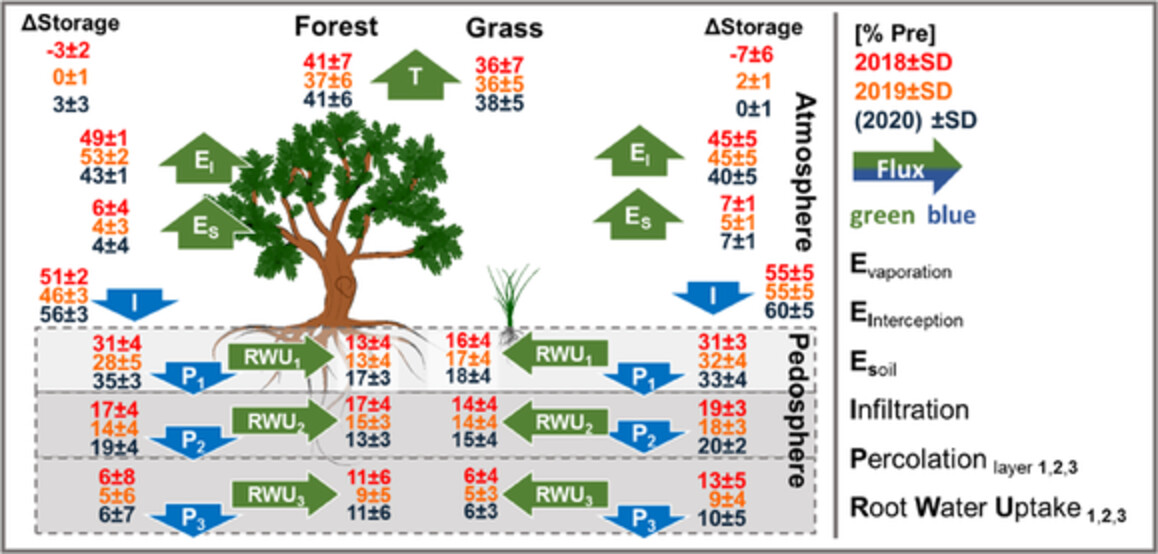
In this study, we included stable water isotopes of bulk soil water (model calibration) and plant xylem (model validation) to model ecohydrological feedbacks in the soil-plant-atmosphere continuum to the European drought 2018 and the following two years. The physically based model was setup at two plot sites in spatial proximity and differing landuse of forest and grassland in the Demnitzer Millcreek catchment in NE Germany. This revealed differences in drought effects and persistence on ecohydrological fluxes and water ages. Whereas the forest site had more variable water uptake strategies and younger bulk soil water ages, the grassland showed less dynamic water ages and root water uptake strategies. Such insights can help to inform the landuse based mitigation of droughts and there multi-year effects in evapotranspiration and groundwater dominated lowlands.
Daily streamflow trends in Western versus Eastern Norway and their attribution to hydro-meteorological drivers
- First Published: 01 August 2021
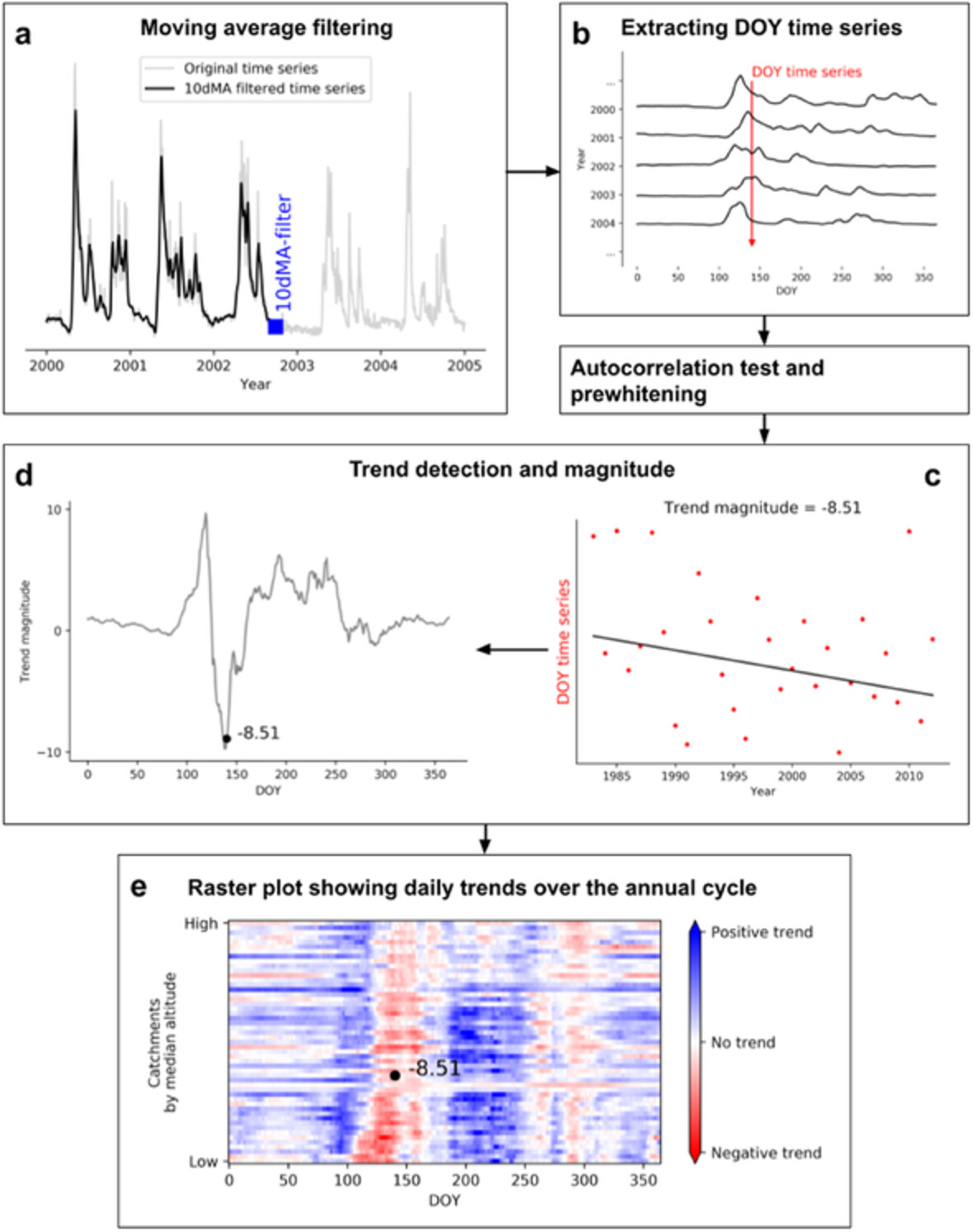
Daily-resolved trend analyses reveal the increasing (decreasing) role of rainfall (snowmelt) on streamflow with differing manifestation in Western versus Eastern Norway. The attribution of daily streamflow trends reveals the importance of other driving processes like increasing glacier melt and evapotranspiration in addition to changes of snowmelt and rainfall.
Tile drainage causes flashy streamflow response in Ohio watersheds
- First Published: 26 July 2021
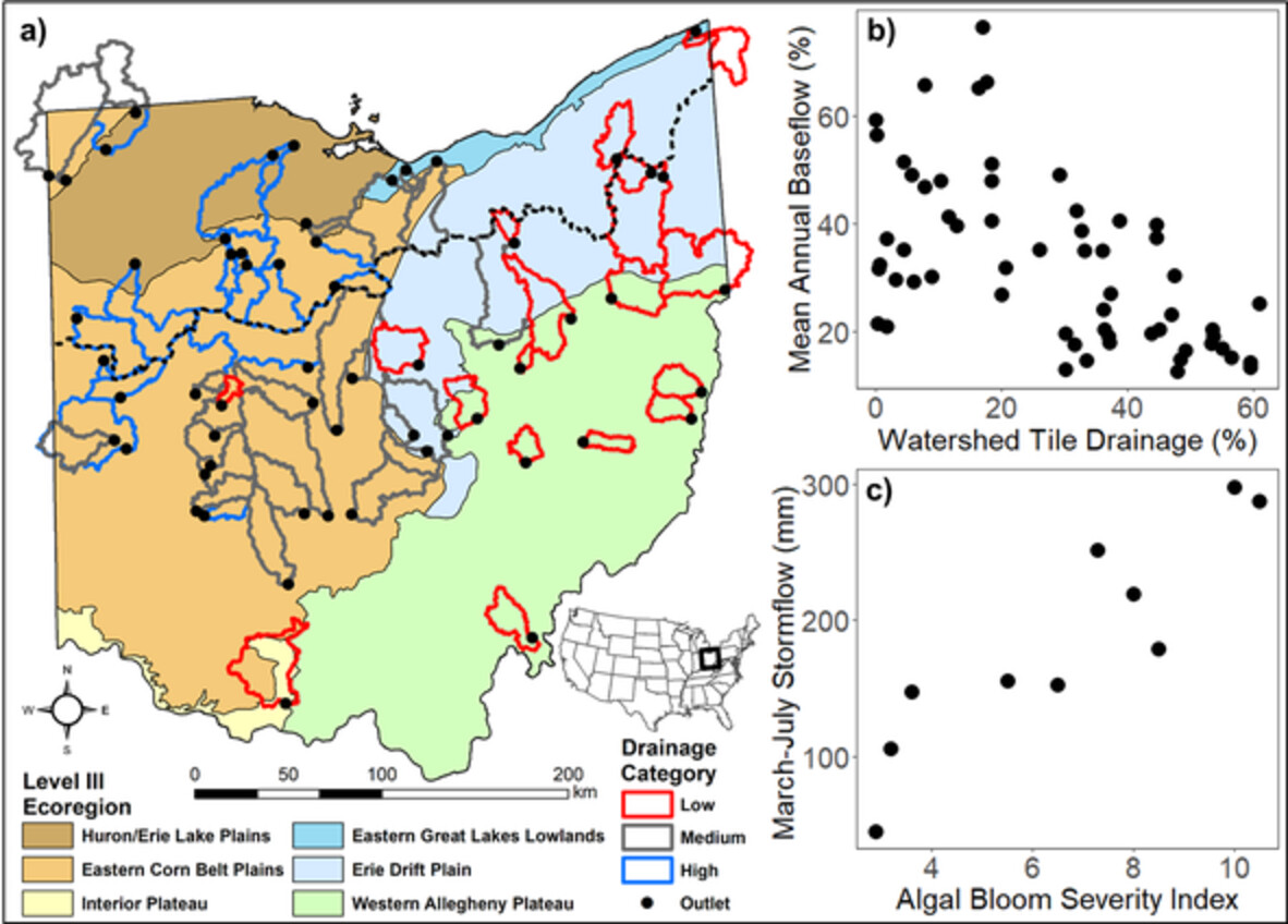
Streamflow response from 2010 - 2019 was compared for 59 Ohio watersheds with varying percentages of tile drainage (a) to determine if tile drainage affected runoff metrics. Overall, watersheds with a high percentage of tile drainage showed a flashier streamflow response. Mean annual baseflow was significantly negatively correlated to tile drainage (b). March – July stormflow in watersheds with high percentages of tile drainage was significantly positively correlated to the Western Lake Erie Bloom Severity Index (c). Increased stormflow percentages and total amounts are problematic for downstream nutrient transport. Management efforts that reduce the hydrologic response time to storm events, such as buffer strips, wetland restoration, or drainage water management are likely to improve downstream aquatic health conditions by limiting the transport of nutrients after storm events.
Role of reservoir regulation and groundwater feedback in a simulated ground-soil-vegetation continuum: A long-term regional scale analysis
- First Published: 07 August 2021
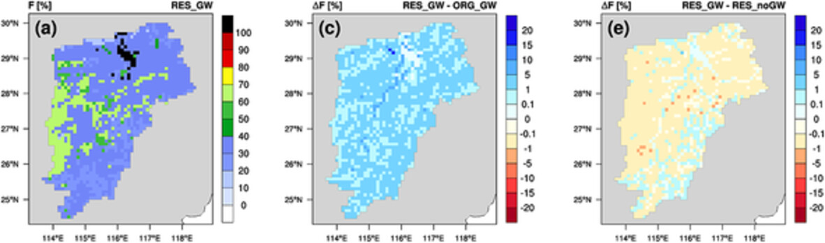
- An existing process-based reservoir network module is implemented into the terrestrial component NOAH-HMS of the atmospheric–hydrologic modelling system WRF-HMS.
- The inclusion of reservoir regulation leads to major changes in the simulated groundwater recharges and evaporation from reservoirs at local scale, but does not alter the strength of the groundwater feedback.
- Reservoir regulation and groundwater feedback play different roles in modifying the regional terrestrial water cycle for the Poyang Lake basin, particularly with respect to the partitioning of the simulated evapotranspiration.
Suspended solids induce increasing microbial ammonium recycling along the river-estuary continuum of the Yangtze River
- First Published: 10 August 2021
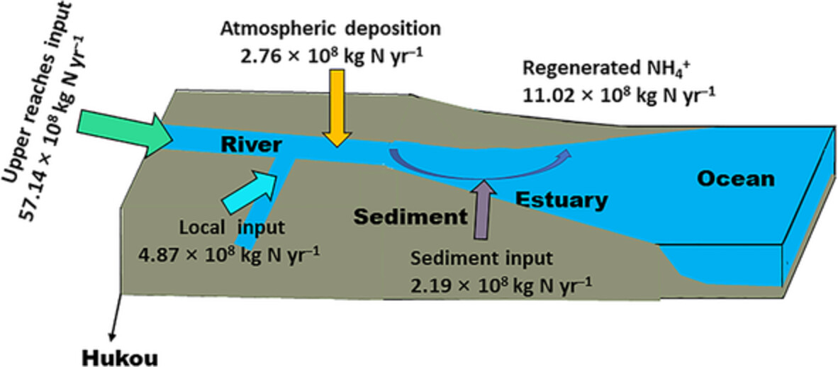
A schematic illustration of different N sources in the Yangtze River
Chemical weathering and CO2 consumption in the glaciated Karuxung River catchment, Tibetan Plateau
- First Published: 01 August 2021
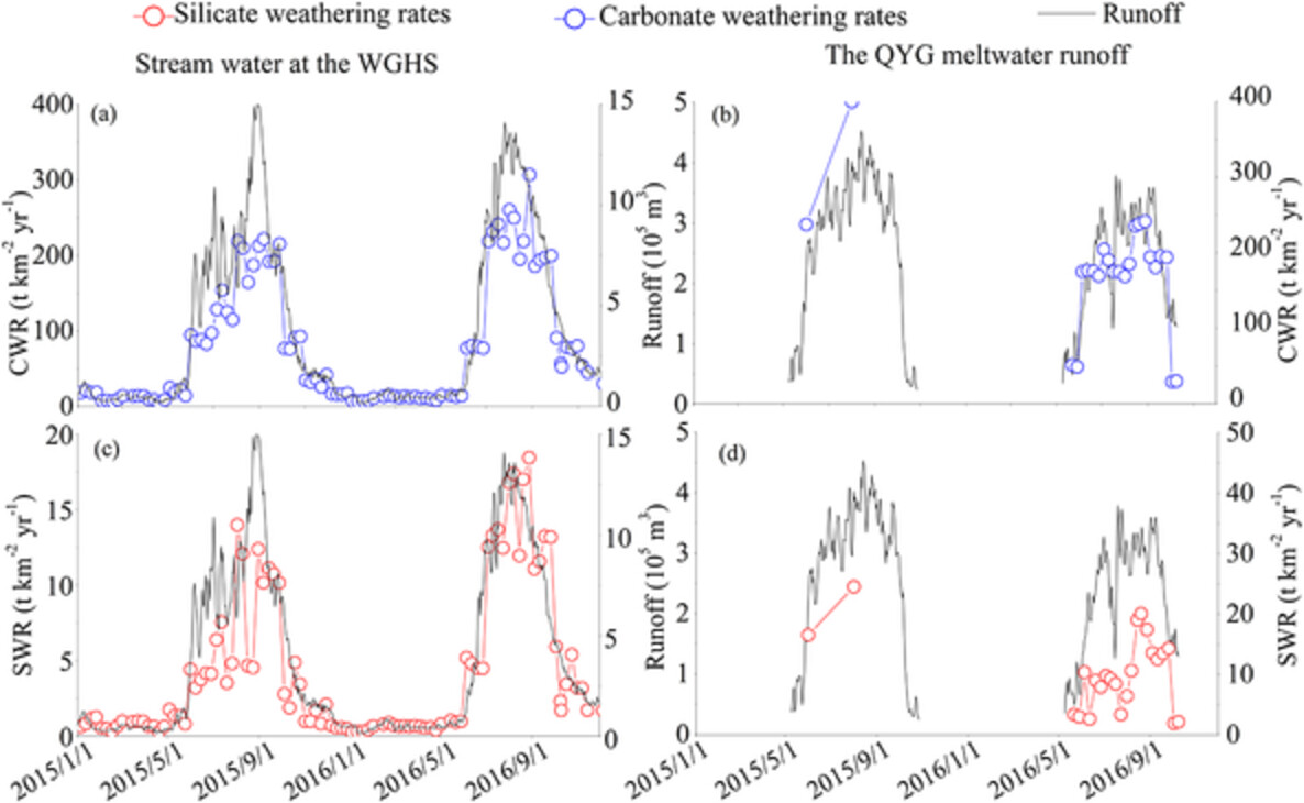
- The low air temperatures over glaciers at the high elevation inhibited the weathering of silicate rock but have less influence on the weathering of carbonate rock.
- The widely distributed alluvial deposits, higher air temperatures, thicker soils, and denser vegetation found at the downstream promoted the weathering of silicate rock.
- The pyrite oxidation occurring in debris-rich environments was the dominant reaction in subglacial environments and produced sulfuric acid.
- The involving of sulfuric acid in the weathering of carbonate led to potentially low atmospheric CO2 consumption by carbonate weathering.
An assessment of large-scale flood modelling based on LiDAR data
- First Published: 23 August 2021
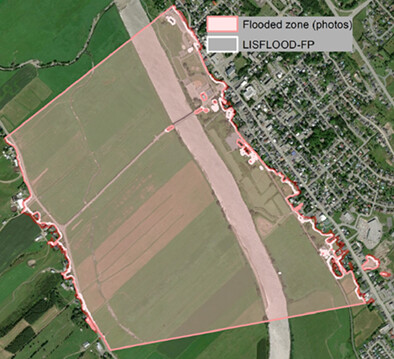
A novel approach based on LiDAR data shows significant improvements to large-scale flood modelling at the watershed scale with standard deviation in the range of 0.30 m and an average fit of around 90%. Novelties include a GIS-automated procedure to estimate bathymetry from LiDAR water surface data using hydraulic inverse problem combined with a tiling approach to greatly improve processing time to simulate large watersheds with a 10-m resampled LiDAR DEM.
INVITED COMMENTARIES
SCIENTIFIC BRIEFING
Rainfall, runoff and shallow groundwater response in a mixed-use, agro-forested watershed of the northeast, USA
- First Published: 16 July 2021
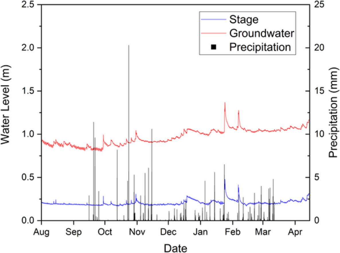
Average stage (m), average shallow groundwater (GW) level (m) and precipitation (mm) logged at 30-minute intervals during the study period (August 2019 – April 2020) in Moore's Run Watershed.
HPEYE
Uncovering the hillslope scale flow and transport dynamics in an experimental hydrologic system
- First Published: 18 August 2021
CORRIGENDUM
Sign up for email alerts
Tools
More from this journal
- Aims and Scope
- Collections/ Special Issues
- Call for Papers: Laboratory and field experiments on soil and rainfall characteristics for studying water erosion processes
- Call for Papers: Drought dynamics and vulnerability
- Pluvial Flooding: Maturing process understanding from data scarcity into data abundance
- Call for Papers: Hydrological processes in lowlands and plains
- Call for Papers: Preferential flow and eco-hydrological processes in the vadose zone
- MG Anderson Awards
- Top Cited Awards
- CHINA Collection
- SEO Guidelines for Authors
HP's Award Winning Articles
We're delighted to announce our 2024 prize winners!
MG Anderson Award
Forest cover lessens hurricane impacts on peak streamflow
Jazlynn Hall, Martha Scholl, James Shanley, Serena Matt, María Uriarte
Top Cited Paper
On strictly enforced mass conservation constraints for modelling the Rainfall-Runoff process
Jonathan M. Frame, Frederik Kratzert, Hoshin V. Gupta, Paul Ullrich, Grey S. Nearing
Top Cited Invited Commentary
Benchmarking hydrological models for an uncertain future
Keith Beven