

Journal list menu

 Issue
IssueRiver: Volume 4, Issue 1
i-iii, 1-133February 2025
Export Citations
Download PDFs
ISSUE INFORMATION
COMPREHENSIVE REVIEW
Check dams on China's Loess Plateau: An overview
- Pages: 1-20
- First Published: 26 January 2025
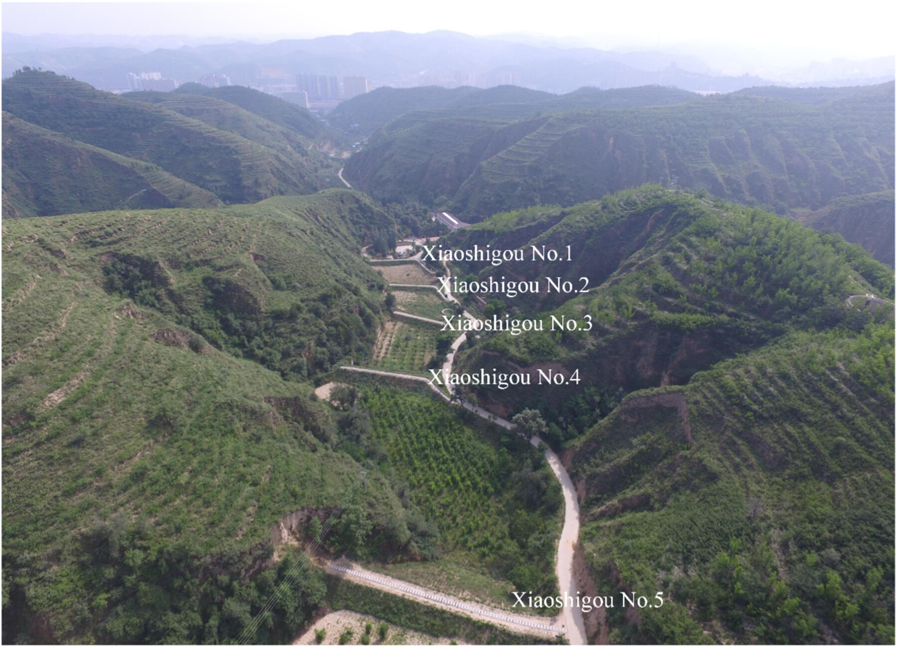
Great achievements of check dam construction on the China's Loess Plateau have been gained; however, the flood incidents on check dams have been frequently reported for the past decades. To migrate the breach risk of check dams due to floods, the main advances in the flood migration techniques achieved by the authors' research group are reviewed.
PERSPECTIVE
Developing river ethics: Advancing the understanding of water governance principles and promoting the modernization of water governance systems and capabilities
- Pages: 21-28
- First Published: 17 February 2025
Forever but not everywhere? Unexpected non-detection of per- and polyfluoroalkyl substances (PFAS) in major Philippines rivers
- Pages: 29-35
- First Published: 21 February 2025
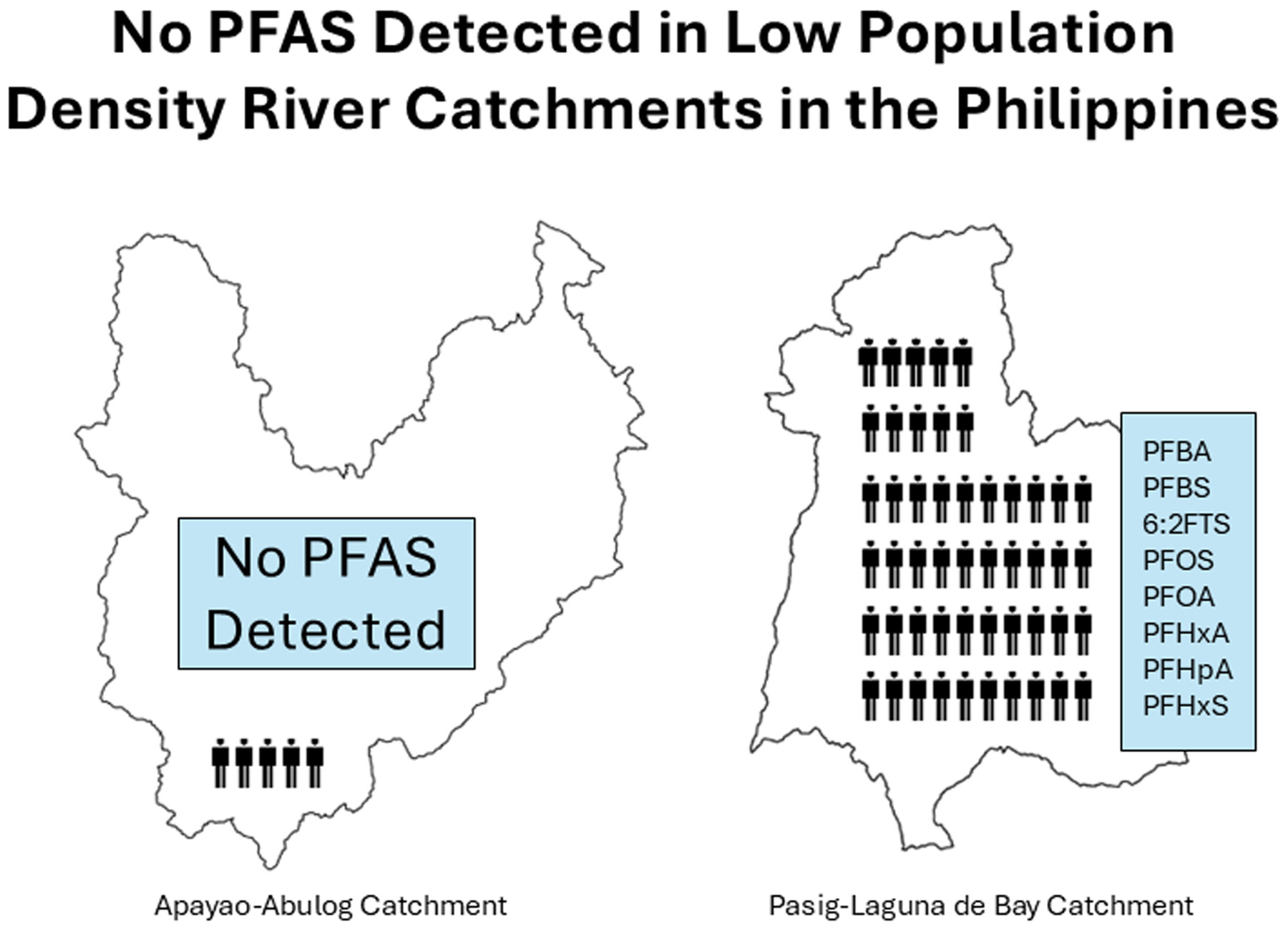
No PFAS were detected in major Philippines rivers despite reported increases in the Asia-Pacific Region. Sampling programmes typically focus on populated regions and a small number of compounds so may present an incomplete picture of global PFAS trends in rivers.
RESEARCH ARTICLE
Shifts in phytoplankton communities in inland waterways: Insights from the Beijing–Hangzhou Grand Canal, China
- Pages: 36-43
- First Published: 09 February 2025
AquaVar decision support system for water resource management: Lessons learned from the first five years of operation
- Pages: 44-54
- First Published: 11 February 2025
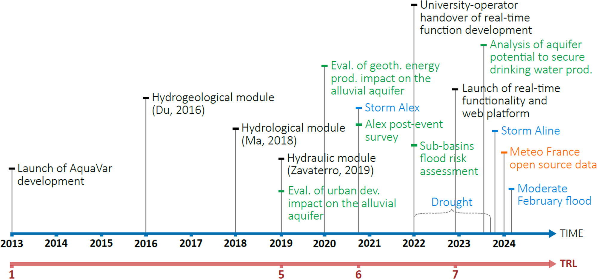
AquaVar is a decision support system (DSS) developed for water resource management in the French Mediterranean Var watershed. The results obtained during the first 5 years of use under operational conditions are shown. Lessons are drawn, covering topics such as DSS modularity, evolution, data positioning, technology, and governance.
Integrated optimization and coordination of cascaded reservoir operations: Balancing flood control, sediment transport and ecosystem service
- Pages: 55-69
- First Published: 06 February 2025
Three-dimensional characterization of particle morphology in natural gravel and blasted rock fragments using SfM-MVS photogrammetry
- Pages: 70-83
- First Published: 22 January 2025
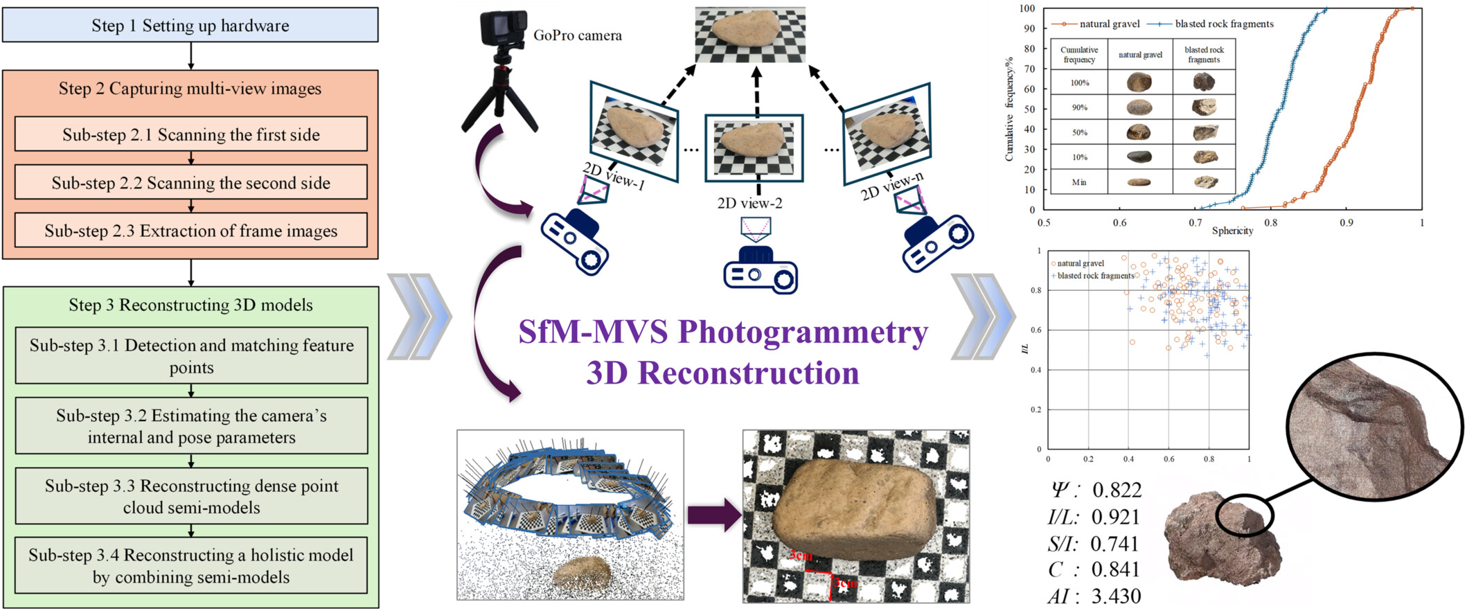
Structure from Motion-Multi-View Stereo photogrammetry 3D reconstruction.
Fluvio-hydrological characteristics and diverse bedrock geology control the dynamic growth, truncation, and amalgamation of bedrock streambed and marine potholes
- Pages: 84-105
- First Published: 22 January 2025
Underground mining impact on groundwater in Kuye River Basin, China: A coupling model study
- Pages: 106-115
- First Published: 17 February 2025
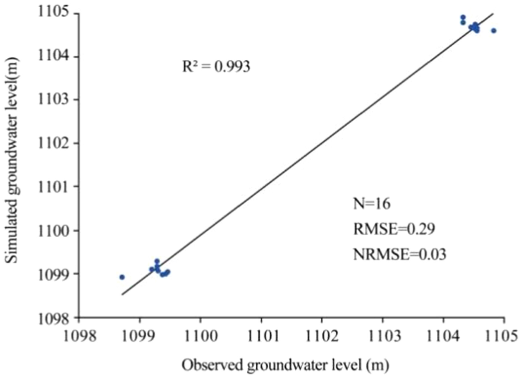
The Kuye River Basin has experienced a rapid depletion of groundwater due to the increased coal production. In this study, by introducing the empirical equations derived from the three zone theory in the coal mining industry in China as a boundary condition, a calculation model was developed by coupling the soil and water assessment tool and visual modular three-dimensional finite-difference ground-water flow model (SWAT-VISUAL MODFLOW). The model was applied to several coal mines in the basin to quantify the groundwater impact of underground mining. Preventing surface subsidence due to underground mining can help protecting the basin's groundwater.
Flood frequency analysis and susceptibility zonation of the Haora River Basin, Northeast India
- Pages: 116-133
- First Published: 25 February 2025
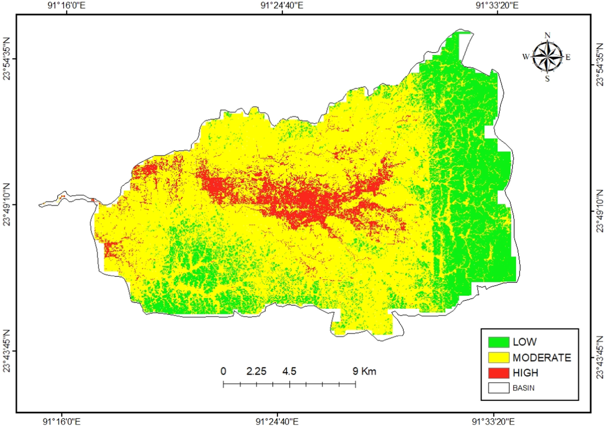
This study evaluates the flood frequency and susceptibility of the Haora River basin in Tripura, India, using the Log-Pearson Type III (LP-III) and Gumbel Extreme Value-1 distributions. The LP-III model was identified as the most suitable for estimating peak discharges, while flood susceptibility mapping, integrating 16 thematic layers through the Analytical Hierarchy Process, revealed that 8% of the area is highly susceptible to flooding. These findings highlight the need for targeted flood management interventions in the basin.
Sign up for email alerts
Tools
Published on behalf of the China Institute of Water Resources and Hydropower Research (IWHR)

More from this journal

Understanding open access
As an open access journal, all articles in River will be freely available to read, download and share immediately upon publication. Learn more about open access:
Latest activities
