Fluvio-hydrological characteristics and diverse bedrock geology control the dynamic growth, truncation, and amalgamation of bedrock streambed and marine potholes
Abstract
A total of 393 potholes (368 fluvial and 25 marine potholes) were studied at seven different sites in both the fluvial and marine environments. Diverse bedrock properties and large-scale delivery of tools and grinders regulate the dynamic growth, truncation, and amalgamation of potholes. Therefore, the principal objectives of the study are (i) to examine the relationship between the growth of potholes and substrate lithological with structural characteristics (applying geospatial and Schmidt hammer for rock strength analysis) and (ii) to measure the morphology, and size of tools and grinders, processes of truncation and amalgamation in hydro-geomorphic environment using various indices and field techniques. The result showed that large potholes are stretched in the direction of lineament axes and roughly parallel to the river flow direction. Here, the steady growth of pothole depth-diameter is controlled by active bedrock structures, tools, or grinders, and monsoonal high-velocity bank full discharge. Consequently, the deepening and widening of potholes are relatively slow at Bindu, Deuli, and marine beach Neil Island due to fewer structures and little supply of tools or grinders. In small stretches, (Damodar, Subarnarekha, and Rarhu) canyons and gorge-like features (bedrock incision) are formed at Rajrappa, Bhakuyadi, and Guridih sites due to cyclic truncation and amalgamation. Truncation and amalgamation processes restrict the vertical depth threshold value of potholes within 3 m, particularly at Rajrappa, Bhakuyadi, and Guridih sites. Scientific study of the pothole's dynamic growth is greatly necessary for the different environmental engineering and river hydraulic projects like excavation, dredging, and dam or barrage construction. Successively, it is essential to compute the cost of rock excavation or dredging, primarily for the mechanical strength of the bedrock river channel and its stability.
1 INTRODUCTION
Bedrock streambed pothole or sculpted form is a concavity exhumed by tools (particles size less than 2 mm) or grinders (particles size greater than 2 mm diameter) within a steady vortex (Bera & Bhattacharjee, Ghosh, et al., 2019, 2021; Hancock et al., 1998; Ji et al., 2018; Kale & Joshi, 2004; Kale & Shingade, 1987; Pelletier et al., 2015; Springer et al., 2005; Whipple et al., 2000). Sometimes, the structure of streambed potholes is just like an arranged “crock” on a bedrock river channel (Bera et al., 2021). Multiple experiments showed that swirling vortex is a result of interactions between running water and primary depression on channel beds (Alexander, 1932; Bera et al., 2021; Dubinski & Wohl, 2013; Elston, 1917; Ortega et al., 2014; Springer et al., 2005; Wohl & Merritt, 2008; Wohl et al., 1994; Wohl, 1993). Dynamic growth of bedrock streambed potholes is a significant process-form study in geomorphology (Hancock et al., 1998; Springer et al., 2005; Whipple et al., 2000). Escalation of the pothole is the result of erosion between the pothole floor and pothole wall (Dhali & Biswas, 2017; Gopal, 2016; Lima & Binda, 2015; Sengupta & Kale, 2011; Springer et al., 2005; Wang et al., 2009; Yin et al., 2016; Bera et al., 2021). The particles (e.g., sand, silt, and clay) that erode the bedrock streambed potholes through abrasion and corrosion are called tools (Gilbert, 1877), whereas the big-sized bed loads (granules, pebbles, cobbles, and boulders) that erode and occupied within pothole floor are called grinders (Bera et al., 2021; Dubinski & Wohl, 2013; Ji et al., 2018; Springer et al., 2005; Wohl & Merritt, 2008; Wohl et al., 1994). Tools or clasts and grinders that reside in potholes may slide, roll, skip, and spin. The presence and coalescence of bedrock streambed or coastal potholes are strongly regulated by lithology and hydro-geomorphological processes (Bera et al., 2019; Dubinski & Wohl, 2013; Ji et al., 2018; Springer et al., 2005; Wohl & Merritt, 2008). Rocky coastal jointed and fractured bedrocks give birth to small sculpted forms through marine transgression and regression (Wang et al., 2010). Principal fluvio-hydrological processes such as plucking, abrasion, and cavitations directly assist in the genesis and dynamic growth of bedrock streambed potholes (Bera et al., 2021; Hancock et al., 1998; Ji et al., 2018, 2019; Miller, 1991; Wohl et al., 1994). The multi-dimensional growth of potholes is also controlled by bedrock structural imprints, stream velocity, and discharge (Bera et al., 2019, 2021). Fluids and particles move along the high-velocity main channel flow path, and centripetal acceleration force is created within the pothole. The descending swirling vortices throw tools toward pothole walls because of centripetal motion but flow direction must be roughly parallel to sculpted or pothole wall surfaces (Springer & Wohl, 2002). The impacts of oblique tools are erosionally less effective compared with more acute impacts of rounded tools (Hancock et al., 1998; Sklar & Dietrich, 2001, 2004). Coarse tools are more capable of eroding substrate than micro sediments because coarse tools may saltate, slide, and roll within potholes (Sklar & Dietrich, 2001). Suspended sediments also accelerate the erosion rate of pothole walls and floors through descending to ascending and ascending to descending flow (Bera et al., 2021; Dubinski & Wohl, 2013; Ji et al., 2018; Springer et al., 2005; Wohl & Merritt, 2008; Wohl et al., 1994). Several studies investigated that immature potholes develop far from the main channel flow path while mature potholes are located along the principal channel flow path or inner channel (Kale & Shingade, 1987; Lorenc et al., 1994). Potholes grow in various types of substrates from soft material clay to resistant bedrock river channel granite (Ortega et al., 2014). Genesis of potholes has been regulated by different external processes such as glacier abrasion (Gilbert, 1906), subglacial meltwater (glacio-fluvial theory; Ljunger, 1930), mechanical abrasion or grinders (Moulin theory; De Charpentier, 1841), and hydraulic erosion (Alexander, 1932) (eddy theory; Alexander, 1932).
At the beginning stage, the rate of vertical erosion is comparatively greater than the sideward erosion (Lorenc & Alonso, 1980; Lorenc et al., 1994) and may eventually amalgamate with one another to grow a longitudinally incessant inner channel (Kale & Shingade, 1987; Shepherd & Schumm, 1974; Wohl, 1993). Consequently, few eroded concavities with approximately elliptical apertures (e.g., cavities, flutes, furrows, and scallops) have been identified wherein the radius (r) is greater than the depth (d). Flutes and scallops drift across channel surfaces and may provide sediments or clasts for pothole growth (Allen, 1968, 1971; Blumberg & Curl, 1974), which is stationary. Bedrock streambed sculpted forms or potholes need hundreds to thousands of years to grow on the resistant substrate (Wohl et al., 1994) even though bedrock streambed potholes can be developed in about 60 years (Kale & Joshi, 2004). Alexander (1932) classified sculpted forms or potholes into three categories (i) eddy holes developed by abrasion in spiraling flow, (ii) gouge holes generated by the oblique impact of speedy currents, and (iii) plunge pool holes produced by falling water. Potholes are also divided into three important classes based on their genesis (Ji et al., 2018): (i) bedrock streambed potholes, (ii) marine or rocky coastal beach potholes, and (iii) hillside potholes.
This scientific study was conducted at three significant sites of the Indian subcontinent the bedrock channel beds of the Chhotanagpur plateau region, the bedrock streambed of the Himalayan region, and the coastal rocky beach of Neil Island (Andaman Islands), India. The dynamic growth of bedrock streambed potholes in the Himalayan Region, and marine beach potholes has not yet been studied. Similarly, the truncation and amalgamation processes of potholes have not been studied, particularly the bedrock streambed of the Chhotanagpur Plateau. This is an actual research gap in this context. Multidirectional growth, truncation and processes of amalgamation have been studied here to comprehend the process-form analysis in fluvial geomorphology. The principal research objectives are (i) to investigate the relationship between the growth of potholes and substrate with structural characteristics on granitic-gneiss bedrock dominant channels applying geospatial and rock strength analysis and (ii) to examine the morphology, processes of truncation and amalgamation in hydro-geomorphic environment using various indices. We hypothesize that most of the potholes occupied clasts, tools, and grinders, and fluvio-hydrological processes are responsible for the multidirectional growth, truncation, and amalgamation of potholes. Testing of hypotheses requires systematic investigation and analysis at different pockets of substrates. We thoroughly assessed the magnitude and attitude of substrate structures at all the sites. Consequently, we also measured the amount and shape of tools and grinders within the potholes, which influence the pothole growth dynamic. Similarly, rock strength in the proximity of potholes has also been examined. The significance of the study is that the dynamic growth of potholes is required to know the mechanical strength of bedrock, particularly for excavation, dam construction, and river dredging for societal development.
1.1 Study area
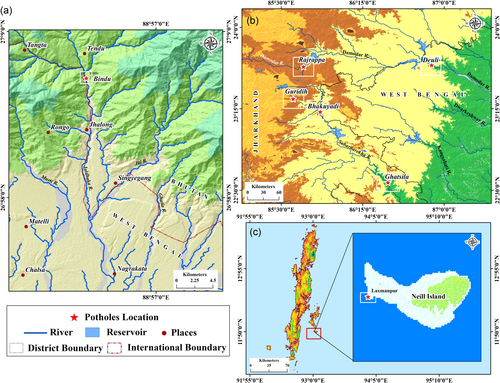
Field measurements of potholes were conducted to characterize the pothole geometries, the size and shape of tools and grinders, and the existence of bedrock structural imprints. Seven field sites were selected to know the comparative dynamic growth of potholes among different sites, such as plateau region, plateau fringe, Himalayan region, and marine rocky beach of India (Figure 1a). Absolute numbers and densities of potholes were comparatively high at selected sites, so sites were not aimlessly chosen. We considered these sites because of the presence of massive potholes along with prominent substrate structures, and these locations have a high potential for geomorphosites tourism. The geographical location and geological attributes of selected sites have been described below.
1.2 Rajrappa site in Hazaribagh plateau
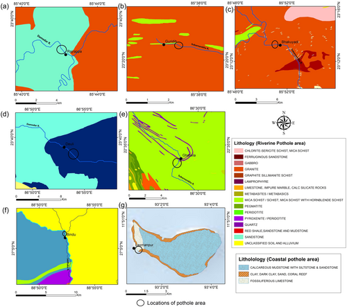
The studied Rajrappa site is confined between the latitude of 23°38′9.56″N to 23°38′27.86″N and longitude of 85°42′27.26″ to 85°42′6.83″ East (Figure 1c). It is situated at the confluence of the rivers Damodar and Bhairavi or Bhera. Bhairavi falls from a height of 9.1 m (30 ft) as Rajrappa falls and it joins in the river Damodar. The total length of river Damodar is 547 km (basin area 22,005 km2) and the mean discharge is 269 m3/s. The Damodar valley at Rajrappa is characterized by a polycyclic two-story valley, but it was the flat and wide valley of the senile phase before the Tertiary upliftment. The river valley was rejuvenated during the Paleogene and Neogene (66 million to 1.8 million years long ago) due to the ramification of Himalayan orogeny, and hence the Damodar made its recent deep and narrow valley of youthful phase within a wide and flat valley (Khedker, 1950; Pandey, 2020; Singh, 1969). The Bhairavi confluence near Rajrappa is an excellent example of a hanging valley, and Damodar Gorge is an incised meander that is formed near Rajrappa Falls. Potholes are coalesced on the channel beds of both rivers, and maximum numbers of potholes are found and examined within a 2 km up stretch from the Rajrappa waterfalls. Precambrian granite and granite gneiss with multiple structural imprints mostly occupy the channel beds of rivers Damodar and Bhairavi (Singh, 2014) (Figure 2a).
1.3 Bhakuyadi site in Manbhum-Singhbhum plateau
Bhakuyadi site is located between a latitude of 23°39′7.35″N to 23°39′5.47″N and a longitude of 86°52′47.55″ to 86°53′11.07″ East (Figure 1c). The absolute number and densities of potholes are high at the middle stretch of river Subarnarekha within the Manbhum-Singhbhum plateau region. The river Subarnarekha (395 km length) originates close to Nagri village (23°18′02″N and 85°11′04″E) in Ranchi district of Jharkhand state. The basin area of river Subarnarekha is roughly 19,296 sq.km, and the average discharge is 392 m3/s. It runs in the northeast corner of the Chhotanagpur plateau (within the Indian peninsula) (Ghosh & Bera, 2023). Factually, the word Subarnarekha connotes “Streak of Gold” (Rasool et al., 2011; Singh & Giri, 2018). The studied potholes occupy the Chhotanagpur granite gneiss, which is characterized by various structural traces and moderate channel gradient. Roughly 1 km stretch of the river bed of Subarnarekha near Bhakuyadiis exposed by Chhotanagpur granite gneiss, and velocity and discharge are relatively high due to confluences of two significant tributaries of Subarnarekha like Rarhu and Kanchi (Figure 2c).
1.4 Ghatsila site at Manbhum-Singhbhum plateau fringe
The examined pothole sites at Ghatsila are located between the latitude of 22°36′25.85″N to 22°36′26.57″N and longitude of 86°26′1.72″ to 86°26′6.47″ East (Figure 1c). Various potholes with different shapes and sizes were identified on tonalite gneiss channel beds of river Subarnarekha. The Subarnarekha valley at Ghatsilawas rejuvenated during Tertiary upliftment (66 million to 1.8 million years long ago) by Himalayan orogeny, and as a consequence, the inner channel was transformed into a deep and narrow gorge within the wide channel (Dunn, 1942) (Figure 2e).
1.5 Guridih site in Ranchi plateau
The examined pothole sites at Guridih are located between the latitude of 23°20′28.53″N to 23°20′24.34″N and longitude of 85°36′28.83″E to 85°36′48.94″E (Figure 1c). The studied potholes of the Guridih site near Johna Falls (Gautamdhara Falls) are situated on river Rarhu which is the tributary of river Subarnarekha. The total length of the right-hand tributary Rarhu is 50 km with a catchment area of nearly 622 sq.km. The river Gunga hangs over the principal stream Rarhu, and the height of the waterfalls is 43 m (141 ft). Tertiary upliftment (66 million to 1.8 million years ago) by Himalayan orogeny was the main source of the configuration of the steep escarpment (Singh, 1982). Coalescence of potholes is found downstream of river Rarhu at the lower part of Johna Falls, and this site occupies Precambrian Chhotanagpur granite gneiss.
1.6 Deuli site Manbhum-Singhbhum plateau fringe
Deuli site is situated between latitude of 23°39′7.35″N to 23°39′5.47″N and longitude of 86°52′47.55″E to 86°53′11.07″E (Figure 1c). This site is situated in the middle course (Dishergarh to Jamulpur) of the river Damodar. Examined potholes are mainly confined to the exposed bedrock of the river Damodar, and lithologically, this site is characterized by red sandstone, shale, and mudstone (Dunn, 1942) (Figure 2d). An absolute number of potholes is very low in the middle stretch. Except few pockets, the entire channel bed is roofed by recent sediments and a very low channel gradient.
1.7 Bindu site in Lesser Himalayan range
Bindu site is situated between latitude of 27°5′59.76″N to 27°5′58.05″N and longitude of 88°52′20.94″E to 88°52′23.88″E (Figure 1b). The transboundary river Jaldhaka or Dichu (233 km) runs through India, Bhutan, and Bangladesh; it originates from Bitang or Kupup Lake of Sikkim Himalayas and joins with the river Brahmaputra or Jamuna in Bangladesh (Rudra & Rudra, 2018). The lower stretch of Jaldhaka is also called the Mansai and Singhimari Rivers. Bindu site is situated in the Lesser Himalayan range. Few potholes have been found in the bedload channel at the Bindu site. Except for this site, there is no such pothole that has been developed in the high-energy bedload channel. This studied site is situated on a granite gneiss bedrock channel path just at the lower part of the Bindu barrage (Bindu hydroelectric power project) (Figure 2f).
1.8 Laxmanpur Beach, Neil Island (Andaman Islands)
Laxmanpur Beach is situated between the latitude of 11°49′55.52″N to 11°49′51.02″N and longitude of 93° 0′49.72″E to 93°0′52.73″E and at the western corner of Neil Island (Andaman Islands) (Figure 1d). Neil Island is located within the Andaman Sea, which is largely connected with the Bay of Bengal (Mageswaran et al., 2015). Circular-shaped marine beach potholes have been developed on fossiliferous limestone exposed rocky beach of Neil Island (Chakraborty et al., 2017) (Figure 2g). These marine beach potholes were thoroughly examined to ascertain the dynamic growth of potholes and the role of marine transgression and regression.
2 METHODS AND MATERIALS
Various mathematical and statistical indices have been applied to find out the bedrock strength, bedrock structure, size of tools and grinders, and shape of potholes. Most of the data regarding dynamic growth, truncation, and amalgamation of potholes have been collected through field surveys in different seasons. Different devices like Schmidt hammer, Brunton compass, Vernier caliper, and measuring tape were used to measure bedrock strength, the direction of joints, the size of tools and grinders, and the depth-diameter ratio of fluvial and marine potholes. Here, applied different methods and devices have been analytically discussed under different sub-heads.
2.1 Bedrock strength measurement
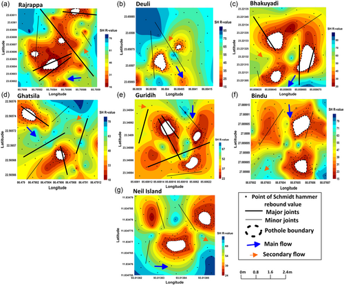
The rock strength of the channel bedrock of sample potholes and its adjoining at seven sites was measured by Schmidt hammer. We took at least 30 points for each pothole site recommended by Niedzielski et al. (2009). We considered three rebound values from each point to amplify the accuracy level, and eventually, the mean value was obtained. According to Selby (Selby, 1980), a rock strength rebound value ≥50 signifies strong rocks. A map of relative rock strength (m scale) around the sample potholes at diverse sites was prepared to classify the weathered status of the channel bedrocks. The relative rock strength maps of different pothole sites and surrounds were prepared on Surfer 14 software.
2.2 Bedrock structural examination
A systematic field measurement has been carried out at seven different sites to measure the orientation of numerous pothole axes and different micro-scale structures and joints (through m scale and km scale) in the field. The orientation of the pothole main axis and joints has been measured using a Brunton compass and at least 30 measurements have been conducted at every site. Different microscale structures, morpho-lineaments, veins, and joints have been interpreted as linear structures, and the orientation was measured based on the principal flow direction of the river. Pothole long axes and structural orientation have been shown by a rose diagram which was prepared on GeoRose software.
2.3 Morphometric indices of potholes
We examined the diverse size and shape of the potholes at seven sites applying different morphometric indices. A total of 369 (Rajrappa 101, Deuli45, Bhakuyadi 115, Ghatsila 35, Guridi 66, Bindu 6, and Neil Island 25) potholes were systematically studied at different sites from 2017 to 2022. Absolute geographical locations of potholes were marked with the help of Garmin eTrex 32x Rugged Handheld GPS Navigator, and depth (d) and radius (r) were measured by applying the graduated tape. We measured surface diameter, bottom diameter, maximum depth, or large vertical axis from the plane of the incision to the bottom of the opening for all studied sculpted forms. We also calculated the surface maximum diameter (Smax) or surface maximum horizontal length, bottom largest diameter (Bmax), or bottom largest horizontal distance, surface minimum diameter (Smin) and bottom minimum diameter (Bmin) (Table 1) (Bera et al., 2021). An exploratory assessment of potholes was carried out to study the dimensional relations between depth (d) and radius (r) for all studied sites (Table 1). Three important morphometric indices were also computed to determine the actual shape of the potholes and these indices are surface index (SI), bottom index (BI), and vertical index (VI) respectively. Surface index (SI = Smax/Smin) is defined as the relationship between maximum and minimum diameter at the surface of the opening, whereas bottom index (BI = Bmax/Bmin) describes the association between the largest and smallest diameter at the bottom of the incision. Vertical Index (VI = d/Smax/2) represents the correlation between the maximum depth (d) of the sculpted form and the maximum surface radius of the pothole (Table 1).
| Sites (locations of potholes) | Parameters | Smax (m) | Smin (m) | Bmax (m) | Bmin (m) | Depth in m (d) | Surface index (SI) | Bottom index (BI) | Vertical index (VI) | Rock type | |
|---|---|---|---|---|---|---|---|---|---|---|---|
| Max | Min | ||||||||||
| Rajrappa (Damodar River) | Radius (m) | 2.35 | 0.21 | 1.73 | 0.18 | 3.01 | 0.3 | 11.19 | 9.61 | 1.28 | Chhotanagpur granitic gneiss |
| Diameter (m) | 4.7 | 0.42 | 3.46 | 0.36 | - | - | |||||
| Mean (m) | 0.89 | 0.77 | 1.37 | ||||||||
| Standard deviation (SD) | 0.42 | 0.36 | 0.71 | ||||||||
| Deuli (Damodar River) | Radius (m) | 0.52 | 0.23 | 0.51 | 0.15 | 0.5 | 0.27 | 2.26 | 3.4 | 0.96 | Red Sandstone and Shale, mudstone |
| Diameter (m) | 1.04 | 0.46 | 1.02 | 0.3 | - | - | |||||
| Mean (m) | 0.39 | 0.35 | 0.44 | ||||||||
| Standard deviation (SD) | 0.07 | 0.08 | 0.05 | ||||||||
| Bhakuyadi (Subarnarekha River) | Radius (m) | 1.47 | 0.13 | 1.14 | 0.11 | 2.92 | 0.15 | 11.31 | 10.36 | 1.99 | Chhotanagpur granitic gneiss |
| Diameter (m) | 2.94 | 0.26 | 2.28 | 0.22 | - | - | |||||
| Mean (m) | 0.54 | 0.47 | 0.94 | ||||||||
| Standard deviation (SD) | 0.27 | 0.23 | 0.55 | ||||||||
| Ghatshila (Subarnarekha River) | Radius (m) | 1.05 | 0.17 | 0.71 | 0.14 | 1 | 0.15 | 6.18 | 5.07 | 0.95 | Tonalite gneiss, proterozoic meta sediment and Chhotanagpur granitic gneiss |
| Diameter (m) | 2.1 | 0.34 | 1.42 | 0.28 | - | - | |||||
| Mean (m) | 0.44 | 0.29 | 0.51 | ||||||||
| Standard deviation (SD) | 0.22 | 0.14 | 0.2 | ||||||||
| Guridih (Rarhu River) | Radius (m) | 1.08 | 0.18 | 1.07 | 0.17 | 2.01 | 0.49 | 6 | 6.29 | 1.86 | Chhotanagpur granitic gneiss |
| Diameter (m) | 2.16 | 0.36 | 2.14 | 0.34 | - | - | |||||
| Mean (m) | 0.48 | 0.42 | 0.94 | ||||||||
| Standard deviation (SD) | 0.19 | 0.18 | 0.33 | ||||||||
| Bindu (Jaldhaka River) | Radius (m) | 0.42 | 0.3 | 0.27 | 0.13 | 0.48 | 0.32 | 1.4 | 2.08 | 1.14 | Granitic gneiss |
| Diameter (m) | 0.84 | 0.6 | 0.54 | 0.26 | - | - | |||||
| Mean (m) | 0.37 | 0.21 | 0.41 | ||||||||
| Standard deviation (SD) | 0.04 | 0.05 | 0.06 | ||||||||
| Neil Island (Andaman Island) | Radius (m) | 0.28 | 0.1 | 0.21 | 0.06 | 0.33 | 0.14 | 2.8 | 3.5 | 1.18 | Fossiliferous limestone and Coral |
| Diameter (m) | 0.56 | 0.2 | 0.42 | 0.12 | - | - | |||||
| Mean (m) | 0.17 | 0.12 | 0.21 | ||||||||
| Standard deviation (SD) | 0.05 | 0.04 | 0.05 | ||||||||
2.4 Statistical analysis
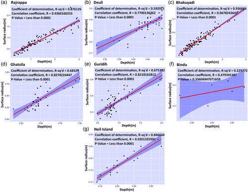
To determine the relationship between pothole depth and radius at the seven sample sites, r value (Pearson product movement method), r2 value (correlation of determination), residual mean square, and standard error (SE) have been determined (Table 2). One more descriptive statistical technique coefficient of variation (CV) was also applied to comprehend the consistency of dynamic growth of potholes (surface and bottom diameter and depth) (Table 2, Figure 3).
| Sites (locations of potholes) | Parameters | Mean (m) | Standard Error | Median (m) | Mode (m) | Standard deviation | Sample variation | kurtosis | Skewness | Range (m) | Minimum (m) | Maximum (m) | Sum (m) | No. of pothole | Coefficient of variation |
|---|---|---|---|---|---|---|---|---|---|---|---|---|---|---|---|
| Rajrappa (Damodar River) | Surface Radius | 0.89 | 0.04 | 0.81 | 0.84 | 0.42 | 0.17 | 0.56 | 0.76 | 2.14 | 0.21 | 2.35 | 89.42 | 101 | 46.95 |
| Bottom Radius | 0.77 | 0.04 | 0.7 | 0.68 | 0.36 | 0.13 | −0.14 | 0.6 | 1.55 | 0.18 | 1.73 | 77.87 | 101 | 47.29 | |
| Depth | 1.37 | 0.07 | 1.17 | 0.65 | 0.71 | 0.51 | −0.36 | 0.79 | 2.71 | 0.3 | 3.01 | 138.31 | 101 | 52.14 | |
| Deuli (Damodar River) | Surface Radius | 0.39 | 0.01 | 0.4 | 0.4 | 0.07 | 0.01 | 0.22 | −0.76 | 0.29 | 0.23 | 0.52 | 17.77 | 45 | 18.15 |
| Bottom Radius | 0.35 | 0.01 | 0.36 | 0.38 | 0.08 | 0.01 | 0.3 | −0.67 | 0.36 | 0.15 | 0.51 | 15.78 | 45 | 23.44 | |
| Depth | 0.44 | 0.01 | 0.45 | 0.45 | 0.05 | 0 | 2.3 | −1.45 | 0.23 | 0.27 | 0.5 | 19.96 | 45 | 11.66 | |
| Bhakuyadi (Subarnarekha River) | Surface Radius | 0.54 | 0.02 | 0.5 | 0.54 | 0.27 | 0.07 | 1.17 | 0.99 | 1.34 | 0.13 | 1.47 | 62.28 | 115 | 49.41 |
| Bottom Radius | 0.47 | 0.02 | 0.44 | 0.12 | 0.23 | 0.05 | 0.06 | 0.65 | 1.03 | 0.11 | 1.14 | 54 | 115 | 48.87 | |
| Depth | 0.94 | 0.05 | 0.82 | 0.55 | 0.55 | 0.3 | 1.57 | 1.16 | 2.77 | 0.15 | 2.92 | 108.2 | 115 | 58.08 | |
| Ghatsila (Subarnarekha River) | Surface Radius | 0.44 | 0.04 | 0.38 | 0.46 | 0.22 | 0.05 | 0.13 | 0.9 | 0.88 | 0.17 | 1.05 | 15.46 | 35 | 50.77 |
| Bottom Radius | 0.29 | 0.02 | 0.26 | 0.23 | 0.14 | 0.02 | 2.92 | 1.67 | 0.57 | 0.14 | 0.71 | 10.29 | 35 | 46.73 | |
| Depth | 0.51 | 0.03 | 0.46 | 0.47 | 0.2 | 0.04 | 1.42 | 1.28 | 0.85 | 0.15 | 1 | 17.93 | 35 | 38.19 | |
| Guridih (Rarhu River) | Surface Radius | 0.48 | 0.02 | 0.45 | 0.38 | 0.19 | 0.03 | 0.84 | 0.9 | 0.9 | 0.18 | 1.08 | 31.66 | 66 | 38.57 |
| Bottom Radius | 0.42 | 0.02 | 0.39 | 0.49 | 0.18 | 0.03 | 1.77 | 1.15 | 0.9 | 0.17 | 1.07 | 27.7 | 66 | 42.96 | |
| Depth | 0.94 | 0.04 | 0.84 | 0.89 | 0.33 | 0.11 | 3.95 | 1.96 | 1.52 | 0.49 | 2.01 | 62.28 | 66 | 34.67 | |
| Bindu (Jaldhaka River) | Surface Radius | 0.37 | 0.02 | 0.38 | 0 | 0.04 | 0 | 0.71 | −0.92 | 0.12 | 0.3 | 0.42 | 2.23 | 6 | 11.47 |
| Bottom Radius | 0.21 | 0.02 | 0.22 | 0.22 | 0.05 | 0 | 1.31 | −0.91 | 0.14 | 0.13 | 0.27 | 1.27 | 6 | 22.64 | |
| Depth | 0.41 | 0.02 | 0.42 | 0 | 0.06 | 0 | 0.52 | −0.77 | 0.16 | 0.32 | 0.48 | 2.48 | 6 | 13.66 | |
| Neil Island (Laksman Beach) | Surface Radius | 0.17 | 0.01 | 0.17 | 0.19 | 0.05 | 0 | −0.21 | 0.52 | 0.18 | 0.1 | 0.28 | 4.34 | 25 | 26.86 |
| Bottom Radius | 0.12 | 0.01 | 0.11 | 0.09 | 0.04 | 0 | 0.07 | 0.79 | 0.15 | 0.06 | 0.21 | 2.96 | 25 | 32.04 | |
| Depth | 0.21 | 0.01 | 0.2 | 0.2 | 0.05 | 0 | 0.84 | 1.04 | 0.19 | 0.14 | 0.33 | 5.19 | 25 | 23.77 |
2.5 Measurement of the size of tools and grinders
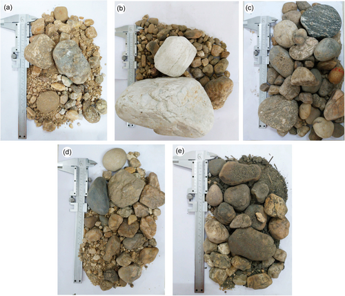
Rounded granules, pebbles, and cobbles play a significant role as tools and grinders to abrade pothole sides and floors. During the field visit, we observed that big- diameter deep potholes have a high capacity to keep tools and grinders while small potholes can hold only tools on their floors. In most of the cases, it has been noticed that there were no sediments or clasts within the small potholes whereas deep tapered shaped potholes retain occasionally sediments in their bottoms. We also studied the occupancy rate of sediments, tools and grinders for studied potholes at seven different sites. We collected tools and grinders from three sample potholes (big, medium, and small-sized potholes concerning diameter and depth) at each site by plastic sample bags (it is a very common method to collect tools and grinders) and the size of tools and grinders was measured using Vernier caliper according to Wentworth grade scale (Figure 4).
3 RESULTS
3.1 Channel bedrock strength examination
The mean rebound values of the Schmidt hammer at different studied sites signify diverse rock strength. The measurements could not be obtained in the sculpted zone (white- colored area on the map) mostly because the potholes were covered by water with tools and grinders. The shade variant of the relative rock strength map shows deep red to deep blue (Figure 5). A deep red shade represents weak rock strength(SH R- value 20–40) while deep blue demonstrates strong rock strength (Table 3).
| Reading | Rajrappa | Deuli | Bhakuyadi | Ghatsila | Guridih | Bindu | Neil Island |
|---|---|---|---|---|---|---|---|
| Mean value (Schmidt hammer) | 39.96 | 50.16 | 39.83 | 45.16 | 38.08 | 41.46 | 52.16 |
| Reading (Schmidt hammer) | 34 | 53 | 33 | 43 | 30 | 35 | 57 |
| No. of studied pothole | 101 | 45 | 115 | 35 | 66 | 6 | 25 |
| Rock types | Chhotanagpur granitic gneiss | Red Sandstone, Shale, and Mudstone | Chhotanagpur granitic gneiss | Tonalite gneiss, Proterozoic meta sediment and Chhotanagpur granitic gneiss | Chhotanagpur granitic gneiss | Granitic gneiss | Fossiliferous limestone and Coral |
In the case of site Rajrappa, potholes grow up on granite gneiss bedrock type. The mean rebound value of the Rajrappa site indicates (39.96) low rock strength (fragile rock). Similarly, in Guridih, Bhakuyadi, and Ghatsila sites, potholes develop on Precambrian Chhotanagpur granite gneiss and tonalite gneiss (at Ghatsila), whereas the mean Schmidt hammer rebound values at three sites (38.08, 39.83, and 45.16) specify weak rock strength (Table 3). In the case of Deulisite, small sculpted forms grow on red sandstone, shale, and mudstone, while the mean rebound value (50.16) shows high bedrock strength. The mean rebound value (41.46) of potholes on granite gneiss at Bindu indicates weak rock mass strength. Similarly, the mean rebound value (52.16) of marine beach (Laxmanpur beach, Neil Island) potholes indicates strong rock strength, and these potholes have been developed on fossiliferous limestone. Rajrappa, Bhakuyadi, and Guridih studied sites that give diverse Schmidt hammer rebound values, but still, there was no existence of potholes where ranges of rebound values vary between 20 and 30. The results of channel bedrock strength offer multiple values regarding fragile and strong bedrock mass but this information does not make any scientific conclusion regarding pothole development. This result showed that rock strength is not the only principal regulating factor for the development of such channel bed sculpted form. Multiple channel bedrock types (at seven studied sites) with macro to micro surface and subsurface litho-structures give such different rebound values. Potholes are lengthened in the direction of lineament axes and virtually parallel to the river flow direction (Figure 5a). In some cases, Schmidt hammer rebound values confirm the appearance of subsurface dominant weak litho structures of bedrock channels (Figure 5c). This result also indicates the coalescence of micro fractures or joints instead of a single structural attribute.
3.2 Analysis of the morphology of potholes
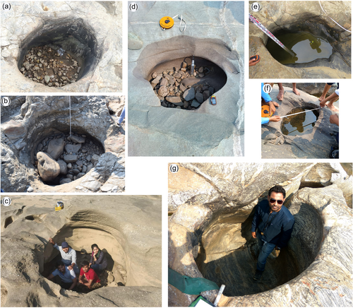
Different morphometric and statistical parameters were used to analyze the dynamic growth and shape and size of streambed and marine potholes. In the case of the Rajrappa site, in the river Damodar (n = 101), the biggest surface (Smax) and bottom diameters (Bmax) show 4.7 and 3.46 m, whereas the smallest surface and bottom diameters (Smin and Bmin) indicate 0.42 and 0.36 m, respectively. The highest vertical depth was 3.01 m, while the average depth was 1.37 m at the Rajrappa site. Surface, bottom, and vertical indexes (SI, BI, and VI) are 11.19, 9.61, and 1.28, respectively. Here, the maximum surface and bottom diameters (Smax = 4.7 m and Bmax = 3.46 m) are greater than the maximum depth (dmax = 3.01 m). Applying different morphometric parameters (for the Rajrappa site), it was found that 66 potholes are cylindrical, 19 elliptical, and 15 elongated forms. Truncation and amalgamation processes also control the shape and form of potholes, which is why few sites potholes do not maintain ideal shape. Subarnarekha riverbed at Bhakuyadi site has 2.94 m largest surface diameter (Smax) and 2.28 m largest bottom diameter (Bmax) while minimum surface and bottom diameters (Smin and Bmin) of potholes are 0.26 and 0.22 m, respectively. The maximum depth of the sculpted form at Bhakuyadi was 2.92 m, while the mean depth was 0.94 m. The surface, bottom, and vertical indexes (SI, BI, and VI) of studied potholes are 11.31, 10.36, and 1.99, correspondingly. Out of 115 studied potholes, the shape of 76 potholes was cylindrical, 14 in elliptical and 25 in elongated types. For the Guridih site (RarhuRiver), the maximum surface and bottom diameters were 2.16 and 2.14 m, whereas minimum surface and bottom diameters recorded 0.36 and 0.34 m, respectively. Consequently, the highest perpendicular depth was recorded at 2.01 m, while the value of the mean shows 0.94 m. Besides, surface index, bottom index, and vertical index showed 6.00, 6.29, and 1.86, respectively, and morphometric indexes and field observation demonstrated that 35 sculpted forms are cylindrical, 18 elliptical, and 13 elongated forms. In the case of Ghatsila (Subarnarekha River), Smax and Bmax are 2.1 and 1.42 m, while Smin and Bmin are 0.34 and 0.28 m, respectively. Here, the value of maximum depth was measured at 1 m while the mean value was 0.51 m correspondingly. In addition, SI, BI, and VI showed 6.18, 5.07, and 0.95, respectively. Morphometric indexes revealed 16 in cylindrical, 10 in elliptical, and 9 in elongated shape. For the Deuli site (Damodar River), Smax and Bmax were 1.04 and 1.02 m, whereas Smin and Bmin showed 0.46 and 0.30 m, respectively. Consequently, the value of d was 0.50 m while the mean value of d was 0.44, and it is stated that the difference between the two values is minimal. Moreover, SI, BI, and VI were computed at 2.26, 3.40, and 0.96, respectively. Morphometric study showed that 31 potholes are cylindrical and 14 in elliptical shapes. Bindu site (Jaldhaka river) revealed that Smax and Bmax are 0.84 and 0.54 m, whereas Smin and Bmin show 0.60 and 0.26 m, respectively. At the Bindu site, the value of d was measured at 0.48 m, while the mean value was 0.41 m. Here, SI, BI, and VI showed 1.40, 2.08, and 1.14, respectively. The morphometric study revealed that 5 potholes are cylindrical and 1 pothole is in an elliptical shape (Figure 6). In the case of Laxmanpur Beach (Neil Island), Smax and Bmax are 0.56 and 0.42 m, whereas Smin and Bmin indicate 0.20 and 0.12 m, respectively. Here, the value of d was measured at 0.33 m while the mean value was 0.21 m, respectively. SI, BI, and VI are illustrated as 2.80, 3.50, and 1.18, respectively. Here, 16 potholes are cylindrical, and 9 in elliptical shapes. Significant variations of Smax, Bmax, Smin, Bmin, and d have been found at Rajrappa, Bhakuyadi, Guridih, and Ghatsila sites, whereas Deuli, Bindu, and Laxmanpur Beach showed less variation among the variables.
3.3 Bedrock multiscale structural analysis
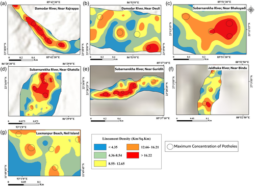
Bedrock structural measurements (joints, fractures, veins, etc.) at seven studied sites disclosed the structural diversity that could control the dynamic growth of potholes. In the case of the Rajrappa site (Damodar River), 90% of structural measurements (52 measurements) are joints, and the rest 10% are fractures. This site shows NW to SE trending major lineament axes while maximum pothole axes display W to E and least NW to SE trending direction. Here, most of the potholes are broadly confined to a very high (≥16.22 km/sq.km) lineament density zone (Figure 7). For river Subarnarekha (Bhakuyadi site), 70% of structures correspond to joints, and the remaining are fractures and veins. In this site, major lineament axes show SW to NE direction while dominant pothole long axes exhibit NW to SE trend. Moreover, dominant potholes on the channel bed present very high lineament density (≥16.22 km/sq.km) and consequently, few sculpted forms also developed in high lineament density zones (12.66 to 16.21 km/sq. km). At the Guridih site, 88% of bedrock structures correspond to joints, and the rest are fractures, bedding, and veins that have been exposed on Precambrian Chhotanagpur granite gneiss. This site reveals NE to SW trending major lineaments axes, whereas primary dominant pothole axes are NE to SW, and secondary pothole axes show NW to SE direction. Most of the potholes have been confined in very high lineament density zones (≥16.22 km/sq.km). In the three mentioned sites, several potholes occur at junctions of conjugate shear joints/fractures. Coalescence of potholes also develops along the major lineament axes or principal flow direction of the channel. Shapes of potholes systematically change due to multidirectional bedrock structures like joint fractures, bedding and veins, particularly for these sites. For the channel bed of Subarnarekha at Ghatsila, 91% of structural measurements get nearer to joints, and the remaining are fractures, bedding, and veins. This site exhibits N to S major lineament axes direction whereas potholes are found in very high (≥16.22 km/sq.km) to high (12.66 to 16.21 km/sq.km) lineament density zones on tonalite gneiss bedrock. Furthermore, most of the potholes long axes demonstrate NE to SW direction and secondary potholes long axes show NW to SE direction. In the case of the Deuli site (river Damodar), structural measurements approach fractures, laminations, and veins exposed on red sandstone, shale, and mudstone bedrock channel. These bedrocks have low (4.36 to 8.54 km/sq.km) to moderate (8.55 to 12.65 km/sq.km) lineament density and major lineament axes indicate W to E direction. In addition, pothole long axes represent W to E, NW to SE, and NE to SW directions. Here, minor bedrock sculpted forms have no such specific long axes. For river, Jaldhaka within the Lesser Himalayan range (at Bindu site), lineament major axes specify W to E, N to S, and NE to SW directions with moderate lineament density (8.55 to 12.65 km/sq.km) while dominant pothole long axes denote NE to SW, and minor pothole axes show W to E direction. In the case of Laxmanpur Beach, Neil Island (Andaman Islands), 98% of exposed marine beach structural measurements specify fractures and nodules. This site is characterized by fossiliferous limestone, which is composed of tiny fossils with skin fragments and diverse fossilized debris. Major lineament axes of fossiliferous limestone show NW to SE direction while dominant pothole long axes indicate SW to NE and secondary axes show NW to SE direction (Figure 8). This marine beach is also characterized by low (4.36 to 8.54 km/sq.km) to moderate (8.55 to 12.65 km/sq.km) lineament density. Most of the recorded bedrock structures, such as joints and fractures are vertical and near vertical. Except for three sites (Deuli, Bindu, and Laxmanpur Beach), most of the potholes have been elongated in the direction of structural weakness (joints and fractures), which are virtually parallel to the river flow direction. In a few sites, it has been noticed that sub-surface joints and fractures appear to be detected through Schmidt hammer rebound values (Figure 5).
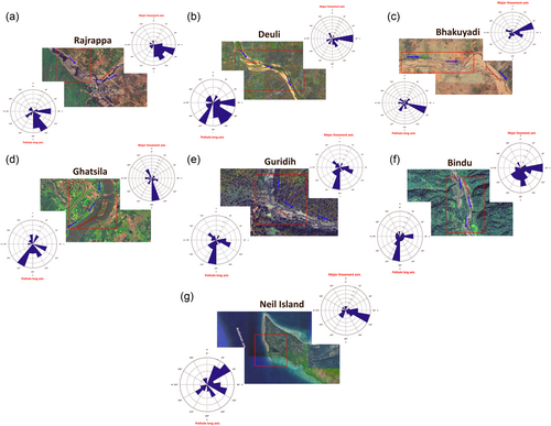
3.4 Analysis of the size of tools and grinders
It was very difficult to measure the size and nature of all tools, grinders, and sediments of all the potholes. To get the overall idea of the dynamic growth of potholes, three sample potholes were chosen from each study site and pebble size was analyzed by Vernier caliper. The occupancy rates of sediments, tools and grinders within potholes were 54% (Rajrappa site), 52% (Bhakuyadi site), 45% (Guridih site), and 40% (Ghatsila site) for big (>2 m diameter and depth) and medium (1–2 m diameter and depth) sized diameter depth ratio potholes (Alexander, 1932, Bera et al., 2021) while potholes occupy 10% sediments, tools and grinders at Deuli, Bindu and Laxmanpur Beach sites. In the sculpted forms that occupied pebbles and cobbles, in general, diameter depth ratios were found greater than 0.9. Extensive field observations showed that in most of the cases, the shapes of the grinders and tools in potholes (those potholes which are found along the inner channel) were identified as spherical or ovoid forms, whereas oblique pebbles were occupied within the potholes which are situated far away from the main flow path. In the case of the Rajrappa site, the pebble size analysis showed the percentage and size of pebbles (15%, ≤6.4 cm), cobbles (64%, 6.4–25.6 cm), and boulders (21%, ≥25.6 cm) within sample potholes whereas at Bhakuyadi site, pebbles, cobbles, and boulders revealed the proportions of 11%, 64%, and 25%, respectively. At the Guridih site, pebbles, cobbles, and boulders showed percentages of 14%, 60%, and 26%, respectively, while at Ghatsilasite; pebbles, cobbles, and boulders have percentages of 24%, 51%, and 25%, respectively. The rest of the sites have no such grinders but observed clasts and tools are not well sorted.
3.5 Statistical analysis of different parameters
Depth-Radius relation shows strong positive correlation for all the sites except Bindu (n = 06, 0.479345387) such as Rajrappa (n = 101, R = 0.9360160255), Bhakuyadi (n = 115, R = 0.9678243642), Guridih (n = 66, R = 0.8218162812), Ghatsila (n = 35, R = 0.8278224447), Deuli (n = 45, R = 0.7700136362), and Neil Island (n = 25, R = 0.9201325991) respectively. Maximum depth (3.01 m), surface (2.35 m), and bottom radius (1.73 m) are measured at the Rajrappa site. The mean depth, surface, and bottom radius of all pothole sites except Deuli and Bindu exhibit consistently a positively skewed distribution, while kurtosis values (for depth, surface, and bottom radius) for all sites indicate less than 3 except Guridih (Figure 6). The frequency curve is flat-topped, and the distribution is called platy-kurtic, but the depth value of Guridih shows a lepto-kurtic distribution. We have also observed that the size of the biggest grinding stone was 10 cm and the pothole exhibits a strong positive correlation with depth, and particularly the size of the grinding stone (except Bindu and Deuli and Neil Island).
4 DISCUSSION
Initiation and development of river channel potholes largely depend on bedrock properties, supply of tools, and river hydrology. Spatial, temporal, and seasonal variations of these above-mentioned factors are greatly controlled by climate change and tectonic activities. Cylindrical, elliptical, and circular-shaped big diameter-depth ratio potholes have been developed on the channel bed of river Damodar (Rajrappa site), Subarnarekha (Bhakuyadi and Ghatsila sites) and Rarhu (Guridih site) due to high (12.66 to 16.21 km/sq.km) and very high lineament density (≥16.22 km/sq.km). Multiple structural units like joints, fractures, veins, xenolith and dikes have been exposed on bedrock channels at studied sites. In the case of the Rajrappa and Bhakuyadi sites, most of the potholes developed on conjugate shear joints or intersections of joints. Here, potholes are lengthened in the direction of weakness of joints which are almost parallel to flow direction. This study showed that largely the pothole axes are mostly aligned to parallel to the flow direction of the river. Alignments of a few potholes are not connected with joints, while the Schmidt hammer rebound value signifies hidden joints or fractures of bedrock channels (Viles et al., 2011). Schmidt hammer rebound value depends on the elastic properties of the surface mass where the hammer shocks. This systematic measurement of bedrock strength at each study site showed structural heterogeneities that could control the growth and development of potholes. Growth and enlargement of potholes, particularly at Deuli, Bindu, and Laxmanpur Beach sites, are comparatively restricted because of less structural imprints. The orientation of primary joints and potholes' main axes was towards the principal flow directions of the rivers. Data on Schmidt hammer rebound value provide adequate information regarding rock strength or weathering rate of rock mass and its quality, but it is not the only regulating factor for the development of potholes (Černá & Engel, 2011).
We identified that isolated potholes, which mostly developed on the shoulder of the inner channel but coalesced potholes, are concentrated in the deeper channel section because of the highest flow over the most long-standing period. Johnson and Whipple (2007) experimented that channel bed potholes may also grow impulsively without major structural imprints while they develop only due to the interaction between tools or grinders and fluid. The typology of potholes has also been studied by applying morphometric indices particularly to comprehend the shape and size in lithological and structural diversity. The horizontal aperture of the individual potholes is circular, cylindrical, and elliptical, whereas Ortega et al., 2014 assigned names like a teardrop, kidney, lateral truncated, confined and coalesced, etc. Grooves, furrows, flutes, or scallops were noticed on the smoothly polished walls of the potholes and along the joints, fractures, and veins of the bedrock, particularly at the Rajrappa and Bhakuyadi sites. Mechanical (block disintegration, granular disintegration) and chemical weathering (hydration) take place on the walls of potholes due to periodic wetting and drying. Low-velocity flow and discharge can assist in generating such channel bed micro-features, which supply clasts and sediments for the initial growth and development of shallow potholes (Figure 9). It has also been observed that small potholes show concave floors, while big circular and elliptical potholes have slightly convex floors. Sometimes, large potholes have a central hump or boss (Ji et al., 2018) around which a spiraling vortex (Figure 10) gets high energy through centripetal acceleration, and tools or grinders can gradually erode the side walls of potholes (Alexander, 1932; Bera et al., 2021; Hancock et al., 1998; Pelletier et al., 2015). In both the sites like Rajrappa(in the river Damodar) and Bhakuyadi (Subarnarekha River), the truncated imperfect-shaped chain of potholes have been developed along the elongated trough or horizontal furrows. Big potholes were created through the amalgamation of small potholes where larger r but small d. It has been found at Rajrappa, Bhakuyadi, Guridih, and Ghatsila sites. The fragile bedrocks are easily weathered and disintegrated and as a result, the upper portion has been removed during high velocity-discharge flood events. The truncation process also destroys the potholed layers and it gradually removes the bed (Bera et al., 2021; Springer et al., 2006; Whipple et al., 2000). Thus, new pothole starts to grow on the removed rocky channel platform.
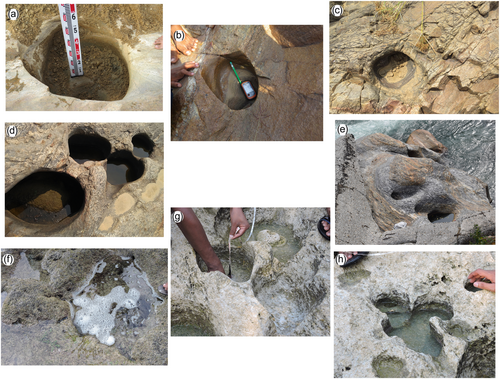
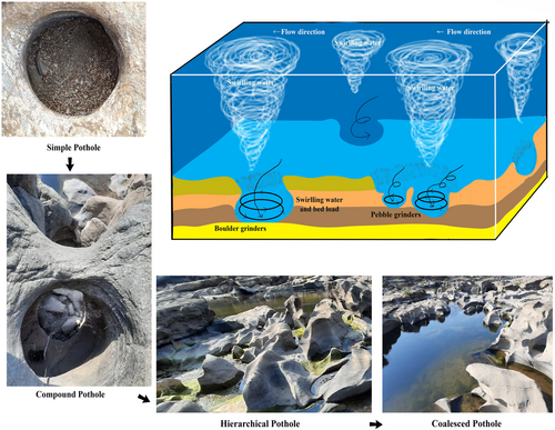
This pothole truncation mechanism is reiterated again and again. Consequently, it accelerates the gradual development of canyons and gorges. Marine beach potholes (In the case of Laxmanpurbeach, Neil Island) develop through coastal erosion processes like marine transgression and regression. Most of the Laxmanpur beach potholes are circular while few potholes get elliptical due to initiation at minor joints on fossiliferous limestone-exposed rocky beach. These small shallow-depth marine beach potholes occupy very low amounts of sediments and clasts. In most cases, the pothole's floor is completely absent of tools and grinders, whereas at the Bindu site (very short stretch) in river Jaldhakawithin the Lesser Himalayan range was completely bedload free that situation may prefer to develop a few small shallow potholes on a hard channel platform. Ortega et al. (2014) established that the different typologies of potholes are initiated by primary and secondary channel bed joints, fractures, dikes, and veins. They interpreted that tear-drop-shaped pothole develops along the single structural imprint that is parallel to the principal or secondary river flow direction. Kidney-shaped pothole development is controlled by the orientation of both the primary and secondary joints. Sometimes, complicated pothole shape is formed due to the presence of dikes or xenoliths, which create a barrier for normal growth and development of potholes whereas a new track is also followed when the barrier is crossed (during high velocity-discharge flood situation) (Figure 11) (Bera et al., 2021). A pothole in a pothole is also developed when two potholes are overlapped along the horizontal joints, and after amalgamation, a pothole is expanded, and a smaller inner sculpted form is created (Bera et al., 2021). It has been observed that river potholes display a higher diameter-depth ratio compared with marine beach potholes because rivers can offer higher erosion potential than marine waves. The marine waves apply small and moderate-sized grinding tools to pierce beach rock potholes, while river and mostly devastating floods transport diverse-sized tools and grinders depending on the stream hydraulic power to drill the bedrock. In the case of streambed potholes, fluid flow is nearly unidirectional, while wave-generated currents in marine beach potholes are very complex due to alternately being exposed to wave-generated currents, backwash, tidal bore, and tsunamigenic forces. These driving forces give the energy to whirl the clasts and tools within the depressions or in the intersections of joints and fractures.
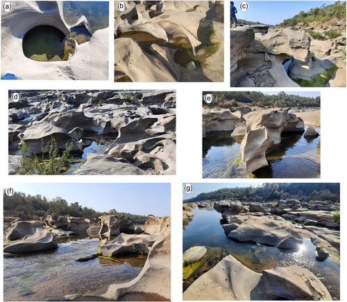
Here, the depth and radius relationship of potholes at all studied sites shows a strong positive correlation except the Bindu site (moderate positive correlation) because the widening and deepening of potholes are proportionally increasing due to suitable bedrock properties, supply of tools, and hydrological environment. The high diameter-depth ratio of potholes at Rajrappa, Bhakuyadi, Guridih, and Ghatsila was due to available big diameter sizes grinders, multi-structural units, and high channel gradient, while the low diameter-depth ratio at Deuli, Bindu, and Laxmanpur beach is mainly because of minor bedrock structures, and tools or sediments. Gouge and plunge pool-like potholes are formed at Rajrappa, Bhakuyadi, and Guridih sites, and these carry larger grinding stones, whereas the rate of deepening is faster than widening. Mostly depth, surface radius, and bottom radius for all studied sites display persistently a positive skewed frequency distribution. The average surface radius, bottom radius, and depth of all sites show platy-kurtic, while only at the Guridih site; depth shows leptokurtic distribution due to coalescence, amalgamation, and truncation of potholes.
5 CONCLUSION
A pothole is a significant type of fluvial erosional sculpted form in bedrock river channels and marine beaches. The study of pothole dynamics will be motivated by scholars for the inventory and evaluation of geo-heritage sustainability. Pothole makes a unique microenvironment or habitat biodiversity for different aquatic species and micro-organisms. Moreover, pothole and pothole-created canyons of sculpted bedrock have provided an attractive tourist destination, natural wonders, esthetic enjoyment, and very important sites for geomorphology and geological research (landform evolution and climate change). Understanding and data of the pothole depth-diameter relationship are highly required for the different river hydraulic and engineering projects such as excavation and dredging, bridge, culvert, and dam or barrage construction. Consecutively, it is essential to calculate the cost of rock excavation or dredging, particularly for the mechanical strength of the bedrock river channel and its stability.
Here, coalescence, along with amalgamation and truncation restrict the vertical depth threshold (VDT) of potholes. VDT is restricted within 3 m for Rajrappa (Damodar River), Bhakuyadi (Subarnarekha River), and Guridih(Rarhu River) sites. Truncation and amalgamation mechanisms are the principal causes of pothole decay, and it accelerates to create canyons and gorges along the primary flow and joint directions of the river, particularly at Rajrappa (Damodar River), Bhakuyadi (Subarnarekha River), and Guridih (RarhuRiver) sites. Here, the progressive growth of pothole depth-diameter is regulated by existing bedrock structures, tools or grinders, and a monsoonal high-velocity bank full discharge while deepening and widening of the pothole is comparatively slow at Bindu, Deuli, and marine beach Neil Island due to fewer structures and tools or grinders. The small stretch canyons and gorge-like features (bedrock incision) are probably formed at Rajrappa, Bhakuyadi, and Guridih sites due to the cyclic truncation process. Sometimes, complex pothole shape is created due to the existence of dikes or xenoliths, which make a barrier for the normal growth and development of potholes, whereas a new path is also followed when an obstruction is crossed (during high velocity-discharge flood situations). Big potholes are expanded in the direction of lineament axes and almost parallel to the river flow direction. Shapes of potholes steadily alter due to multidimensional structural existence, mostly for these sites. A pothole in a pothole is also found when two potholes are overlapped along the parallel joints, and after amalgamation, a pothole is stretched, and a smaller inner sculpted form is formed. Few cases, Schmidt hammer rebound values prove the appearance of subsurface dominant weak litho-structures on bedrock channels. This result also specifies the coalescence of micro-fractures instead of a single structural attribute. Correspondingly, it is also stated that there was no such clear connection between the growth of potholes and the structural weakness of bedrock channels. This study will show the multiple future research directions, and Govt. should provide funds for advanced research and development for the application of sustainable river engineering work and management.
ACKNOWLEDGMENTS
This research received no specific grant from any funding agency in the public, commercial, or not-for-profit sectors.
ETHICS STATEMENT
None declared.
Open Research
DATA AVAILABILITY STATEMENT
Landsat satellite and DEM datasets are available from the U.S. Geological Survey portal, https://glovis.usgs.gov/. Lithological and structural datasets are available from the Geological Survey of India, https://www.gsi.gov.in/webcenter/portal/OCBIS. Lineament direction has been analyzed through GeoRose software, available from https://www.yongtechnology.com/georose/. Statistical analysis has been done using R software, available from https://www.r-project.org/.


