Check dams on China's Loess Plateau: An overview
Abstract
Check dams are widely constructed on China's Loess Plateau, which had a total number of 58,776 by the end of 2019. Great achievements in check dam construction have been gained regarding the economic and environmental impacts. This study reviews the remarkable benefits of check dams on the land reclamation and environmental improvement on the Loess Plateau, and sediment reduction entering the Yellow River. However, the flood incidents on check dams have been frequently reported for the past decades, which has attracted more attention in the context of climate change and extreme rainfall events recently. Advances in the flood migration techniques achieved by the research group led by the first author have been highlighted to migrate the breach risk of check dams due to floods. The “family tree method” has been proposed to determine the survival status and critical rainfall threshold of each check dam in the complicated dam system. An updated dam breach flood evaluation framework and the corresponding numerical algorithm (i.e., DB-IWHR) have been developed. Moreover, innovative types of water-release facilities for check dams, including geobag stepped spillway and prestressed concrete cylinder pipe in the underlying conduit, have been proposed and developed. Finally, the perspectives concerning the check dam construction on the Loess Plateau have been put forward.
1 INTRODUCTION
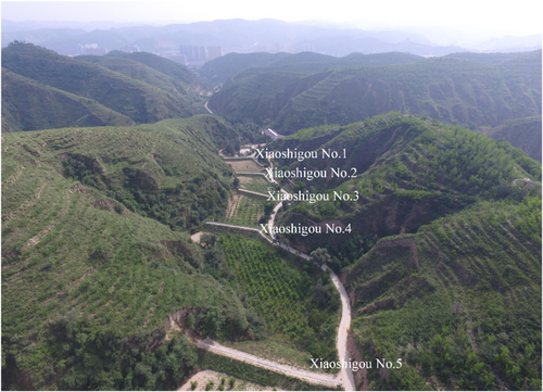
The Loess Plateau in China is characterized by numerous gullies and erosion channels. Intense rainfall causes severe soil erosion, leading to the loss of forests and grasslands, leading to an extremely fragile ecological environment and impoverished living conditions for local residents (Ai & Yang, 2018). Check dams are widespread soil and water conservation structures that have been created by the inhabitants of the Loess Plateau dating to the Ming Dynasty (Wang et al., 2011a; Xu et al., 2004). Figure 1 shows a typical check dam system constructed in the small watershed of Xindiangou, which consists of a series of barriers that retain runoff and sediment in the gully during flood seasons, transforming the gully into arable land. The side slopes of the gully, originally used for agriculture, can then be abandoned and reforested, leading to greening of the entire area.
Since olden times, check dams have been widely used throughout the world. Abbasi et al. (2019) provided a comprehensive review of the use of check dams for soil and water management in different continents, including Asia, Europe, North America, and Africa. It has been proven that check dams are effective as a measure for gully preservation in terms of land development, environmental improvement, agricultural production, enhancement of gully stabilities and mitigating intensive flood (Addisie et al., 2016; Lucas-Borja et al., 2021; Norman et al., 2016; Tian et al., 2013; Wang et al., 2021). However, the development of check dams on the Loess Plateau is notable for their large-scale construction, strategic goals, and sustained efforts for soil and water conservation (Chen, 2022; Guo et al., 2021; Wang et al., 2011a; Zhang et al., 2022).
1.1 Soil and water conservation on the Loess Plateau
Soil erosion is a prime concern for environmental protection on the Loess Plateau which is located in the upper and middle reaches of the Yellow River and spans an area of 640,600 km2. Due to the high erodibility of loess and the incision of the Yellow River and its tributaries, the Loess Plateau is one of the most severely-eroded soil regions in the world (Wang et al., 2021). According to the Soil and Water Conservation Bulletin of the Yellow River Basin (YRCC of CMWR Yellow River Conservancy Commission of Ministry of Water Resources of People's Republic of China, 2024), the area of soil erosion on the Loess Plateau is 223,600 km2, including a water-induced erosion area of 170,200 km2 and wind-induced erosion area of 53,400 km2. The classification of the water-driven erosion intensity on the Loess Plateau is shown in Table 1. Soil and water conservation practices have been extensively conducted on the Loess Plateau since the 1950s, mainly including engineering measures (e.g., construction of check dams) and biological methods (e.g., ecological restoration) (Wen & Zhen, 2020).
| Total | Light | Moderate | Intensive | Very intensive | Severe | |
|---|---|---|---|---|---|---|
| Area (104 km2) | 17.02 | 10.06 | 4.48 | 1.56 | 0.77 | 0.15 |
| Percentage (%) | 100 | 59.11 | 26.32 | 9.17 | 4.52 | 0.88 |
1.2 Development of check dams
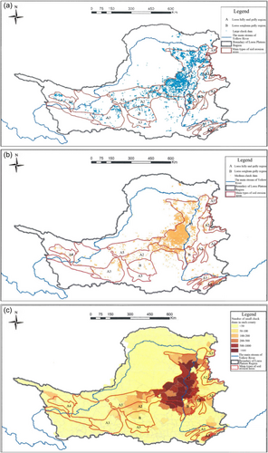
The history of check dam construction on the Loess Plateau can be traced back to the Ming Dynasty in the 16th century (Ai & Yang, 2018; Wei et al., 2017). These ancestors secured a stable grain supply through “damming and reclaiming” (Chen et al., 2020). Concurrently, many gullies were transformed into terraced croplands, which significantly curbed soil erosion (Dang et al., 2020; Liu et al., 2014). By the end of 2019, there were 58,776 check dams on the Loess Plateau (CMWR Ministry of Water Resources of People's Republic of China, 2020a; Liu & Wang, 2020). Table 2 and Figure 2 show the distribution of check dams on the Loess Plateau.
| Type of check dam | Large check dam | Medium check dam | Small check dam | Total |
|---|---|---|---|---|
| Coarse sediment concentrated yield zone | 1104 | 3680 | 7288 | 12,072 |
| High and coarse sediment yield zone | 3174 | 9652 | 28,050 | 40,876 |
| High sediment yield zone | 4930 | 11,269 | 36,042 | 52,241 |
| Loess Plateau | 5905 | 12,169 | 40,702 | 58,776 |
1.3 Impact of inadequate flood control facilities
Check dams, particularly those built by local residents on the Loess Plateau before 1986, were typically designed and constructed without sufficient flood-control facilities. Most of these check dams do not contain spillways (Liu & Wang, 2020; Yu et al., 2019). Some large check dams have masonry spillways built on soil foundations without adequate bearing capacity. Horizontal concrete pipes buried in the dam for releasing the reservoir water have also been built on soil foundations, which have been designed to be unpressurized, being fragile against external hydraulic impacts. Damage or destruction of check dams by floods has been frequently reported, especially after extreme rainfall events that have been occurring more frequently in the Loess Plateau in recent years owing to climate change (e.g., Dang et al., 2019; Li et al., 2014; Yang et al., 2020). For example, 119 out of 217 check dams were damaged by a flood in the Jiuyuangou watershed on the northern Loess Plateau. This issue has been reviewed in detail in Section 3.
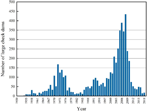
Debates on the pros and cons of building check dams on the Loess Plateau have been a long-lasting hot topic which has remarkably influenced the decision-making process for planning and constructing check dams on it. There were two periods of check dam construction surges: from 1968 to 1976 and from 2000 to 2009 (Chen et al., 2020; Liu et al., 2018), refer to Figure 3. Since 2009, there has been a long period of inactivity in terms of constructing check dams.
This study provides an overview of the various aspects of check dam construction in terms of its economic and environmental benefits and the countermeasures for dam safety controls over the past several decades, along with an outlook on its future development. Most of the references cited in this paper are from Chinese journals. They are readily accessible through web databases, such as CNKI. The digital object identifiers of the cited references, whenever available, have also been provided in the references section.
2 ACHIEVEMENTS OF CHECK DAM CONSTRUCTION
2.1 Land reclamation
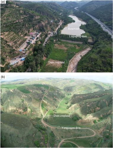
On the Loess Plateau, sediment has been trapped in the gullies with the cascade check dams installed, creating arable land of 927.57 km2 by the end of 2019 (Chen et al., 2020). Figure 4 shows the typical land reclamation due to check dam construction in the gulli. Table 3 summarizes the contributions of check dams to land reclamation on the Loess Plateau. In terms of quantity, 41,008 check dams have been completely filled by sediment, accounting for 69.77% of the 58,776 check dams on the plateau. In particular, the number of check dams completely filled with sediment built before 1986, between 1986 and 2003, and after 2003 were 28,198; 8624 and 4186, respectively. These numbers represent 87.97%, 62.15% and 32.59% of the check dams constructed during each corresponding period (Chen et al., 2020).
| Period | Before 1986 | 1986–2003 | After 2003 | Total |
|---|---|---|---|---|
| Total storage capacity (108 m3) | 52.90 | 23.81 | 33.62 | 110.33 |
| Design sediment storage capacity (108 m3) | 41.31 | 15.35 | 20.84 | 77.50 |
| Volume of trapped sediment (108 m3) | 38.39 | 10.35 | 6.30 | 55.04 |
| Percentage of sediment trapping (%) | 72.57 | 43.47 | 18.74 | 49.89 |
The land created by check dams is highly productive for agriculture, as opposed to terrace and slope land, owing to its leveled ground and high-water content (Fu et al., 2017; Wang et al., 2011a). Irrigation is ensured even during drought seasons because these lands enable the collection of precipitation in the gully. It is estimated that a dam land of 1 mu (1 mu = 667 m2) can replace the original slope land of 6–10 mu on the gullies, which will, in turn, be transformed into a forest and a grassland. With the implementation of the “Grain for Green” program in 1999, a total of 41.17 million mu slope land had been converted to forest and grassland. For example, in the Wangmaogou watershed in Yulin, Shaanxi Province, the forest area increased from 3% to 45% and the grassland area increased from 3% to 7% because of the new land created by the check dams (Chen et al., 2020).
2.2 Environmental impact
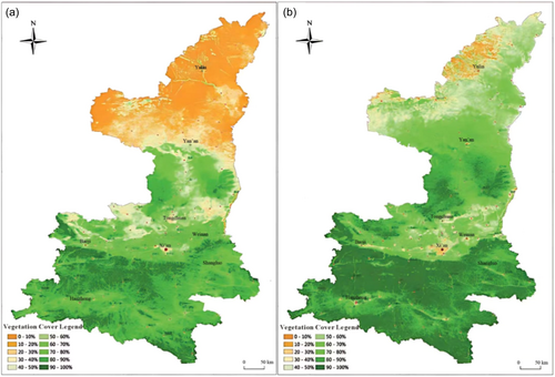
The check dam system has transformed gullies into terraces, reducing the kinetic energy of channel runoff and altering the erosion pattern of the watershed. This means that check dams not only retain sediment but also reduce the gravitational erosion potential of gullies by raising the erosion level. As a result, the entire watershed on the Loess Plateau has become greener. For example, the annual maximum normalized difference vegetation index and the annual average fractional vegetation cover in Shaanxi Province increased by 32.2% and 20.8%, respectively, from 2001 to 2017 (Li & Wang, 2020; Yin et al., 2021a). Green China (2020) reported that the green area expanded northwards by more than 400 km from 2000 to 2018 in Shaanxi Province (Figure 5). The forest coverage and living wood growing stock had reached 41% and 424 million cubic meters by the end of 2020 (Zhang et al., 2024). In addition, 300 administrative villages in Shaanxi Province were recognized as “National Forest Villages” by the National Forestry and Grassland Administration. By implementing the “Three-North Shelter Forest” program since 1978 (Zhai et al., 2023), the “Grain for Green” Program since 1999 (Huang et al., 2023) and other soil and water management projects, the advancement of the Mu Us Sandy Land has been halted (Gao et al., 2022).
With increasing improvements in the ecological environment, the Loess Plateau has become home to wild animals. The Ziwuling forest area in Yan'an City is a key distribution area of the North China leopard, which is a national first-class protected wild animal. The crested ibis, which has very strict requirements for its habitat environment, was discovered near Dujiabian Village of Yan'an City.
2.3 Sedimentation retention
The impact of check dams on sediment retention and erosion reduction is a significant factor contributing to the recent decrease in sediment entering the Yellow River. The measured annual average sediment discharge from 2000 to 2012 at the Tongguan Hydrological Station on the Yellow River was 276 million tons, which was 1.316 billion tons less than that from 1919 to 1959. Preliminary studies indicated that check dams installed above the Tongguan Hydrological Station trapped sediment and reduced erosion by an annual average of 450 million tons, accounting for a 34% reduction in the sediment discharge in the Yellow River from 2000 to 2012 (Li & Liu, 2018). Ran et al. (2008) concluded that the sediment trapped by check dams accounted for 64.7% of the total sediment reduction due to all soil and water conservation measures in the Hekou–Longmen reach from 1970 to 1996. Wang et al. (2016) demonstrated that check dams and reservoirs accounted for 21% and 12% of the total sediment reduction in the Hekou–Tongguan reach (i.e., the middle reach of the Yellow River) between 1951 and 1999 and 2000–2010, respectively. Liu et al. (2018) compared the sediment trapped by check dams above the Tongguan section in the Hekou–Longmen reach and the upper reach of the Beiluo River from 1950 to 2014, as shown in Figure 6. The sediment retention of check dams peaked during the period from 1970 to 1989 and declined thereafter, which might be partly attributed to the saturation of the sediment storage capacity of some check dams and the remarkable sediment reduction by vegetation restoration with the “Grain for Green” Program since 1999 (Gao et al., 2024; Wang et al., 2016; Wang et al., 2017a; Zhang & She, 2021). Approximately 66%–80% of the total trapped sediments above the Tongguan section were retained in the Hekouzhen–Longmen reach and the upper reach of the Beiluo River, where the number of large, medium and small check dams accounted for 70%, 80%, and 91%, respectively, of all check dams constructed above the Tongguan section (Liu et al., 2018).
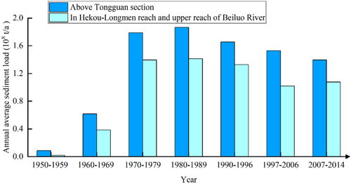
Table 4 compares the effectiveness of check dams in retaining sediments in two small watersheds during a typical extreme rainfall event: one is the Jiuyuangou watershed, which was harnessed by check dams, whereas the other is the Peijiamao watershed, which was basically untamed (Zhao et al., 2019). There are 241 check dams in the Jiuyuangou watershed, including 28 large, 42 medium, and 171 small dams. Their total storage capacity is 42.37 million m3, and their sediment retention capacity is 34.15 million m3, corresponding to a dam land development of 4.33 square kilometers. In contrast, the Peijiamao watershed is underdeveloped in terms of check dam construction. On July 26, 2017, an extreme rainstorm hit the northern Shaanxi Province, creating a catastrophic flood with a return period of roughly 100 years in this region. With roughly the same rainfall amount in these two watersheds, the maximum sediment concentration in Jiuyuangou was 170 kg/m3, compared to 382 kg/m3 in Peijiamao. The sediment transport modulus in Jiuyuangou was 75.8% lower than that in Peijiamao without soil or water management.
| Name of the watershed | Catchment area (km2) | Rainfall duration (h) | Rainfall (mm) | Runoff depth (mm) | Runoff coefficient | Flood peak discharge (m3/s) | Maximum sediment concentration (kg/m3) | Sediment transport modulus (t/km2) |
|---|---|---|---|---|---|---|---|---|
| Jiuyuangou | 70.11 | 51.3 | 156.1 | 18.39 | 0.12 | 36.14 | 170 | 1914 |
| Peijiamao | 39.30 | 36.5 | 156.7 | 45.50 | 0.29 | 126.10 | 382 | 7595 |
3 ADVANCES IN FLOOD MITIGATION TECHNIQUES
3.1 Flood incidents on check dams
As small-scale earth structures are mainly built by local peasants, check dams normally have low construction standards, and incidents caused by floods have been frequently reported (e.g., Guo et al., 2021; Liu et al., 2020; Yang et al., 2020).
3.1.1 Dam failure due to heavy rainfall
The return period of check dams, such as large check dams specified by the design standard, is generally 30–50 years (CMWR Ministry of Water Resources of the People's Republic of China, 2020b). Moreover, many check dams do not have spillways. Overtopping is the most probable hazard triggered by extreme rainfall and the consequent super-standard floods. Table 5 summarizes typical check dam breach events on the Loess Plateau (updated by Chen et al., 2020).
3.1.2 Dam failure due to inadequate flood release facilities
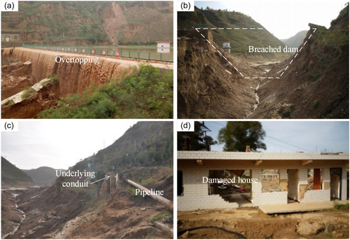
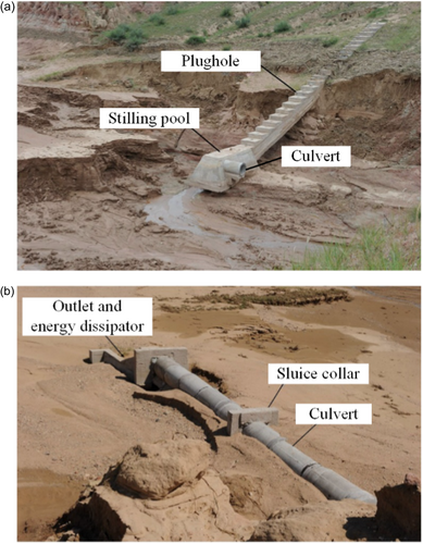
Check dams, especially those constructed by self-organized local peasants before the 1980s, do not have spillways, which makes the flood control system very fragile against extreme weather conditions. Figure 7 shows a recent case of a check dam breach. The Qingshuigou Reservoir, completed in 2010, which supplies water to Zizhou County in Shaanxi Province, had a total storage and flood detention capacities of 370,000 and 280,000 m3, respectively. When heavy rainfall with a maximum 1-h rainfall of 52 mm happened on July 26, 2017, the Qingshuigou Dam overtopped and breached a height of 25 m (Zhang et al., 2019; Zhang, 2017). The lack of a spillway for this dam, which was used for normal water storage and supplied water to the nearby county, is the main reason for the dam's failure.
3.1.3 Dam failure due to breaking of the underlying conduit
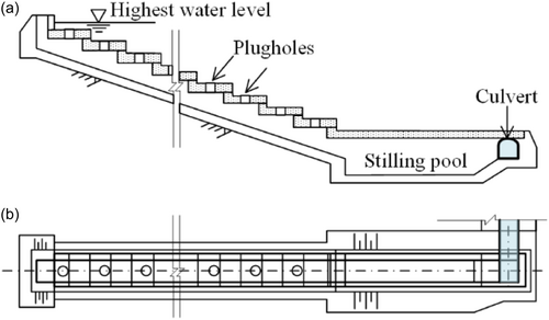
Figure 8 shows a typical water release conduit, which is normally placed under the body of the dam. Since it is designed to work in open-channel conditions, hazards frequently occur owing to the failure to allow such working conditions by accidental inflow into this system, resulting in piping and dam breaches (Figure 9).
3.2 Flood risk assessment and mitigation in check dam watersheds
3.2.1 Quantifying flood risks for a clustered check dam system
The number of check dams on the Loess Plateau is so large that it is impractical to reinforce each dam to meet the requirements of the safety control standards (Guo et al., 2021). For a watershed that involves a group of check dams without adequate countermeasures against failure, an important approach for mitigating possible hazards is to develop a dam safety administration system that can identify flood-affected regions and issue an early warning. Risk evaluation of flood hazards due to overtopping by heavy rainfall, along with computer software, can contribute to this system.
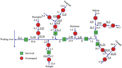
Figure 10 shows the Wangmaogou check dam system, which exhibits complex series and parallel connections of 22 dams. When conducting a rainfall flood routing for each dam, it is necessary to consider the inflow released from the upstream tributary dams due to dam break or spillway discharge. More recently, this complex problem was successfully solved by proposing a refined analysis method to determine the critical rainfall threshold of a dam system (Chen et al., 2021; Zhang & Chen, 2019). It is observed that a check dam system has characteristics similar to human genealogy, that is, there is a backbone dam that controls the runoff of the entire watershed at the downstream terminal of the dam system, referred to as the “ancestor dam,” such as Wangmaogou 1# dam. From this dam, we can trace back upstream and find the “next generation” of dams. In this way, by tracing generation after generation towards upstream, the last batch of “boundary dams” without “descendants” is reached. Following this philosophy, a computer program was developed to identify whether check dams were overtopped or breached by floods under a given amount of rainfall. This is a refined algorithm that fully considers the possible formation of inflows owing to dam breakage and discharge in the upstream dam. We call this the “family tree method” (Chen et al., 2021).
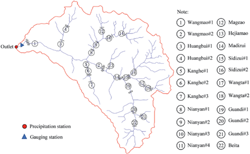
Figure 11 shows the risk analysis results of 22 dams under a maximum 12-h rainfall of 179.6 mm (equivalent to a 200-year return period). The red-filled circles indicate the breached dams, and green-filled boxes indicate the surviving dams. It should be noted that the numbers represent the amount of inflow into the dam in units of 1000 m3. Those with and without underscores represent contributions from upstream dams and natural runoff in the watershed, respectively. For example, Dam No. 8 is marked with inflow values of 6.7 and 41.1, which means that the amount of natural runoff and released water from the upstream dams are 6700 and 41,100 m3, respectively.
3.2.2 Easy and quick dam breach flood evaluations and early warning
Over the past decade, the authors have been working on updating the existing dam breach analysis methods (Chen et al., 2015, 2019a, 2019b). The main improvements include (i) a hyperbolic soil erosion model, (ii) an empirical approach to model the lateral enlargement of the breach opening and (iii) a numerical algorithm that adopts velocity increments to allow a straightforward calculation of the breach flood hydrograph. Figure 12 shows the general framework of the updated theoretical methods and numerical algorithms. A computer program, DB-IWHR, has been developed to implement the algorithm, which is a spreadsheet supported by VBA programming. It is free to access and can be downloaded from the website geoeng.iwhr.com/geoeng/download.htm.
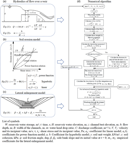
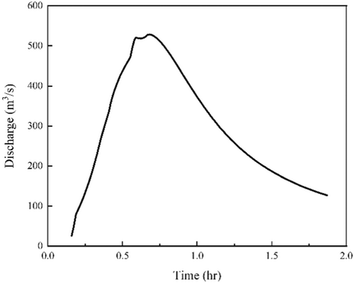
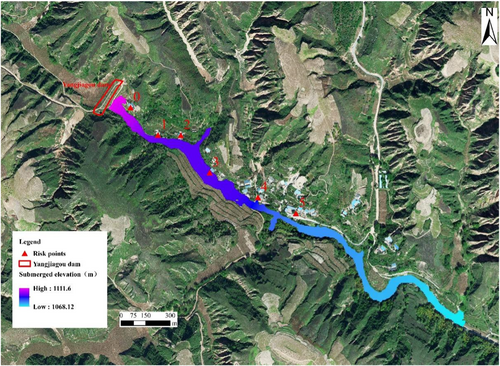
Figure 13 shows an example of the breach risk analysis results for the Yangjiagou check dam located in Yulin City, Shaanxi Province. It controls a drainage area of 1.50 km2 and has a total storage capacity of 515,000 m3. Currently, the sedimentation has occupied 225,000 m3 of its storage capacity. The dam is 25.0 m high with a crest length of 110.0 m. There are six residential areas downstream, labeled 0 to 5. Figure 14 shows the results of the dam-break flood analysis. It can be seen that the peak discharge of 528.52 m3/s was reached after 0.63 h following the breach of Yangjiagou check dam. Among the six risk points, the six houses of the No. 3 risk point were located at an elevation of 1090.54 m, lower than the corresponding flood elevation of 1094.62 m. The other risk points were located above the calculated flood inundation elevation. The estimated outcomes can serve as a useful reference for local administrations in planning risk assessments and disposal measures.
3.3 Novel water-release facilities
3.3.1 Geobag stepped spillway
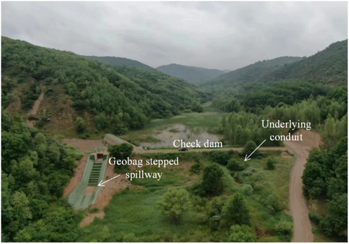
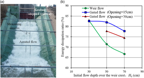
Developing a new, reliable, and economical type of spillway is important for mitigating flood risks in check dams. The authors developed a new type of spillway to address this issue (Yu et al., 2019, 2023). Figure 15 shows the geobag stepped spillway built at the Sanlian check dam in Ya'an, Shaanxi Province. The dam has a height of 6 m and the spillway is 3.8 m wide with a slope of 2 on 1 (horizontal on vertical). Ten full-scale overflow tests were performed with gated and uncontrolled weir flows at different water heads on the weir. The energy dissipation ratio was greater than 67% under all circumstances (Figure 16). After the overflow tests, the structure of the geobag stepped spillway was stable with negligible deformation, indicating that this novel spillway was successful and can be used in actual check dam projects. The geobag stepped spillway has been adopted in three check dams on the Loess Plateau as a permanent flood-release facility.
| Time | Location | Watershed | Rainfall | Breached or damaged check dams |
|---|---|---|---|---|
| July 25–26, 2017 | Yulin, Shaanxi | Qingshuigou, Majiagou and Shejiagou | Maximum 1-h rainfall of 52 mm and maximum 12-h rainfall of 211 mm | 13 check dams were destroyed in Majiagou. The drainage channels of two check dams were damaged in Qingshuigou. Gullies on the dam and damage to the spillway were observed in one check dam in Shejiagou (Wang et al., 2017b). |
| August 16–18, 2016 | Ordos, Inner Mongolia | Xiliugou and Hantaichuan | Maximum 1-h rainfall of over 50 mm and maximum 24-h rainfall of 248.8 mm | 19 check dams, including 12 large, five medium and two small dams breached, all of which did not have spillways. The cascade dams of Youfangqu Nos. 1, 2 and 3 and Dawulanstaigou dam collapsed (Wang et al., 2019). |
| July 2013 | Yan'an, Shaanxi | Yanhe River | Five rainfall processes with the frequency exceeding a 100-year return period, with the maximum cumulative point rainfall of 792.9 mm | 516 check dams were damaged, most of which had been fully filled with sediment and did not have spillways (Wei et al., 2015). |
| July 15, 2012 | Yulin, Shaanxi; | Jiuyuangou | Maximum 1-h rainfall of 75.7 mm | 24 check dams (45 in total) were damaged to different extents (Gao et al., 2017). |
| September 19, 2010 | Lvliang, Shanxi | Dianpinggou, Shizhang and Yangpo | Maximum 2-h rainfall of 185 mm and some areas experiencing 24-h rainfall exceeding a 200-year return period | The total water storage of 71 large and medium check dams reached 14.3 million m3. The culvert collapse and gullies in dams were observed in four check dams in Fangshan County. The Xize dam in Lishi District was breached due to overtopping (Wang et al., 2011b). |
| July 8, 2000 | Lvliang, Shanxi | Wangjiagou | Maximum 30-min rainfall of 32.1 mm with a frequency less than one in 50 y | Four check dams were perforated, and the foundations of one dam spillway and one dam culvert outlet were locally scoured and suspended, with the sediment of 6973 m3 scoured away (Nie et al., 2000). |
| August 1994 | Shaanxi, Shanxi, Inner Mongolia, Gansu and Ningxia Hui | Middle reaches of the Yellow River | 4–7 regional heavy rainstorms with rainfall of 50%–60% more than that during the same period in the previous years | 7542 check dams (8% of the total amount in the middle reaches of the Yellow River) suffered, to different extents, water-induced damage with a loss of 33 km2 dam cropland and a total investment of 374 million RMB for repairment (Wang & Wang, 1995). |
| July 22, 1989 | Lvliang, Shanxi | Yujiagou and Liuyegou | Maximum 1-h rainfall of 90 mm and maximum 6-h rainfall of 178.8 mm with a 500-year return period | 91 dams (205 in total) were destroyed, and the sediment of 743,600 m3 was scoured away in Xing County. The dam cropland with an area of 2505 mu was destroyed, and crops with an area of 1260 mu were flooded (Ma et al., 1990). |
3.3.2 Pressurized conduit
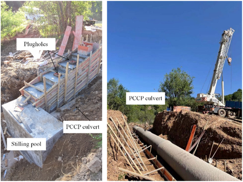
Recently, prestressed concrete cylinder pipes (PCCP) have been widely used in civic water supply and drainage projects and large-scale water conveyance projects (e.g., Cheng et al., 2020; Hu, 2009). They can withstand high internal water pressures, thus mitigating the risk of a dam breach. Figure 17 shows an example that adopts PCCP for releasing water from the check dams in Yan'an, Shaanxi Province.
4 PERSPECTIVES
4.1 Actions on further developments
In the early 1950s, Ning Qian, a renowned sediment expert from China, observed that most of the sediment deposited in the main channel of the Yellow River consisted of coarse particles larger than 0.05 mm (Qian et al., 1978). Table 6 summarizes the landforms, hydrology, and land use in the high and coarse sediment yield zone located in the middle reaches of the Yellow River (Li et al., 2021; Yin et al., 2021b).
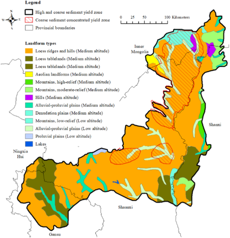 |
Landform: Main landforms are loess tablelands, ridges and hills with dense and deep gullies and steep slopes. The topsoil mainly consists of the erodible loess, which is a loose aeolian deposit of yellowish silt-dominated dust. |
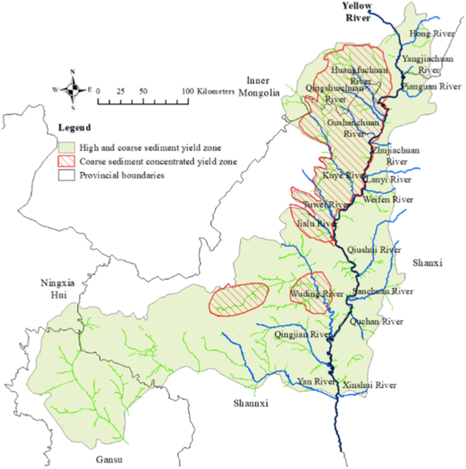 |
Hydrology: Located in the arid and semi-arid region, the multi-annual average precipitation in the zone is around 450 mm, which decreases from the southeast to the northwest. Greater than 60% of the whole-year precipitation occurs usually in the form of heavy rainstorms in the summer (i.e., from July to September). The Yellow River and over ten tributaries go through. The topsoil (i.e., loess) is eroded and transported into the Yellow River. |
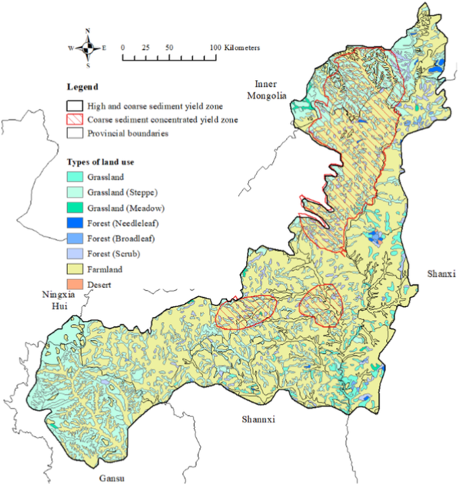 |
Land use: Main types of land use are grassland, forest, and farmland. The annual average vegetation cover area and fractional vegetation cover (FVC) increased by 10,000 square kilometers and 18.5%, respectively, which partly results in the remarkable reduction in the soil erosion from 1999 to 2020. |
This high and coarse sediment yield zone covers an area of 78,600 square kilometers, where the sediment transport modulus and coarse sediment transport modulus exceed 5000 and 1300 tons per square kilometers per year, respectively. The region's landforms, soil characteristics, river systems, and climatic conditions result in the most severe water-driven erosion within the Yellow River's middle reaches.
Specifically, the concentrated coarse sediment yield zone spans an area of 18,800 square kilometers, with a multi-annual average sediment transport of 255 million tons per year. This zone primarily encompasses the watersheds of the Huangfuchuan, Qingshuichuan, Gushanchuan, Shimachuan, Kuye, Tuwei, Jialu, Wulong, Wuding, Qingjian, and Yan Rivers. These tributaries form eleven sub-reaches between Hekou and Longmen on the right bank of the Yellow River.
The coarse sediment concentrated yield zone is the main source of the soil erosion on the Loess Plateau and, consequently, the continuous sediment siltation in the main channel in the lower reaches of the Yellow River (Li et al., 2023; Liu et al., 2023). Therefore, during China's “14th 5-Year Plan,” the construction of check dams in the Yellow River will focus on this region, and more than 3000 check dams will be planned. At present, the first phase of the sediment-retaining project is in full swing, including 2559 small and medium sediment-retaining dams (Chen, 2022; Hui et al., 2024).
4.2 Promotion of the green corridor on the Loess Plateau
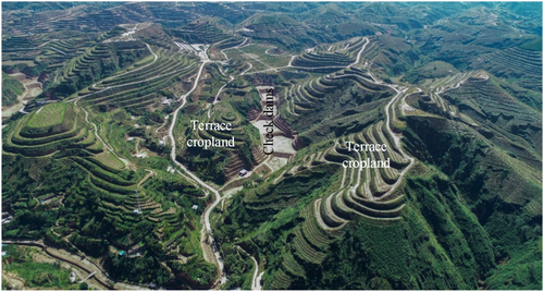
Combining check dam construction with terrain reclamation has become a new endeavor to promote soil and water conservation on the Loess Plateau (Chen, 2022). As shown in Figure 18, for example, by pumping water from the Liujiaping reservoir using solar energy, the Zhaojiagua loess terrain in Yulin, Shaanxi Province, has been transformed into 18,000 mu forests and orchards. This pioneering study has attracted extensive attention.
4.3 Upgrading the flood release facilities
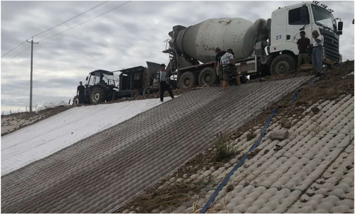
To improve the construction quality of the stepped geobag spillway in check dams as described in Section 3.3.1, the approach of the pumped concrete mattress could provide a reliable and economical cast-in-place alternative to the geobags filled with the compacted loess (Yu et al., 2023). Figure 19 shows an example of the pumped concrete mattress construction for channel lining.
5 CONCLUSIONS
- 1.
Check dams have retained 5.5 billion m3 of sediment that would otherwise have entered the Yellow River. Owing to check dams, a 34% reduction in sediment discharge annually in the Yellow River has been achieved from 2000 to 2012.
- 2.
The highly arable land created by the check dams provides basic living standards for local peasants and pushes forward the endeavor of rural revitalization currently being exercised by the Chinese government.
- 3.
Check dams reduce the gravitational erosion and minimize agricultural land on the slope, resulting in forests on the terrain and a greener Loess Plateau.
- 1.
A novel geobag stepped spillway constructed using the composite geotextile and the local loess material was proposed and developed by the authors. It has a high tensile strength against cracking and a high-efficiency energy dissipation, permitting the safe flow of flood water over the check dam. Its low cost renders it promising for widespread practical applications.
- 2.
Applications of the PCCP have opened up new approaches for safe water release through the conduits embedded in the dam body owing to their capability of sustaining a high internal water pressure.
- 3.
A dam-safety monitoring system incorporating an accurate risk assessment model along with a dam breach early-warning model will considerably enhance the security of the local inhabitants downstream of the check dams on China's Loess Plateau.
ACKNOWLEDGMENTS
This research was funded by the National Natural Science Foundation of China (Grant No. 42330719, U2443228), the Power Construction Corporation of China (Grant No. DJ-ZDXM-2021-51), and the special fund of China Institute of Water Resources and Hydropower Research for the transformation of scientific and technological achievements (Grant No. GE121003A0042022).
ETHICS STATEMENT
None declared.
Open Research
DATA AVAILABILITY STATEMENT
The data that support the findings of this study are available from the corresponding author upon reasonable request.


