

Journal list menu

 Issue
IssueHydrological Processes: Volume 34, Issue 25
4759-518415 December 2020
Export Citations
Download PDFs
ISSUE INFORMATION
USING WATER AGE TO EXPLORE HYDROLOGICAL PROCESSES IN CONTRASTING ENVIRONMENTS
Snowpack disrupts relationship between young water fraction and isotope amplitude ratio; approximately one fifth of mountain streamflow less than one year old
- Pages: 4762-4775
- First Published: 20 September 2020
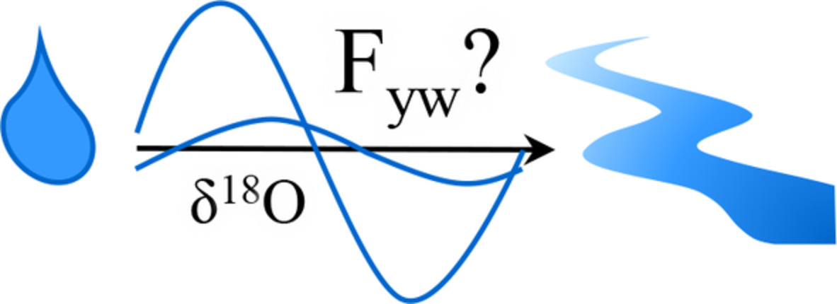
Snowpack disrupts seasonal cycles of isotopic variability, preventing accurate estimation of Fyw in catchments with overwinter snowpack Monte-Carlo simulations produce a range of possible Fyw for a given measured Ar/Ap, and together with an independent estimate, show that ~1/5 of streamflow in the study catchment is less than 1 year old.
Modelling non-stationary water ages in a tropical rainforest: A preliminary spatially distributed assessment
- Pages: 4776-4793
- First Published: 01 October 2020
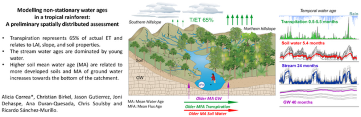
- Transpiration represents 65% of actual ET and relates to LAI, slope, and soil properties.
- The stream water ages are dominated by young water.
- Higher soil mean water age (MA) are related to more developed soil sand MA of ground water increases towards the bottom of the catchment.
Seasonal snow cover decreases young water fractions in high Alpine catchments
- Pages: 4794-4813
- First Published: 11 October 2020
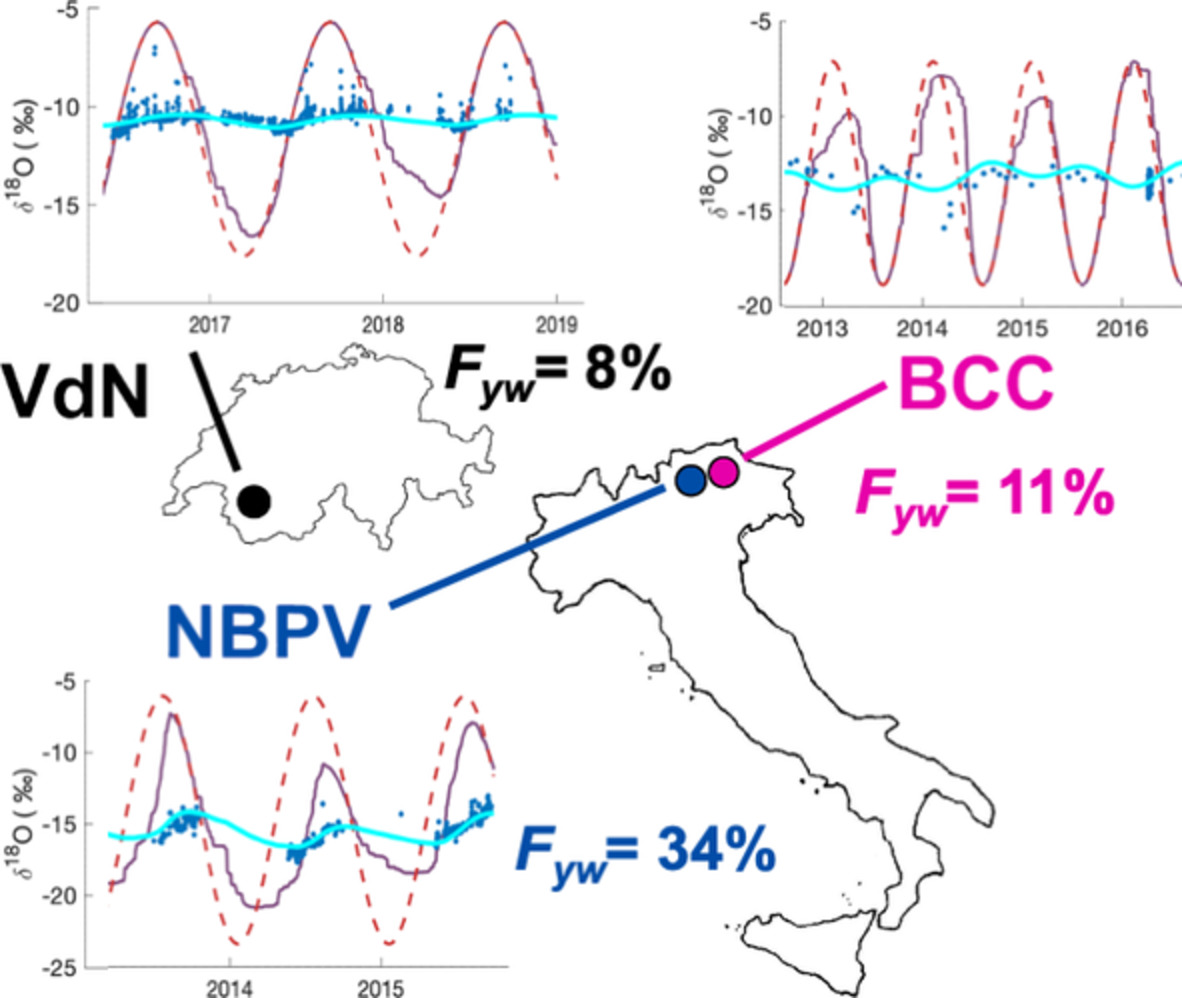
This paper proposes a framework to quantify the young water fraction of streamflow (FYW) in snow-dominated catchments based on stable water isotopes and a simple snow accumulation model. Based on three case studies from the Alps, the challenges and pitfalls of FYW estimation in presence of seasonal snow cover are discussed, with ensuing recommendations for best practices. The results confirm previous findings that seasonal snow cover leads to low FYW.
WOMEN ADVANCING RESEARCH IN HYDROLOGICAL PROCESSES
River management response to multi-decade changes in timing of reservoir inflows, Columbia River Basin, USA
- Pages: 4814-4830
- First Published: 17 September 2020
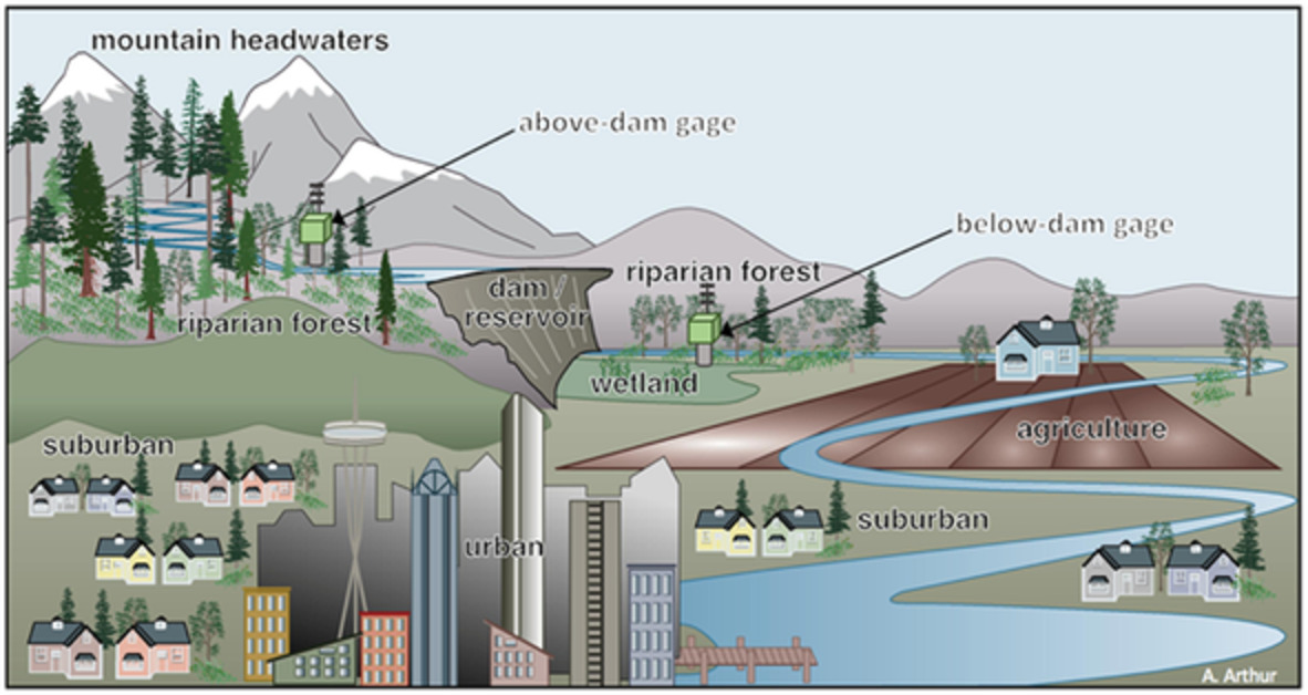
Analysis of publicly available data on inflows and outflows of 25 major reservoirs from 1950 to 2012 in the 668,000 km2 Columbia River basin, USA, revealed multi-decade reductions in dry season reservoir inflows, and smaller reductions in outflows. Managers have increased hedging in the spring and early summer, but this has not completely offset multi-decade decreases in inflows. Vulnerability to spring floods and dry season shortfalls is higher during years with low inflows, indicating a potential long-term increase in vulnerability.
Land-use dominates climate controls on nitrogen and phosphorus export from managed and natural Nordic headwater catchments
- Pages: 4831-4850
- First Published: 11 October 2020
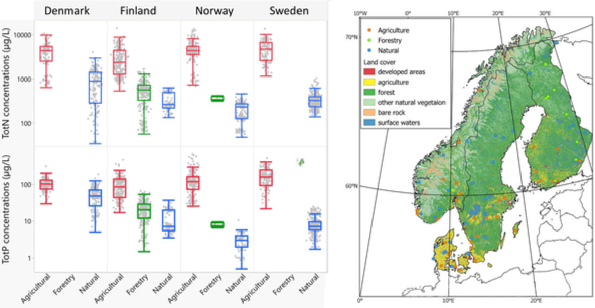
Range of totN and totP concentrations (annual medians in (μg−1)) for 69 Nordic catchments grouped by country and dominating land use (agricultural, forestry-impacted and natural), for the period 2000–2018.
A TRIBUTE TO EDWARD P. GLENN (1947–2017): A LEGACY OF SCIENTIFIC ENVIRONMENTAL ASSESSMENT AND APPLICATIONS IN HYDROLOGICAL PROCESSES
Ecohydrological responses to surface flow across borders: Two decades of changes in vegetation greenness and water use in the riparian corridor of the Colorado River delta
- Pages: 4851-4883
- First Published: 19 September 2020
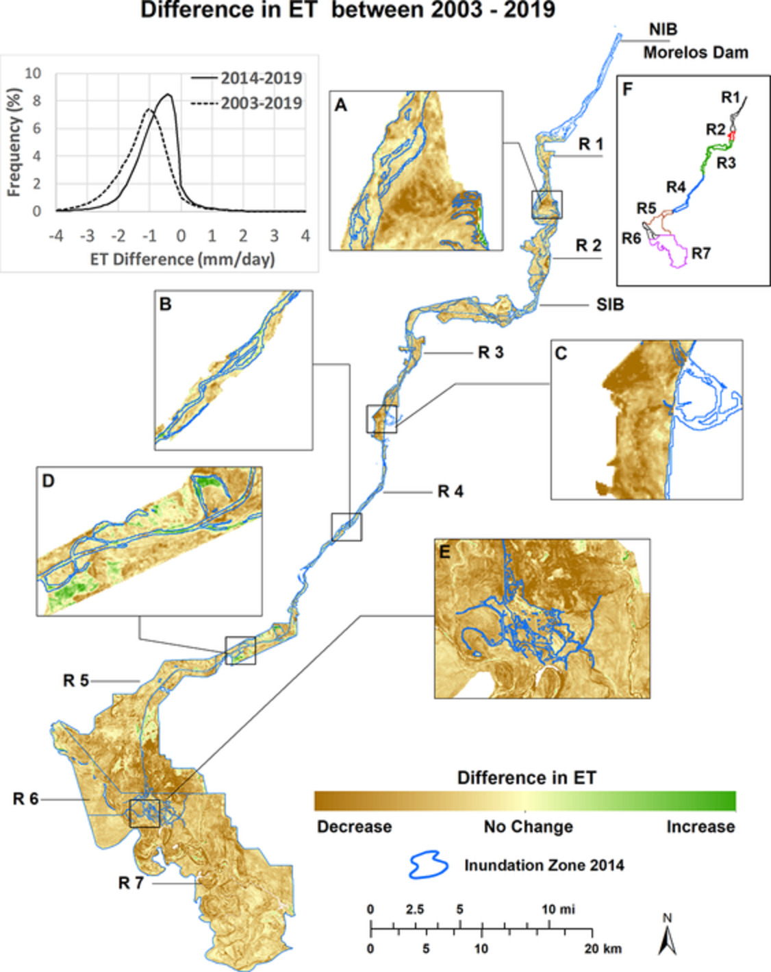
Riparian reaches in the delta of the Colorado River have undergone reductions in green vegetation from human-induced activities that have caused water stress to plants. The reduction is due to the diversion of surface water at the international border, groundwater losses, land clearing, fire and minimally from precipitation patterns. A key finding is that active restoration of native plants and timing of water deliveries has been beneficial in slowing the decrease over time in the two metrics in our study, vegetation greenness and plant water use, to nearly half. However, the success of the Minute 319 environmental pulse flow in 2014 was short-lived (1–2 years) and then declines resumed.
We measured declines over the last 20 years. Greenness as measured by vegetation indices (VIs) declined 34% (EVILandsat) and 30% (EVIMODIS), while ET losses were 1.58 mm/day (38%; ETLandsat-EVI) and 1.13 mm/day (27%;ETMODIS-EVI). A key finding is that in a few reaches, greenness declined as much as 44% with a corresponding ET loss of 624 mm/year or 2.13 mm/day (51%). We found that the full-year PAM ETLandsat-EVI dropped from 1,130 mm/year in 2000 to 654 mm/year in 2019, a difference of 476 mm/year over 20 years.
However, since the environmental pulse flow in 2014, declines in vegetation greenness over these past 5 years were less. Over the last 5 years, the VI signal decline was 20% (EVILandsat) and 13% (EVIMODIS), while ET losses were 0.77 mm/day (23%; ETLandsat-EVI) and 0.13 mm/day (4%; ETMODIS-EVI), a 5-year drop of 209 mm/year. A key finding is that the pulse flow water in 2014 resulted in a 5-year increase of 14–17% and ET of 0.81–1.00 mm/day, a difference of 267 mm/year, compared to the 20-year data.
Climate sensitivity of water use by riparian woodlands at landscape scales
- Pages: 4884-4903
- First Published: 15 October 2020

ET of groundwater-dependent riparian woodland ecosystems (GDEs): High spatial variablility of ET and differing relationships between vegetation structure and ET within overstory woodlands. Climate sensitivity of ET differs by streamflow permanence, showing promise as a remote indicator of subsurface water availability.
RESEARCH ARTICLES
Field studies on the influence of rainfall intensity, vegetation cover and slope length on soil moisture infiltration on typical watersheds of the Loess Plateau, China
- Pages: 4904-4919
- First Published: 23 August 2020
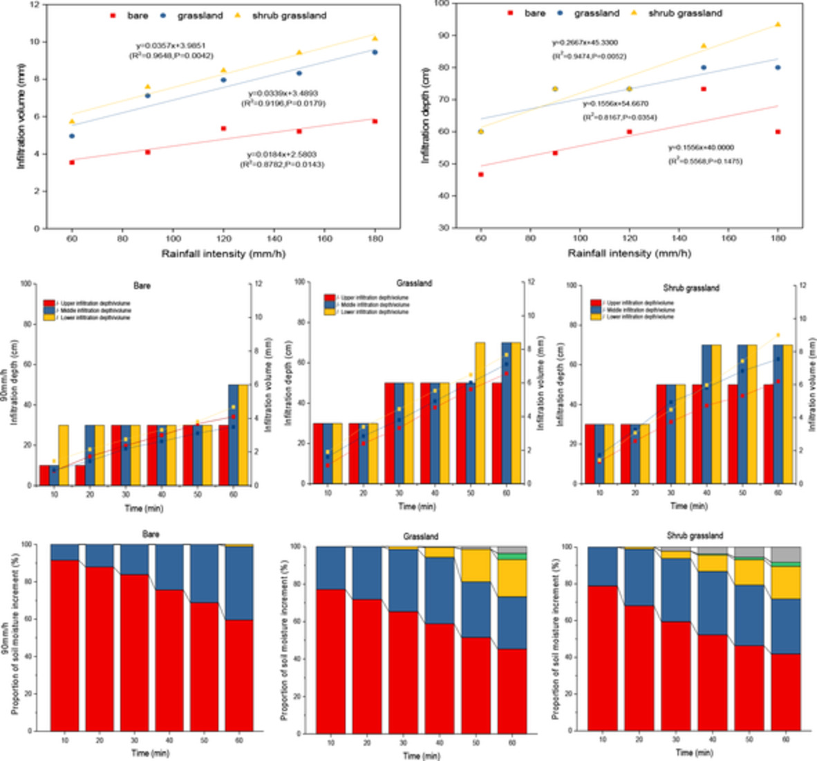
The effects and contribution of vegetation cover rainfall intensity and slope length on vertical and spatial changes of soil water infiltration were quantified. The existence of saturated lateral runoff was found and it was considered that the spatial interleaving of root system also formed the difference of soil infiltration capacity between different soil layers, which provided the possibility of lateral runoff. Rainfall intensity, vegetation canopy interception and slope length confluence provided sufficient water supply for the occurrence of lateral runoff.
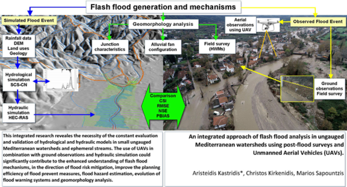
An integrated approach of flash flood analysis in ungauged Mediterranean watersheds using post-flood surveys and unmanned aerial vehicles
- Pages: 4920-4939
- First Published: 18 September 2020
Hydrological resilience to forest fire in the subarctic Canadian shield
- Pages: 4940-4958
- First Published: 20 September 2020
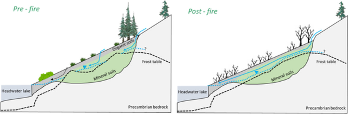
Conceptualization of the influence of fire and a loss of the soil organic layer on frost and water tables present on a subarctic Canadian Shield hillslope. The water table is denoted by the inverted blue triangle and dotted blue line. The frost table is denoted by the black dashed line. The blue arrows illustrate how saturated subsurface flow could be intercepted by a higher frost table associated with conditions before fire
Sampling soil water along the pF curve for δ2H and δ18O analysis
- Pages: 4959-4972
- First Published: 25 September 2020
Few studies have looked into the relevance of soil water held across different sized pores and water adsorbed on various soil materials with respect to their isotopic composition. Here, we present a pressure plate experiment with two soils differing in their physico-chemical properties where we explore the effect of water retention characteristics on the water isotopic composition of soil pore water sampled along the pF curve.
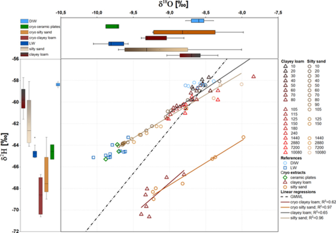
Dual isotope plot for clayey loam (grey to red) and silty sand (brown to beige) extracts over 7 days of extraction at 15 bar in comparison to soils (clayey loam: dark red, silty sand: orange) extracted cryogenically after 7 days in the pressure extractor, crushed ceramic plates (light blue) extracted cryogenically, Lauretana water (LW) used for spiking the soils (dark blue) and distilled water (DIW) used for wetting the ceramic plates (light blue). For reference, plot includes the global meteoric water line (GMWL: δ2H = 8.2·δ18O + 11.3 ‰, as defined by Rozanski, Araguás-Araguás, and Gonfiantini (1993) and soil water regression lines for the pressure plate extracts and the cryogenically extracted soil water.
Changes in groundwater bacterial community during cyclic groundwater-table variations
- Pages: 4973-4984
- First Published: 25 September 2020
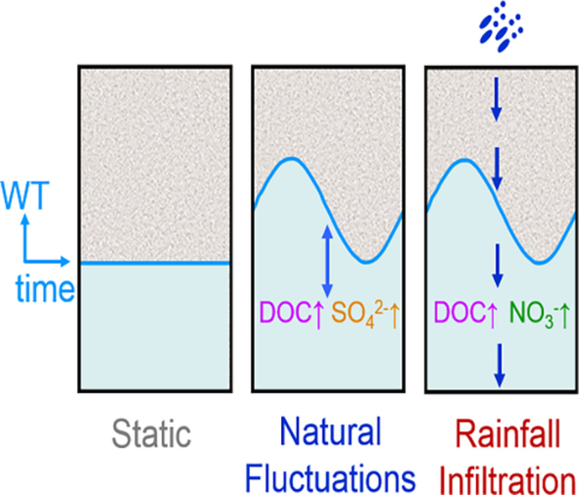
Water-table variations in a fluvial-sand aquifer promote soil organic matter mineralization in the vicinity of the water table. Cyclic natural fluctuations result in the accumulation of SO42− just below the phreatic surface, whereas net downward flow during rainfall infiltration results in elevated NO3−. Evolution of the groundwater bacterial community is constrained by the geochemistry, and thus differs under different hydrological dynamic regimes.
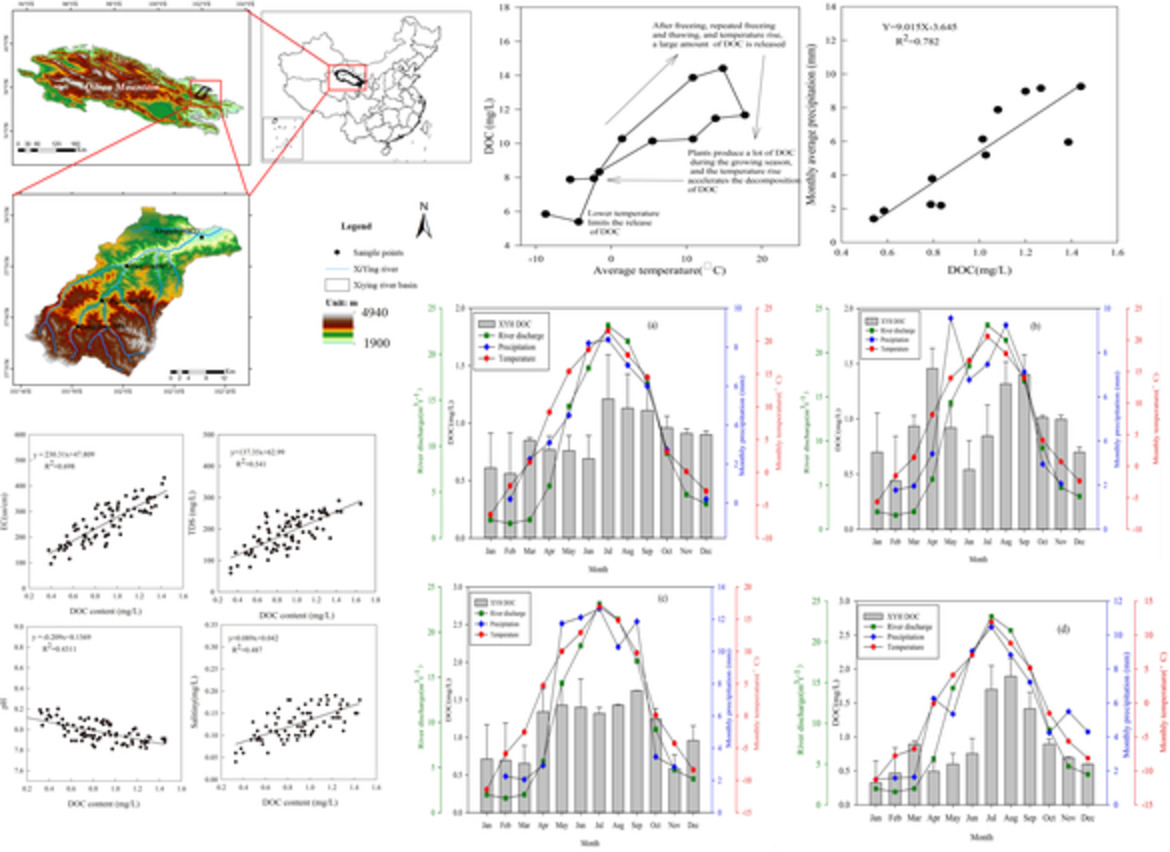
Dissolved organic carbon transport in the Qilian mountainous areas of China
- Pages: 4985-4995
- First Published: 25 September 2020
Evaluation of temporal consistency of snow depth drivers of a Rocky Mountain watershed in southern Alberta
- Pages: 4996-5012
- First Published: 29 September 2020
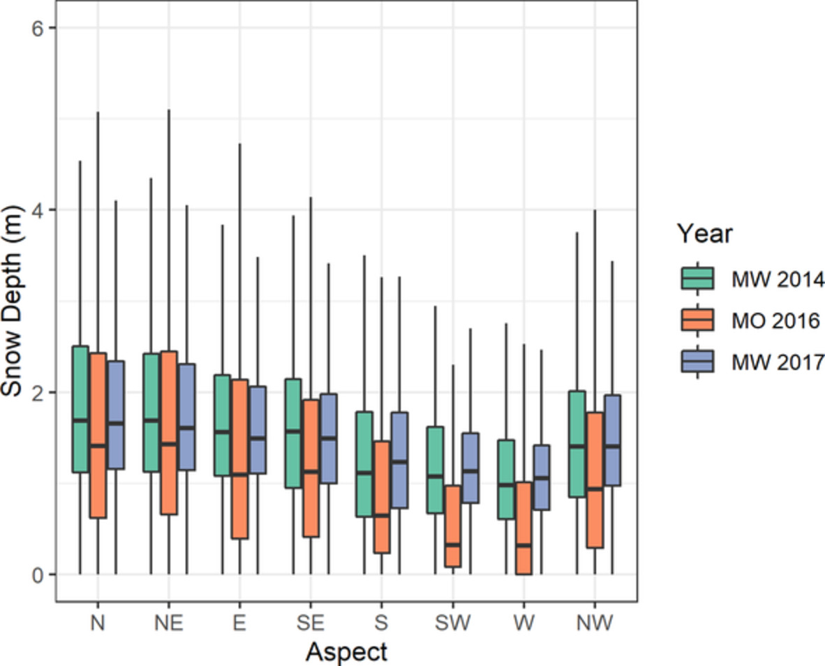
Seasonal snowpack depth estimations during mid-winter and melt onset conditions were derived from airborne Lidar in the southern Canadian Rockies over 3 years. Each dataset was divided into five set of snow depth driver classes: elevation, aspect, topographic position index, canopy cover and slope. Consistent trends were observed among driver classes with peak snow accumulation occurring within the treeline ecotone, north-facing aspects, open canopies, topographic depressions and areas with low slope angle. Lidar snow depth model quality control methods were also explored.
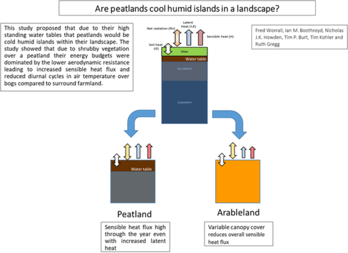
Are peatlands cool humid islands in a landscape?
- Pages: 5013-5025
- First Published: 28 September 2020
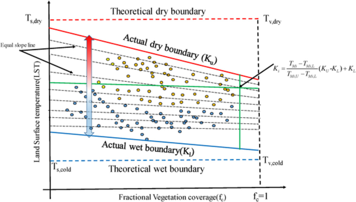
A modified trapezoid framework model for partitioning regional evapotranspiration
- Pages: 5026-5042
- First Published: 30 September 2020
Assessing plot-scale impacts of land use on overland flow generation in Central Panama
- Pages: 5043-5069
- First Published: 30 September 2020
Plot-scale overland flow (OF) generation was compared between forested and pasture-dominated watersheds in central Panama. Measured runoff ratios (overland flow/ rainfall) were higher at the pasture site than at the forest site. Measurements of saturated hydraulic conductivity and bulk density were different between the forest and pasture sites. Discrepancies in observed and HYDRUS-1D-simulated OF help inform differences in OF generation processes between land-use types. At the plot scale, Hortonian overland flow is the main driver for OF at the pasture site during storms with high-rainfall totals. We infer that the combination of a leaf litter layer and the activation of shallow preferential flow paths are likely the main drivers for plot-scale OF generation at the forest site.
On the contribution of groundwater to streamflow in laterite catchments of the Darling Range, south-western Australia
- Pages: 5070-5084
- First Published: 02 October 2020
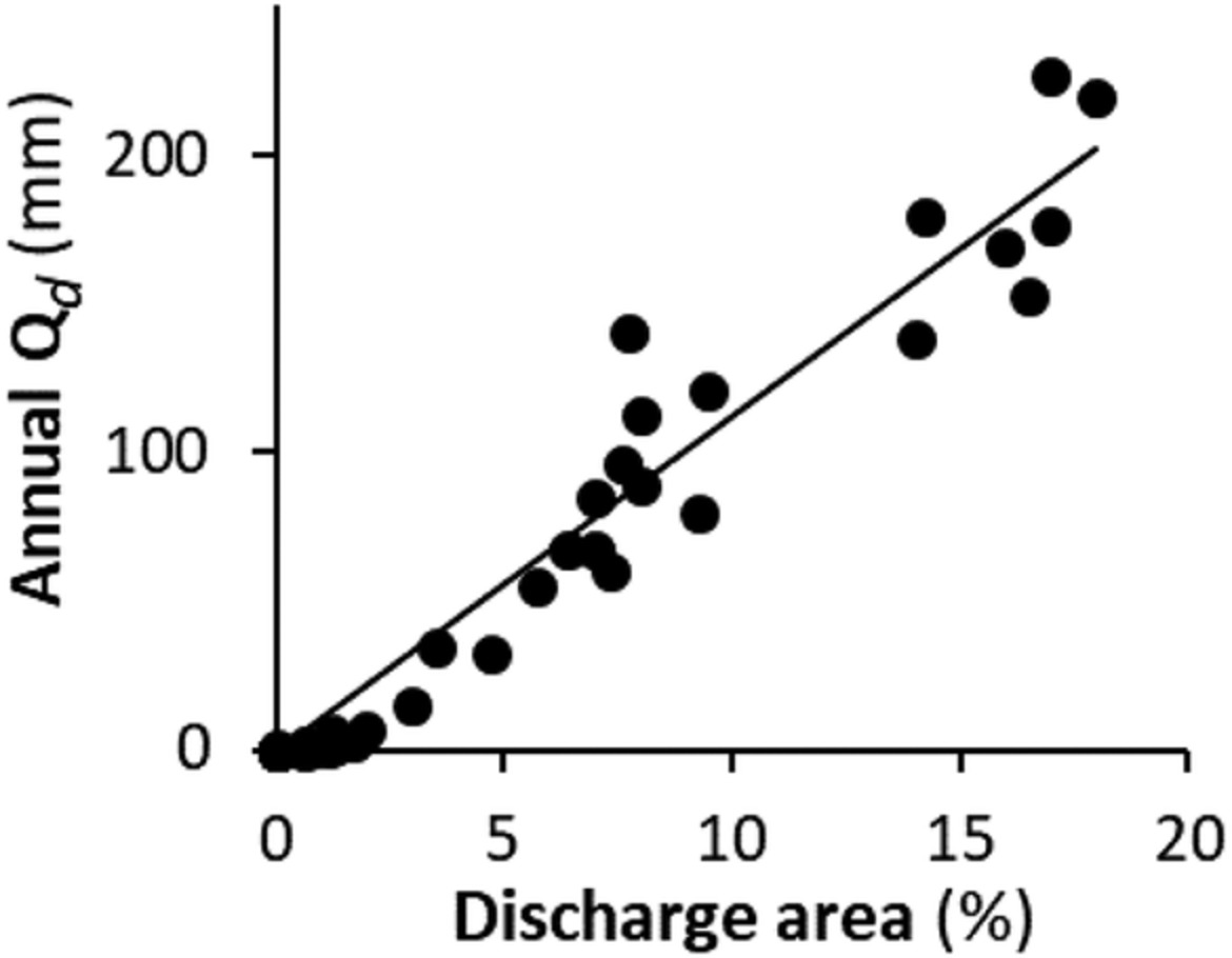
Streamflow in lateritic catchments of south-western Australia was considered to be dominated by shallow throughflow. However, we found groundwater contributions to be far more variable than previously acknowledged, and were dependent on the size of the valley floor discharge area. Streamflow from shallow sources varied primarily with annual rainfall but was “amplified” by the groundwater discharge area.
The role of meteorological forcing and snow model complexity in winter glacier mass balance estimation, Columbia River basin, Canada
- Pages: 5085-5103
- First Published: 04 October 2020
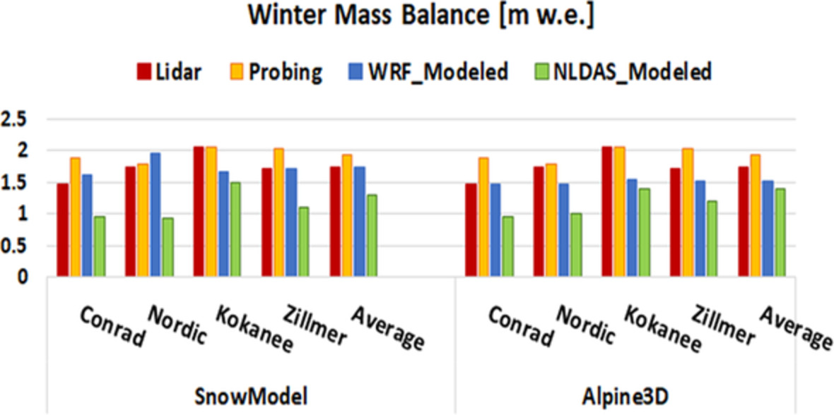
In recent decades, snow models have been developed and improved in light of enhanced understanding of snow process physics and growth in computational power, leading to higher complexity of distributed physics-based snow models. In this study, we evaluate and compare the performance of two snow evolution models with different complexities at simulating winter glacier mass balance using two different datasets. Additionally, we evaluate the performance of two meteorological model datasets (WRF and NLDAS2) that can be used to force snow models as alternatives to weather stations in areas with scarce observations.
Nonlocal transport models for capturing solute transport in one-dimensional sand columns: Model review, applicability, limitations and improvement
- Pages: 5104-5122
- First Published: 08 October 2020
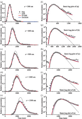
We found that, surprisingly, temporally or spatiotemporally nonlocal transport models (including the multi-rate mass transfer model, the continuous time random walk framework and the time fractional advection-dispersion equation) with a constant dispersivity cannot capture scale-dependent and non-Fickian transport even for conservative tracers moving in saturated, simple sand columns. Scale-dependent dispersion driven by non-uniform distribution of the medium's heterogeneity results in random solute displacements whose distribution is wider than an exponential function. We proposed new models using the space Hausdorff fractal derivative or assuming mobile–mobile mass exchange to capture scale-dependent and non-Fickian transport observed in sand columns. The measured (symbols) versus the best-fit BTCs using the time fractional and space Hausdorff fractal model (red lines) and the two-region time fractional advection-dispersion equation model (blue lines) at five positions (x = 300–1,500 cm) in a 15-m-long sand column with constant parameters. The right plot is the semi-log version of the left plot, to show the BTC tail.
Three hundred years of snowpack variability in southwestern British Columbia reconstructed from tree-rings
- Pages: 5123-5133
- First Published: 08 October 2020
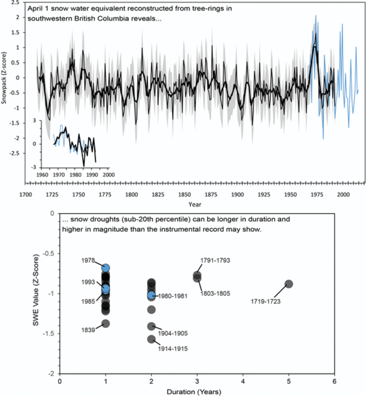
April 1 snow water equivalent reconstructed from tree-rings in southwestern British Columbia reveals snow droughts (sub-20th percentile) can be longer in duration and higher in magnitude than the instrumental record may show.
Identifying non-stationary and long-term river–aquifer interactions as a response to large climatic patterns and anthropogenic pressures using wavelet analysis (Mancha Oriental Aquifer, Spain)
- Pages: 5134-5145
- First Published: 10 October 2020
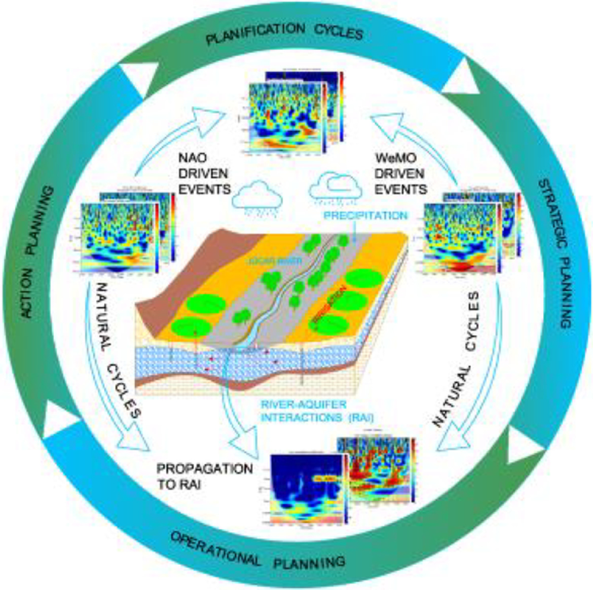
Application of wavelet analysis in strategic water resource planning by identifying long-term variability of Júcar River–Mancha Oriental Aquifer interactions and precipitation with special focus on the correlations between these hydrological variables and the large climatic patterns governing the Iberian Peninsula – the North Atlantic Oscillation and the Western Mediterranean Oscillation.
Design measures to mitigate the impact of shallow groundwater on hydrologic performance of permeable pavements
- Pages: 5146-5166
- First Published: 10 October 2020
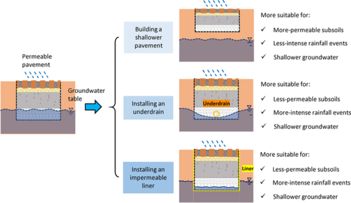
A numerical model was built to simulate an individual permeable pavement (PP) in shallow groundwater. Shallower groundwater led to larger amounts of outflows, and a higher chance of saturating the PP reservoir. The three design measures, including building a shallower PP, installing an underdrain, and installing an impermeable liner, had both benefits and drawbacks in mimicking natural hydrologic cycle and retaining the performance of PP under extreme conditions (e.g., areas of very shallow groundwater tables and/or extreme rainfalls).
SCIENTIFIC BRIEFING
Refining image-velocimetry performances for streamflow monitoring: Seeding metrics to errors minimization
- Pages: 5167-5175
- First Published: 25 September 2020
Bioretention planter performance measured by lag and capture
- Pages: 5176-5184
- First Published: 05 October 2020
Sign up for email alerts
Tools
More from this journal
- Aims and Scope
- Collections/ Special Issues
- Call for Papers: Laboratory and field experiments on soil and rainfall characteristics for studying water erosion processes
- Call for Papers: Drought dynamics and vulnerability
- Pluvial Flooding: Maturing process understanding from data scarcity into data abundance
- Call for Papers: Hydrological processes in lowlands and plains
- Call for Papers: Preferential flow and eco-hydrological processes in the vadose zone
- MG Anderson Awards
- Top Cited Awards
- CHINA Collection
- SEO Guidelines for Authors
HP's Award Winning Articles
We're delighted to announce our 2024 prize winners!
MG Anderson Award
Forest cover lessens hurricane impacts on peak streamflow
Jazlynn Hall, Martha Scholl, James Shanley, Serena Matt, María Uriarte
Top Cited Paper
On strictly enforced mass conservation constraints for modelling the Rainfall-Runoff process
Jonathan M. Frame, Frederik Kratzert, Hoshin V. Gupta, Paul Ullrich, Grey S. Nearing
Top Cited Invited Commentary
Benchmarking hydrological models for an uncertain future
Keith Beven