

Journal list menu

Export Citations
Download PDFs
Table of Contents
Quantifying streambank erosion: A comparison of physical surveys, aerial imagery and UAS LiDAR surveys
- First Published: 14 May 2025
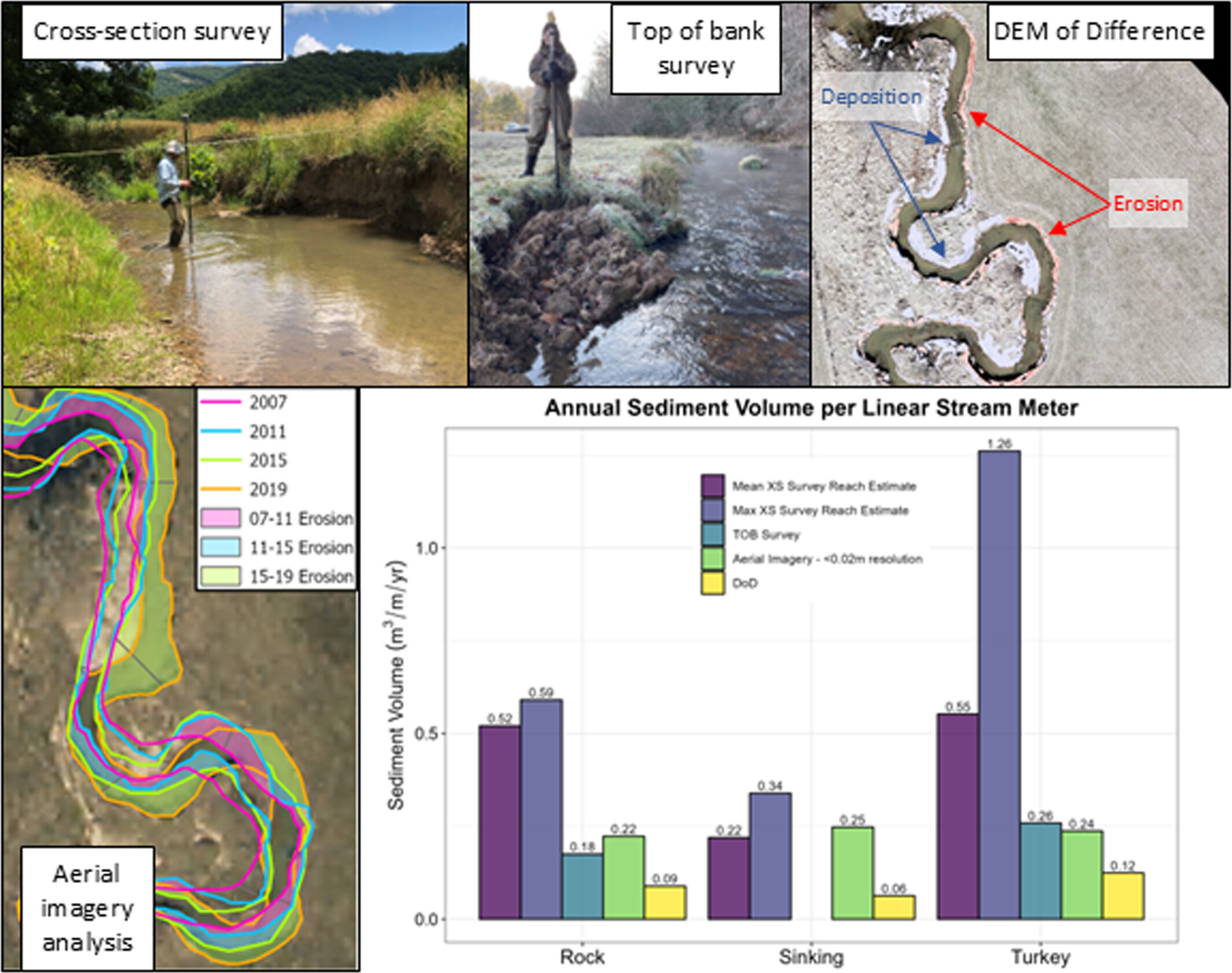
Four methods were used to quantify short-term (1–2 years) reach-wide streambank erosion rates along three low-order streams in western Virginia: (1) bank height and cross-section (XS) surveys, (2) bank height and top of bank (TOB) surveys, (3) bank height survey and aerial imagery analysis and (4) DEM of Difference (DoD) using UAS LiDAR with channel Geomorphic Change Detection (GCD) software. Results show physical surveys are best for quantifying short-term erosion rates for small, low-order streams in this region.
The feasibility of using national-scale datasets for classifying wetlands in Arizona with machine learning
- First Published: 23 September 2024

The paper describes how existing wetland data can be used to train a random forest ML model in Google Earth Engine and generate an accurate map of wetlands for the U.S. State of Arizona. Methods can be easily applied to other parts of the U.S.
Applicability of the longitudinal profile–based cirque classification—A test with large cirque datasets in the southeastern Tibetan Plateau
- First Published: 23 September 2024
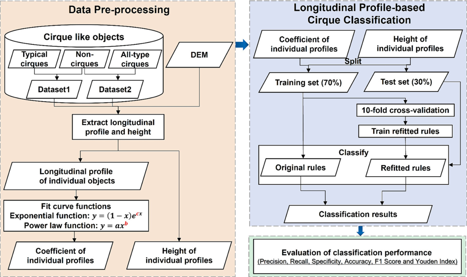
In this study, we verified that the longitudinal profile–based cirque classification method is applicable to classify the relatively large cirque and non-cirque dataset in southeastern Tibetan Plateau, including dataset 1 (256 typical cirques and 101 non-cirques) and dataset 2 (883 all-type cirques and 101 non-cirques).
Dynamics and internal structure of a rock glacier: Inferring relationships from the combined use of differential synthetic aperture radar interferometry, electrical resistivity tomography and ground-penetrating radar
- First Published: 29 September 2024
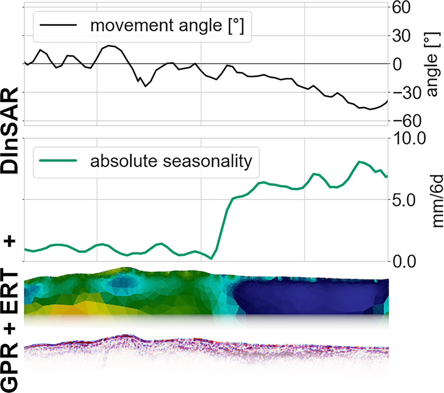
Our study combines geophysical surveys (ground-penetrating radar and electrical resistivity tomography) with surface movement parameters derived from satellite-based differential SAR interferometry. We show that this combination improves the understanding of current geomorphological surface dynamics, as seasonal acceleration and movement angle are sensitive to changes in sub-surface properties.
Automated identification of earthen berms in Western US rangelands from LiDAR-based digital elevation models
- First Published: 03 November 2024
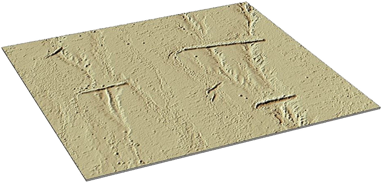
A method for identifying rangeland soil and water conservation structures, such as earthen berms, within high-resolution lidar data is described and evaluated.
Insights into Martian bedform migration: Results from Gale, Jezero and Pasteur craters
- First Published: 04 November 2024
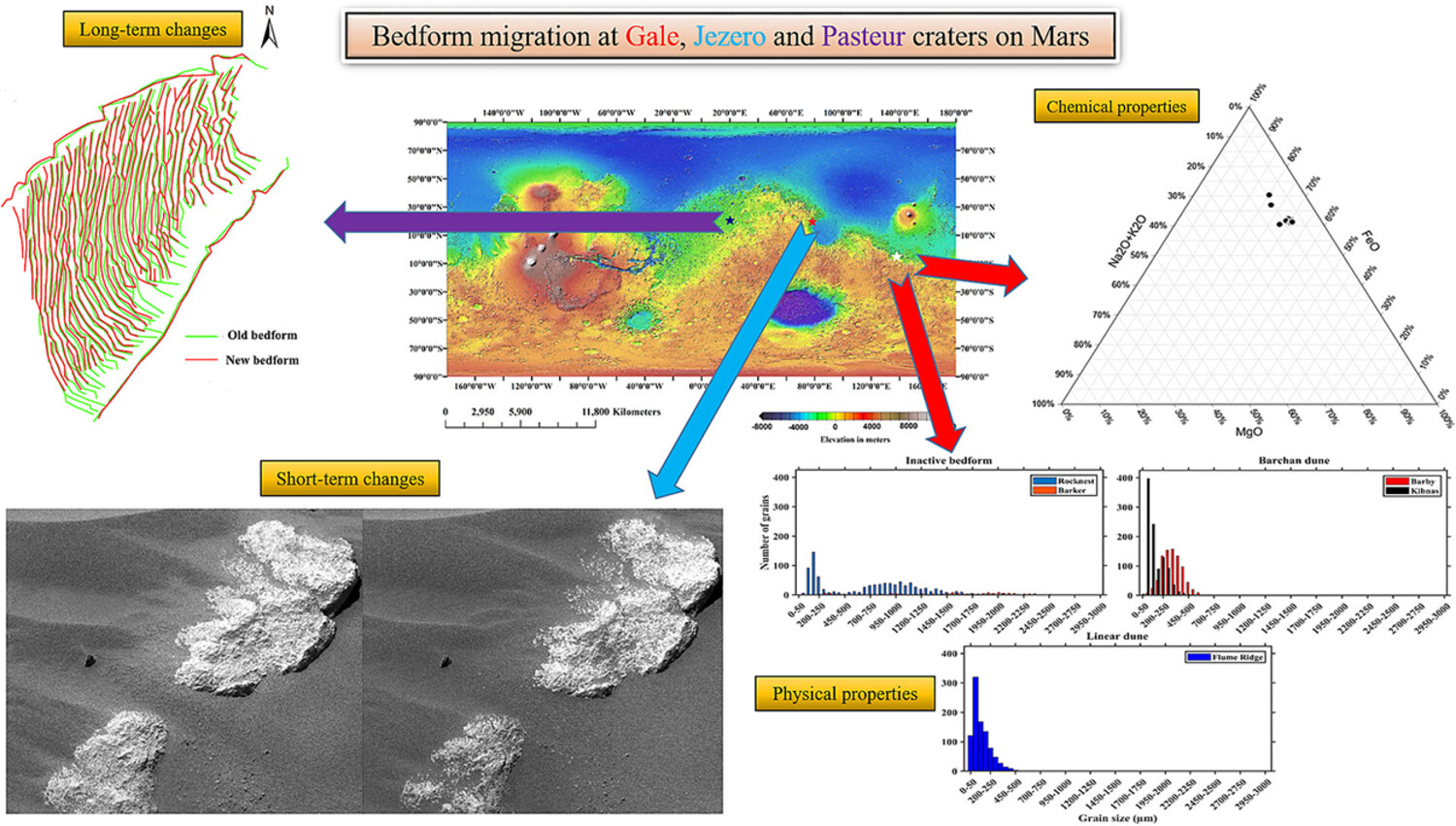
The Martian bedform migration is analysed using satellite and rover observations at Gale, Jezero and Pasteur craters. The results concerning physical and chemical properties indicate short and long-term variability determined by localized aeolian processes. It is essential for understanding the geological history and recent surface dynamics.
Assessing open-access digital elevation models for hydrological applications in a large scale plain: Drainage networks, shallow water bodies and vertical accuracy
- First Published: 20 November 2024
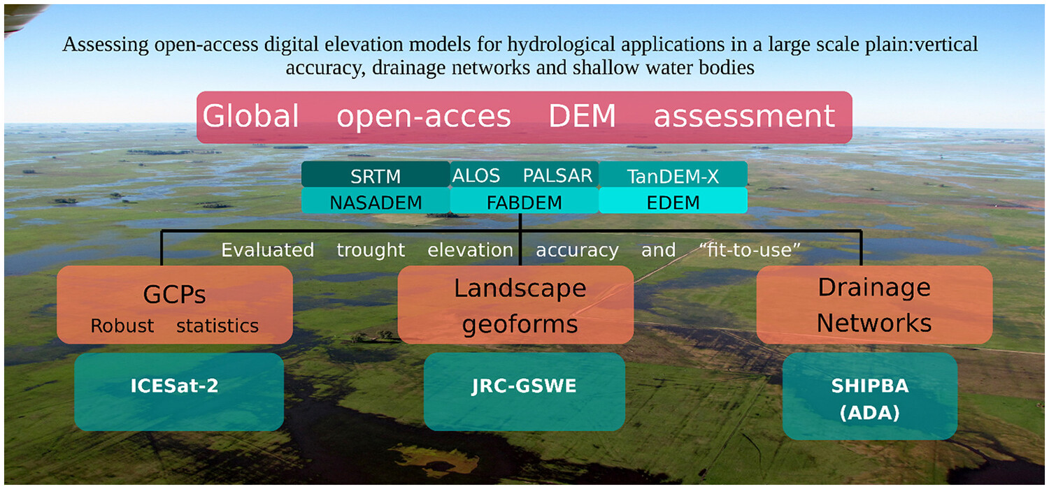
To use open-access DEMs for hydrological applications in large-scale plains, it is mandatory to evaluate them using dense and reliable GCP data, apply appropriate statistical methods, and conduct fit-for-use analyses based on well-documented issues.
Utilizing geospatial tools for the assessment of river bank erosion and migration patterns in complex braided and meandering river systems
- First Published: 03 December 2024
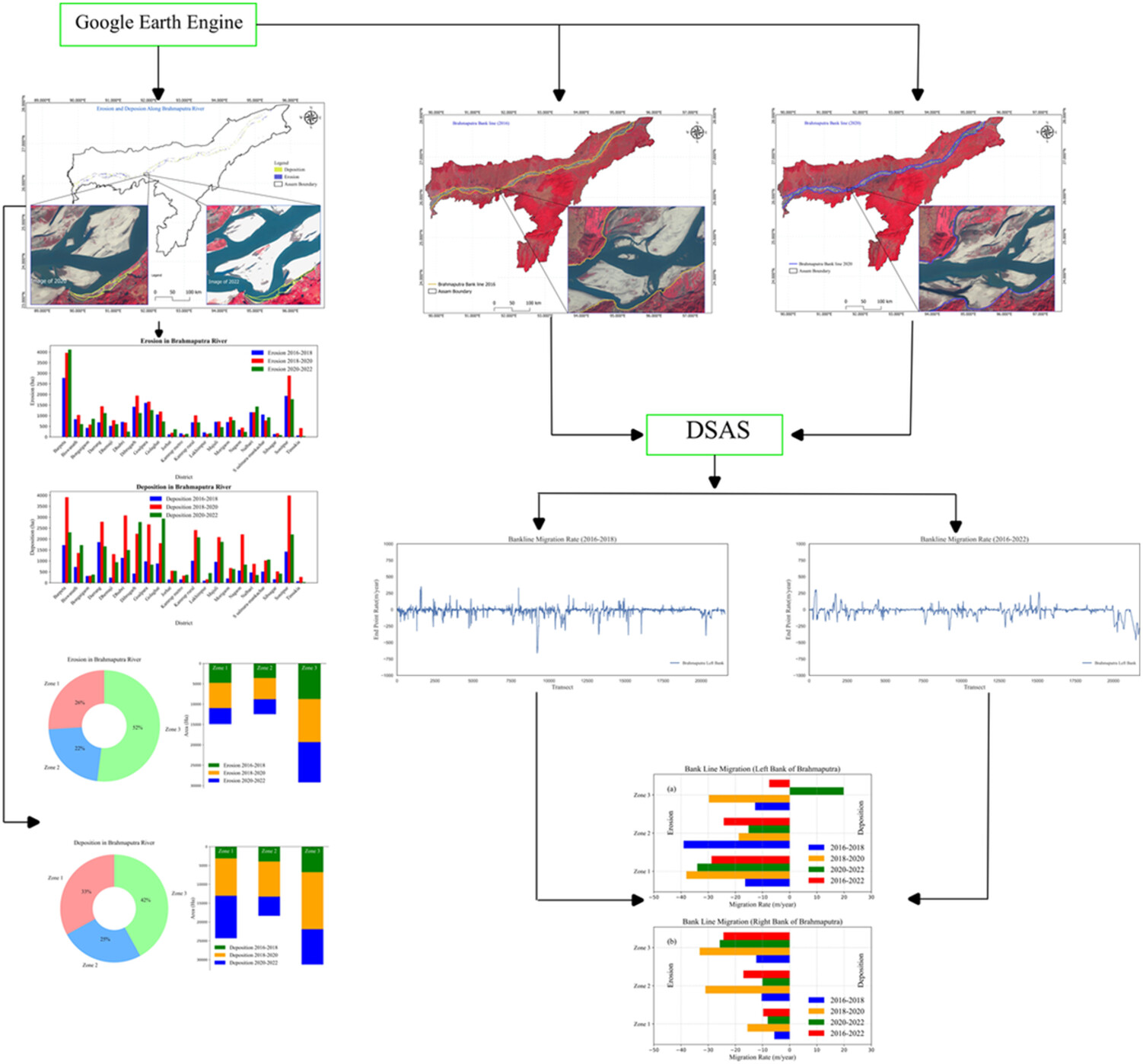
We study the bank erosion and migration in Brahmaputra river (in Assam). The findings are (1) Barpeta district is severely affected, while Tinsukia is the least affected by bank erosion of Brahmaputra river. (2) Brahmaputra experienced both erosion and deposition along its reach. (3) Maximum erosion and migration rate occurred during the period of 2018–2020. (4) During the study period (2016–2022), the left bank of Zone 1 (8440 ha; −28.76 m/year) and right bank of Zone 3 (7640 ha; −24.38 m/year) undergo higher erosion and migration rate, respectively.
Semi-empirically modelling barrier sediment transport in response to hydrodynamic forcing using UAV-derived topographical data (Holgate, New Jersey)
- First Published: 17 December 2024
We developed a semi-empirical model correlating coastal geomorphological change to wave energy and water-level variations. The calibrated model estimates topographical change produced by discrete conditions at Holgate, NJ, demonstrating the potential of our approach for the study of coastal processes and the metrics it can provide to inform coastal management.
Rock glaciers as proxy for machine learning based debris-covered glacier mapping of Kinnaur District, Himachal Pradesh
- First Published: 19 June 2024
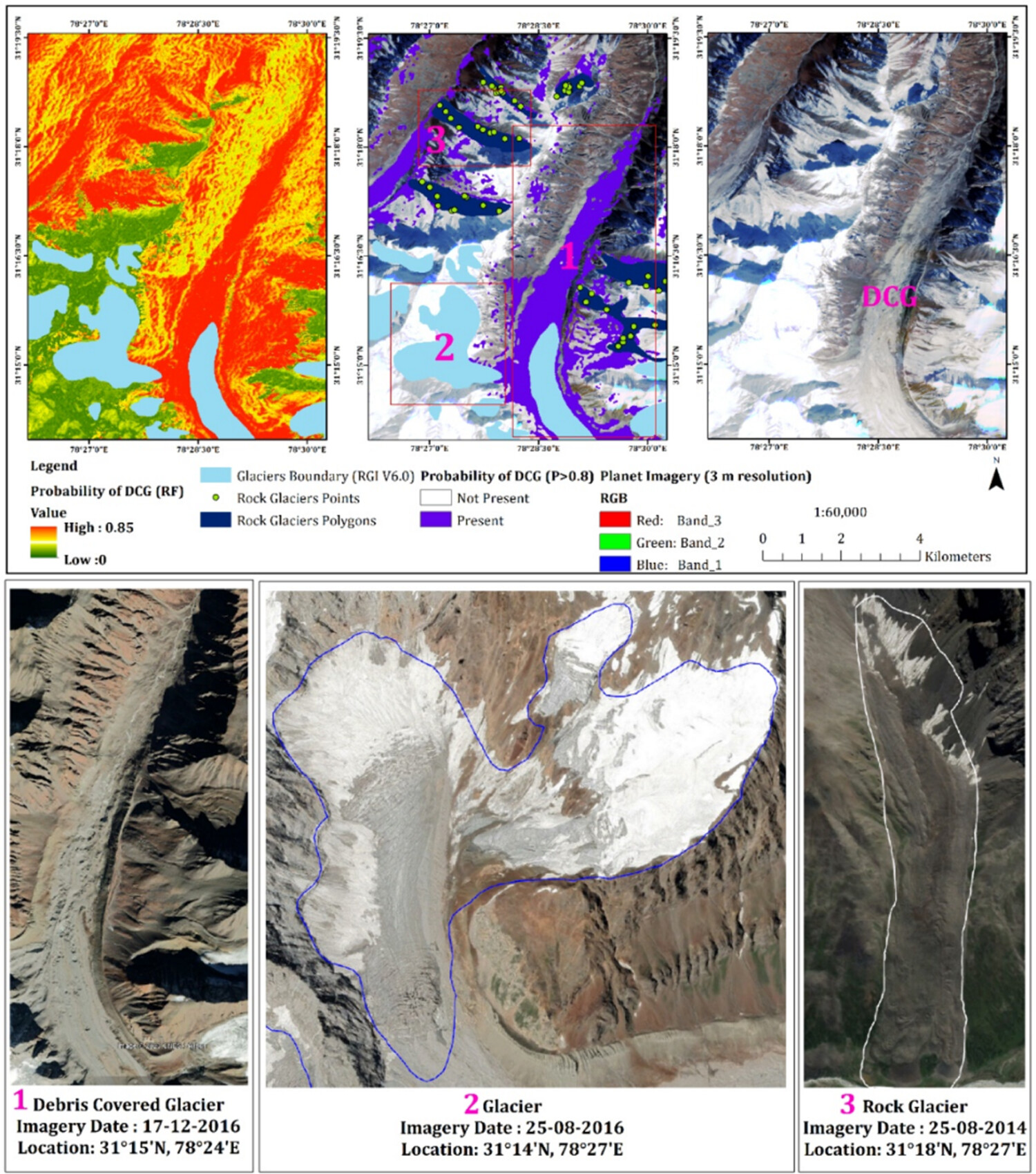
Rock glaciers can serve as a valuable proxy for mapping debris-covered glaciers, as they are interconnected in a continuum, with debris-covered glaciers potentially transforming into rock glaciers over time. Six machine learning models, combined with multispectral satellite and topographical data, are employed to estimate debris-covered glacier extent in Kinnaur district. Random forest performed best among the models, followed by K-nearest neighbours and Naïve Bayes. The combination of machine learning models and rock glacier inventory data proved to be an alternative approach for remote sensing-based accurate mapping of debris-covered glaciers, with potential applications in broader environmental studies and other regions.
Detecting the three-dimensional dynamics of post-dam sandbars from Sentinel-2 time-series images: A case study in the lower Lancang–Mekong River
- First Published: 26 July 2024
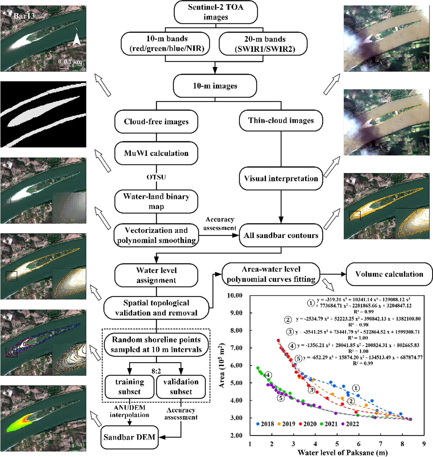
This research revealed interannual area, volume and topography changes of sandbars in different sub-reaches in the lower Mekong River from 2018 to 2022 based on Sentinel-2 imageries. The operation of the Xayaburi Dam and deficient rainfall between 2019 and 2020 have significantly changed erosion and deposition patterns in the lower Mekong River, which were significant global factors contributing to the shrinkage of the sandbars in 2019–2022.
A hierarchical method and workflow for the semi-automated mapping of valley bottom geomorphic units using publicly available remote sensing datasets
- First Published: 04 July 2024
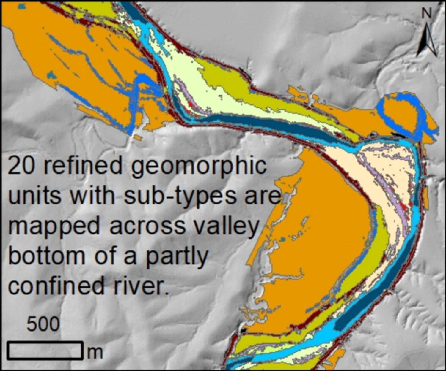
- We develop a hierarchical method to map geomorphic units across valley bottoms.
- The method accommodates user decisions regarding effort invested versus quality and accuracy.
- The method produces 12 preliminary, 20 refined, and four sub-types of geomorphic units.
- The method can be applied to all river types.
Detailed detection and extraction of estuarine tidal channels with multispectral and full-polarised SAR remote sensing
- First Published: 08 August 2024

A new method for detecting and extracting tidal channels using full-polarised SAR, multispectral imagery and machine learning is proposed. This method can extract the tidal channels at the Yellow River Estuary with a resolution of 3 m and an overall accuracy of 99.6%. The method demonstrates the potential to extract high-resolution tidal channels that can be used to advance the monitoring of changes in estuarine geomorphic processes.
Runoff–sediment dynamics and degradation patterns in an abandoned terraced landscape on the Loess Plateau
- First Published: 14 August 2024
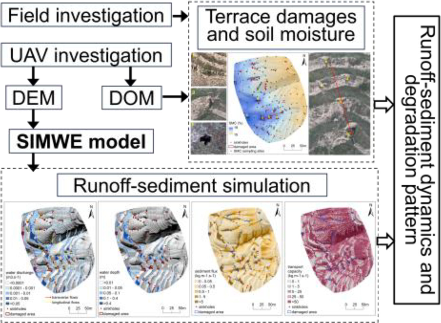
The dominant longitudinal waterflow between terrace steps and converging lateral waterflow along terrace surface control the degradation patterns in the abandoned terraces on the Loess Plateau, and the hydro-geomorphological response is constrained by original slope topography and terrace morphology.
Evaluation of geomorphological classification uncertainty using rough set theory: A case study of Shaanxi Province, China
- First Published: 16 September 2024
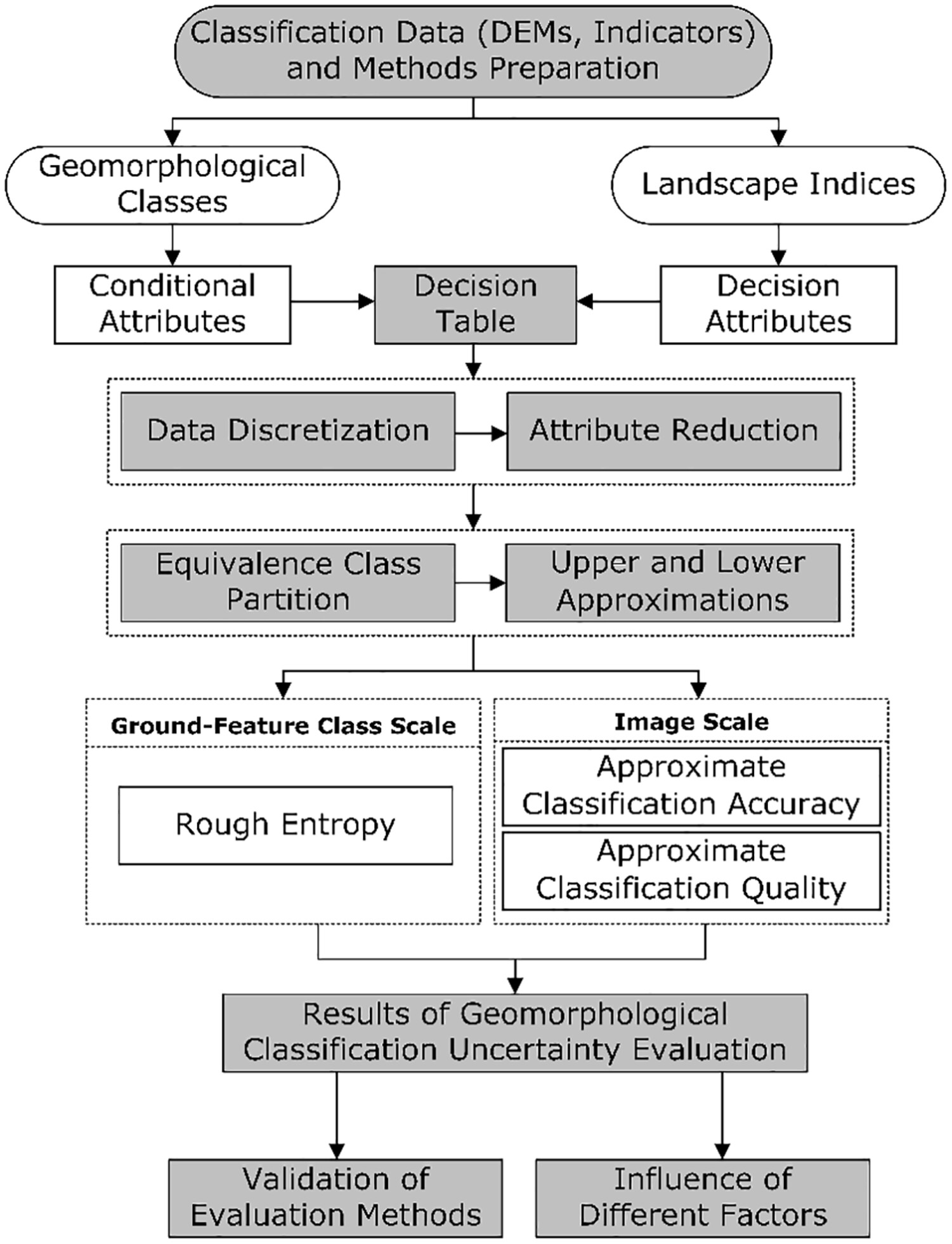
Classification indicators, data resolution, and classification methods (in increasing order of impact) affect the uncertainty of geomorphological classification. We present a guide to choosing the most appropriate method for evaluating the uncertainty of geomorphological classification.
Permafrost thaw and thermokarst in the source region of the Yangtze river in the central Tibetan plateau revealed by radar and optical remote sensing
- First Published: 03 September 2024
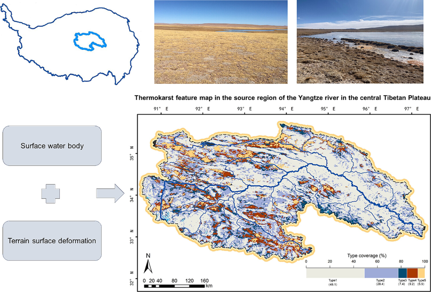
Approximately 50.9% of the Yangtze River source region exhibits evident thermokarst features. Surficial geological factors, specifically geomorphology and slope, are primary factors in shaping thermokarst distribution. In landscapes with thermokarst ponds, both seasonal deformation and long-term subsidence rates intensify, but the amplification diminishes once pond coverage exceeds 5%.
Mio-Pliocene paleo-course of Indus River in Upper Sutlej-Zhada basin: Implication of tectonic uplift on river piracy and drainage reorganization in SW Tibet and NW Himalaya
- First Published: 07 September 2024
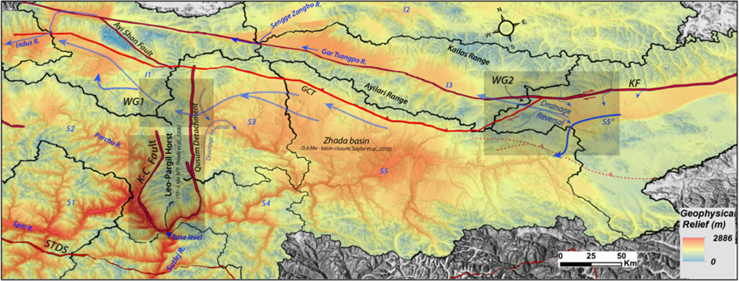
The capture of the proto-Sutlej by the headward eroding Upper Indus River as a consequence of a >1500 m base level change in the Zhada basin exerted an impact on regional growth and tectonics. The gradual expansion of the Leo-Pargil Horst and the ensuing transient uplift-incision regime resulted in the capture of the Zhada paleo-lake ~<5.6 Ma ago. This led to the development of the present Sutlej drainage network with a local base level at the Sutlej and Spiti River confluence.
Consumer-grade UAV solid-state LiDAR accurately quantifies topography in a vegetated fluvial environment
- First Published: 20 April 2023
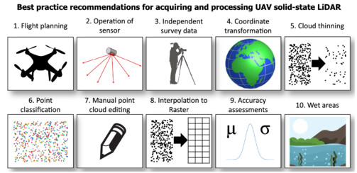
The accuracy of the DJI Zenmuse L1 solid-state UAV LiDAR system is comparable with other aerial-based methods and statistically indistinguishable from detailed ground-based TLS surveys. However, the sensor is unable to penetrate dense ground-hugging vegetation, resulting in elevation bias in these areas. Ten best practice recommendations are provided to assist users of UAV solid-state LiDAR to produce bare earth DEMs in fluvial environments.
Karst landform classification considering surface flow characteristics derived from digital elevation models
- First Published: 03 October 2023
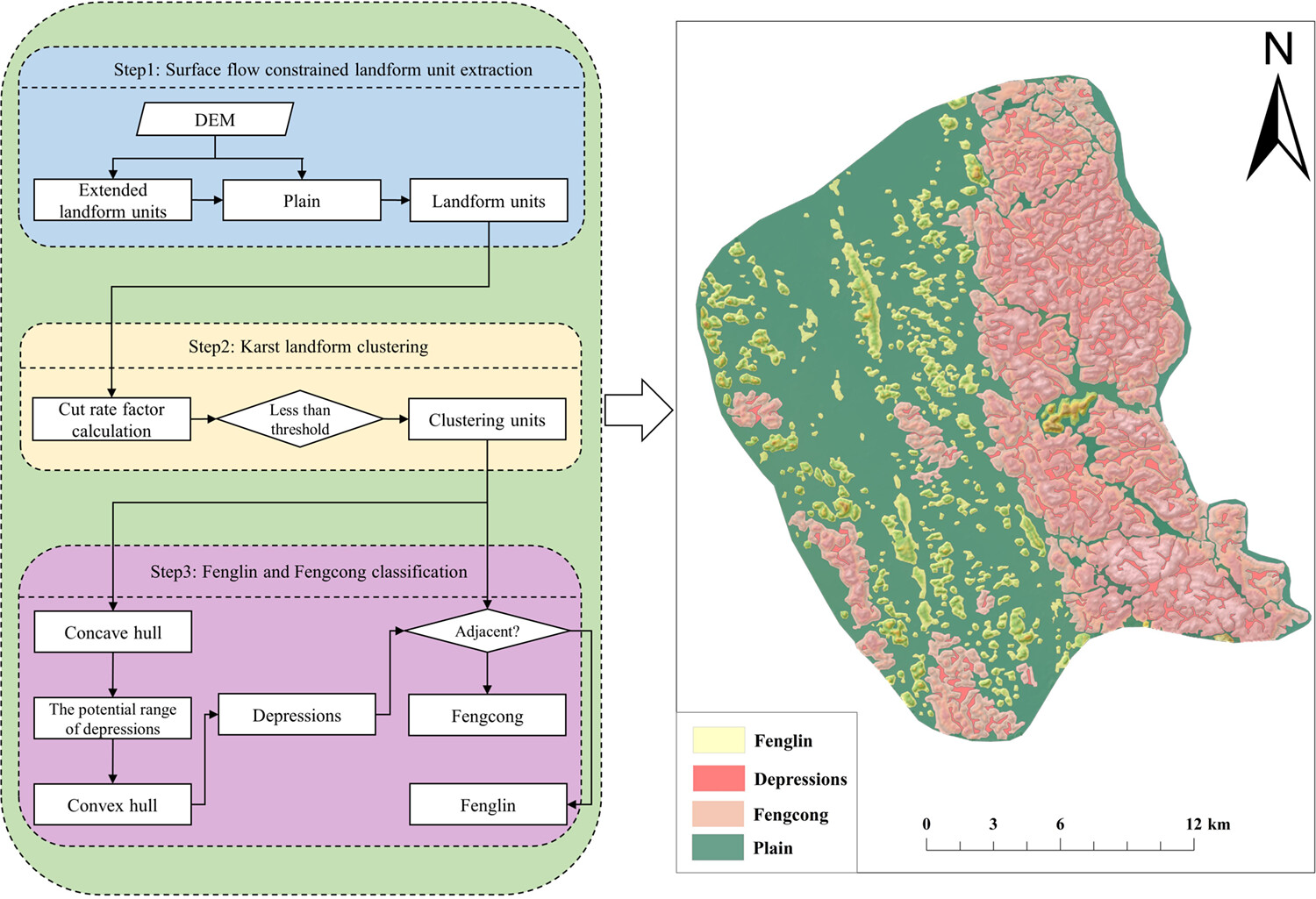
Karst landforms are one of the typical geographical units with a specific physical process on the earth's surface. In this study, we proposed a method considering surface flow for karst landform classification. The proposed approach is validated and applied in two sample karst areas, Fenglin and Fengcong, located in Guilin, China. The results demonstrated that the karst landform units of Fenglin and Fengcong can be effectively classified. The proposed method can be extended to other landform types with complex landforms.
Comparison of different open-source Digital Elevation Models for landslide susceptibility mapping
- First Published: 08 February 2024
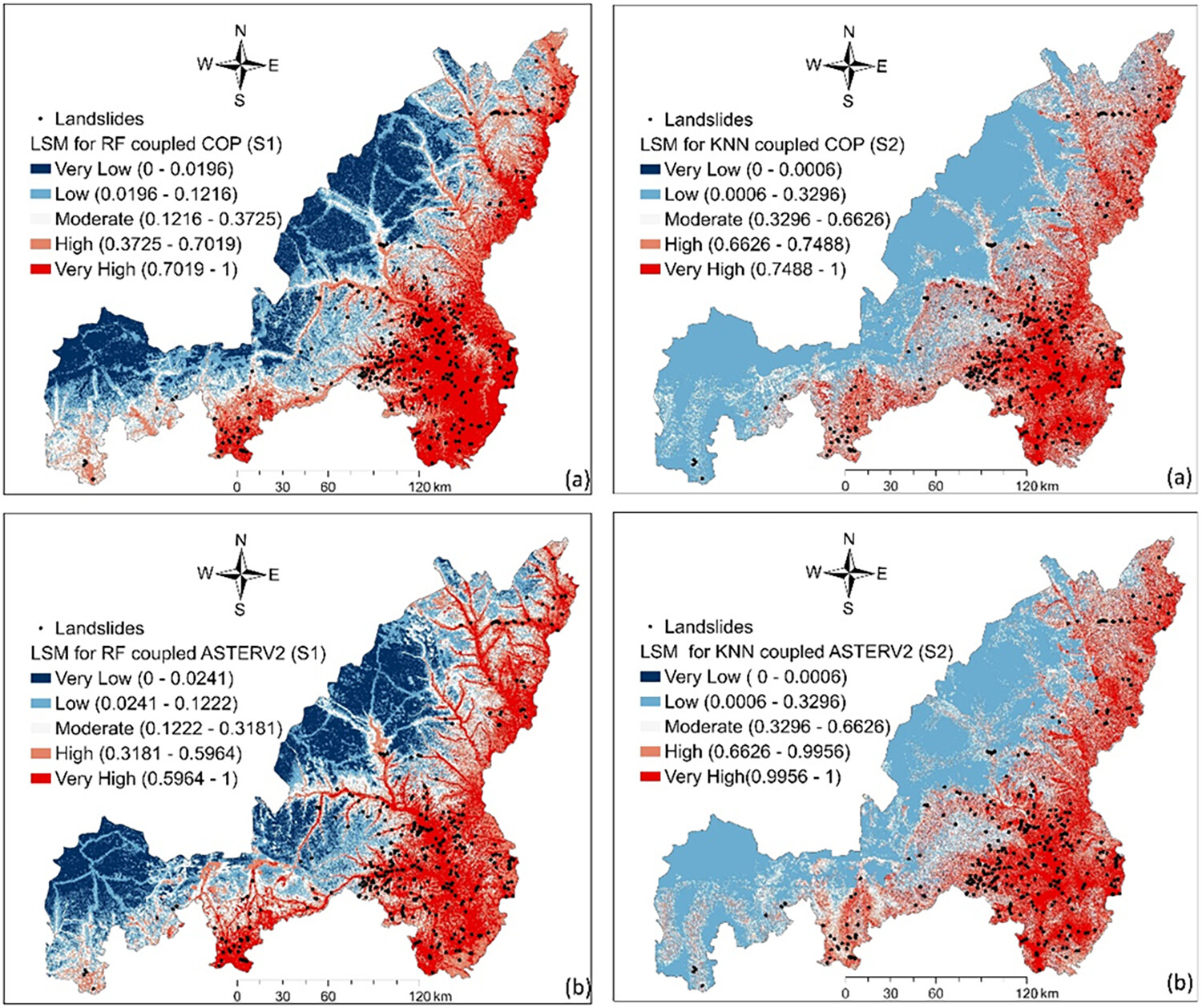
Two machine learning methods, K-Nearest Neighbours (KNN) and Random Forest (RF), were employed to compare the disparities among commonly used open-source digital elevation models (DEMs) in landslide susceptibility mapping. The study revealed significant differences among the DEMs, with the Copernicus DEM 30 m (referred to as COP) emerging as the most recommended option due to its superior rendering performance and stability.
Sign up for email alerts
Tools
More from this journal
- Award Winners
- Special Issues
- State of Science
- Call for Papers - Special Issue: The geomorphic signature of marine and continental Quaternary deposits
- Call for Papers - Special Issue: Earth surface processes and climate change at the Earth’s three poles
- Call for Papers - Special Issue: Novel approaches to quantify landscape changes (Cuchlaine King Symposium 2023)
- Call for Papers - Special Issue: Extreme Events in Geomorphology (Cuchlaine King Symposium 2024)
- Call for Papers - Special Issue: Applications of Artificial Intelligence in Geomorphology
- Call for Papers - Special Issue: Influence of tectonics and climate on landscape evolution: process and modelling
- Call for Papers - Special Issue: Fluvial processes and landforms in the Tibetan plateau in a period of rapid climate change
- Call for Papers - Special Issue: Wood in World Rivers 5
- Call for Papers - Spatial and temporal evolution of landslides induced by global climate change
- Call for Papers - Earth-Surface Processes in the Anthropocene: Human Impact, Climate Change, and Geomorphological Responses
- ESEX Commentaries
- BACKFILES An Online Archive from 1976 to 1995
- Other Resources
Latest Virtual Special Issues:
Is there a geomorphological case for the Anthropocene?
Chaired by Stephen Tooth, with panellists Professor Tony Brown, Simon Price and Professor Andreas Lang. Are we in the Anthropocene and no longer in the Holocene? Has human activity integrated and changed natural processes? Have we created our own geological time period?