

Journal list menu

 Issue
IssueHydrological Processes: Volume 38, Issue 8
August 2024
Export Citations
Download PDFs
ISSUE INFORMATION
RESEARCH ARTICLE
Bofedal wetland and glacial melt contributions to dry season streamflow in a high-Andean headwater watershed
- First Published: 07 August 2024
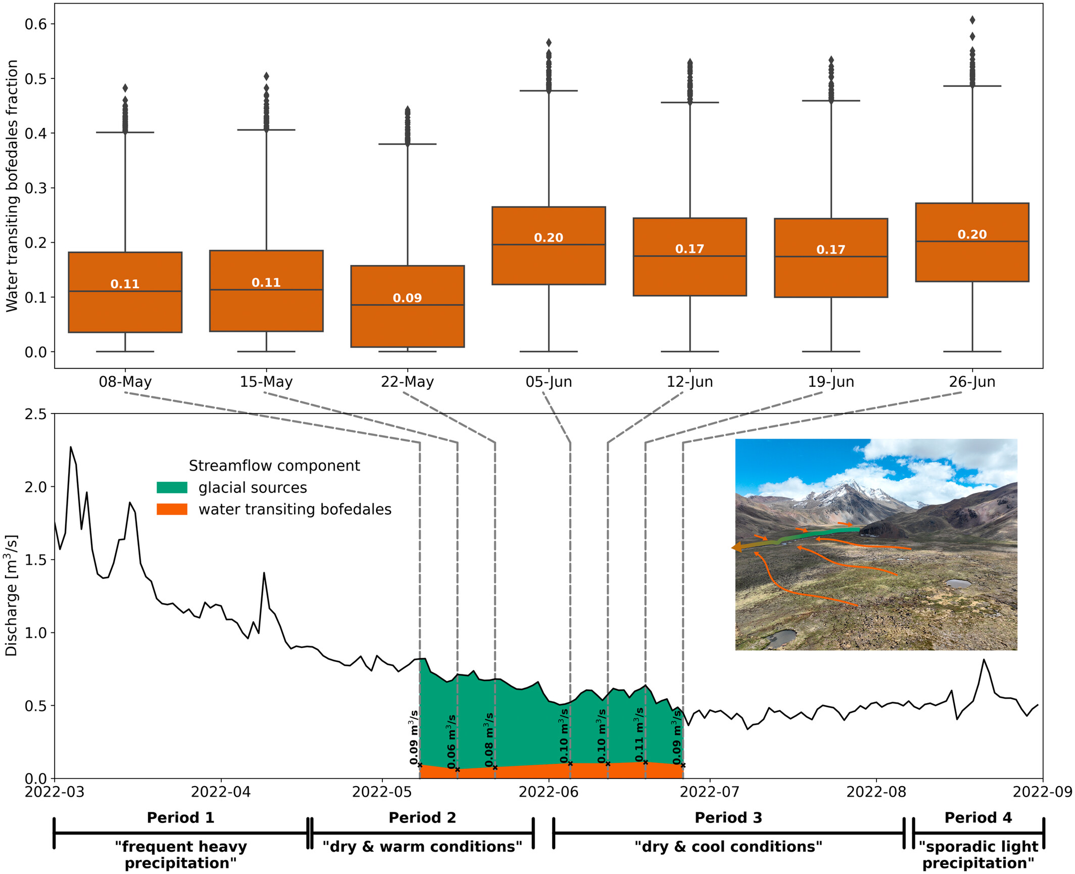
Isotopic signatures indicative of evaporative flowpaths have been previously identified in high-Andean surface waters, however data scarcity has prevented source attribution and streamflow separation. Here, end-member sampling in a glacierized headwater catchment shows consistent wetland contributions to streamflow during extended dry conditions whilst glacial melt contributions vary more considerably. The results emphasize the importance of valley-bottom wetlands and the connected groundwater system in a rapidly deglaciating landscape.
Comparison of different techniques in determining groundwater levels trends in Türkiye
- First Published: 07 August 2024
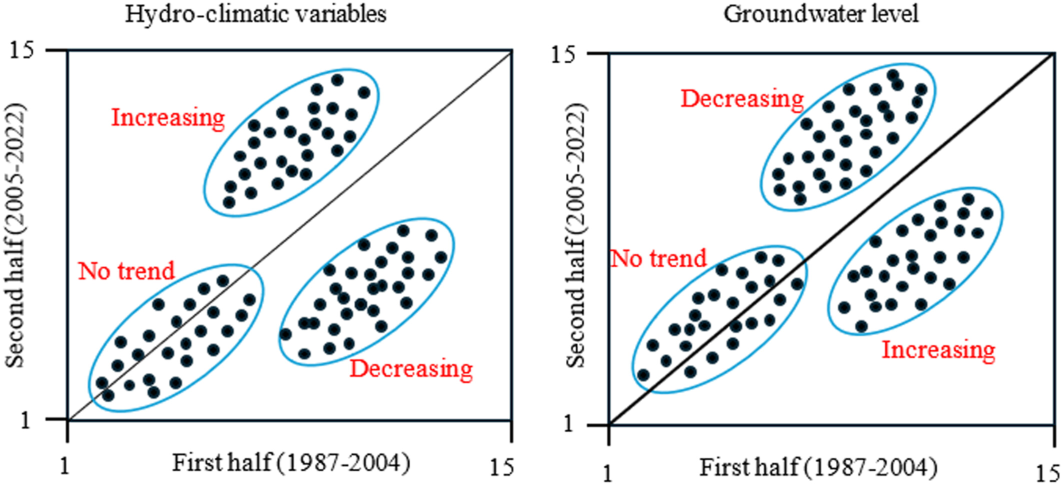
- GWL trends are analysed at the monthly, seasonal, and annual scales using a combination of techniques, such as Mann-Kendall, Sen's Slope, Innovative Polygon Trend Analysis (IPTA), and Innovative Trend Analysis (ITA), using data monitored between 1987 and 2022 in seven wells in Turkey.
- Trend analysis will allow for evaluating differences among commonly used methods in investigating GWL levels, eventually providing insights on critical areas to prioritize interventions.
- Besides analysing trends, a homogeneity analysis was conducted to detect change points in groundwater levels.
Predicting soil erosion risk using the revised universal soil loss equation (RUSLE) model and geo-spatial methods
- First Published: 07 August 2024
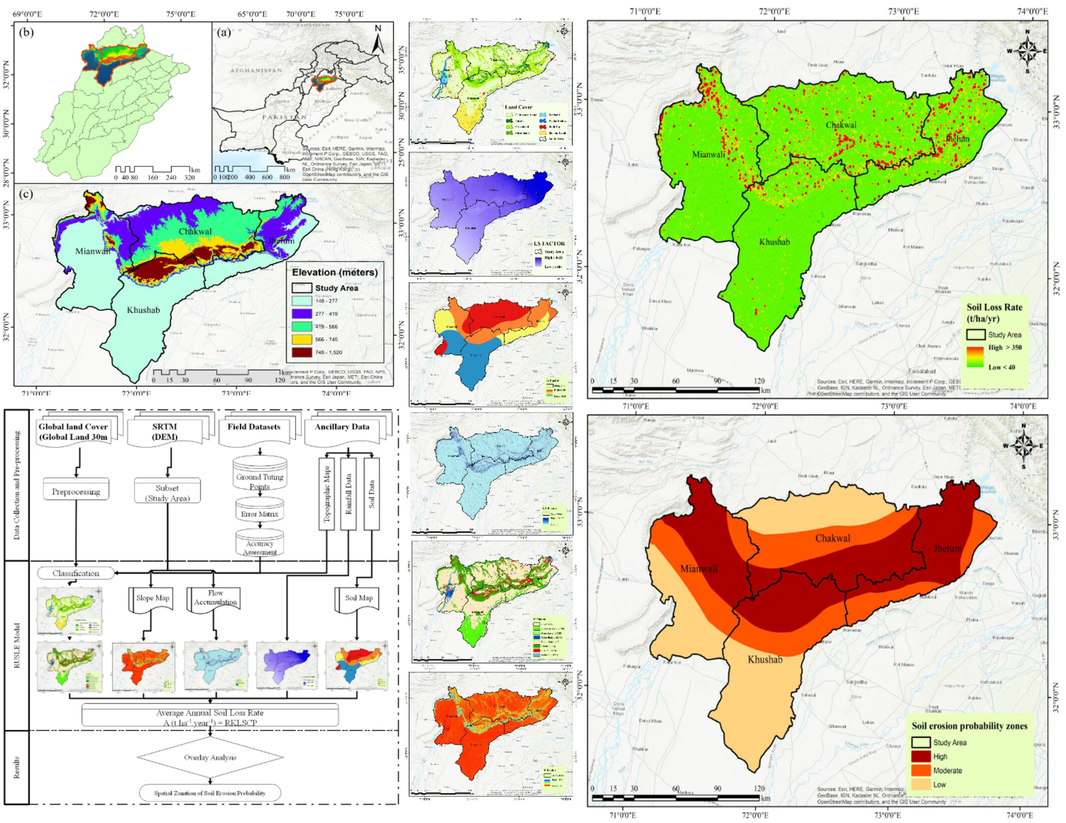
This study employs the RUSLE model alongside RS and GIS to analyse soil erosion in Salt Range, Potohar Plateau, Pakistan, identifying significant annual potential soil loss rates. Findings categorize erosion risk into five classes, highlight areas needing urgent conservation, and support sustainable land management strategies. The integration of these technologies provides essential insights for achieving Sustainable Development Goal 2 (Zero Hunger) by safeguarding food security through improved land management.
Forest cover lessens hurricane impacts on peak streamflow
- First Published: 26 August 2024
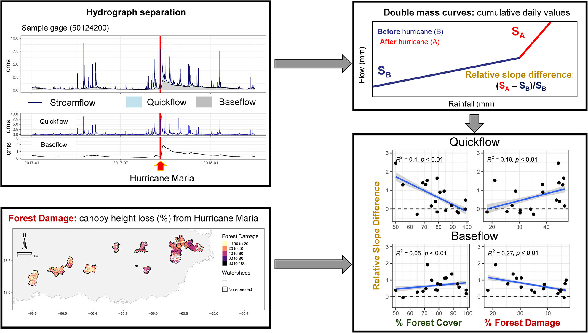
We quantify streamflow component changes following a severe hurricane and relate these changes to watershed forest cover and canopy damage. Several watersheds displayed higher post-hurricane quickflow and baseflow, however, the response was variable. Quickflow increases were greater in watersheds with high forest damage. Under the same level of relative damage, watersheds with low forest cover had greater quickflow increases than highly forested ones. Conversely, baseflow increases were greater in highly forested watersheds and smaller in highly damaged watersheds.
Projections of rain-on-snow events in a sub-arctic river basin under 1.5°C–4°C global warming
- First Published: 07 August 2024
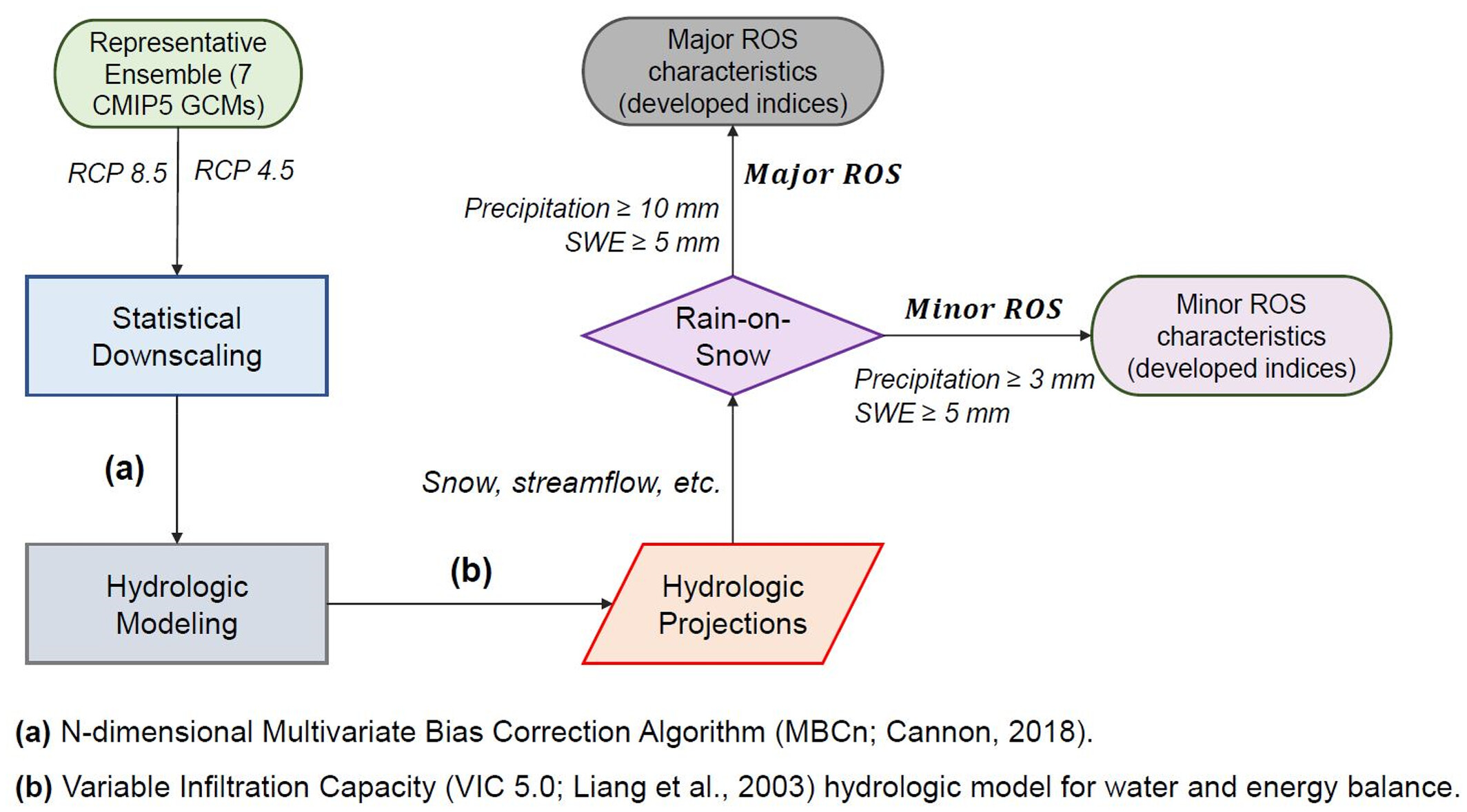
We evaluate the impact of rain-on-snow (ROS) events under global warming conditions at the watershed scale in a sub-arctic area. We categorize ROS into minor and major events and develop seven indices to characterize these occurrences. Our findings project an increase in the frequency of ROS days during the fall in a warmer climate, along with an expectation of more severe ROS events in the spring, driven by heightened rainfall intensity due to warming. In comparison to minor ROS, major ROS events have the potential to generate increased runoff and snowmelt.
Icings as sentinels and modifiers of water flow through winter landscapes: An exploration of physico-chemical processes on the lake-dominated, discontinuous permafrost Taiga Shield
- First Published: 27 August 2024
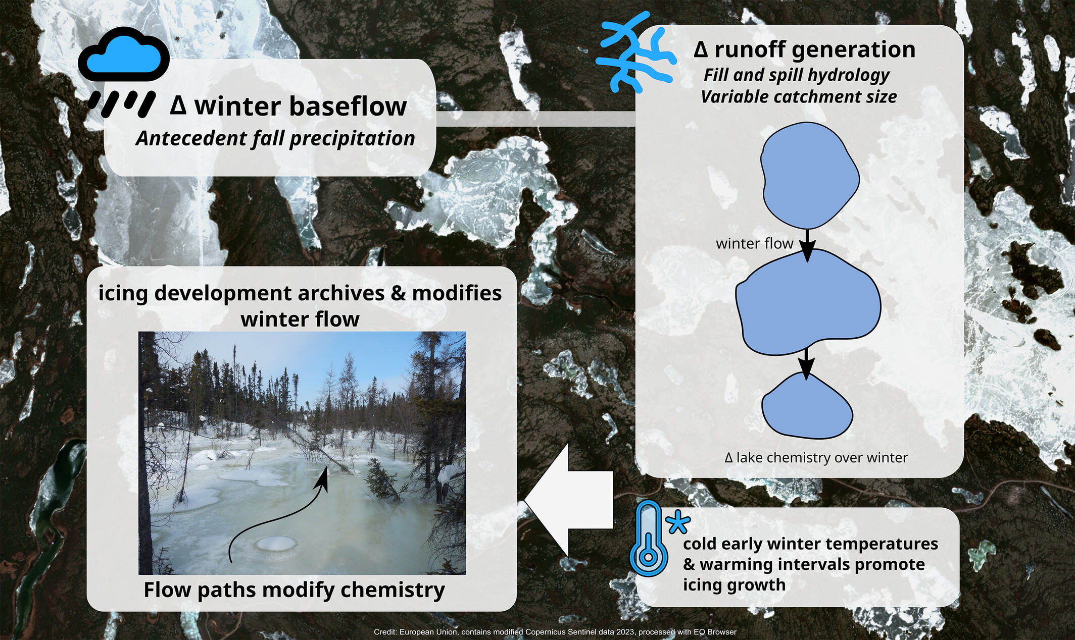
On the discontinuous permafrost Taiga Shield, wintertime icings require sufficient antecedent (summer–autumn) precipitation or upstream basin storage to form. Icing formation and growth require cold early-winter temperatures accompanied by warming intervals; sub-zero warming intervals can enable substantial water pulses before the spring freshet. Icing chemistry reflects the often-variable chemistry of icing source water, but solute exclusion causes icing growth to actively enhance the solute concentration of wintertime flow.
Effects of straw application on soil hydrothermal conditions and crop yield in a maize and wheat rotation system
- First Published: 07 August 2024
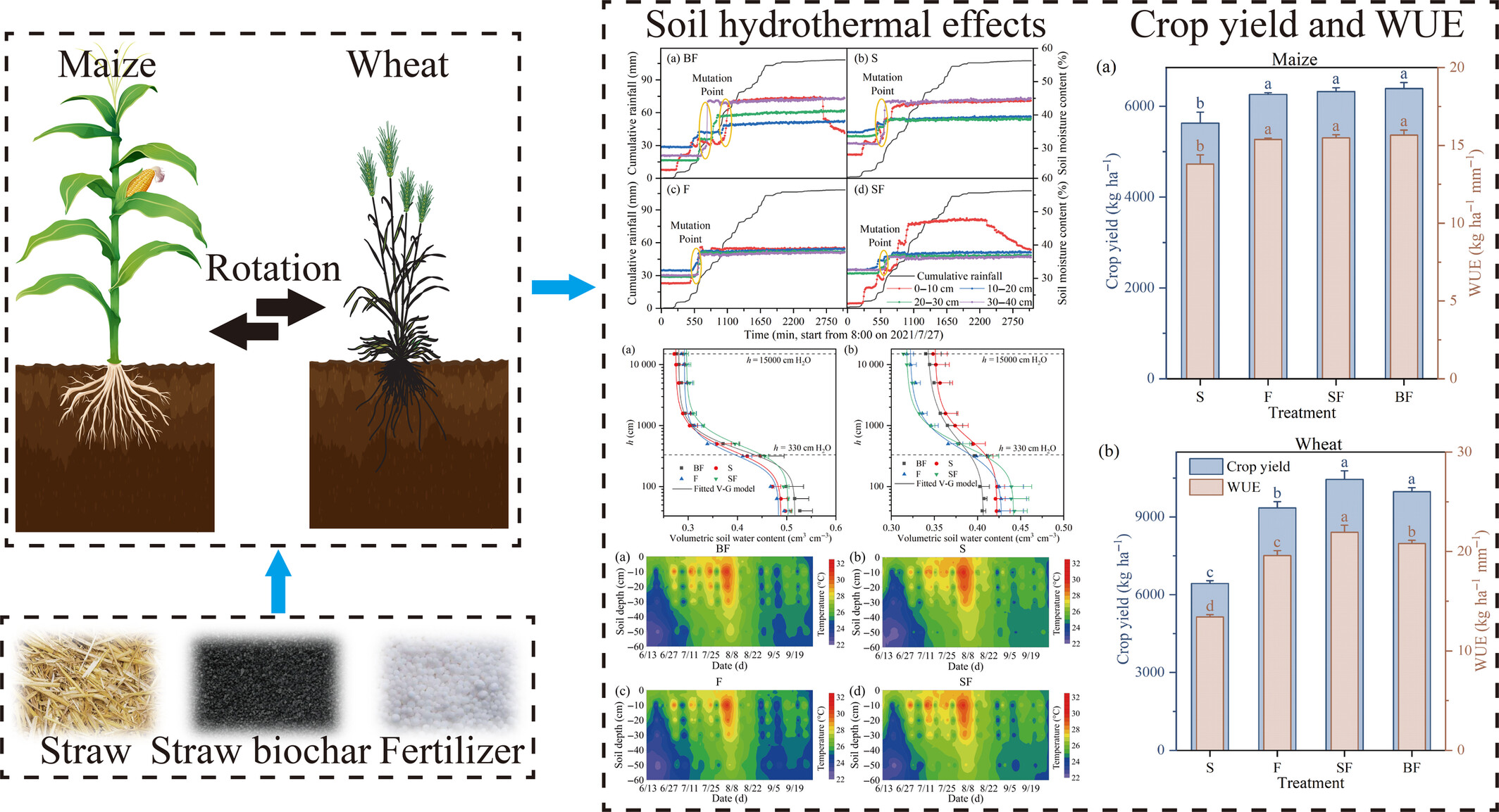
Straw biochar with fertilizer (BF) and straw with fertilizer (SF) treatments improved soil structure, increased soil water storage and rainfall storage efficiency, and advanced the response time of soil water to rainfall by 4 h. BF and SF treatments significantly promoted wheat growth, grain yield and water use efficiency but had no significant effect on maize. SF treatment had a good effect on soil moisture and nutrient improvement, and grain yield water use efficiency was the highest.
Study of the effect of local forcing on the fractal behaviour of shallow groundwater levels in a riparian aquifer
- First Published: 07 August 2024
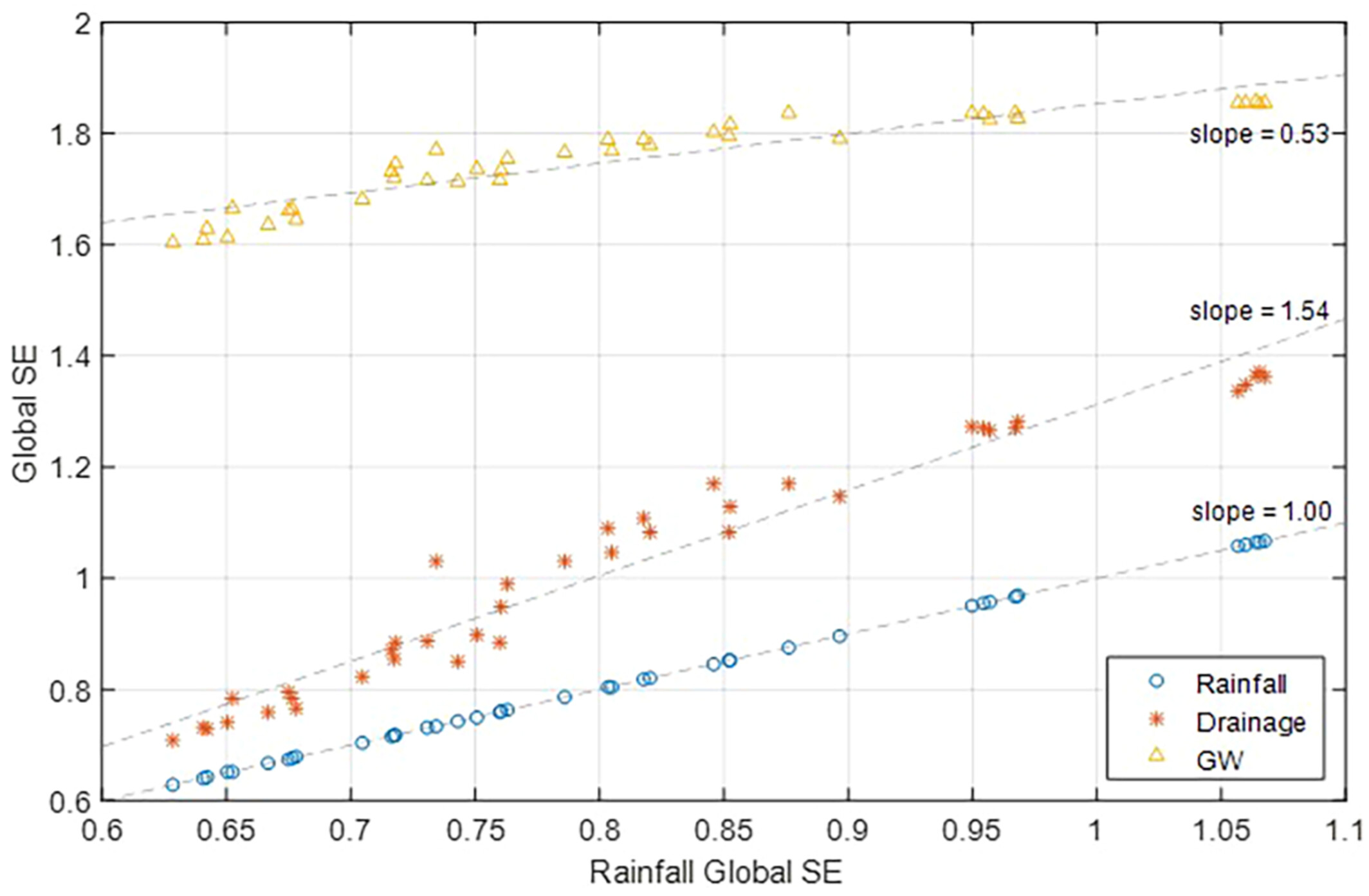
Sensitivity of groundwater levels' fractal behaviour to catchment-scale forcing is studied using a physically based groundwater flow model and a multiplicative random cascade model to simulate rainfall forcing of different fractal behaviour. Interestingly, it is found that changes to the fractal behaviour of drainage is higher than that of rainfall forcing and resulting groundwater levels' as shown in the graphical abstract.
Dynamic response of groundwater to rainfall events and sea tides in coral island
- First Published: 07 August 2024

The fresh groundwater periodically fluctuates with phase lags every 1–2 h following sea tides. Only in case of severe rainstorm (cumulative precipitation of an event above 300 mm), the contribution of rainfall on groundwater level fluctuation is greater than that of sea tide. Four response modes (RRR, RFF, RFR, RRF) decomposition of groundwater have been defined according to the tidal stage and threshold of rainfall.
Understanding satellite-derived groundwater dynamics and its association with hydrological processes over India during excess and deficit monsoon years
- First Published: 07 August 2024
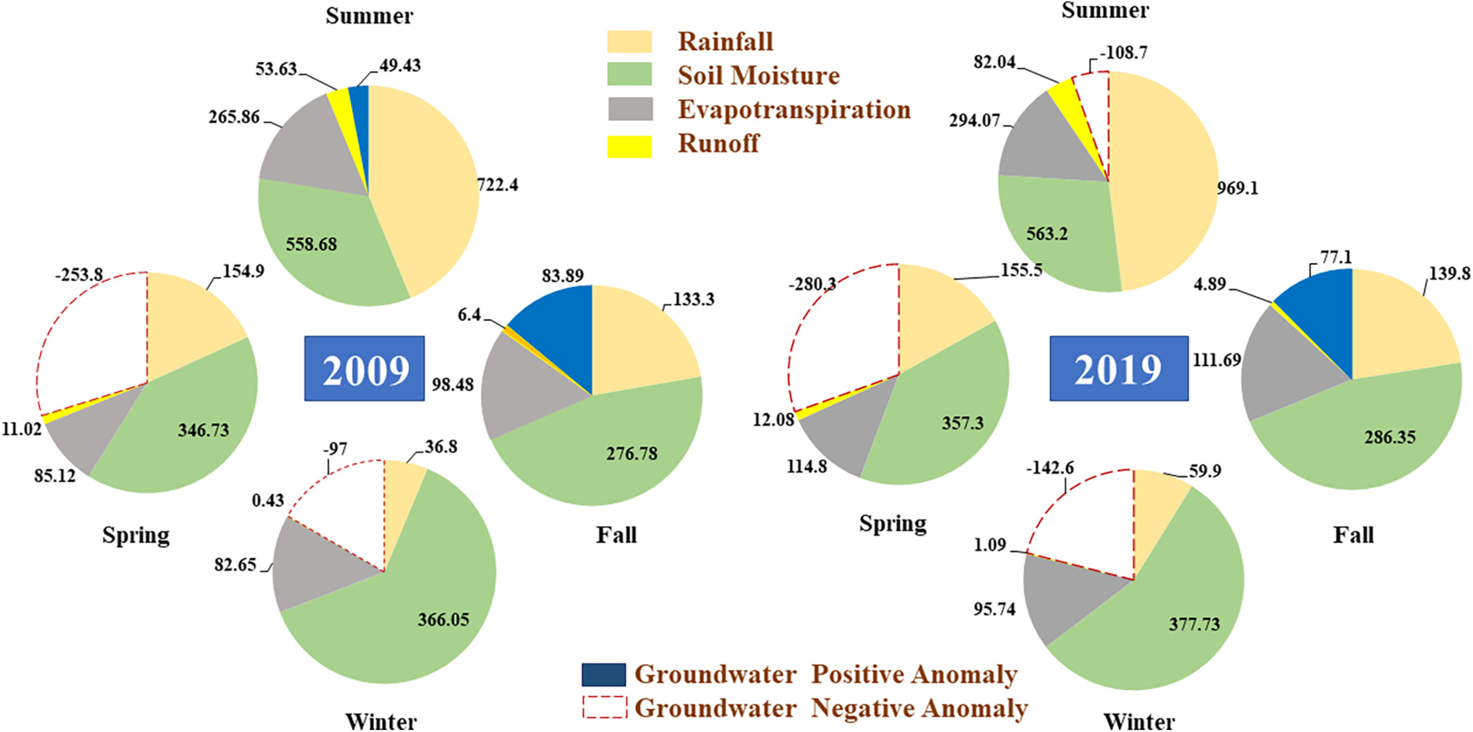
Hydrological variables exhibit higher seasonal variations during the summer season (June to September), whereas groundwater anomalies show maximum variation across India in the Fall season (October to November). The decline in groundwater storage is observed in most parts of the country during the winter season (December to February), and it is lowest in the spring season (March to May). An increase of 34.46 mm and 185.8 mm in GWA can be seen in the fall from the summer season in the deficit and excess monsoon years, respectively. It can be concluded that the groundwater is replenished in the excess monsoon year, however, the highest negative GWA is observed due to an increase in evapotranspiration, unsaturated soil moisture, and runoff and preceding spring GWA.
Exploring hydrological dynamics of layered pyroclastic soils by combining laboratory and field experiments with a numerical model
- First Published: 08 August 2024
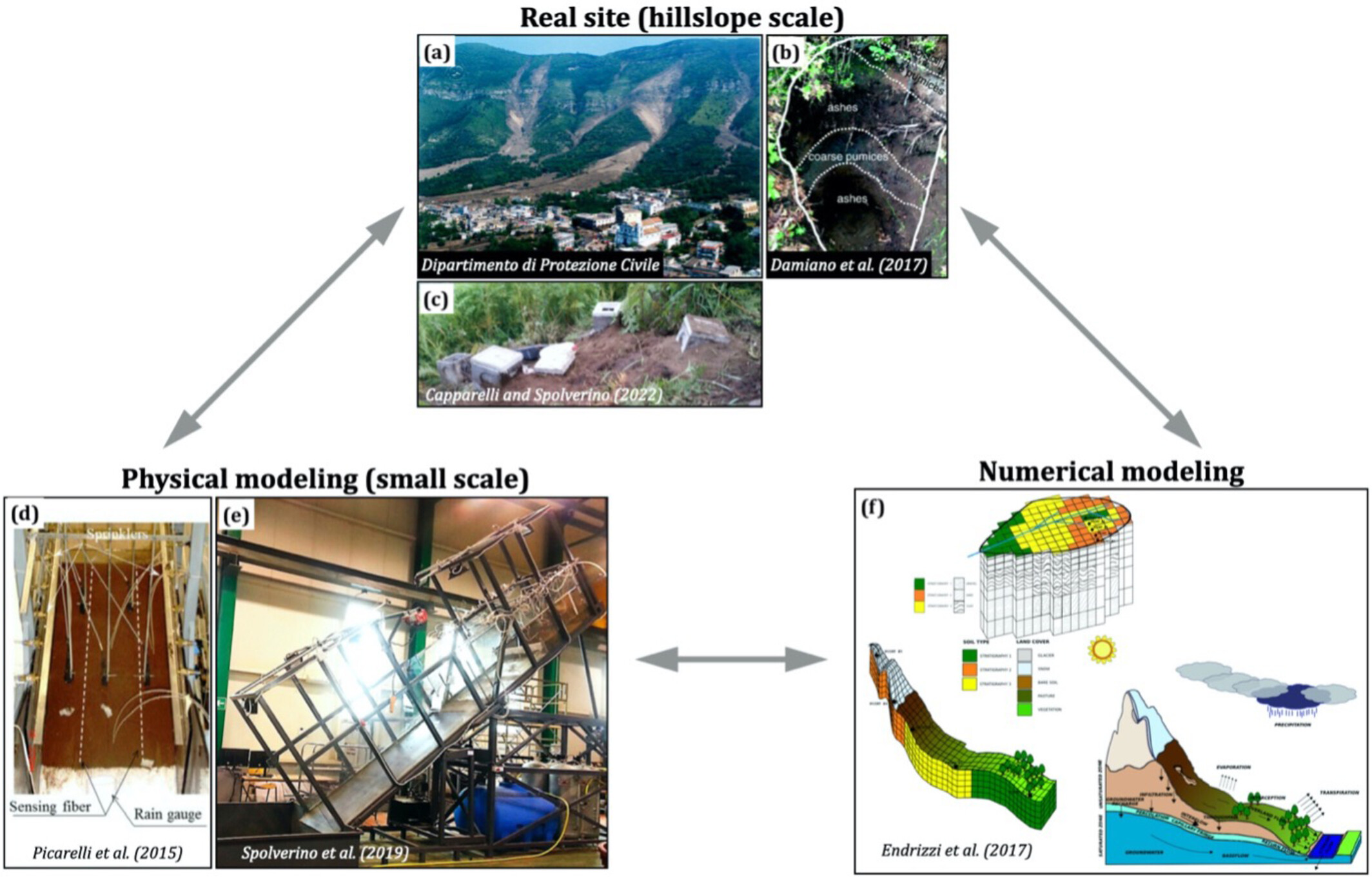
Combining physical model and in situ measurements of soil water content and soil water pressure together with a 3D hydrological models, we detailed and disentangled the infiltrations processes trough layered pyroclastic soils. The finding will be relevant for accurate geo-hydro risk management in a changing climate.
Hydrohill: A landmark public work created by Wei-Zu Gu that advances experimental hydrology
- First Published: 18 August 2024
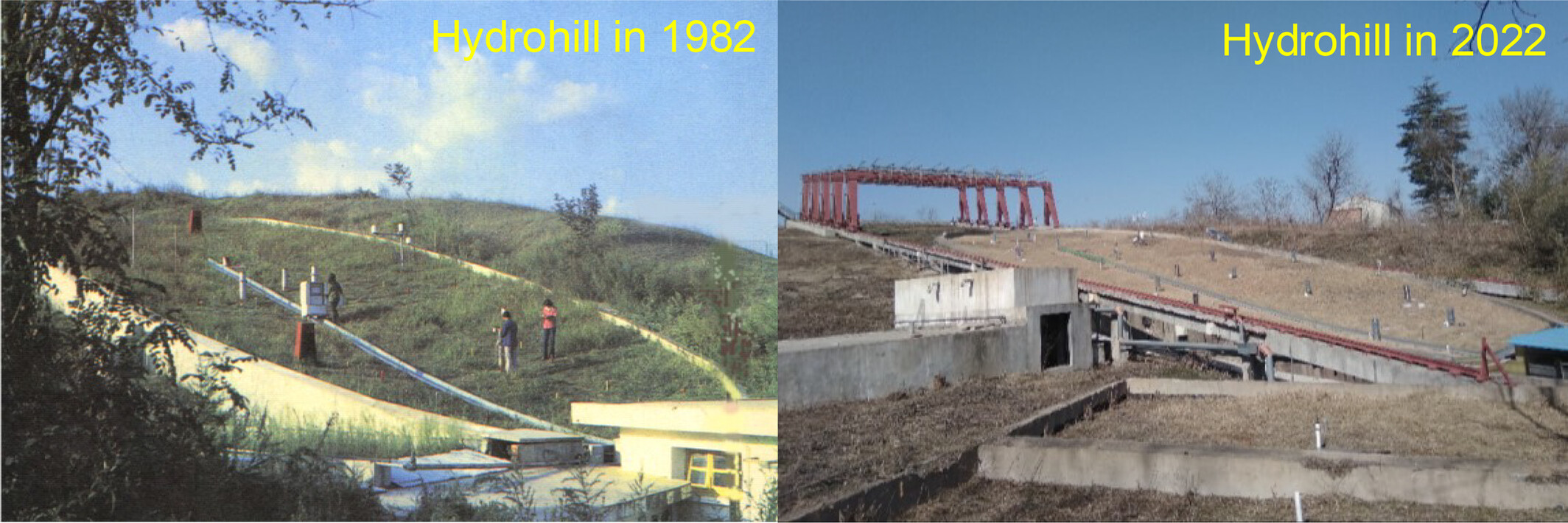
The Hydrohill, created by Professor Wei-Zu Gu for experimental hydrology, is a great public work that deserves an in-depth presentation. It is an innovative infrastructure that bridges the gap between natural watershed experiments and artificial physical models. The Hydrohill's brief history, experimental objectives, site description, site conditions and contributions to hydrologic science are presented to the hydrologic community.
Spatio-temporal analysis of snow depth and snow water equivalent in a mountainous catchment: Insights from in-situ observations and statistical modelling
- First Published: 20 August 2024
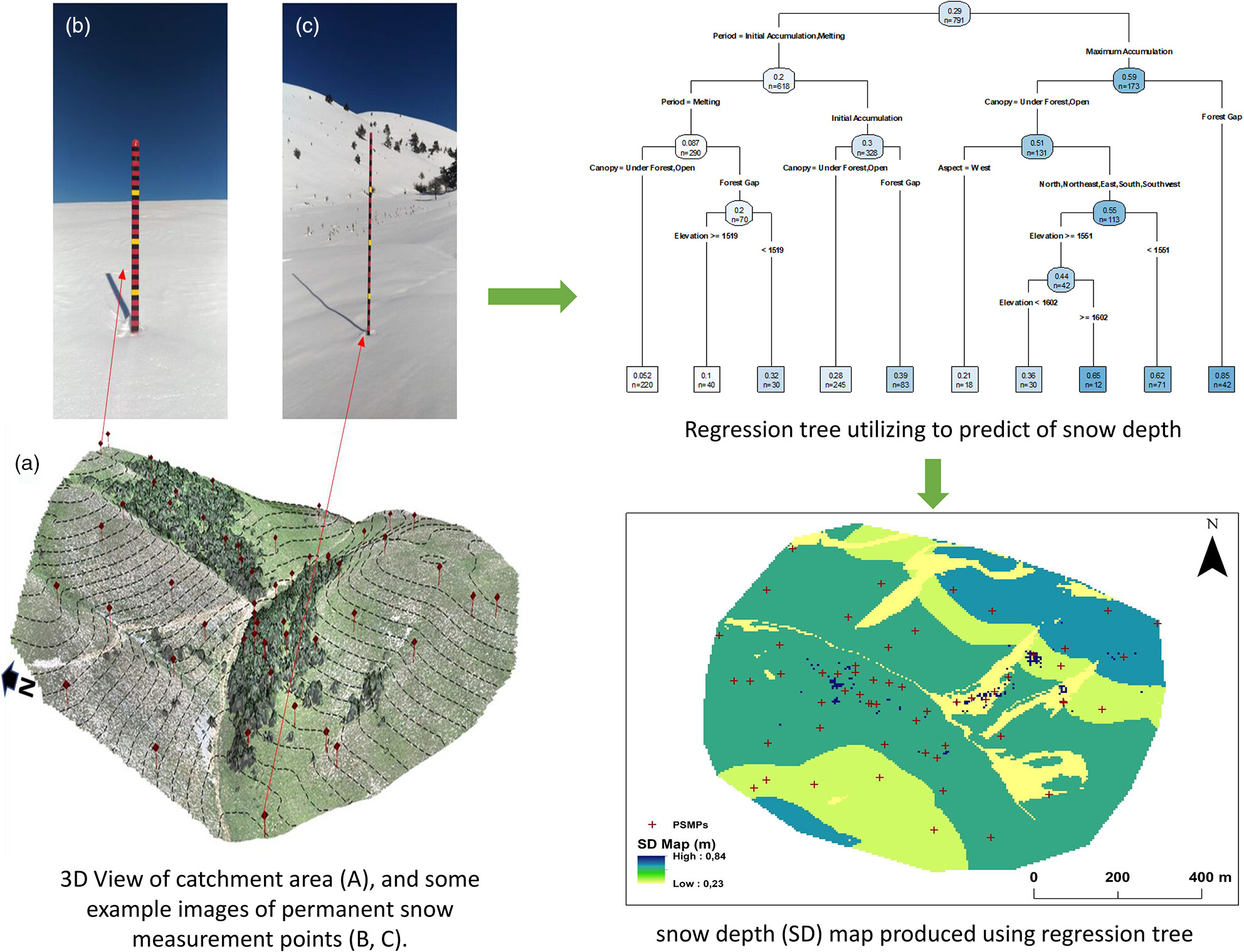
The spatio-temporal dynamics of snow depth (SD) and snow-water equivalent (SWE) investigated in a mountainous catchment (a). Classification and regression tree method (CART) was employed to analyse the interactions of SD and SWE with the selected variables. The findings underscored the role of forest canopy in reducing SD and SWE. The influence of wind resulted in less snow accumulation in open areas compared with forest gaps. The snow cover disappeared earliest in under-forest areas. CART analysis results highlighted that the snow period as the most important factor for both SD and SWE models.
Effects of groundwater pumping on pore water flow and salt transport in tide-controlled unconfined coastal aquifers
- First Published: 28 August 2024
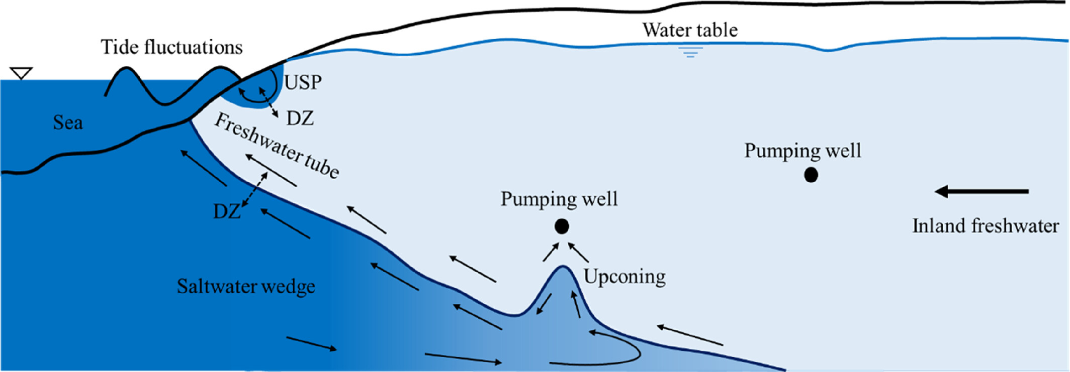
Schematic diagram of an unconfined coastal aquifer affected by tides and groundwater pumping. USP represents the upper saline plume, and DZ the diffusion zone.
Using 3H as a tracer to study streamflow components in large plain catchments on temperate climate
- First Published: 27 August 2024
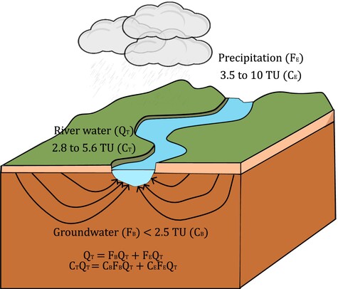
Tritium is a powerful tool for hydrograph separation. Significant differences in tritium contents exist between precipitation and groundwater.
Evolution of evapotranspiration in the context of land cover/climate change in the Han River catchment of China
- First Published: 27 August 2024
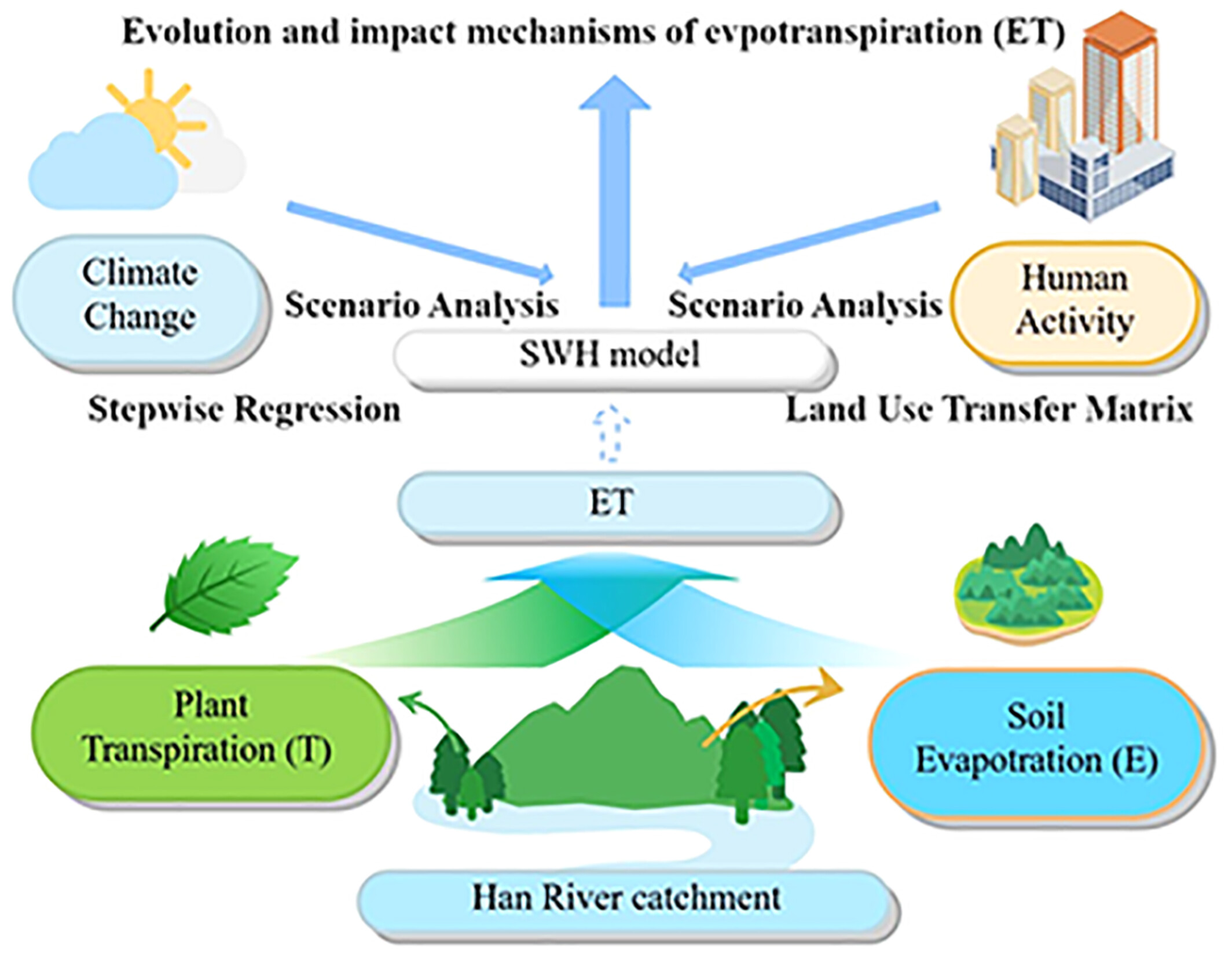
This study used the SWH model to simulate evapotranspiration and its components in the Han River catchment, China. Building upon well verification results, we investigated the temporal and spatial variation characteristics as well as the underlying mechanisms influencing evapotranspiration and its components in the Han River catchment. This study aims to provide a theoretical reference for understanding the response mechanism of evapotranspiration and optimizing water resource allocation in the catchment in the context of climate change and land use change.
Separating the impact of climate change and human activities on the connection between meteorological and hydrological drought
- First Published: 21 August 2024

The comprehensive influence of direct human activities and climate change on drought propagation is poorly understood. In this study, we constructed hydrological regeneration scenarios based on the soil and water assessment tool (SWAT) model to quantify the artificial and environmental forcing on the propagation from meteorological to hydrological drought. Results show that the dominant forcing on the propagation from meteorological to hydrological drought has a clear spatial divergence.
The changing characteristics of propagation time from meteorological drought to hydrological drought in a semi-arid river basin in India
- First Published: 28 August 2024
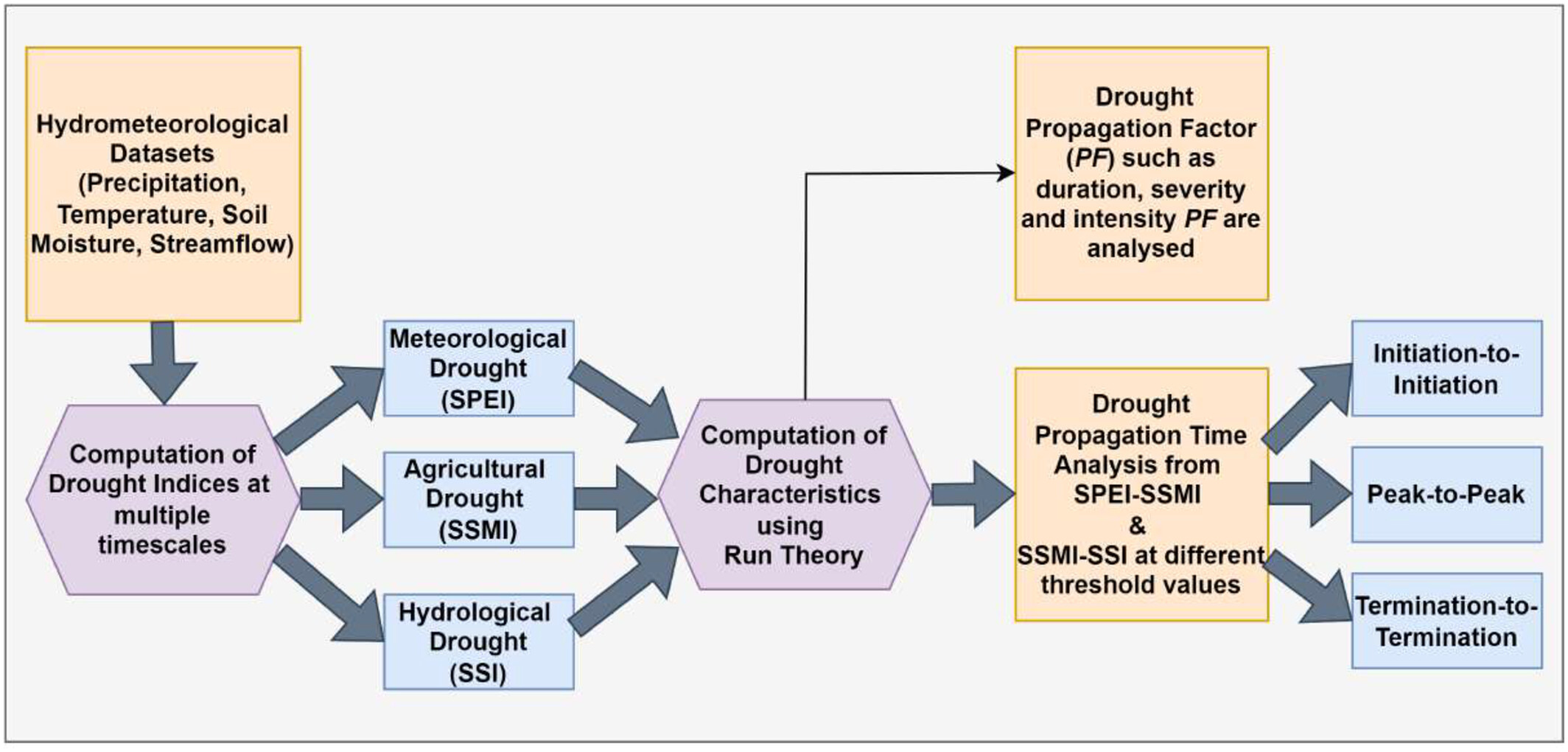
The drought propagation time from meteorological-to-agricultural (SPEI-to-SSMI) drought decreased for most of the tributaries of Krishna River Basin using multiple timescales at different threshold values, whereas it increased significantly for agricultural-to-hydrological (SSMI-to-SSI) drought. The duration propagation factor (PF) shrinks across all tributaries using multiple timescales at different threshold values for meteorological-to-agricultural drought, whereas it expands for agricultural-to-hydrological drought. On the other hand, the severity and intensity PF magnify for meteorological-to-agricultural drought, whereas it experiences dampening effects for agricultural-to-hydrological drought.
Assessment of dynamic hydrological drought risk from a non-stationary perspective
- First Published: 27 August 2024
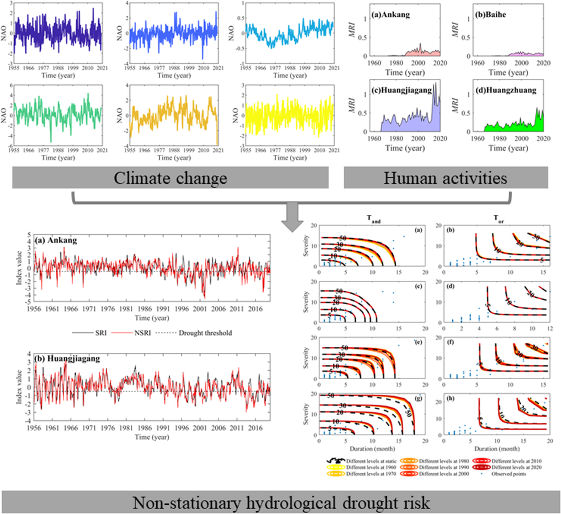
The NSRI constructed using a log-normal function with non-linear changes in location parameters with CI and MRI, as well as scale parameters with non-linear variation in CI, had better ability to characterize extreme runoff values than the conventional SRI. For multivariate risk assessment of hydrological drought, it is necessary to consider the non-stationarity in the dependence structure of variables. The hydrological drought risk in the HRB has increased in recent decades.
Characterizing hydro-geotechnical processes of slopes implemented with bioretention cells
- First Published: 27 August 2024
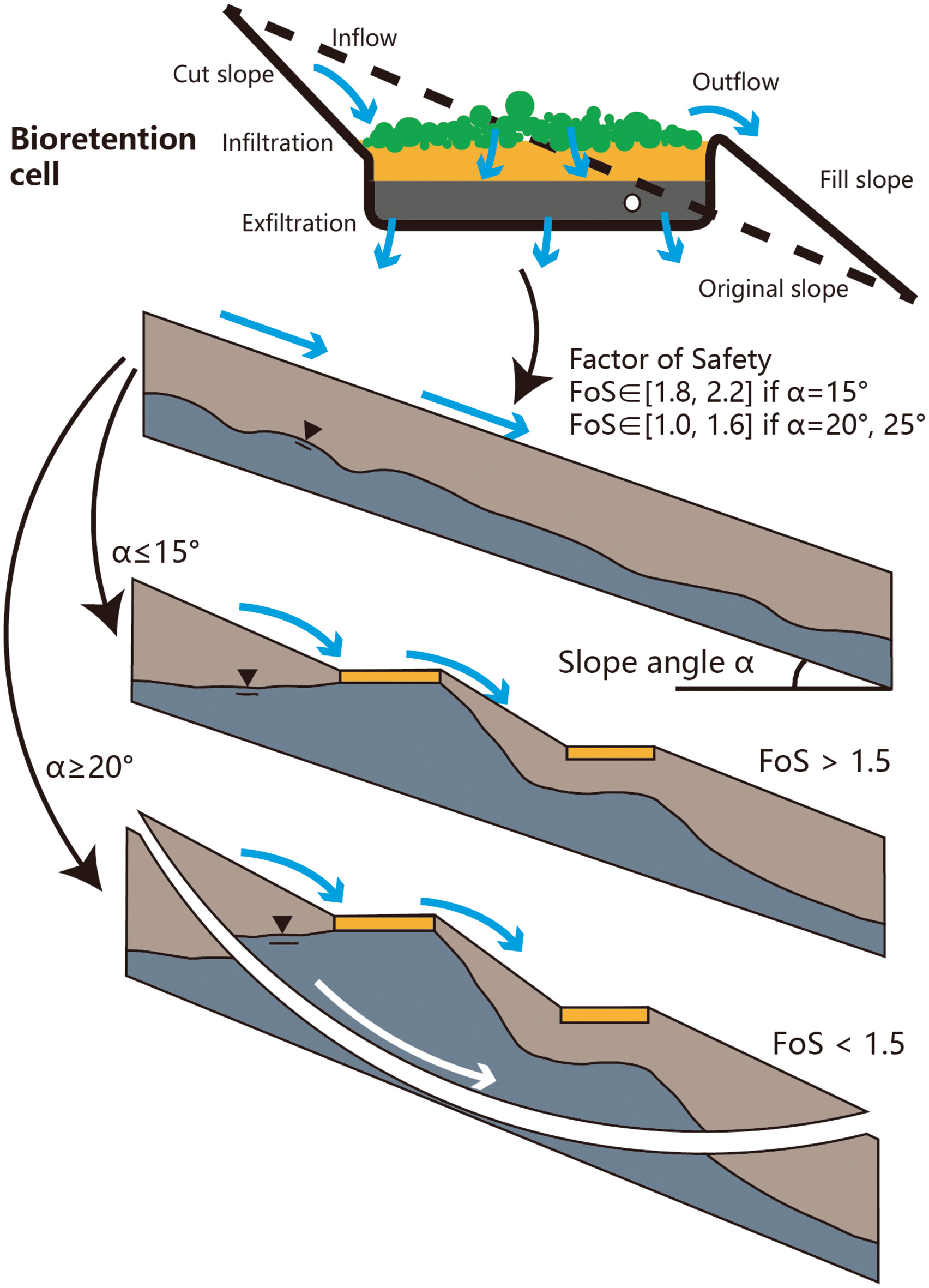
A numerical model was used to study the hydro-geotechnical processes of slopes with bioretention cells (BCs). It was found that slope cut/fill actions for BC implementation slightly enhanced stability. Groundwater mounds were observed to decrease stability, yet their dissipation did not significantly affect it. Slopes at a 15° angle generally remained stable when equipped with BCs.
RETRACTION
Retraction: Identifying baseflow source areas using remotely sensed and ground-based hydrologic data
- First Published: 27 August 2024
Sign up for email alerts
Tools
More from this journal
- Aims and Scope
- Collections/ Special Issues
- Call for Papers: Laboratory and field experiments on soil and rainfall characteristics for studying water erosion processes
- Call for Papers: Drought dynamics and vulnerability
- Pluvial Flooding: Maturing process understanding from data scarcity into data abundance
- Call for Papers: Hydrological processes in lowlands and plains
- Call for Papers: Preferential flow and eco-hydrological processes in the vadose zone
- MG Anderson Awards
- Top Cited Awards
- CHINA Collection
- SEO Guidelines for Authors
HP's Award Winning Articles
We're delighted to announce our 2024 prize winners!
MG Anderson Award
Forest cover lessens hurricane impacts on peak streamflow
Jazlynn Hall, Martha Scholl, James Shanley, Serena Matt, María Uriarte
Top Cited Paper
On strictly enforced mass conservation constraints for modelling the Rainfall-Runoff process
Jonathan M. Frame, Frederik Kratzert, Hoshin V. Gupta, Paul Ullrich, Grey S. Nearing
Top Cited Invited Commentary
Benchmarking hydrological models for an uncertain future
Keith Beven