

Journal list menu

 Issue
IssueHydrological Processes: Volume 35, Issue 2
February 2021
Export Citations
Download PDFs
ISSUE INFORMATION
WOMEN ADVANCING RESEARCH IN HYDROLOGICAL PROCESSES
Relating land surface, water table, and weathering fronts with a conceptual valve model for headwater catchments
- First Published: 15 December 2020
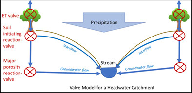
The subsurface is often treated as a black box in hydrologic models. But we are beginning to understand interactions among the land surface, weathering fronts, and the water table that push landscapes toward steady-state morphologies. Weathering fronts that change the porosity act like valves that partition water into shallow- and deep-flowing fractions. These flows then allow fronts for low- and high-solubility minerals, respectively, to advance at the erosion rate. This conceptualization could help to replace the black box when modelling headwater catchments.
Phosphorus retention in constructed wetlands enhanced by zeolite- and clinopyroxene-dominated lava sand
- First Published: 09 January 2021
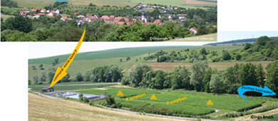
Constructed wetlands are frequently used in Germany for communal waste water purification including removal of phosphorus. The investigated filter sands (fluviatile as well as zeolite and clinopyroxene containing lava sands) were mainly accumulating inorganic, poorly crystalline P species, indicating no imminent threat of P saturation. A potentially high desorption capacity points to possible future recycling endeavours or use as soil amendments which needs further research.
RESEARCH AND OBSERVATORY CATCHMENTS: THE LEGACY AND THE FUTURES
Long term high frequency sediment observatory in an alpine catchment: The Arc-Isère rivers, France
- First Published: 11 January 2021
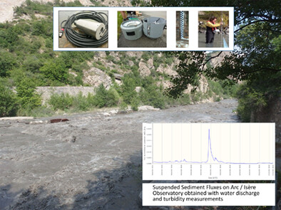
Suspended Sediment Fluxes on Arc / Isère Observatory obtained with water discharge and turbidity measurements.
An overview of hydrometeorological datasets from a small agricultural catchment (Nučice) in the Czech Republic
- First Published: 09 January 2021
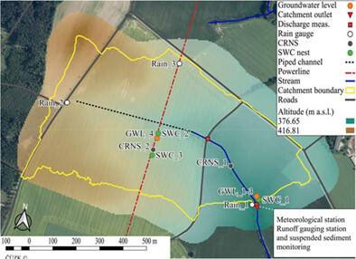
We introduce the freely available web-based Water in an Agricultural Landscape—NUčice Database (WALNUD) dataset at experimental catchment Nučice, the Czech Republic. The datasets consist of observed variables (e.g. measured precipitation, air temperature, stream discharge, and soil moisture) and are available online for public use. The cross-seasonal, open access datasets at this small-scale agricultural catchment will benefit not only hydrologists but also local farmers.
RESEARCH AND OBSERVATORY CATCHMENTS: THE LEGACY AND THE FUTURE
Long-term research catchments to investigate shrub encroachment in the Sonoran and Chihuahuan deserts: Santa Rita and Jornada experimental ranges
- First Published: 02 January 2021
The Baker Creek Research Watershed: Streamflow data highlighting the behaviour of an intermittent Canadian Shield stream through a wet–dry–wet cycle
- First Published: 09 January 2021
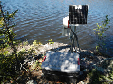
Streamflow is gauged in several sub-catchments of the Baker Creek Research Catchment. The period of record (2003-2019) includes both historic wet and dry periods. These data are helping to improve understanding of hydrological connectivity response to climate cycles in this discontinuous permafrost region dominated by exposed bedrock and lakes.
RESEARCH AND OBSERVATORY CATCHMENTS: THE LEGACY AND THE FUTURE
Long-term database of Beasley Lake Watershed with 25 years of agricultural conservation practices
- First Published: 25 January 2021
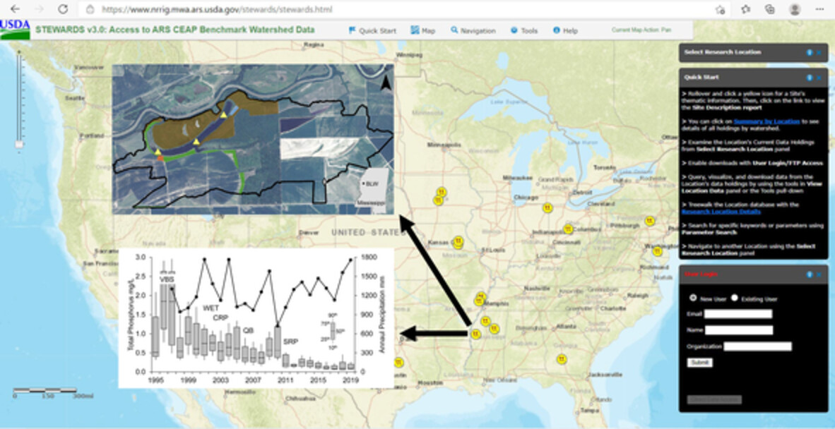
Informative: Beasley Lake Watershed, influenced by row-crop agriculture, is part of the USDA Conservation Effects Assessment Project (CEAP). The watershed has an archived 25-year long-term database that includes lake hydrology, precipitation, and water quality. The long-term database is available to researchers using a GIS-platform web-based application, Sustaining the Earth's Watersheds, Agricultural Research Data System (STEWARDS) that encompasses spatial and temporal data collected from multiple sites within the watershed.
ENVIRONMENTAL FLOW MECHANISM AND MANAGEMENT FOR RIVER-LAKE-MARSH SYSTEMS
Sustaining environmental flows in water-deficient rivers via inter-basin hydropower transfer
- First Published: 30 December 2020
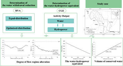
- The water-hydropower equivalent decreased as the transferred hydropower into the Luanhe River Basin increased;
- A transferred hydropower amount of 22.46 kWh/s, equivalent to 18.30 m3/s conserved water, was optimal for the Luanhe River Basin;
- The conserved water should be distributed to the Luanhe River in the proportions of 0.55:0.1:0.35 during the wet, normal and dry seasons, respectively, which is the optimal scheme to sustain the hydrological processes of the river.
A TRIBUTE TO EDWARD P. GLENN (1947-2017): A LEGACY OF SCIENTIFIC ENVIRONMENTAL ASSESSMENT AND APPLICATIONS IN HYDROLOGICAL PROCESSES
The role of hydrological processes in ecosystem conservation: Comprehensive water management for a wetland in an arid climate
- First Published: 17 December 2020
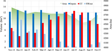
The water and mass balance of the Ciénega de Santa Clara, the most important remnant wetland of the Colorado River Delta, was analysed during 2014–2015. We examined different scenarios of future conditions based on variations of inflow from its principal binational source and the effects of the increase of temperatures in the watershed due to climate change. Maintenance of the Ciénega de Santa Clara's hydrological equilibrium will require at least 5.10 m3 s−1 of water during the summer months.
RESEARCH ARTICLES
Groundwater depletion in northern India: Impacts of the sub-regional anthropogenic land-use, socio-politics and changing climate
- First Published: 09 December 2020
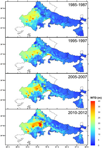
The changing spatial distribution of the three-year averaged groundwater level (WTD, meter below ground level) during the mid-decade years of the 1980s, 1990s, 2000s, and their comparison with that during 2010–2012.
Beaver dams attenuate flow: A multi-site study
- First Published: 21 December 2020
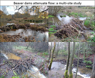
- Four sites were monitored where beavers have been reintroduced in Great Britain to understand the impacts of beaver dams upon flow attenuation.
- Analysis of >1000 storm events showed an overall trend of reduced total stormflow, increased peak rainfall to peak flow lag times and reduced peak flows.
- Analysis showed flow attenuation impacts due to beaver damming to persist during largest flood events, whilst additionally flow regimes became overall less flashy following beaver impact.
Growing season evapotranspiration in boreal fens in the Athabasca Oil Sands Region: Variability and environmental controls
- First Published: 23 December 2020
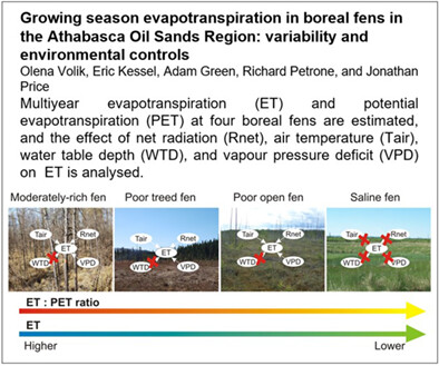
Multiyear evapotranspiration (ET) and potential evapotranspiration (PET) at four boreal fens are estimated, and the effect of net radiation (Rnet), air temperature (Tair), water table depth (WTD), and vapour pressure deficit (VPD) on ET is analyzed.
Observations of canopy storage capacity and wet canopy evaporation in a humid boreal forest
- First Published: 23 December 2020
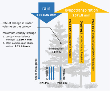
- Measurements of canopy water balance components are performed in a humid balsam fir boreal forest during the snow-free seasons of 2017 and 2018.
- The rate of change in water volume on the canopy was estimated with water balance and directly measured using stem compression system.
- Evapotranspiration partitioning was estimated with eddy-covariance and sapflow measurements.
Effect of leaf distribution pattern on the interception storage capacity of leaf litter under simulated rainfall conditions
- First Published: 23 December 2020
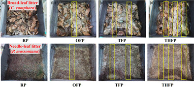
Leaf shape and slope have a great impact on the leaf litter interception. The minimum ISC (Cmin) of the leaf litter at flat and gentle slopes exceeds that at steep slope. Leaf distribution pattern has a major effect on the leaf litter interception. Flow paths increase the litter drainage and reduce the interception capacity. The maximum ISC (Cmax) of the leaf litter decreases with increasing number of flow paths. Leaf distribution patterns in the litter layer. RP, OFP, TFP and THFP represent the random pattern, one flow path, two flow paths and three flow paths, respectively.
A meteorological-based crop coefficient model for estimation of daily evapotranspiration
- First Published: 30 December 2020

A formula for quick estimation of actual evapotranspiration of any crops is suggested. The crop coefiicient is introduced as a function of reference evapotranspiration and relative humidity.
Impact of evaporation on field capacity during water drainage redistribution in a soil
- First Published: 30 December 2020
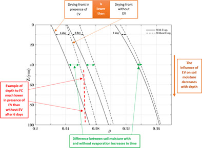
Evaporation (EV) plays an important role in soil drainage. Our analysis showed that the stronger EV is the faster the water reaches deeper depths. Additionally, the smaller the hydraulic conductivity of a soil is the stronger the impact of EV on the drainage of a soil.
Seasonal connections between meteoric water and streamflow generation along a mountain headwater stream
- First Published: 02 January 2021
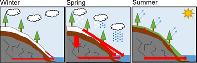
Assessments of seasonal stable water isotope trends in a mountain watershed indicate increased connectivity between areas proximal to streams and streamflow during the winter period. The use of a longitudinal sampling scheme provided a mechanism for relating changes in elevation with hillslope-stream connectivity, taking advantage of the isotopic lapse rate of precipitation. Correlations between elevation and δD are strongest during February and March, and weak during July and August, indicating increased transmission of meteoric water during winter and spring, and decreased later in the year.
Effects of riverbed incision on the hydrology of the Vietnamese Mekong Delta
- First Published: 02 January 2021
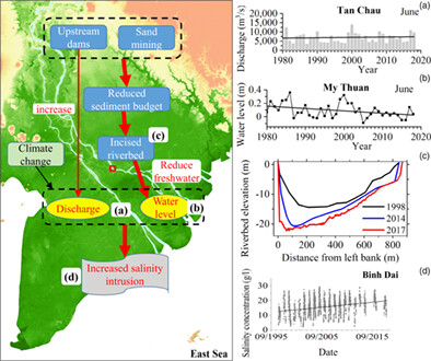
The hydrogeomorphology of the Vietnamese Mekong Delta has been significantly altered by natural and anthropogenic drivers. By analysing the long-term discharge, water level, sediment, and bathymetric data, supported by a coupled 2D hydro-sediment-morpho dynamics model, we observed that riverbed incision was the main cause of the decreased dry season water levels in the Tien River, although the respective discharges increased. Consequently, the decreased water level was likely one of the main causes of the enhanced salinity intrusion.
Major ion chemistry of two cratonic rivers in the tropics: Weathering rates and their controlling factors
- First Published: 06 January 2021
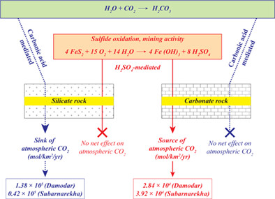
Dissolved major ion chemistry of two tropical rivers (Damodar and Subarnarekha) from India has been investigated to constrain solute sources and weathering patterns. High TDS and sulphate concentrations of these rivers are due to intense sulphide oxidation in the mining-dominated regions. The area-normalized sulphide oxidation fluxes in these streams are higher compared to that for global rivers. Chemical weathering in tropical rivers influenced by sulphuric acid, therefore, may release a significant amount of CO2 into the atmosphere.
Analytical investigation of the exact groundwater divide between rivers beyond the Dupuit–Forchheimer approximation
- First Published: 06 January 2021
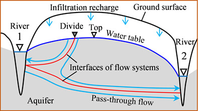
- The exact groundwater divide on the water table is delineated as the division point of two local flow systems transporting infiltration water toward two rivers.
- The top of the water table is not the exact groundwater divide and the distance between them can reach up to 8.9% of the distance between rivers.
- The analytical method is applied to the Loess Plateau, China.
Nitrate removal processes in the riverbed during a single-peak flood event
- First Published: 09 January 2021
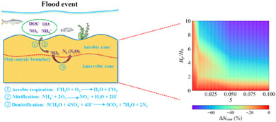
The model of nitrogen cycling in the hyporheic zone (HZ) with unsteady flow effects was proposed. An optimal range of river channel gradients for enhancing biogeochemical reactions was found. The nitrate sink-source function transformations of HZ were independent of the flood events. The nitrate removal efficiency during a single-peak flood event was quantified.
An experimental investigation of the effects of thawed soil depth on rill flow velocity
- First Published: 12 January 2021
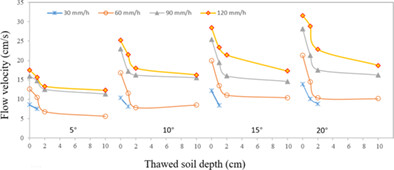
Rill flow velocity decreases with increasing thawed soil depth, and the decreasing rate also decreased. Rill flow velocity responds differently to slope gradient and rainfall intensity under different thawed depths. Model was established to estimate rill flow velocity on partially thawed soil slopes.
Choosing an arbitrary calibration period for hydrologic models: How much does it influence water balance simulations?
- First Published: 13 January 2021
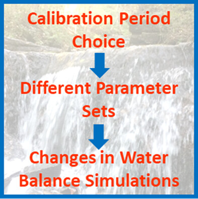
We investigated how much the choice of calibration period can affect water balances in Soil and Water Assessment Tool models of three United States watersheds. We found that this choice can cause substantial changes in snowmelt, evapotranspiration, surface runoff, soil water, and groundwater flow simulations. Thus, any study that is relying on these unmeasured components (e.g., water quality, climate change impacts, and best management practice studies) should choose calibration periods selectively and carefully.
Acceleration of vegetation dynamics in hydrologically connected wetlands caused by dam operation
- First Published: 30 December 2020
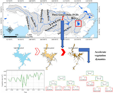
- Drawdown processes of Poyang Lake level during dry season were quickened post the operation of Three Gorges Dam (TGD).
- Antecedent near-term water level fluctuations exerted strong influences on vegetation coverage.
- Quickened drawdown processes of Poyang Lake accelerated vegetation expansion.
RESEARCH AND OBSERVATORY CATCHMENTS: THE LEGACY AND THE FUTURES
Sources and biodegradability of dissolved organic matter in two headwater peatland catchments at the Marcell Experimental Forest, northern Minnesota, USA
- First Published: 17 January 2021
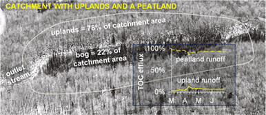
Catchment characteristics and sources of stream water affect DOM biodegradability and downstream transport. TOC concentrations and DOM biodegradation rates were highest during low flow when water and DOM mostly originated from bogs and uplands were disconnected from streams. Peatlands, even if only partial areas of catchments, override effects of uplands on the concentrations and biodegradability stream of DOM.
ENVIRONMENTAL FLOW MECHANISM AND MANAGEMENT FOR RIVER-LAKE-MARSH SYSTEMS
Quantifying suitable dynamic water levels in marsh wetlands based on hydrodynamic modelling
- First Published: 20 January 2021
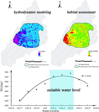
- A two-dimensional hydrodynamic model (MIKE 21) was established to simulate the hydrological process in the marsh wetland.
- The dynamic suitable water levels in Zhalong Wetland was obtained.
- The optimized schemes about the water diversion amount and timing were proposed to improve the compliance rate of the suitable water levels.
RESEARCH ARTICLES
Urban stream temperature patterns: Spatial and temporal heterogeneity in the Philadelphia region, Pennsylvania, USA
- First Published: 09 January 2021
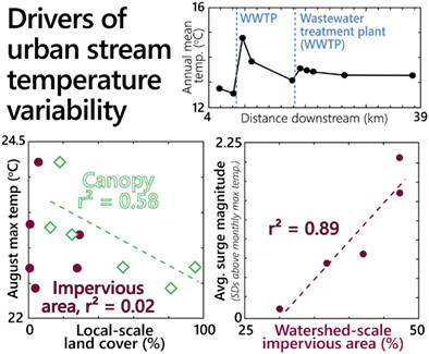
Many factors drive urban stream temperature heterogeneity. In this study, wastewater treatment plants were the strongest driver of downstream temperature changes; treatment plants that discharged into larger streams, had cooler effluent, or had lower discharge had less impact. Urban headwater sites with more local riparian canopy had cooler maximum temperatures, while watershed-scale impervious area was associated with greater surge frequency and magnitude during some storms. Restoring riparian canopy in urban settings may impact stream temperatures more than treating impervious area.
Seasonal and short-term controls of riparian oxygen dynamics and the implications for redox processes
- First Published: 20 January 2021
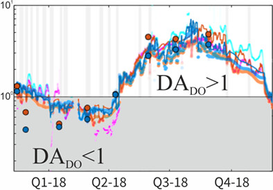
Groundwater tracer-tests are combined with 1-year high-frequency data of dissolved oxygen, water temperature, and water-levels, and data-driven simulations to assess the seasonal and event-term variations of transport and consumption of riparian dissolved oxygen and the further implications for redox processes.
Quantitative effects of changes in agricultural irrigation on potential evaporation
- First Published: 22 January 2021
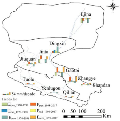
Distribution of trend slopes per decade of Epen, Erad, and Eaero in the different stations in the HRB (1970–2017).
- Under the influence of irrigation, the annual variation of Epen in the agricultural, natural, and desert areas was significantly different.
- From 1970 to 1998, the annual trend slope of Epen in the agricultural area significantly decreased by 39 mm decade−1. After the implementation of water-saving irrigation, the Epen in the agricultural areas increased by 54 mm decade−1 from 1998 to 2017.
- The main meteorological factors influencing the variation of Epen in HRB are U2 and VPD.
Estimation of mass and energy balance of glaciers using a distributed energy balance model over the Chandra river basin (Western Himalaya)
- First Published: 21 January 2021
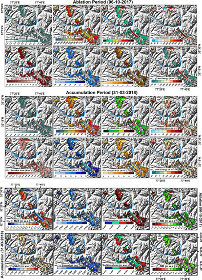
- Modelling of glacier-wide air temperature, energy and mass fluxes.
- Development of two-dimensional satellite based energy and mass balance model.
- Validation of the proposed model with AWS data and sensitivity analysis.
Local meteoric water lines describe extratropical precipitation
- First Published: 25 January 2021
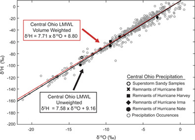
Precipitation samples (n=498) were collected in three locations in central Ohio during 2012–2018. Precipitation samples from Columbus, Galena and Mansfield, Ohio are plotted with a precipitation volume weighted local meteoric water line (LMWL) and an unweighted LMWL to describe the data. Extratropical precipitation (hurricane remnant) samples collected as part of this study are plotted with precipitation occurrences. The extratropical precipitation samples fall along LMWLs, showing that the δ2H–δ18O relationship of extratropical precipitation is consistent with all precipitation occurrences.
Response of soil aggregate disintegration to the different content of organic carbon and its fractions during splash erosion
- First Published: 25 January 2021
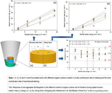
Soil aggregate stability increased with the increases of soil organic carbon and light fraction organic carbon. Macroaggregates (>0.25mm) in eroded soil increased with the increase of organic carbon. Increase of heavy fraction organic carbon reduced the slaking effects on aggregates disintegration during splash erosion.
Typhoon rainfall impact on drip water δ18O in Xianyun cave, Southeast China
- First Published: 25 January 2021
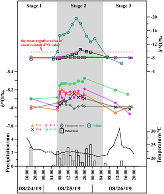
During Typhoon Bailu, the δ18O values of the instantaneous drip water samples exhibited similar characteristics, like the inverted U-shape of typhoon-induced rainfall, outside of the cave, but they had less negative deviation due to the low precipitation amount (approximately 28.8 mm) and larger drip water source reservoir.
Mean residence time of lagoons in shallow vegetated floodplains
- First Published: 29 January 2021
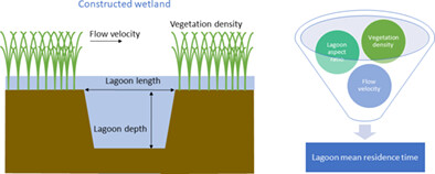
Lagoons interspersed in wetlands increase the mean residence time of the flow. The lagoon mean residence time increases as the lagoon depth increases. The lagoon length did not modify the mean residence time. The flow enters the lagoon through its leading edge and flows out through its trailing edge. Dense nearby lagoon vegetation decreases the lagoon mean residence time, i.e. producing short-circuiting and homogenizing the flow at the leading edge of the lagoon.
HPEYE
Time-lapse visualization of spatial and temporal patterns of stream network dynamics
- First Published: 23 February 2021
Sign up for email alerts
Tools
More from this journal
- Aims and Scope
- Collections/ Special Issues
- Call for Papers: Laboratory and field experiments on soil and rainfall characteristics for studying water erosion processes
- Call for Papers: Drought dynamics and vulnerability
- Pluvial Flooding: Maturing process understanding from data scarcity into data abundance
- Call for Papers: Hydrological processes in lowlands and plains
- Call for Papers: Preferential flow and eco-hydrological processes in the vadose zone
- MG Anderson Awards
- Top Cited Awards
- CHINA Collection
- SEO Guidelines for Authors
HP's Award Winning Articles
We're delighted to announce our 2024 prize winners!
MG Anderson Award
Forest cover lessens hurricane impacts on peak streamflow
Jazlynn Hall, Martha Scholl, James Shanley, Serena Matt, María Uriarte
Top Cited Paper
On strictly enforced mass conservation constraints for modelling the Rainfall-Runoff process
Jonathan M. Frame, Frederik Kratzert, Hoshin V. Gupta, Paul Ullrich, Grey S. Nearing
Top Cited Invited Commentary
Benchmarking hydrological models for an uncertain future
Keith Beven