

Journal list menu

 Issue
IssueRiver: Volume 3, Issue 1
i-iii, 1-117February 2024
Export Citations
Download PDFs
ISSUE INFORMATION
COMPREHENSIVE REVIEW
Opportunities and challenges of interdisciplinarity in river water environmental ethics and integrated river basin management
- Pages: 1-7
- First Published: 04 February 2024
RESEARCH ARTICLES
Development of a hazard risk map for assessing pedestrian risk in urban flash floods: A case study in Cúcuta, Colombia
- Pages: 8-23
- First Published: 14 March 2024

This study introduces a cutting-edge approach to assess pedestrian risk in urban flood scenarios, applied to Cúcuta, Colombia, using a calibrated hydrological model and image recognition algorithms. It reveals a notable increase in risk with extended return periods, emphasizing the need for dynamic safety measures in urban planning. The findings set a precedent for applying this methodology in similar urban settings to improve pedestrian safety during flood events.
Impacts of temporal/spatial rainfall heterogeneities on peak runoff distribution and intensities for an urban river basin of south China
- Pages: 24-37
- First Published: 27 February 2024
Short- and long-term legacies of carbon sequestration, and nutrient burial in floodplain wetlands of agricultural and forested catchments, Indiana, United States
- Pages: 38-46
- First Published: 11 March 2024
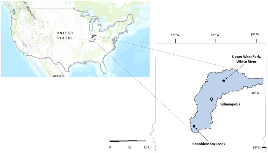
Short- and long-term legacies of carbon sequestration, and nutrient burial in floodplain wetlands of agricultural and forested catchments, Indiana, United States. Soil organic carbon (C) sequestration and nitrogen (N) and phosphorus (P) burial were measured in soils of two floodplain wetlands of the West Fork of the White River watershed (Indiana, USA) whose catchments differed in land use. These findings confirm previously published studies that show that P enrichment and accumulation in soils represent legacy effects of contemporary agricultural land use of the agricultural floodplain and historical tillage and plowing of the forested catchment.
Surface movement detection and stability evaluation of a loose fine-grained soil slope during reservoir operation: A case study in NE reservoir
- Pages: 47-58
- First Published: 13 March 2024
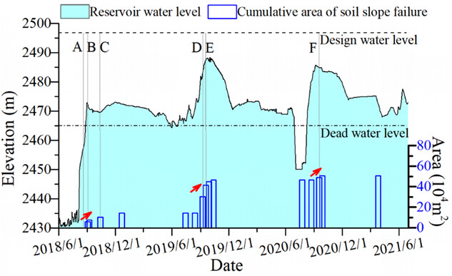
The surface movement characteristics before and after the occurrence of landslides in the NE reservoir in the region scale were detected and interpreted by Sentinel-2 time series images. Experimental studies were conducted to investigate the geotechnical properties of the fine-grained soil. The slope stability was evaluated for a typical slope profile considering the rising water level using the extended Bishop's simplified method, which was implemented in the code STAB-UNSAT.
Prediction of the water level at the Kien Giang River based on regression techniques
- Pages: 59-68
- First Published: 18 January 2024
Flow and sediment measurement for the Three Gorges Project
- Pages: 69-77
- First Published: 20 February 2024
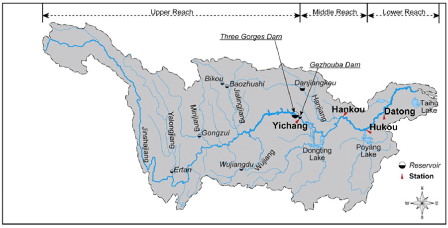
The flow and sediment measurement of the Three Gorges Project (TGP) is mainly introduced in this paper. It includes the general situation of the TGP, the distribution of the hydrological network, the measurement factors, the new measurement technology, and the sediment changes in the reservoir and downstream after the impoundment of the TGP.
Quantification of sediments and delineation of their sources in Nyabugogo Stream, RWANDA: Relationship with economic development activities
- Pages: 78-88
- First Published: 18 February 2024
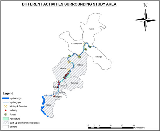
The main sources of sediments are delineated, while corresponding loads are also quantified. After the analysis of those sediments in different periods, the relationship between economic development activities and sediment loads in Nyabugogo Stream were also determined.
Exploring the past to discern the present: The role of historico-geographical study in differentiating natural river channels from artificial canals
- Pages: 89-106
- First Published: 19 January 2024
A real-time flood forecasting hybrid machine learning hydrological model for Krong H'nang hydropower reservoir
- Pages: 107-117
- First Published: 28 January 2024
Sign up for email alerts
Tools
Published on behalf of the China Institute of Water Resources and Hydropower Research (IWHR)

More from this journal

Understanding open access
As an open access journal, all articles in River will be freely available to read, download and share immediately upon publication. Learn more about open access:
Latest activities
