

Journal list menu

Export Citations
Download PDFs
Table of Contents
Integrating sediment connectivity and stream power index with RUSLE for modelling soil erosion dynamics in a large Himalayan basin under modern and future climate scenarios
- First Published: 06 March 2025
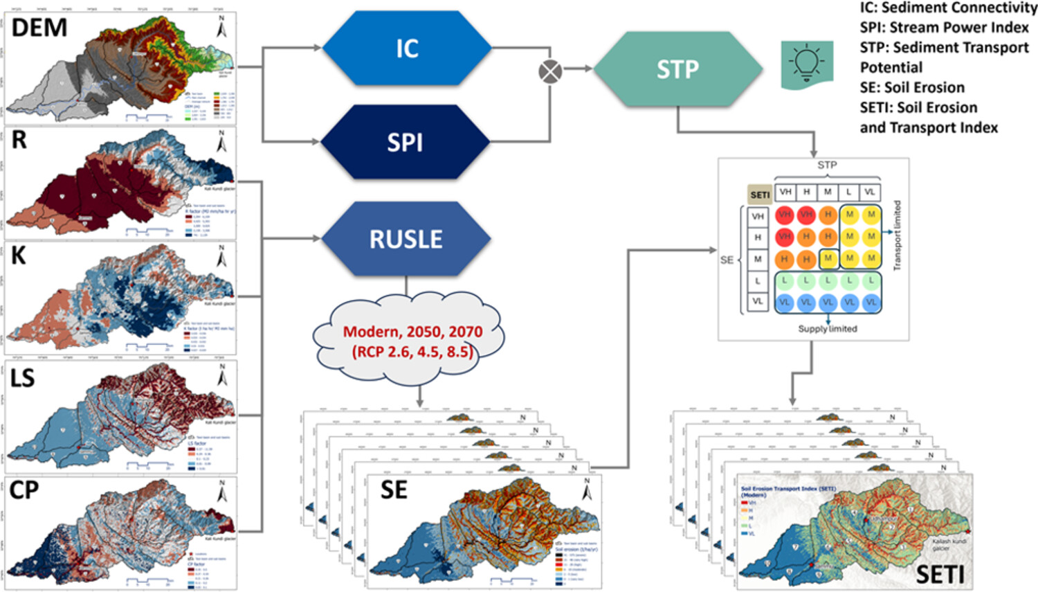
This manuscript presents an innovative coupled modelling framework for assessing erosion dynamics in a large Himalayan basin. We have integrated the RUSLE-based soil erosion modelling with sediment connectivity and stream power index to compute soil erosion and transport index (SETI) under modern and future climate scenarios.
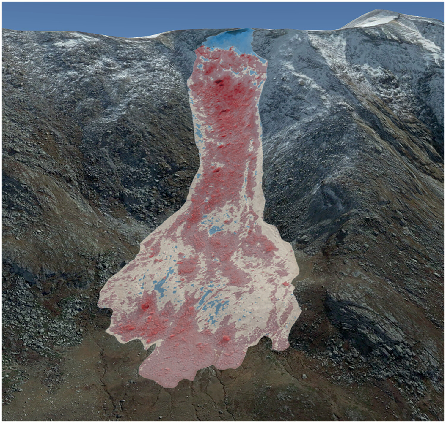
Geomorphological processes and landforms in the Alpine Sulzenau Valley (Tyrol, Austria): Glacier retreat, glacial lake evolution and the 2017 glacial lake outburst flood
- First Published: 09 October 2024
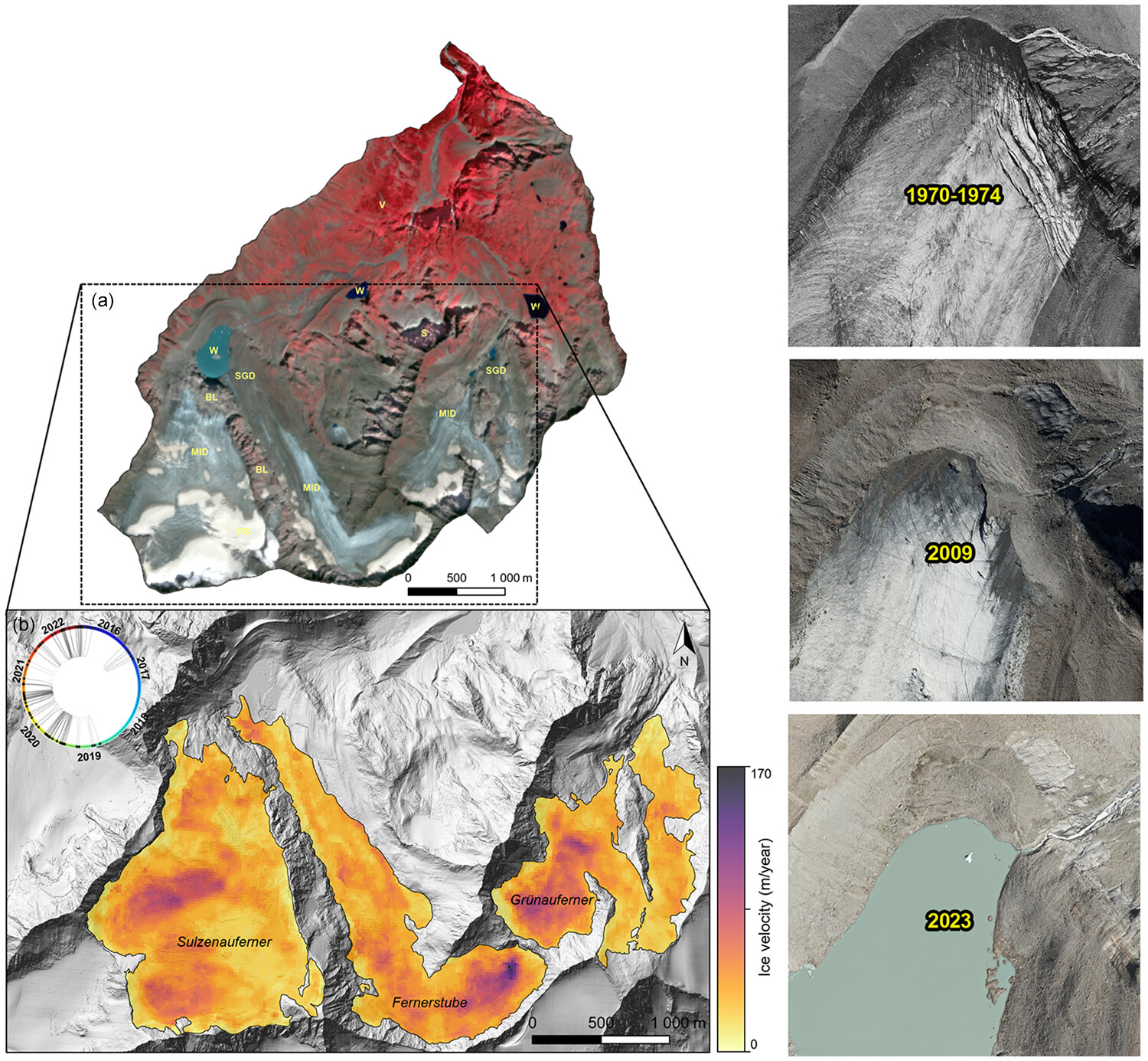
This study investigates Lake Sulzenau in Tyrol, Austria, focusing on the glacial lake outburst flood (GLOF) that occurred in 2017. By employing multi-source remote sensing data and geomorphological analysis, the research reveals that the GLOF was likely triggered by a dam failure resulting from increased meltwater and precipitation, alongside ongoing glacier retreat, highlighting the intricate environmental changes and hazards in Alpine regions under the influence of global warming.
Multiscale characterization of splays produced by a historic, rain-on-snow flood on a large braided stream (Platte River, Central USA)
- First Published: 26 September 2024
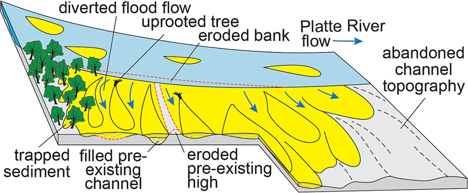
A historical flood generated 32 splays covering 1,438 ha along a 122 km reach of the braided lower Platte River. 94% of the splays were bank-top splays deposited on abandoned braid channels presently cultivated for row crops. Splays pose an increasing hazard as rain-on-snow floods are becoming more common in the central USA.
Anthropogenic effects on flood hazards in a hyper-arid watershed: The 2015 Atacama floods
- First Published: 14 November 2024
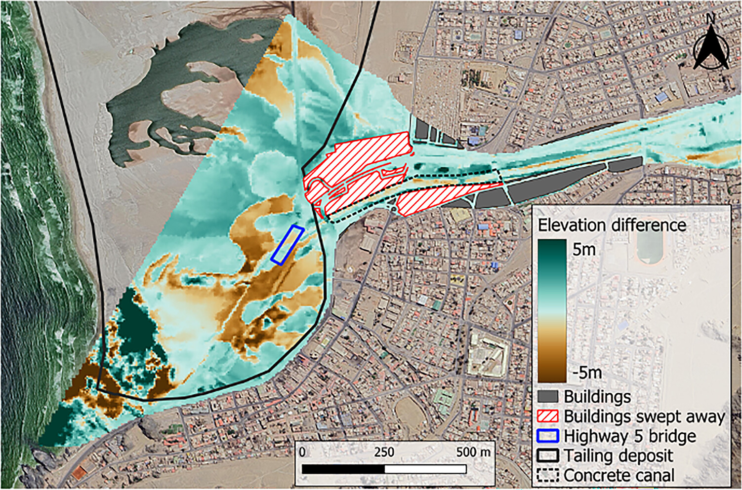
Difference of the flood propagation after the topographic changes shows the anthropic amplification of the exposure and hazards.
Trench investigation to quantify debris flow activity for landslide hazard mapping in populated areas: Lessons learned from Gol, southern Norway
- First Published: 15 November 2024
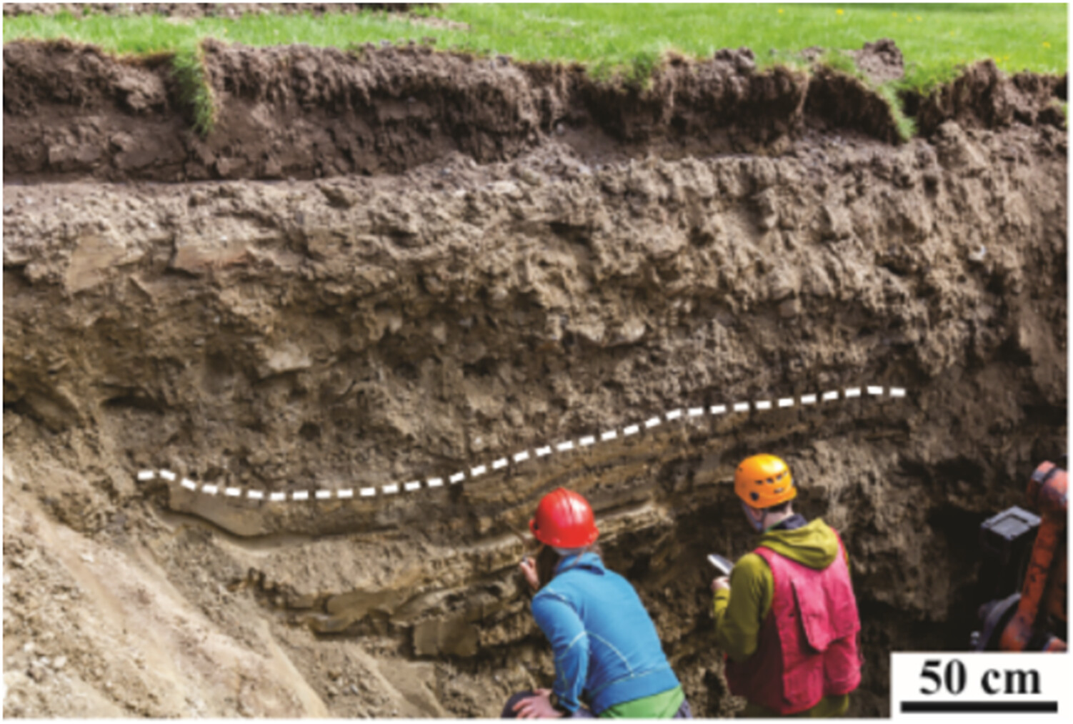
The sedimentology and stratigraphy of postglacial debris flow beds found in a densely populated area are described and shows mass-wasting activity throughout the Holocene, also within the last 1000 years. This is important knowledge to aid in the interpretation of the Quaternary history of the area and to determine hazard zones.
Evaluation of the impact of climate change on rainfall for potential landslide triggering in Japan
- First Published: 08 December 2024
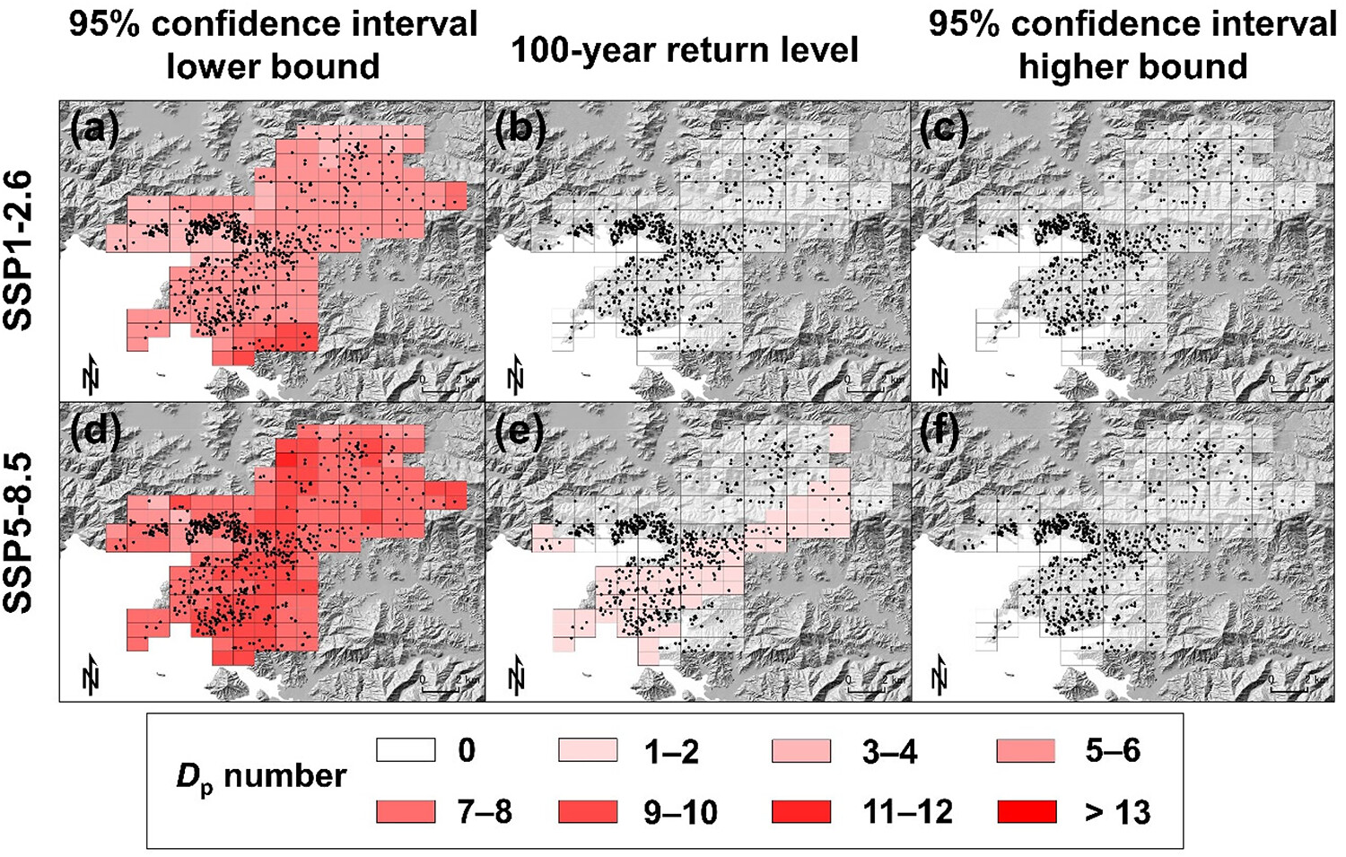
Under the scenario that future greenhouse gas emissions will continue to increase, the projection of precipitation in Japan until 2,100 suggests that intense rainfall with landslide-triggering potential might increase and occur synchronously in two to five regions owing to more frequent and widespread occurrence of precipitation.
Time-series ground surface deformation revealed by advanced land observing satellite-2 and Sentinel-1 along the Bei'an-Hei'he highway in Northeast China
- First Published: 27 January 2025
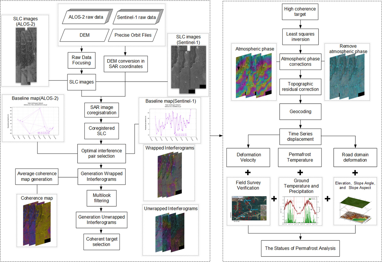
Obvious ground subsidence along the Bei'an-Hei'he Highway (BHH) in Northeast China was detected using ALOS-2 and Sentinel-1 data, revealing subsidence in areas with significant permafrost temperature variations, with deformation correlated to precipitation, temperature, elevation, slope angles and aspects.
The role of wildfires and forest harvesting on geohazards and channel instability during the November 2021 atmospheric river in southwestern British Columbia, Canada
- First Published: 29 January 2025
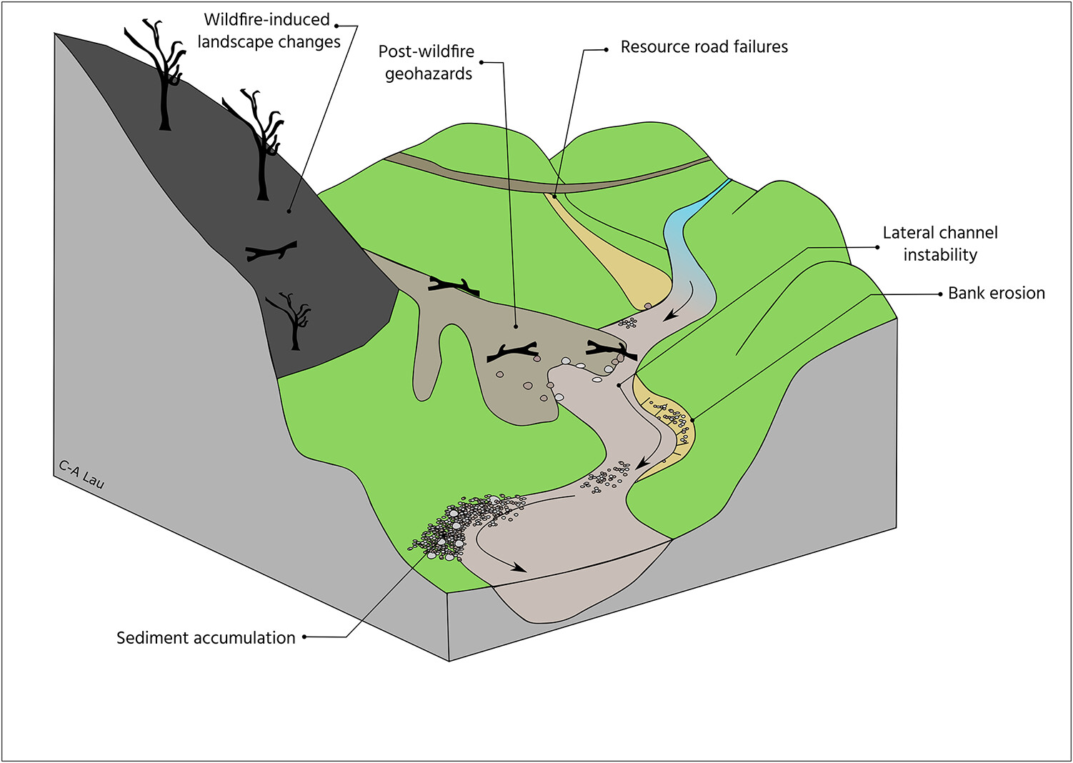
During the November 2021 atmospheric river in British Columbia, Canada, hundreds of landslides were triggered. We found that geohazards occurred more frequently in wildfire burned areas and along forest harvesting resource roads, providing point sources of sediment that entered mainstem rivers and caused river channels to shift.
Debris-flow entrainment modelling under climate change: Considering antecedent moisture conditions along the flow path
- First Published: 18 May 2024
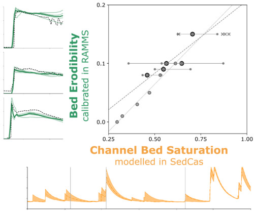
We developed a predictive modelling framework to estimate bed erodibility based on antecedent saturation of the channel bed. The modelled saturation conditions and the RAMMS-calibrated bed erodibility exhibit a strong correlation when debris flows adhere to typical flow patterns, making the proposed framework a promising tool for hazard assessments under climate change.
What controls river widening? Comparing large and extreme flood events
- First Published: 13 May 2024
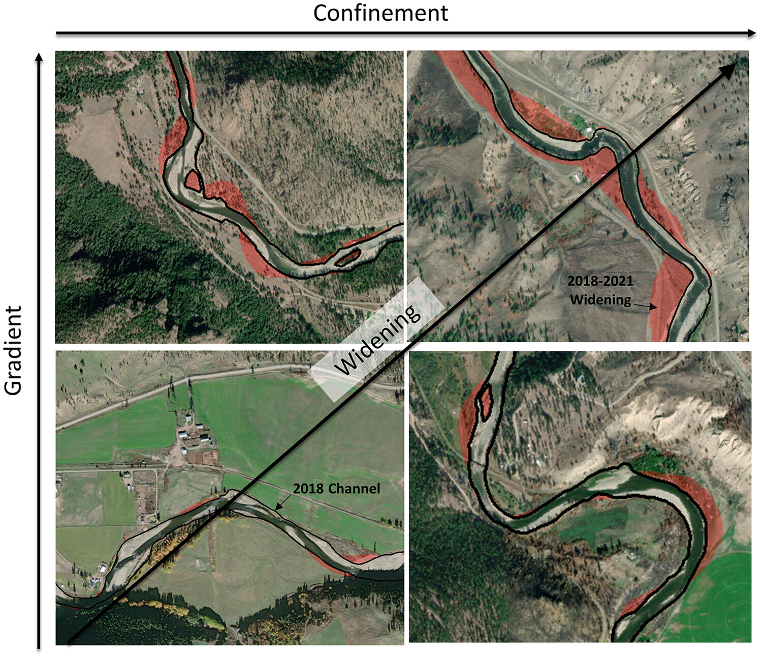
River erosion during extreme floods poses a threat to communities and infrastructure but can be difficult to model. This work shows that erosion during an extreme flood is related to the unit stream power and at the simplest level tends to increase with river gradient and confinement.
Predisposing, triggering and runout processes at a permafrost-affected rock avalanche site in the French Alps (Étache, June 2020)
- First Published: 16 May 2024
This paper investigates the triggering and propagation conditions of a recent rock avalanche (c. 225,000 m3, French Alps, 2020) at a permafrost site. Several methods including temperature monitoring, geophysical survey, energy balance and heat transfer modelling show a permafrost warming with a transition from cold to warm permafrost in the release area and significant water infiltration weeks and days prior to the event. Runout simulations point out the complexity of the propagation mechanism, involving several phases and different rheological properties.
Wildfire, extreme precipitation and debris flows, oh my! Channel response to compounding disturbances in a mountain stream in the Upper Colorado Basin, USA
- First Published: 18 July 2024
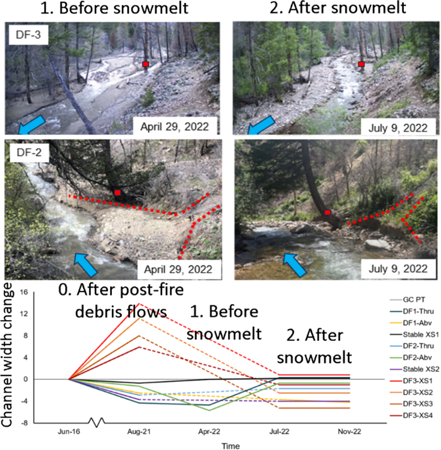
Repeat field surveys and lidar differencing reveal space- and time-varying channel changes following several large post-fire debris flows in a steep mountain stream in the western United States. Factors influencing local channel response included channel and valley width, unit stream power, large woody debris and snowmelt discharge.
An extreme wave event in Timanfaya National Park: Possible first geological evidence of the 1755 Lisbon tsunami in Lanzarote, Canary Islands
- First Published: 07 August 2024
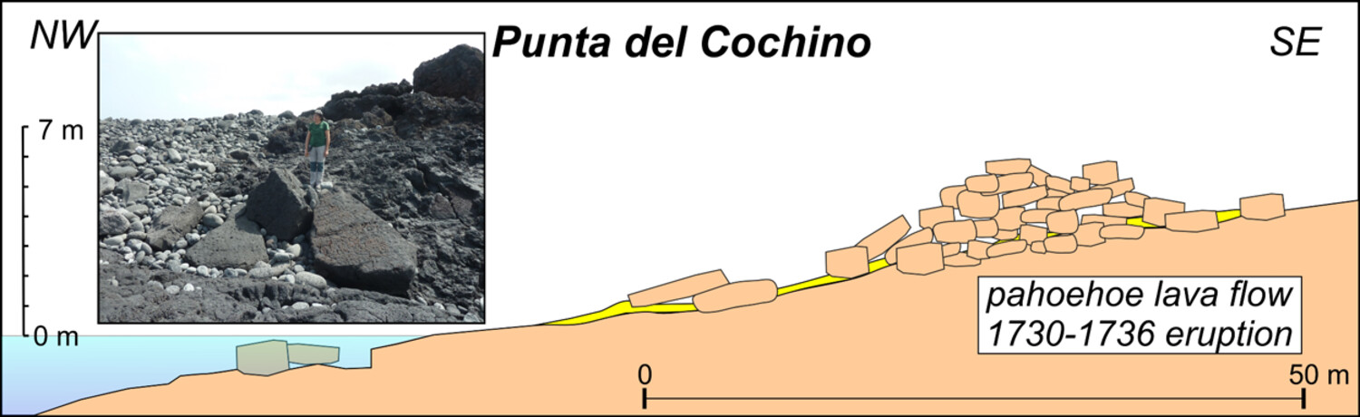
- Two extreme wave event deposits of boulders have been located on a coastal platform formed by lavas from the 1730-36 Timanfaya eruption in Lanzarote Island.
- The modelling of wave heights and tsunami heights required to mobilise these blocks shows that a tsunami was necessary to accumulate the boulders into ridges.
- This work confirms for the first time the geological record of the 1755 Lisbon tsunami on the Canary Islands, allowing a distinction between tsunami-associated deposits and those formed by large storms.
Inundation and flow properties of a runoff-generated debris flow following successive high-severity wildfires in northern Arizona, USA
- First Published: 16 October 2023
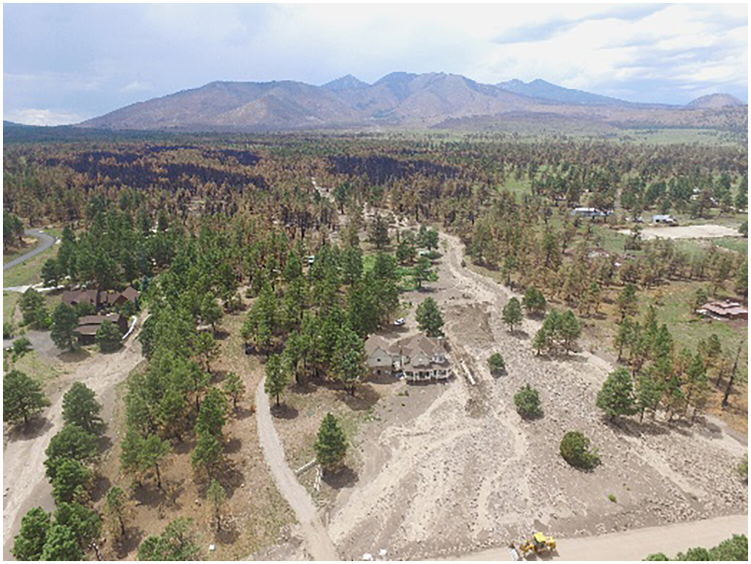
This study focuses on quantifying changes in the properties of a post-fire debris flow in Northern Arizona, USA, along a 7-km runout path. The flow transitioned from granular to muddy debris flow, leading to differences in deposit morphology and maximum clast size. The flow volume was 28 times greater than that of a debris flow in the same watershed following a severe wildfire 12 years prior, highlighting the importance of considering compound effects from successive high-severity fires.
The effect of location and geometric properties of landslides caused by rainstorms and earthquakes
- First Published: 11 March 2024
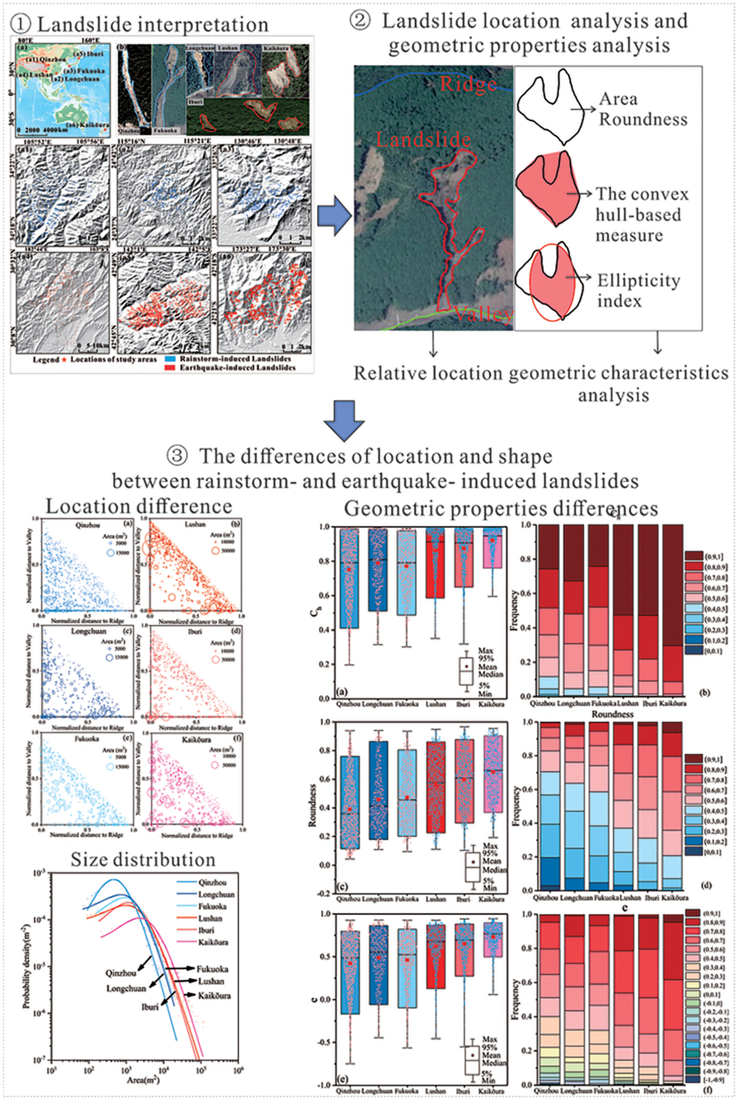
This study found that both location and geometric properties are specific to landslide type and differ between rainstorm- and earthquake-induced landslides. Compared with rainstorm-induced landslides, earthquake-induced landslides are more common near the ridge of a slope and have a larger, more compact, rounded and less complex shape.
Study on thermal-hydro-mechanical coupling and stability evolution of loess slope during freeze–thaw process
- First Published: 26 February 2024
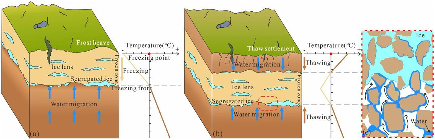
In the process of freezing and thawing, water migration occurs in the loess slope, resulting in the frozen stagnant water effect, which makes the water enriched in the slope. This makes the mechanical strength parameters of loess deteriorate. The effect of frost heave and thaw settlement destroys the soil structure and makes the soil particles rearrange. This threatens the stability of loess slope.
Observations and computational multi-phase modelling in tropical river settings show complex channel changes downstream from rainfall-triggered landslides
- First Published: 10 April 2024
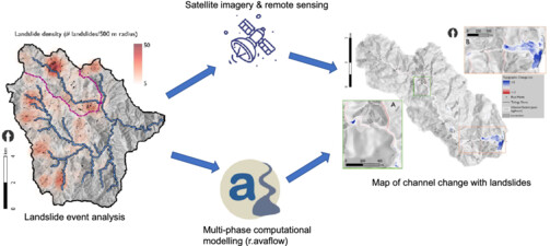
The Antamok River (Philippines) was affected by more than 500 landslides during Typhoon Mangkhut in September 2018. Landslide mapping using satellite imagery and remote sensing, together with multi-phase computational modelling, highlighted key areas of erosion and deposition in the catchment, which could not be represented by traditional approaches such as unit stream power threshold.
Mapping landscape evolution in 3D: Climate change, natural hazard and human settlements across the 1618 Piuro landslide in the Italian Central Alps
- First Published: 30 November 2023
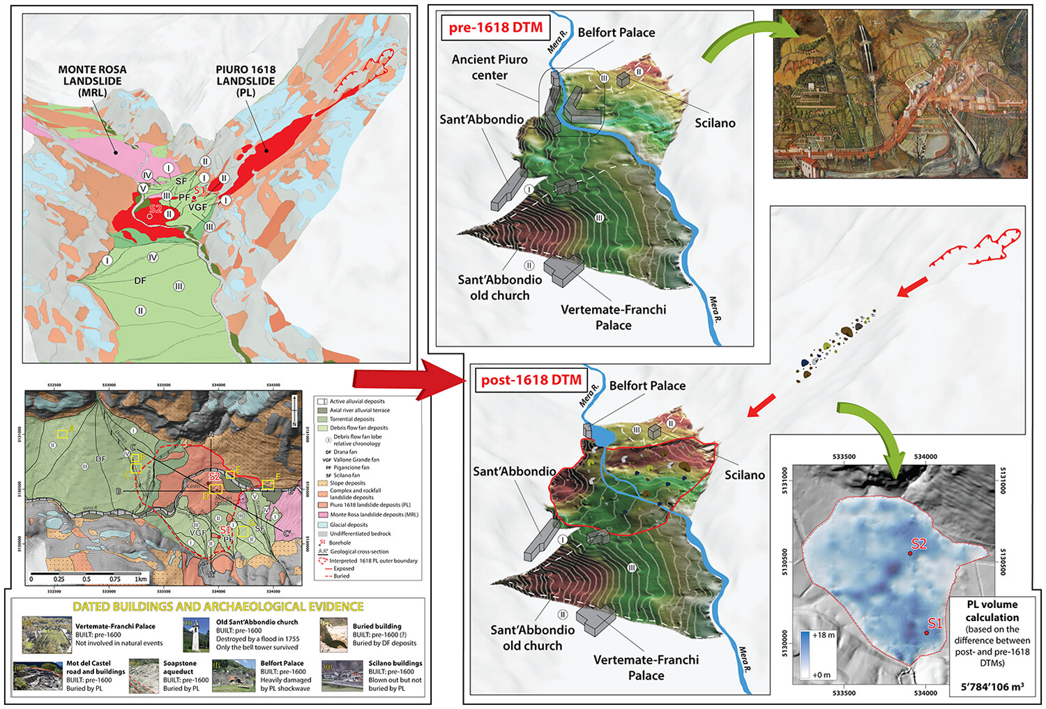
Considering the catastrophic 1618 landslide as a morphological turning point, the understanding of the progressive evolution of the palimpsest landscape of Piuro made it possible to draw two DTMs depicting the pre- and post-1618 morphology of the valley bottom, useful for archaeological reconstructions and quantitative analyses.
Detection of slow-moving landslides through automated monitoring of surface deformation using Sentinel-2 satellite imagery
- First Published: 21 February 2024
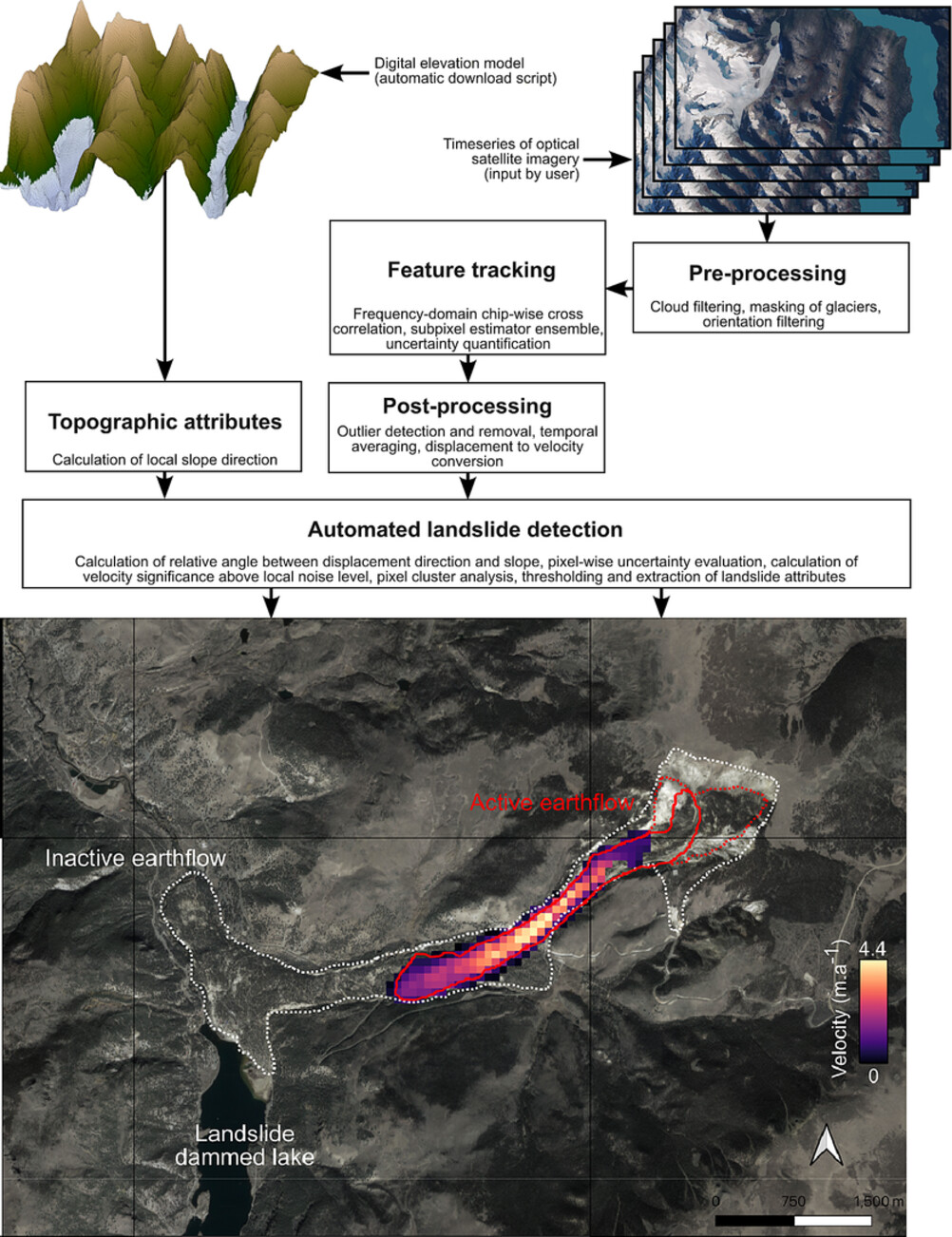
A workflow for automated detection and monitoring of slow-moving landslides using openly available satellite imagery.
Time-series InSAR monitoring of surface deformation in Yakutsk, a city located on continuous permafrost
- First Published: 02 November 2023
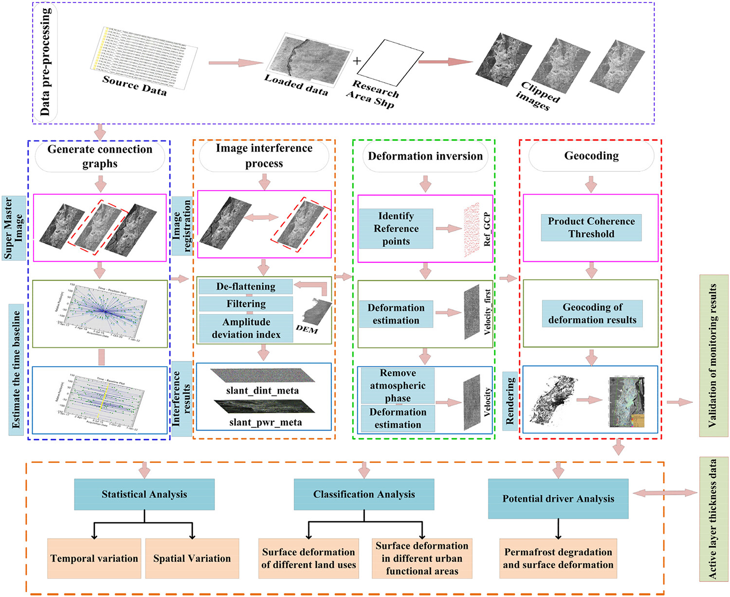
Permafrost, due to its high sensitivity to climate change and human activities, plays a crucial role in understanding the environmental sustainability of Arctic cities. However, widespread global climate warming has caused irreversible damage to the urban surface situated on permafrost. Despite this, there still remains a significant amount of uncertainty in research pertaining to this issue. Therefore, this study is designed to investigate the surface deformation of Yakutsk, the largest city situated on permafrost, using times series remote sensing techniques.
Sign up for email alerts
Tools
More from this journal
- Award Winners
- Special Issues
- State of Science
- Call for Papers - Special Issue: The geomorphic signature of marine and continental Quaternary deposits
- Call for Papers - Special Issue: Earth surface processes and climate change at the Earth’s three poles
- Call for Papers - Special Issue: Novel approaches to quantify landscape changes (Cuchlaine King Symposium 2023)
- Call for Papers - Special Issue: Extreme Events in Geomorphology (Cuchlaine King Symposium 2024)
- Call for Papers - Special Issue: Applications of Artificial Intelligence in Geomorphology
- Call for Papers - Special Issue: Influence of tectonics and climate on landscape evolution: process and modelling
- Call for Papers - Special Issue: Fluvial processes and landforms in the Tibetan plateau in a period of rapid climate change
- Call for Papers - Special Issue: Wood in World Rivers 5
- Call for Papers - Spatial and temporal evolution of landslides induced by global climate change
- Call for Papers - Earth-Surface Processes in the Anthropocene: Human Impact, Climate Change, and Geomorphological Responses
- ESEX Commentaries
- BACKFILES An Online Archive from 1976 to 1995
- Other Resources
Latest Virtual Special Issues:
Is there a geomorphological case for the Anthropocene?
Chaired by Stephen Tooth, with panellists Professor Tony Brown, Simon Price and Professor Andreas Lang. Are we in the Anthropocene and no longer in the Holocene? Has human activity integrated and changed natural processes? Have we created our own geological time period?