

Journal list menu

 Issue
IssueHydrological Processes: Volume 37, Issue 3
March 2023
Export Citations
Download PDFs
ISSUE INFORMATION
COMMENTARIES
AI tools such as ChatGPT will disrupt hydrology, too
- First Published: 27 February 2023
NOTE
Fine scale 20-year timeseries of plantation forest evapotranspiration for the lower limestone coast
- First Published: 22 February 2023
RESEARCH ARTICLES
Surface-to-tile drain connectivity and phosphorus transport: Effect of antecedent soil moisture
- First Published: 17 February 2023

Tile discharge increases once precipitation amount exceeds the soil moisture deficit (i.e., SMD + Precipitation = 0). The increase in discharge is largely the result of the mobilization of stored pre-event water, as event water contributions remain consistent across antecedent wetness conditions. The shift from dry to wet antecedent conditions and the changing water sources results in a decrease in dissolved reactive phosphorus (DRP) concentration.
Groundwater recharge in northern New England: Meteorological drivers and relations with low streamflow
- First Published: 16 February 2023
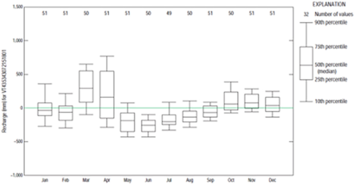
What controls the interannual variability of groundwater recharge in northern New England? Precipitation, temperature, atmospheric pressure and height, and various teleconnection indices were tested against recharge using random forest machine learning models. Precipitation outside of months which typically have the largest recharge were the most important variables in explaining recharge. The interannual variability of summer/fall minimum streamflows was related to summer precipitation at all wells in the study area and to recharge-year recharge and summer air temperatures at only a few wells.
Water use patterns of dominant species of riparian wetlands in arid areas
- First Published: 20 February 2023
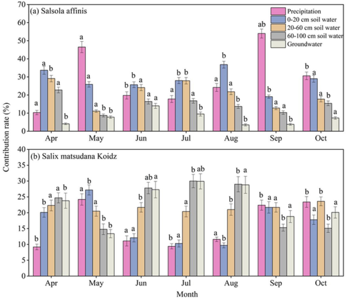
(1) Salix matsudana Koidz uses 20–100 cm soil water and groundwater. (2) Salsola affinis uses 0–60 cm soil water. (3) The surface evaporation depth reached 60 cm in riparian wetlands. This paper uses stable isotope technology (δD and δ18O) and Iso-Source model to study the seasonal variation and difference in water use patterns of S. affinis and S. matsudana Koidz in a typical riparian wetland in the arid area. The research results help to understand the ecological hydrological cycle of riparian wetlands in arid areas and ecological management and restoration of riparian wetlands in arid areas.
Transport of nutrients into the southern Gulf of Mexico by the Grijalva–Usumacinta rivers
- First Published: 22 February 2023
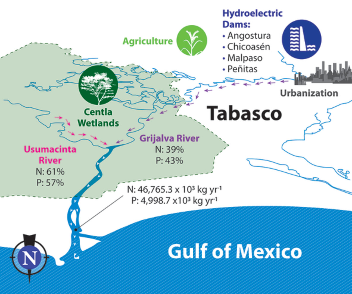
- The Grijalva–Usumacinta river system is the second freshwater input and an important source of nutrients for the Gulf of Mexico.
- Higher nutrient and chlorophyll concentrations were measured in the Grijalva River, as result of higher human pressures related to urbanization and agriculture.
- Seasonal patterns in discharge and nutrient concentration were stronger in the Usumacinta River, evincing the flow regulation in the Grijalva.
- The Usumacinta River showed higher nutrient load, although the Grijalva River transports more soluble reactive phosphorus and ammonium.
Effect of iron on biological clogging in porous media: Implications for managed aquifer recharge
- First Published: 22 February 2023

The combined biological-chemical clogging was closely related to the iron concentration. An iron water quality target in recharge water for MAR should be <0.3 mg/L to mitigate clogging effects.
Multiple timescales of streambed flux variability in two perennial mountain-front streams
- First Published: 23 February 2023
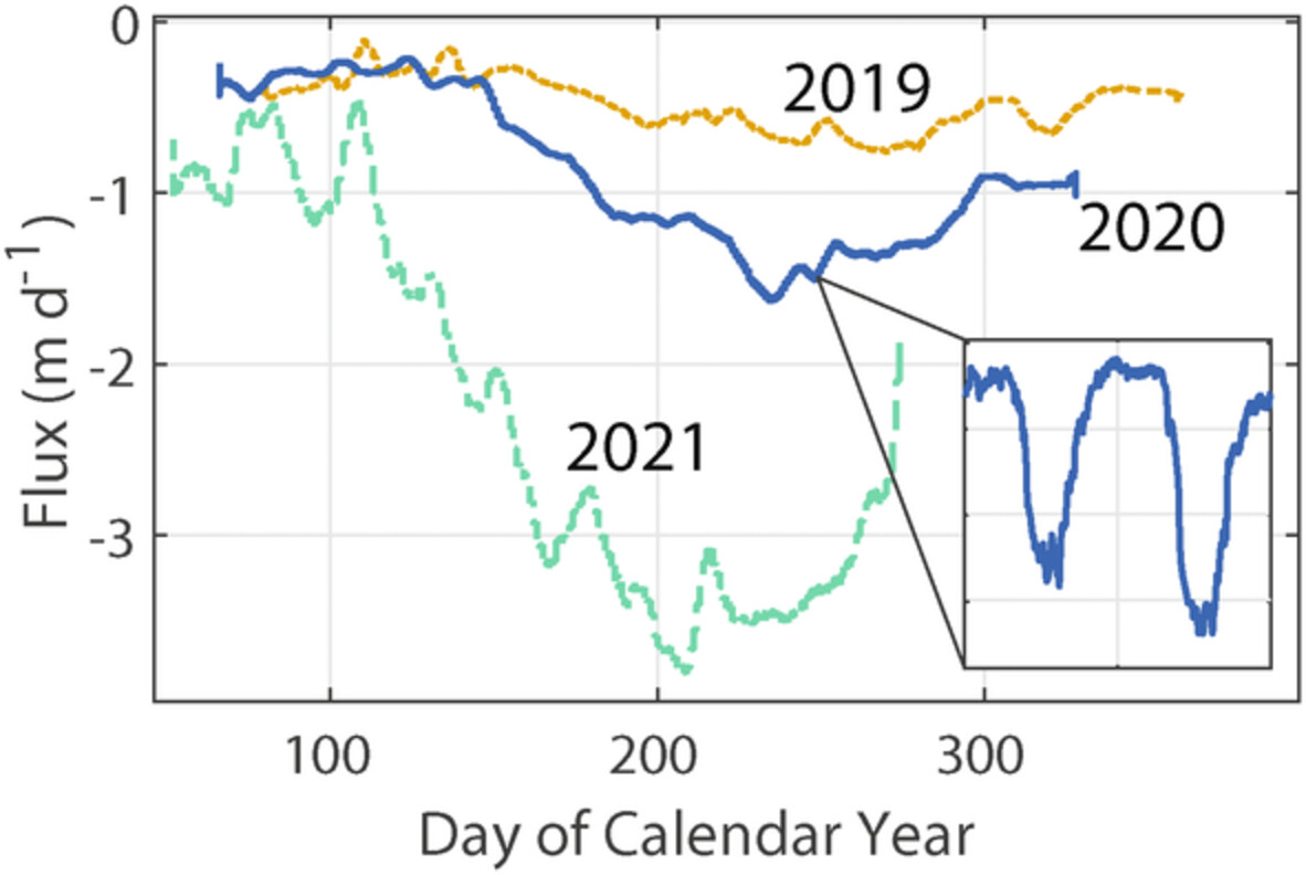
A 3-year streambed flux dataset reveals substantial temporal variability at sub-daily, daily, and inter-annual timescales with implications for groundwater recharge and hyporheic exchange.
Assessment of flood dynamics in a mountain stream using high-resolution river flow records
- First Published: 23 February 2023
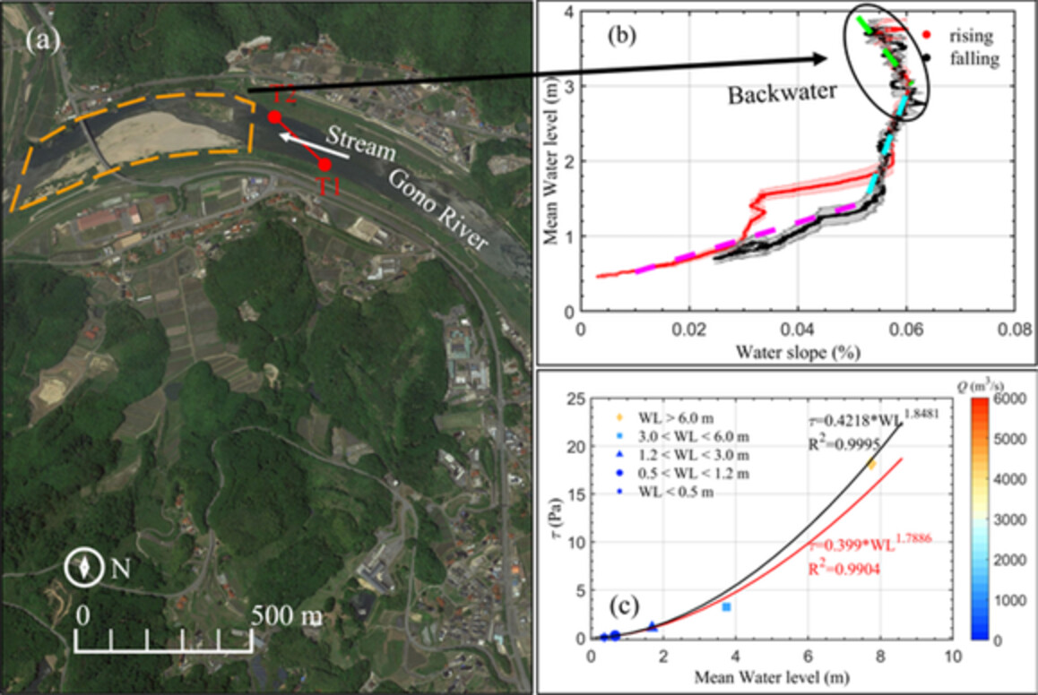
Fluvial acoustic tomography system was used to determine key streamflow characteristics (i.e., rainfall, backwater effects) based on a high temporal resolution of 10 min and long-term observations of streamflow in a mountainous river.
Characteristic time scales of evaporation from a subarctic reservoir
- First Published: 24 February 2023

The annual evaporation from a subarctic reservoir was measured at 442 mm on average based on a 4-year eddy-covariance measurement campaign. This value was adjusted to 590 mm following the assessment of the associated energy balance, which revealed an underestimation of about 26% of the turbulent fluxes. More precisely, 84% of the total annual evaporation took place from August to December only when the atmosphere was mostly unstable. Moreover, the sensible heat flux was negative from January to July and peaked in December by 50% higher than the latent heat flux. Finally, evaporation was mainly controlled by wind speed and air humidity, whereas it did not seem to be affected by the duration of reservoir freeze-up.
Random fractional partial differential equations and solutions for water movement in soils: Theory and applications
- First Published: 28 February 2023
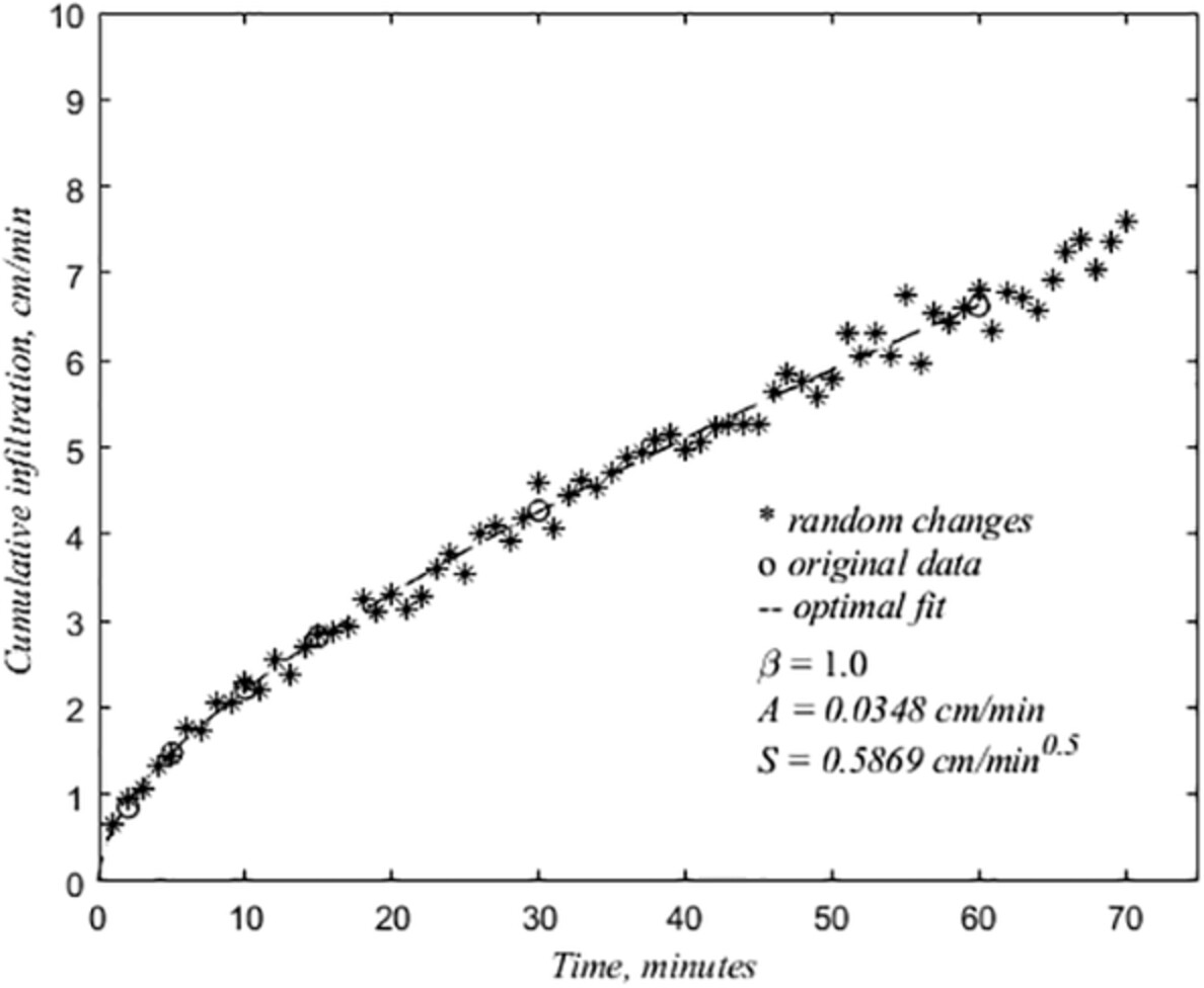
Computed random fluxes into and out of the soil, , from the measured water content, , and hydraulic conductivity, . The random influx is computed as an inverse problem using the methods based on random fractional partial differential equations presented in this paper. The methods have been applied to data from single site and a catchment.
How do hydrologists perceive watersheds? A survey and analysis of perceptual model figures for experimental watersheds
- First Published: 28 February 2023
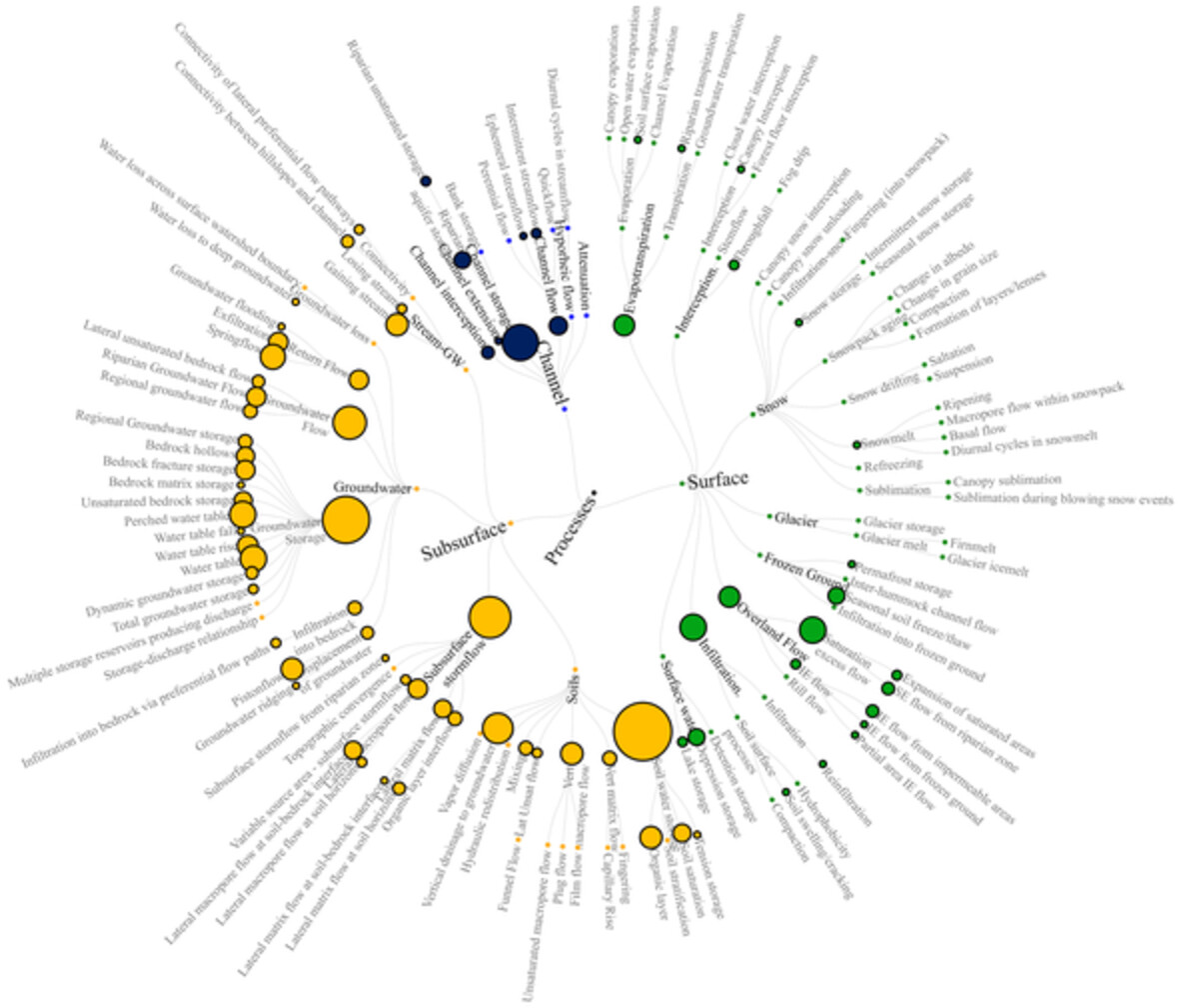
To describe hydrological process knowledge in experimental watersheds, experts commonly use a ‘perceptual model’, a figure that illustrates the watershed and its runoff processes. We surveyed the literature and found 63 perceptual model figures, then analysed the information in each figure including counting and categorizing the stores and fluxes using a taxonomic classification. We evaluated and made recommendations for perceptual models as a method to share hydrological process information.
Long-term and seasonal variation of open-surface water bodies in the Yellow River Basin during 1990–2020
- First Published: 28 February 2023
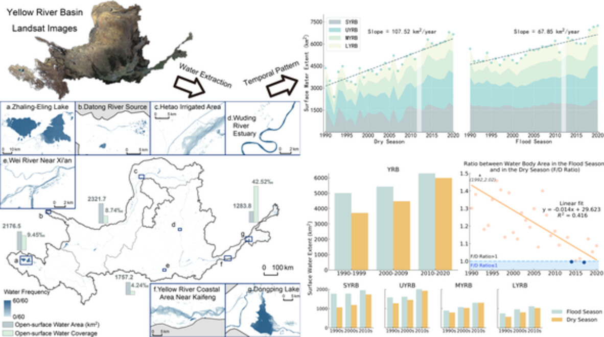
Open-surface water bodies are essential terrestrial water sources and ecosystem service providers. In Yellow River Basin, the second largest basin in China, open-surface water bodies have been increasing and the seasonal difference has been declining during 1990–2020 despite a decreasing discharge. Anthropogenic activity, for example water conservation projects contributed to this trend, ensuring water resource availability in this populated arid to semi-arid area.
On strictly enforced mass conservation constraints for modelling the Rainfall-Runoff process
- First Published: 03 March 2023
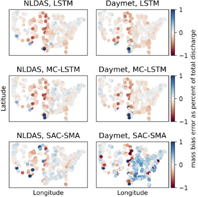
We test a hypothesis that mass conservation constraints restrict a model's ability to compensate for disinformation from input data. Our results are presented generally in terms of constraints enforced on deep learning (DL) and conceptual model architecture. Our findings demonstrate:
- Conservation may not be a good foundation for watershed scale hydrological theory.
- Disinformative data is not generally a major source of modelling error.
- DL models compensate for systematic biases in the input data on a per-event basis.
Influence of vegetation lodging on the flow regime and resistance characteristic of overland flow
- First Published: 03 March 2023
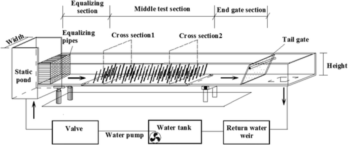
To clarify the effect of vegetation lodging on overland flow, an indoor flume experiment of vegetation gradient lodging combination and lodging angle was carried out. The results show that it is reasonable to use a uniform lodging angle to simulate the influence of gradient lodging on the overland flow resistance. The influence of vegetation lodging angle on flow state changes and resistance mechanism is studied, and a calculation model of resistance coefficient of lodging vegetation in non-submerged state is established.
Simulating spatial variability of groundwater table in England and Wales
- First Published: 03 March 2023
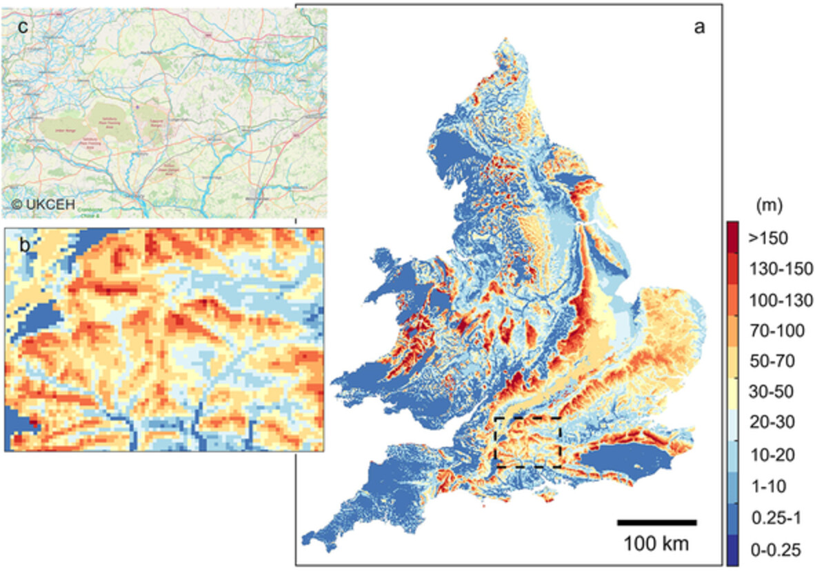
Using a numerical model, we simulate steady-state groundwater head at 1 km spatial resolution over entire England and Wales. The figure shows simulated groundwater table depth in metres below the land surface. Our results demonstrate that at a large spatial scale, mainly atmospheric forcing controls the spatial variability of groundwater head while at a smaller scale, the impacts of lateral flow are substantial.
Variations of stable isotope in Typhoon Lupit (2021) rainfall and its response to upstream convective processes
- First Published: 04 March 2023
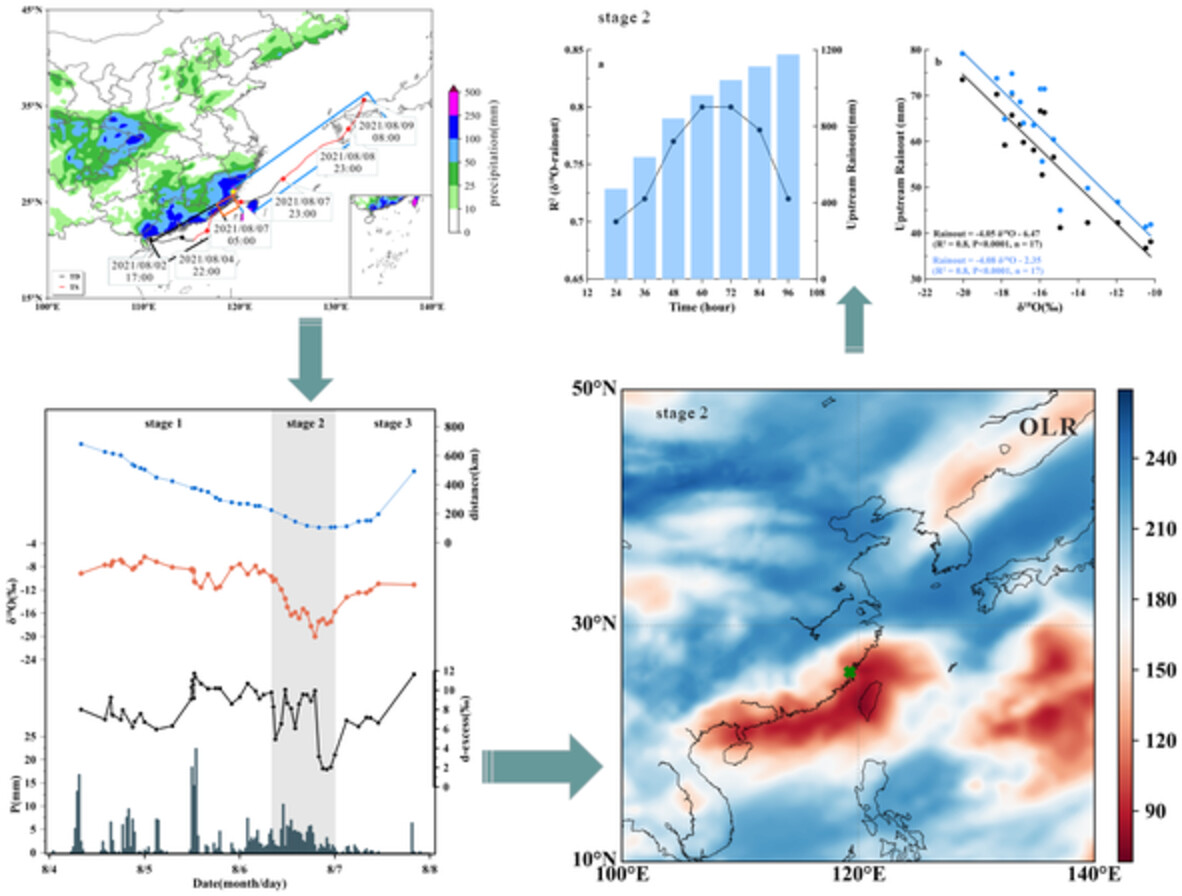
Typhoon Lupit had significant fluctuations in δ18O values, exhibiting a three-stage variation characteristic with distinctly negative δ18O values in the second stage. The extremely negative δ18O values were because of accumulated convective activity and continuous precipitation as they travelled towards the centre of the typhoon.
Forecasting the human and climate impacts on groundwater resources in the irrigated agricultural region of North China Plain
- First Published: 06 March 2023
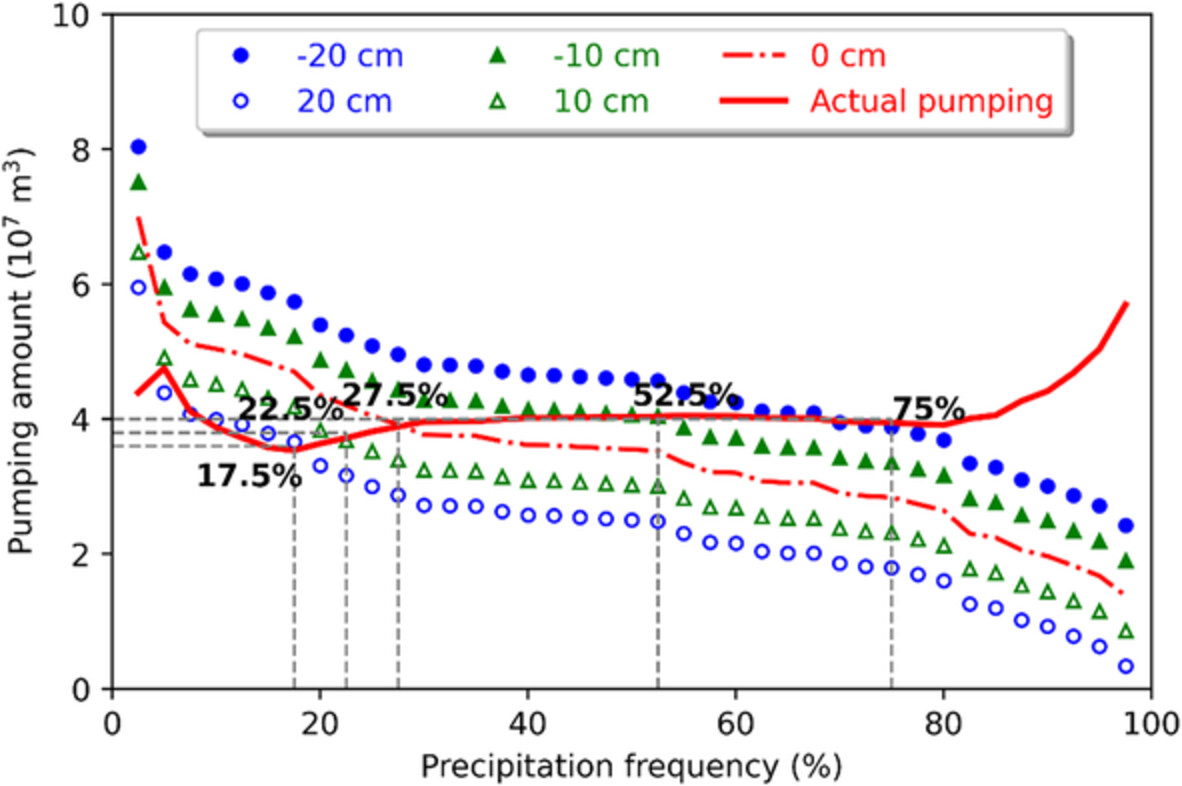
This study demonstrated that the ‘amplifying effect’ of anthropogenic activities is significant when climate tends to become dry because more shallow groundwater pumping is expected to maintain regional water resources demand under dry climate in the region highly relying on groundwater.
Impact of high-permeability preferential flow zones on pumping-induced airflow in unconfined aquifer
- First Published: 08 March 2023
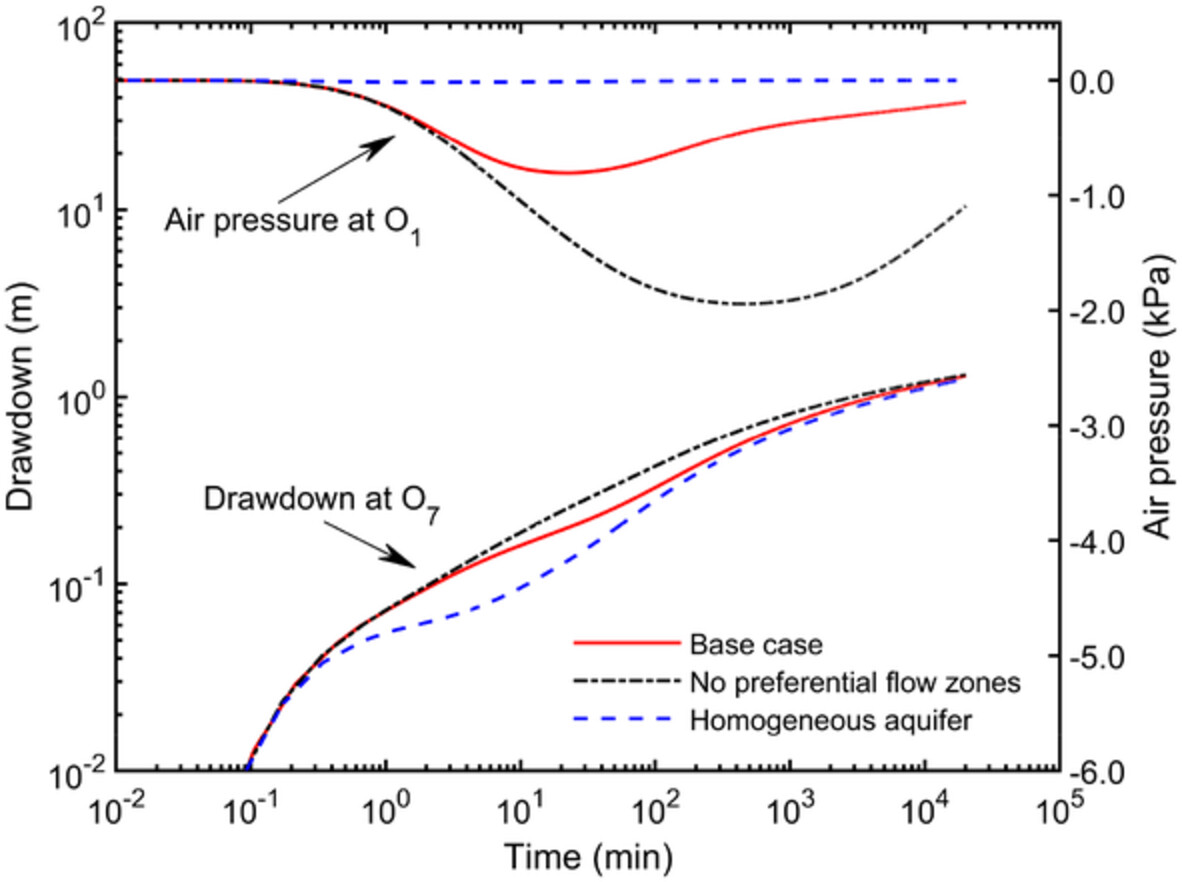
Effects of preferential flow on air pressure in unsaturated zone and drawdown in saturated zone
Spatiotemporal changes of nitrate retention at the interface between surface water and groundwater: Insight from watershed scale in an elevated nitrate region
- First Published: 09 March 2023
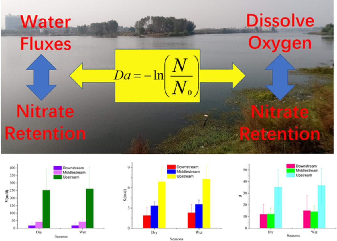
The relationship between the nitrate retention with water fluxes and dissolve oxygen at the interface between surface water and groundwater.
Increasing fire frequency may trigger eco-hydrologic divergence
- First Published: 14 March 2023
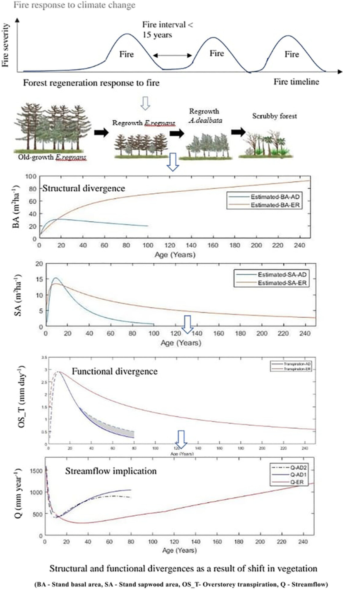
The replacement of Eucalyptus regnans with Acacia dealbata forests under increasing fire frequencies would result in a significant decrease in annual and decadal Et, inferring a divergence in eco-hydrologic functions. The data suggest that significant divergence in forest structure, Et and water yield between E. regnans and A. dealbata forests.
Upgraded closed-form soil hydraulic functions from oven dryness to saturation
- First Published: 20 March 2023
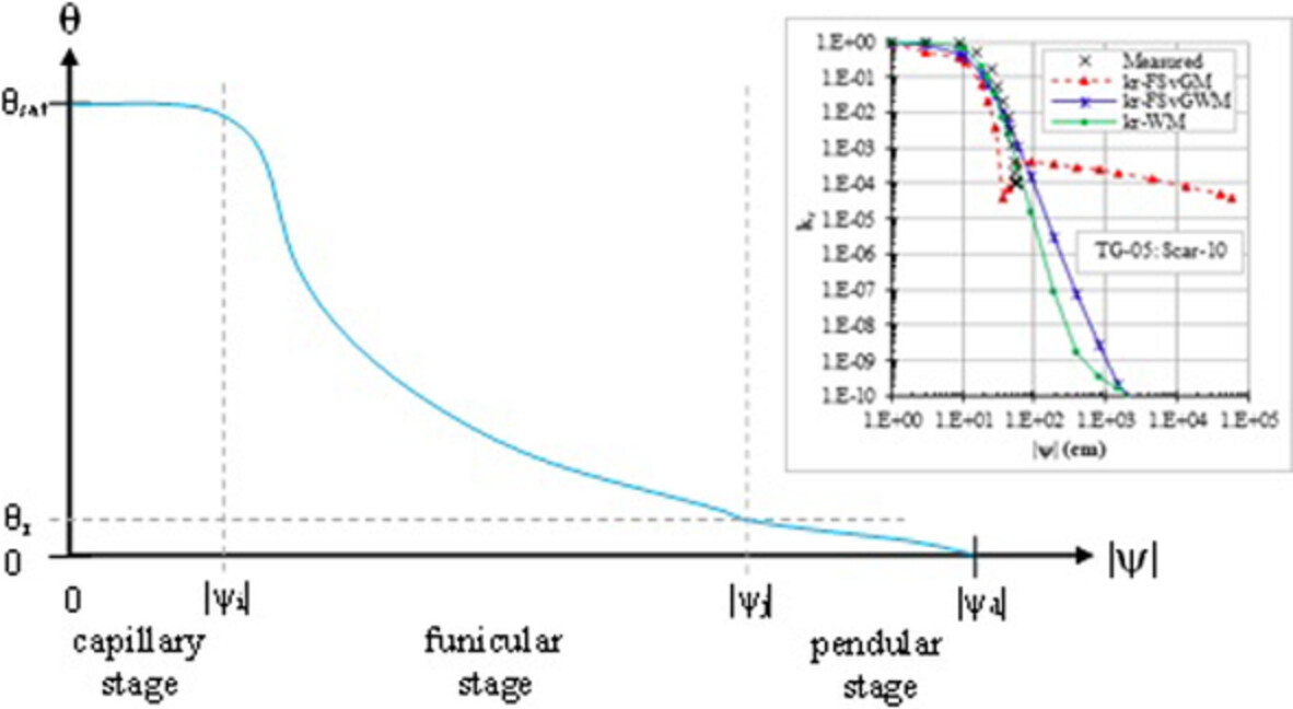
The three wet ranges of soil hydraulics are most accurately described by the updated functions.
SPECIAL ISSUE PAPERS
Ground-based infrared thermometry reveals seasonal evapotranspiration patterns in semiarid rangelands
- First Published: 10 February 2023
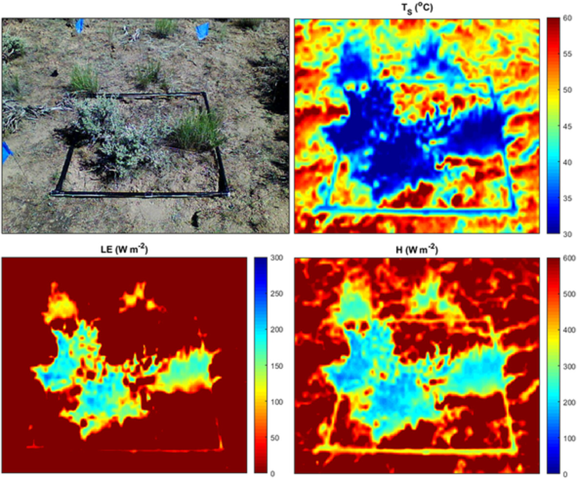
Ground-based thermal infrared (TIR) temperature can predict spatio-temporally continuous land surface energy balance. Proposed TIR methods showed good agreement with ground-based eddy covariance observations in turbulent heat fluxes for most cases. Predictability declined substantially as the fraction of senescent foliage increased in dry conditions.
Quantifying the impacts of hydraulic infrastructure on tropical streamflows
- First Published: 20 February 2023
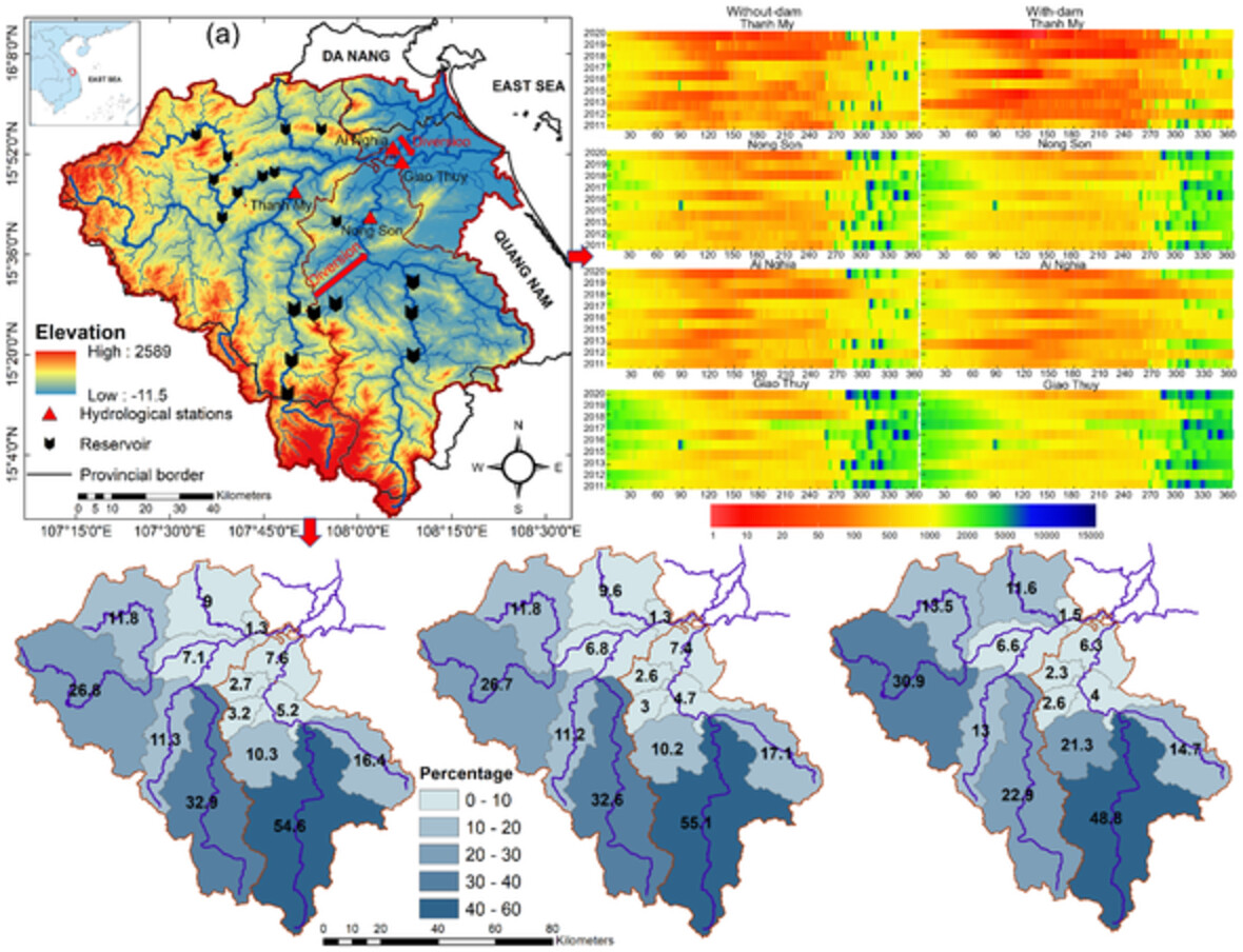
Impacts of hydraulic infrastructures and contributions of the sub-basins on streamflow in the Vu Gia Thu Bon River basin, Vietnam
A data-driven approach for flood prediction using grid-based meteorological data
- First Published: 22 February 2023

A data-driven approach based on the NASA GLDAS data is proposed for flood prediction with the assistance of the Gamma Test. A runoff generation model together with a routing model based on the LSTM network is established. The GLDAS meteorological data are used directly to simulate the streamflow at the catchment outlet by the integrated model.
Resistance of river ice covers to mobilization and implications for breakup progression in Peace River, Canada
- First Published: 05 March 2023
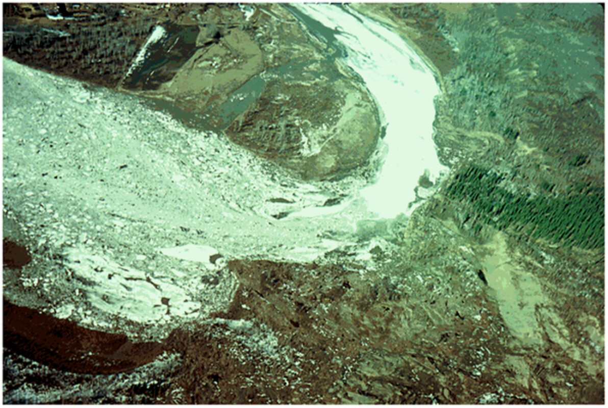
Assessing ecological and socioeconomic impacts of ice-forming rivers across Europe, Asia and North America requires predictive capacity for related processes, including ice jam flooding. Using a physics-based breakup onset criterion, I develop and successfully test explicit expressions for the various components of the resistance of ice covers to mobilization, which partly controls breakup evolution and ice jam formation.
Sign up for email alerts
Tools
More from this journal
- Aims and Scope
- Collections/ Special Issues
- Call for Papers: Laboratory and field experiments on soil and rainfall characteristics for studying water erosion processes
- Call for Papers: Drought dynamics and vulnerability
- Pluvial Flooding: Maturing process understanding from data scarcity into data abundance
- Call for Papers: Hydrological processes in lowlands and plains
- Call for Papers: Preferential flow and eco-hydrological processes in the vadose zone
- MG Anderson Awards
- Top Cited Awards
- CHINA Collection
- SEO Guidelines for Authors
HP's Award Winning Articles
We're delighted to announce our 2024 prize winners!
MG Anderson Award
Forest cover lessens hurricane impacts on peak streamflow
Jazlynn Hall, Martha Scholl, James Shanley, Serena Matt, María Uriarte
Top Cited Paper
On strictly enforced mass conservation constraints for modelling the Rainfall-Runoff process
Jonathan M. Frame, Frederik Kratzert, Hoshin V. Gupta, Paul Ullrich, Grey S. Nearing
Top Cited Invited Commentary
Benchmarking hydrological models for an uncertain future
Keith Beven