

Journal list menu

 Issue
IssueHydrological Processes: Volume 34, Issue 16
3403-361330 July 2020
Export Citations
Download PDFs
ISSUE INFORMATION
USING WATER AGE TO EXPLORE HYDROLOGICAL PROCESSES IN CONTRASTING ENVIRONMENTS
Isotope-aided modelling of ecohydrologic fluxes and water ages under mixed land use in Central Europe: The 2018 drought and its recovery
- Pages: 3406-3425
- First Published: 31 May 2020
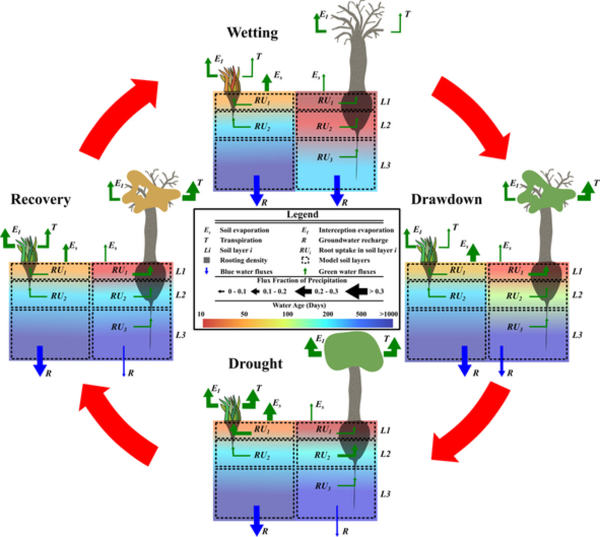
Cycle of pre-drought, drought, and recovery of “green” and “blue” water fluxes and soil water ages of grassland and forested sites.
RESEARCH ARTICLES
Suspended sediment monitoring in alluvial gullies: A laboratory and field evaluation of available measurement techniques
- Pages: 3426-3438
- First Published: 21 May 2020
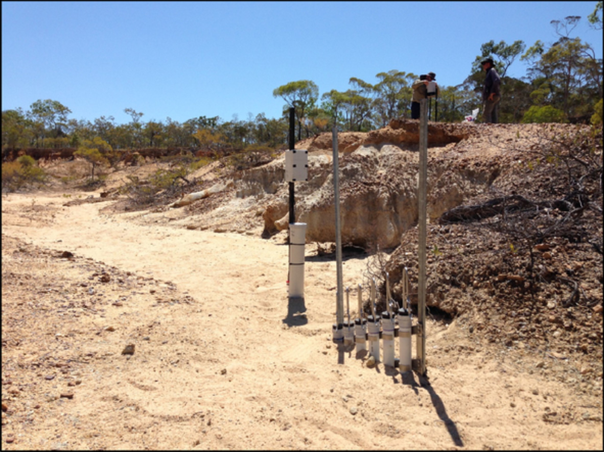
This study describes a laboratory and field-based assessment of the performance of suspended sediment monitoring techniques commonly used in gullies. We also evaluate a recently-described method; the pumped active suspended sediment sampler, which has been modified for monitoring suspended sediment in gully systems. The methods evaluated were influenced by fluvial processes that were exacerbated by the sediment dynamics of gullies (e.g., rapid vertical movement of the channel bed during flow events) or sampling bias (e.g., underestimation suspended sand concentration).
Quantifying the role of karstic groundwater in a snowmelt-dominated hydrologic system
- Pages: 3439-3447
- First Published: 26 May 2020
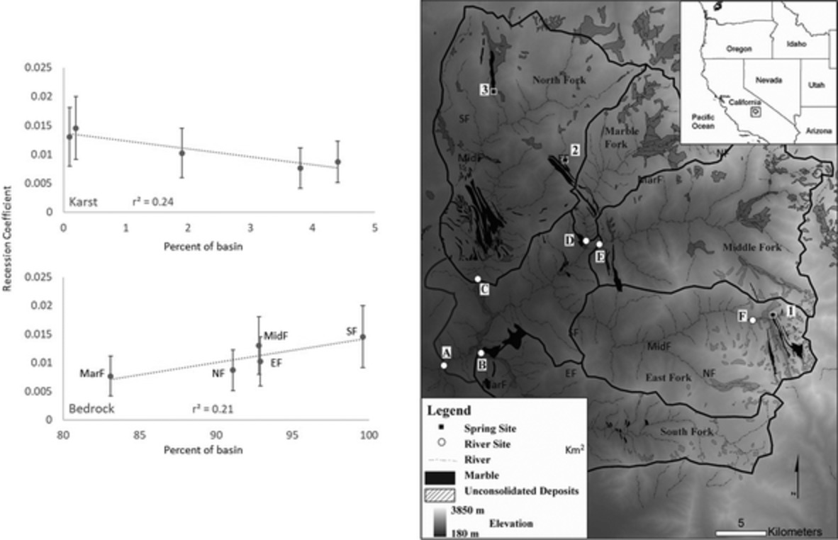
In snowmelt-dominated river systems, groundwater plays a key role in maintaining base flow during dry periods. Karst groundwater systems, when present, play a large role in delaying discharge to the rivers. Even when these karst systems are spatially limited, river base-flow behaviours can best be explained by the amount of karst present in the river basin.
Rainstorm-generated sediment yield model based on soil moisture proxies (SMP)
- Pages: 3448-3463
- First Published: 13 May 2020
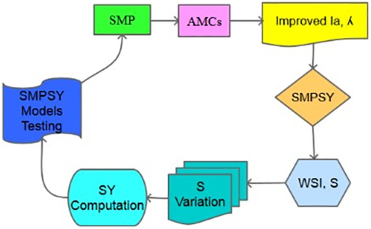
- Incorporating SMP in the lumped conceptual SCS-CN based sediment yield.
- We develop SMP-based sediment yield models (SMPSY) by coupling the Ia-λ model, and SMA concept.
- The SMPSY models incorporate watershed storage index (S) to avoid sudden jump in sediment yield computations.
Using hysteretic behaviour and hydrograph classification to identify hydrological function across the “hillslope–depression–stream” continuum in a karst catchment
- Pages: 3464-3480
- First Published: 02 May 2020
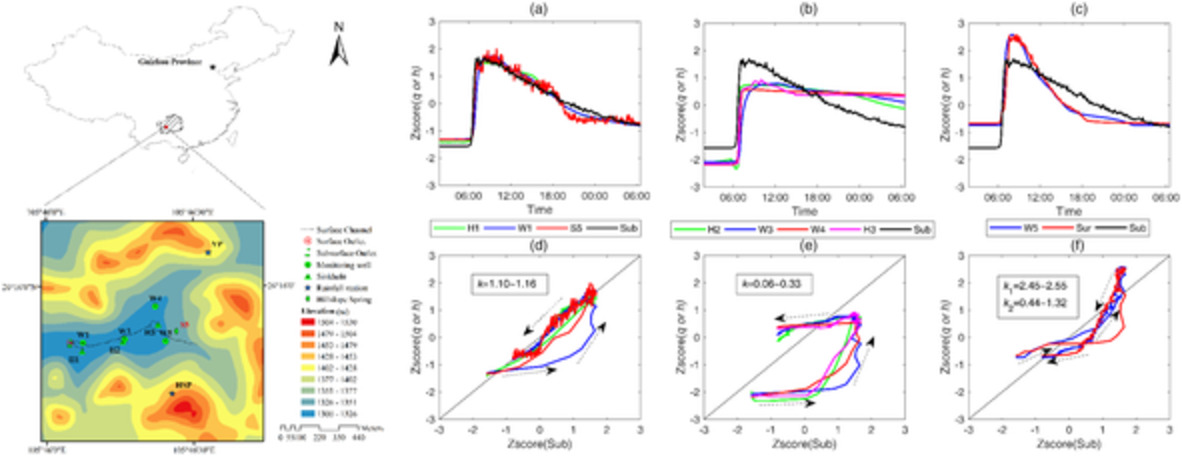
Hydrographs similarity and hysteresis indicates that the aquifer types, storage and permeability control hydrological function across the “hillslope–depression–stream” continuum in a karst catchment. When depression storage deficits are filled during consecutive rainfall events, depression hydrographs at the high permeability sites are almost synchronous or exhibit a monotonous function with the hydrographs at the outlet. Preferential flow paths in fractured rocks and conduits enhance flow connectivity between hillslopes and the out, propagating pressure wave over longer distances.
Geostatistical features of streambed vertical hydraulic conductivities in Frenchman Creek Watershed in Western Nebraska
- Pages: 3481-3491
- First Published: 22 May 2020
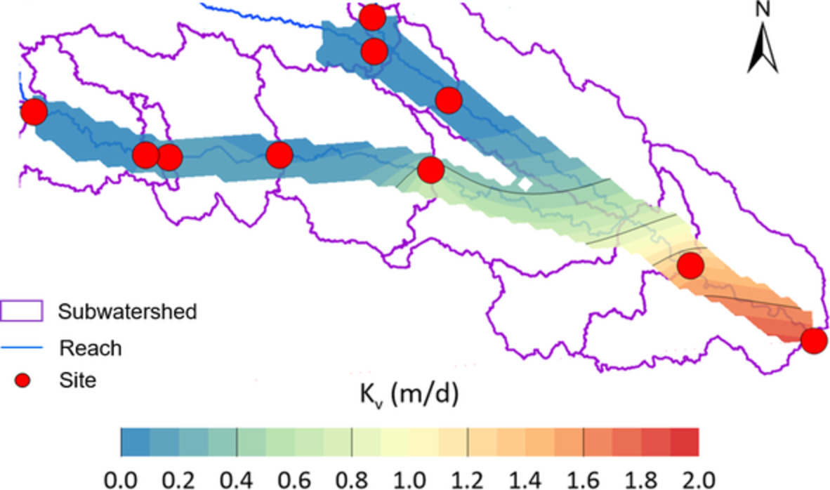
- At watershed-scale, geostatistical analysis shows that using the geometric means of the 10 sites performs better than using either all the Kv values from the 93 permeameter tests or 10 Kv values from the middle transects and centre permeameters
- Within channel bends, higher spatial variability in streambed Kv was observed across stream channels than along stream channels.
- Meandering channels showed a more heterogeneous distribution of streambed Kv when compared to straight channels.
Water uptake of riparian plants in the lower Lhasa River Basin, South Tibetan Plateau using stable water isotopes
- Pages: 3492-3505
- First Published: 25 May 2020
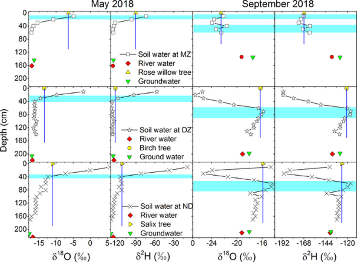
The H-O isotopic values of soil water and plant water varied greatly with season. Mature plants gained deep soil water but young plant did not in the warm-wet period. Young plants got surface soil water but mature plants did not in the cold-dry period. Plant types did not affect water uptake patterns for mature plants.
Isotopic variation in groundwater across the conterminous United States – Insight into hydrologic processes
- Pages: 3506-3523
- First Published: 26 May 2020
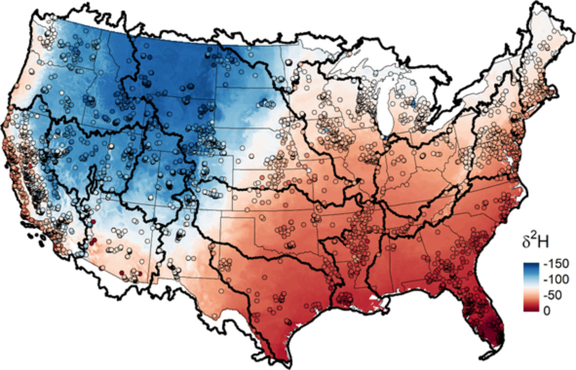
Stable isotopes of water (δ2H and δ18O) provide information on the water source and the hydrological processes that affect it as it moves through the hydrosphere. Here, we developed the first isoscape of groundwater δ2H and δ18O for the conterminous United States based on a random forest model using environmental variables as predictors (figure). We also calculated the seasonal recharge efficiency and proportion for several 1000 locations and used these results to make inferences on the hydrologic and environmental processes that affect groundwater systems across the United States.
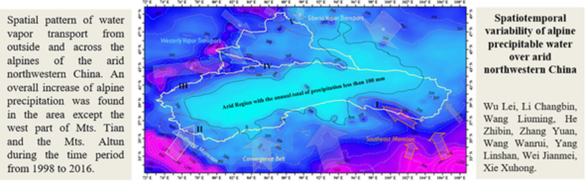
Spatiotemporal variability of alpine precipitable water over arid northwestern China
- Pages: 3524-3538
- First Published: 28 May 2020
Multiple-indicator study of the response of groundwater recharge sources to highly turbid river water after a landslide in the Tedori River alluvial fan, Japan
- Pages: 3539-3554
- First Published: 04 May 2020
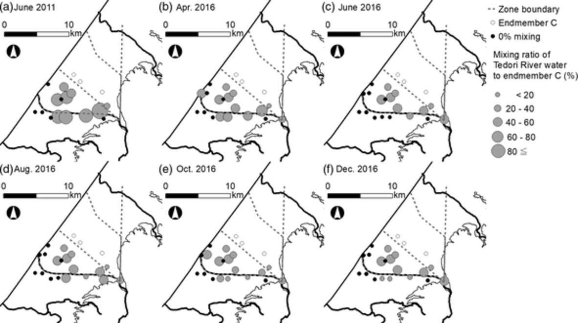
This study applied multiple water quality analyses to investigate transient changes in groundwater recharge sources in response to river turbidity caused by a large landslide in 2015. Mixing ratios of the river water with groundwater samples near the river, estimated by a two-endmember mixing model based on strontium isotope and concentration, decreased along the left bank and in the middle stream area during 2016.
Land use change effects on catchment streamflow response in a humid tropical montane cloud forest region, central Veracruz, Mexico
- Pages: 3555-3570
- First Published: 10 May 2020
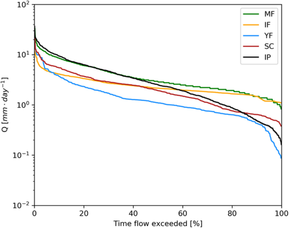
- Naturally regenerating cloud forests promote hydrologic services compared to that of mature forest (MF).
- Forty years of intense pasture management was found to have degraded the soil hydraulic properties of IP; reducing its infiltration capacity, causing a fivefold greater peak flow response and a lower baseflow compared to MF.
- Shade coffee (SC) alternatives exhibited a high capacity to modulate peak flows comparable to that of MF and an intermediate capacity to sustain baseflow.
Establishing a threshold for rainfall-induced landslides by a kinetic energy–duration relationship
- Pages: 3571-3581
- First Published: 21 May 2020
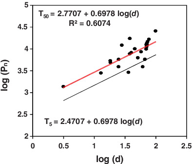
Many investigators have attempted to define the threshold of landslide failure, that is, the level of the selected climatic variable above which a rainfall-induced landslide occurs. The relationship between rainfall duration and kinetic power corresponding to landslides triggered by rain was used to propose a new approach to define the threshold for predicting landslide occurrence. This new method can be applied using commonly applied relationship for estimating the kinetic power per unit volume of rainfall and a new equation based on the measured raindrop size distribution.
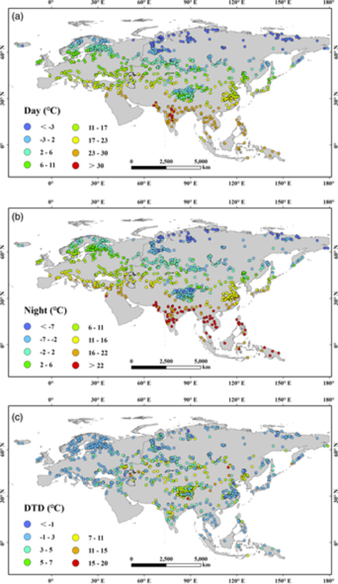
Monitoring of water surface temperature of Eurasian large lakes using MODIS land surface temperature product
- Pages: 3582-3595
- First Published: 26 May 2020
SCIENTIFIC BRIEFING
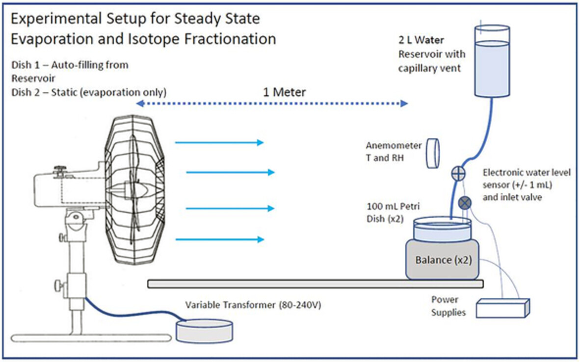
Stable isotope fractionations in the evaporation of water: The wind effect
- Pages: 3596-3607
- First Published: 17 May 2020
INVITED COMMENTARY
Deep learning, hydrological processes and the uniqueness of place
- Pages: 3608-3613
- First Published: 17 May 2020
Sign up for email alerts
Tools
More from this journal
- Aims and Scope
- Collections/ Special Issues
- Call for Papers: Laboratory and field experiments on soil and rainfall characteristics for studying water erosion processes
- Call for Papers: Drought dynamics and vulnerability
- Pluvial Flooding: Maturing process understanding from data scarcity into data abundance
- Call for Papers: Hydrological processes in lowlands and plains
- Call for Papers: Preferential flow and eco-hydrological processes in the vadose zone
- MG Anderson Awards
- Top Cited Awards
- CHINA Collection
- SEO Guidelines for Authors
HP's Award Winning Articles
We're delighted to announce our 2024 prize winners!
MG Anderson Award
Forest cover lessens hurricane impacts on peak streamflow
Jazlynn Hall, Martha Scholl, James Shanley, Serena Matt, María Uriarte
Top Cited Paper
On strictly enforced mass conservation constraints for modelling the Rainfall-Runoff process
Jonathan M. Frame, Frederik Kratzert, Hoshin V. Gupta, Paul Ullrich, Grey S. Nearing
Top Cited Invited Commentary
Benchmarking hydrological models for an uncertain future
Keith Beven