

Journal list menu

Export Citations
Download PDFs
Table of Contents
Sugarcane leaf return and mixing significantly reduce slope runoff and soil loss
- First Published: 06 May 2024
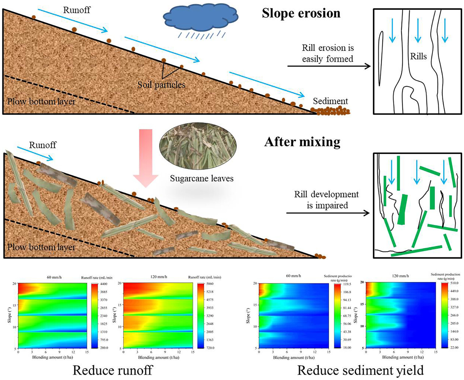
Sugarcane leaf return and mixing weakens the runoff and sediment production process on the red soil slope, and suppresses slope erosion.
Field-based estimation of cation exchange capacity using induced polarization methods
- First Published: 12 November 2024
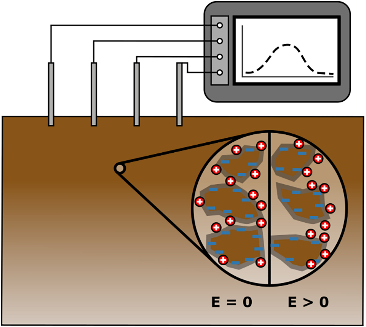
Experimental design showing electrode layout and recorded spectral induced polarization (SIP) data. The left half of the zoomed-in region shows the equilibrium state with no applied electrical field. The right half shows the situation whereby an electrical field causes the cations to migrate on the surface of mineral grains; a phenomena which can be measured with the SIP instrumentation.
Combining electrical resistivity tomography and passive seismic to characterise the subsurface architecture of a deeply weathered lateritic hill within the Avon River critical zone observatory
- First Published: 19 November 2024
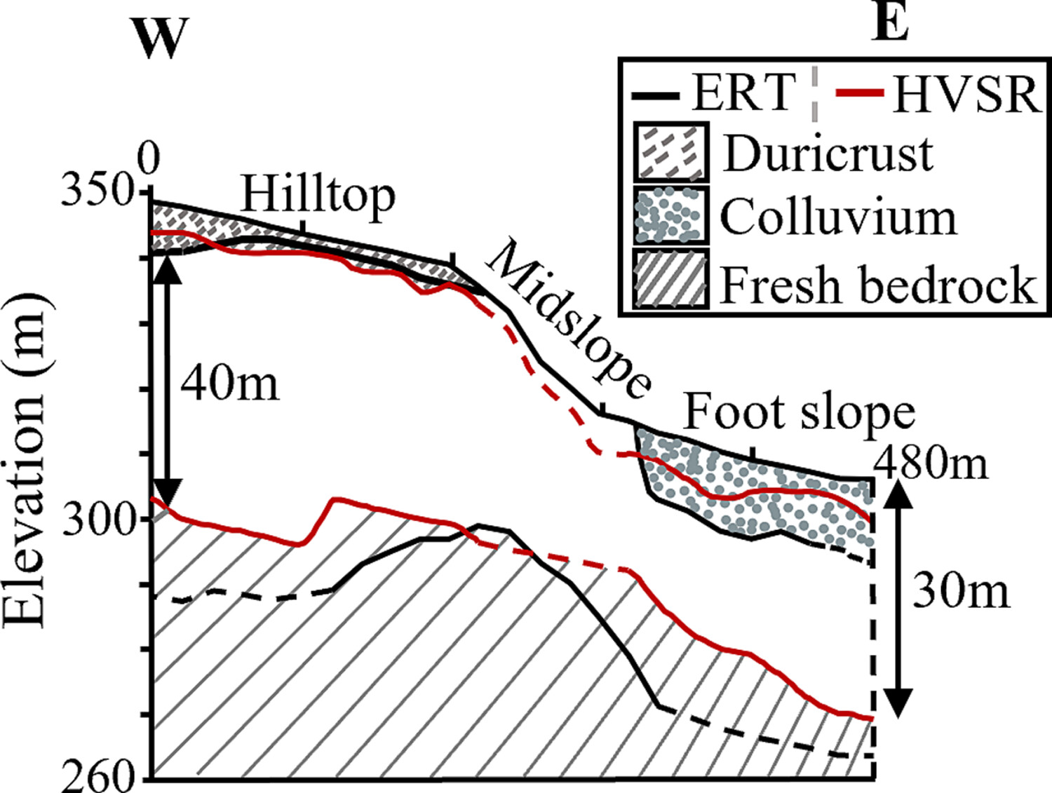
The vertical and lateral subsurface architecture of a deeply weathered lateritic Critical Zone situated above Archean granite in Western Australia is revealed and enhanced through the combination of two complementary near-surface geophysical methodologies – electrical resistivity tomography (ERT) and horizontal-to-vertical spectral ratio (HVSR) passive seismic.
Anatomy of a deep Piedmont critical zone: Evaluating hypotheses on regolith depth controls through comparison of ridge and valley boreholes
- First Published: 19 November 2024
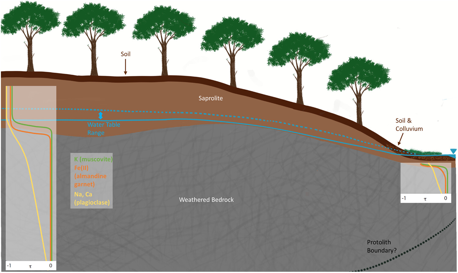
The structure of a hillslope transect in the Piedmont was explored with a ridge borehole, as well as shallow bedrock boreholes at the toe of the slope and valley. Differing dominant control mechanisms on deep bedrock weathering and saprolite initiating reactions may explain the thickness and structure of this critical zone.
Seismic and radon signatures: A multiparametric approach to monitor surface dynamics of a hazardous 2021 rock–ice avalanche, Chamoli Himalaya
- First Published: 08 May 2024
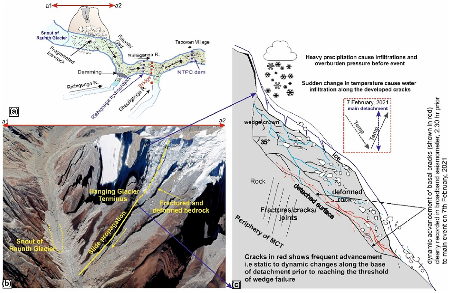
We investigate precursors to the 2021 Chamoli rock–ice avalanche in Uttarakhand, India, using radon and seismic signals. Through our analysis, we depict the dynamic changes within the source region, describing factors contributing to the avalanche. By examining recorded signals, we reconstructed dynamic nucleation phases, identified factors influencing wedge failure, and elucidated rock failure mechanisms. Utilizing a schematic model, we depict a complete process chain of the ice–rock avalanche. This integrated approach offers insights into signal generation and source dynamics, enhancing understanding prior to critical failure.
Time-dependent analysis and stability evaluation of plane rotary landslides: Insights from a case study
- First Published: 15 May 2024
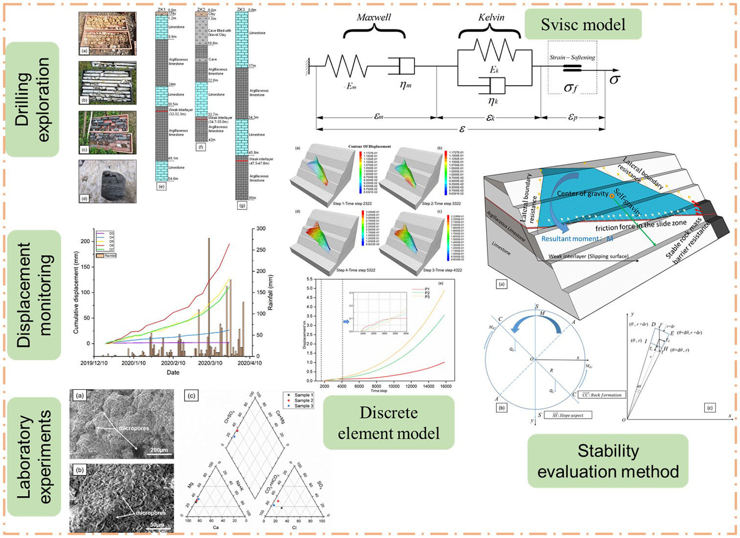
Employing a multifaceted approach-including drilling, laboratory experiments, displacement monitoring, and discrete element numerical simulation-along with an improved stability evaluation method, the deformation and failure mechanisms of plane rotary landslides were delved into.
Soil spatial heterogeneity created by river–sea interaction influences Tamarix chinensis root features in the Yellow River Delta
- First Published: 04 August 2024
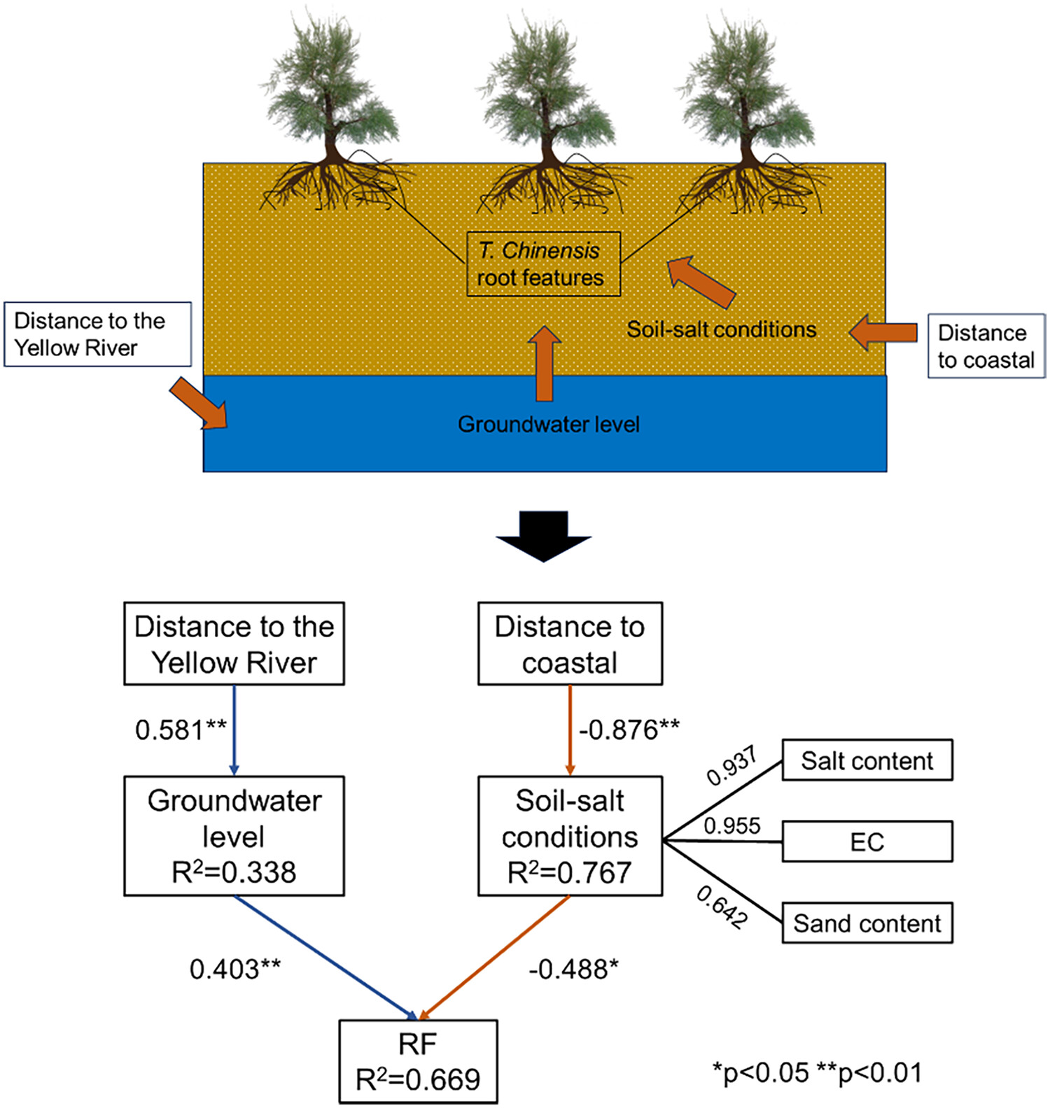
We studied Tamarix chinensis root features in six Yellow River delta communities by principal component and partial least square–structural equation modelling methods. The result showed that the geographical locations indirectly influence root features, with the Yellow River's proximity primarily affecting them through groundwater and coastal distance influencing via soil sand content and salinity.
Water content and ground temperature variations in the active layer of a rock glacier in the Central Andes of San Juan, Argentina
- First Published: 28 June 2024

Thermal and water processes within the active layer of a rock glacier, using the COUP model. Estimated active layer thickness of 5.2 m at 4012 m a.s.l. The active layer remained unsaturated.
Effects of biochar addition or grass planting on infiltrations into a sandy soil in the Loess Plateau in China
- First Published: 25 July 2024
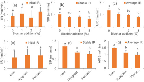
Effects of 0% biochar (C1), 1% biochar (C3), 2% biochar (C4), 3% biochar (C5) under ryegrass and 0% biochar (C2), 1% biochar (C6), 2% biochar (C7) and 3% biochar (C8) under Festuca arundinacea on sandy loam soil infiltrations were modelled with ‘bare soil + 0% biochar’ as the control (CK).
Predicting soil erosion and sediment delivery in large, data-sparse, mountainous basins
- First Published: 21 February 2024
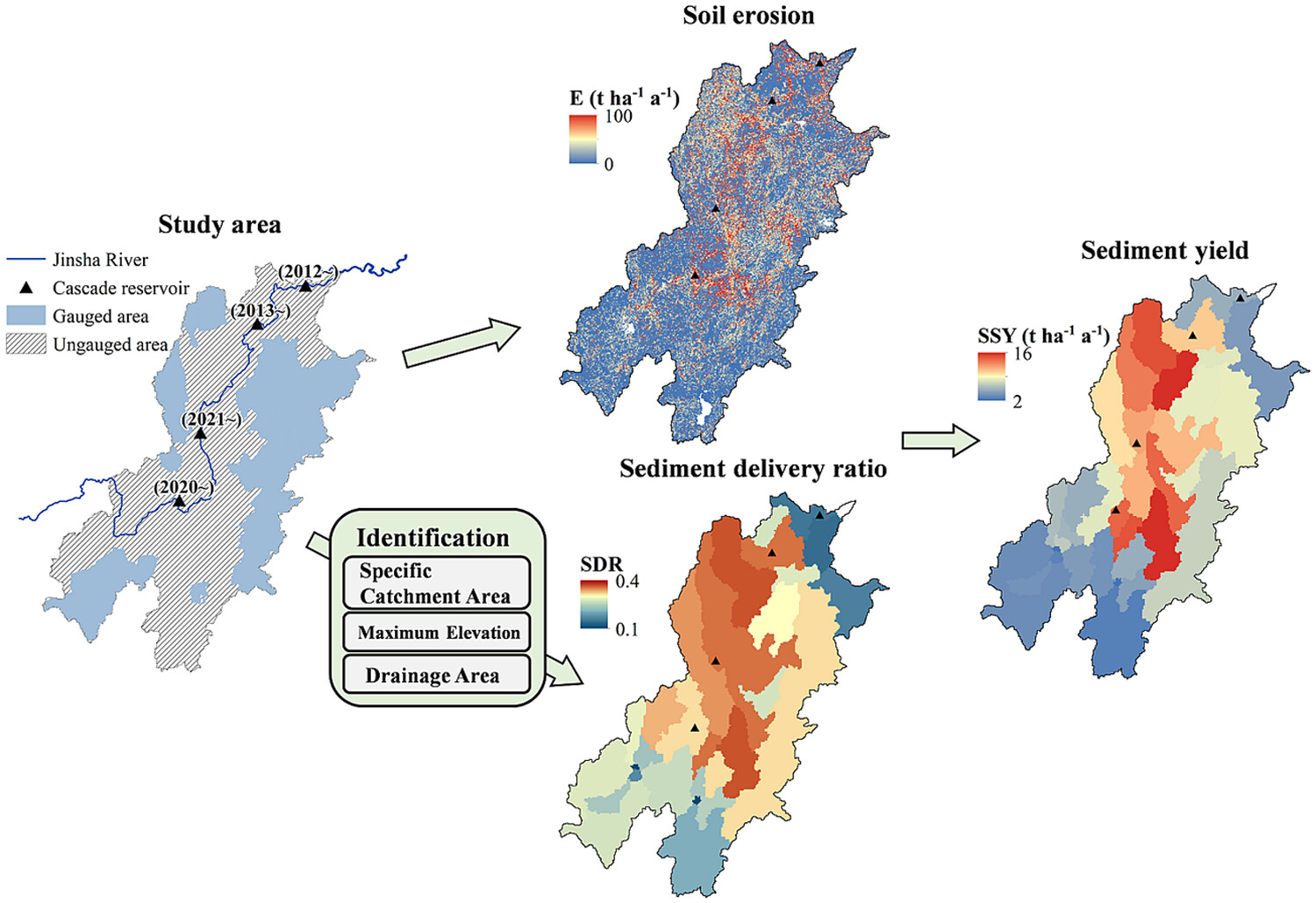
The modeling framework has low parameter requirements and good predictions, addressing the scarcity of sediment information in this vital area. Maximum elevation, specific catchment area, and drainage area jointly determine the sediment delivery ratio. Local steepness and sparse landcover were the primary cause of high erosion.
Assessing land use effects on ecohydrological partitioning in the critical zone through isotope-aided modelling
- First Published: 11 September 2023
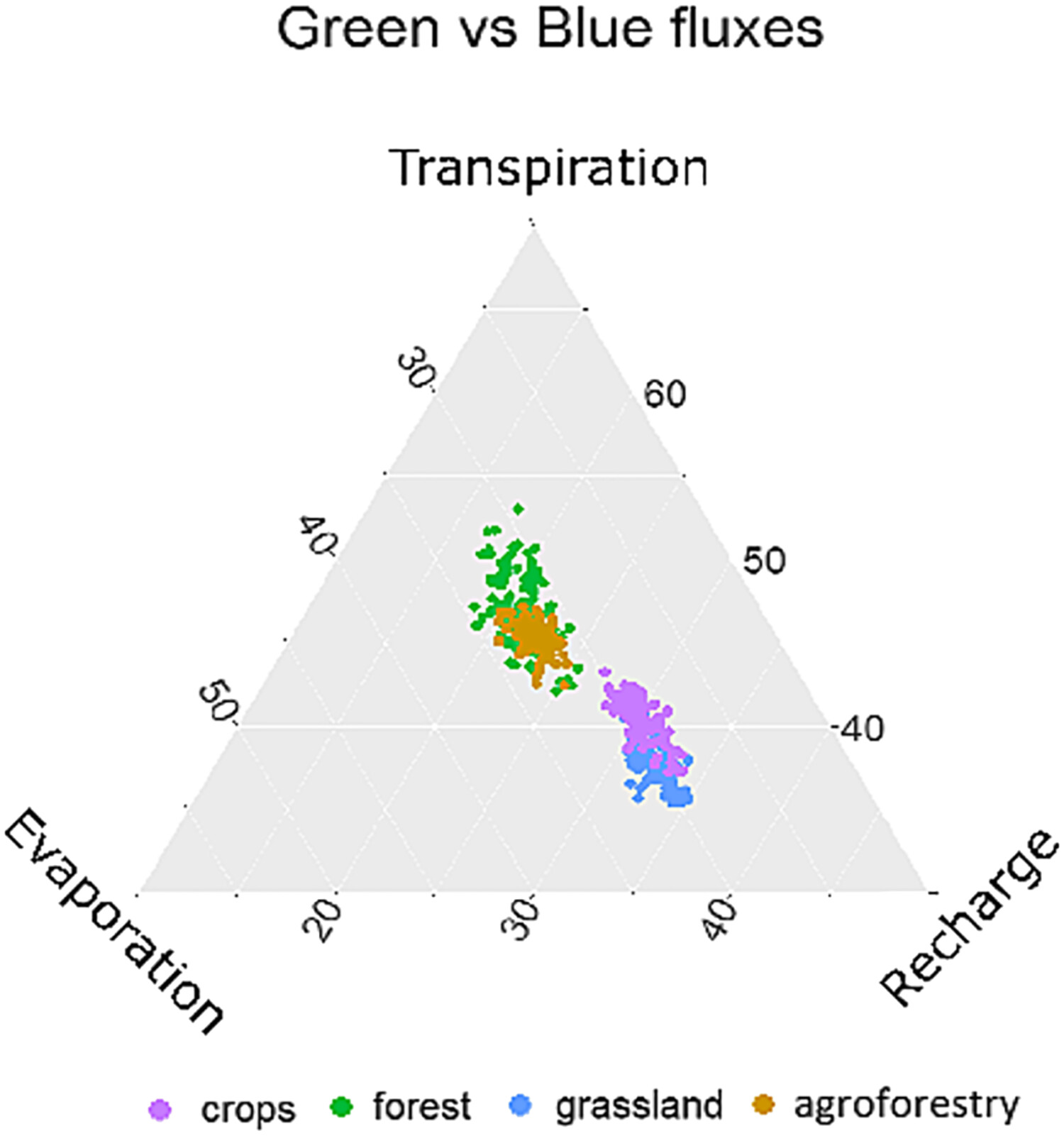
We implemented stable water isotopes into a parsimonious model to partition water fluxes in the critical zone. Green water fluxes were highest at forest, and blue water fluxes were highest at grassland. Our study illustrated the potential of stable water isotope data to contribute to simplified ecohydrological modelling and identifying model consistency.
Dynamics of run-off hydraulic characteristics during gully headcut erosion driven by head height
- First Published: 19 October 2023
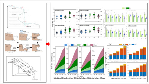
Gully headcut erosion is a compositional cyclic process dominated by mixed hydraulic and gravity erosion. Hydraulic properties change with the erosion process, which in turn affects sediment deposition processes throughout the system.Therefore, the effect of five different gully headcut heights (25–125 cm) on the hydrodynamic properties and energy consumption characteristics was investigated.
Morphological and structural characteristics of preferential flow and its influencing factors on colluvial deposits of Benggang
- First Published: 20 May 2024
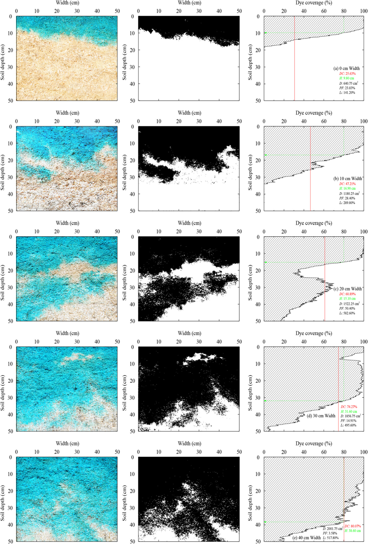
The dyed morphological parameters confirmed the existence of preferential flow through colluvial deposits. The development of preferential flow was closely related to the deposit accumulation time. Soil particle composition (gravel content in particular) has the greatest influence on the formation of colluvium preferential flow.
Iron pools of the typical loess–palaeosol sequence and their environmental significance in northeastern China
- First Published: 11 October 2023
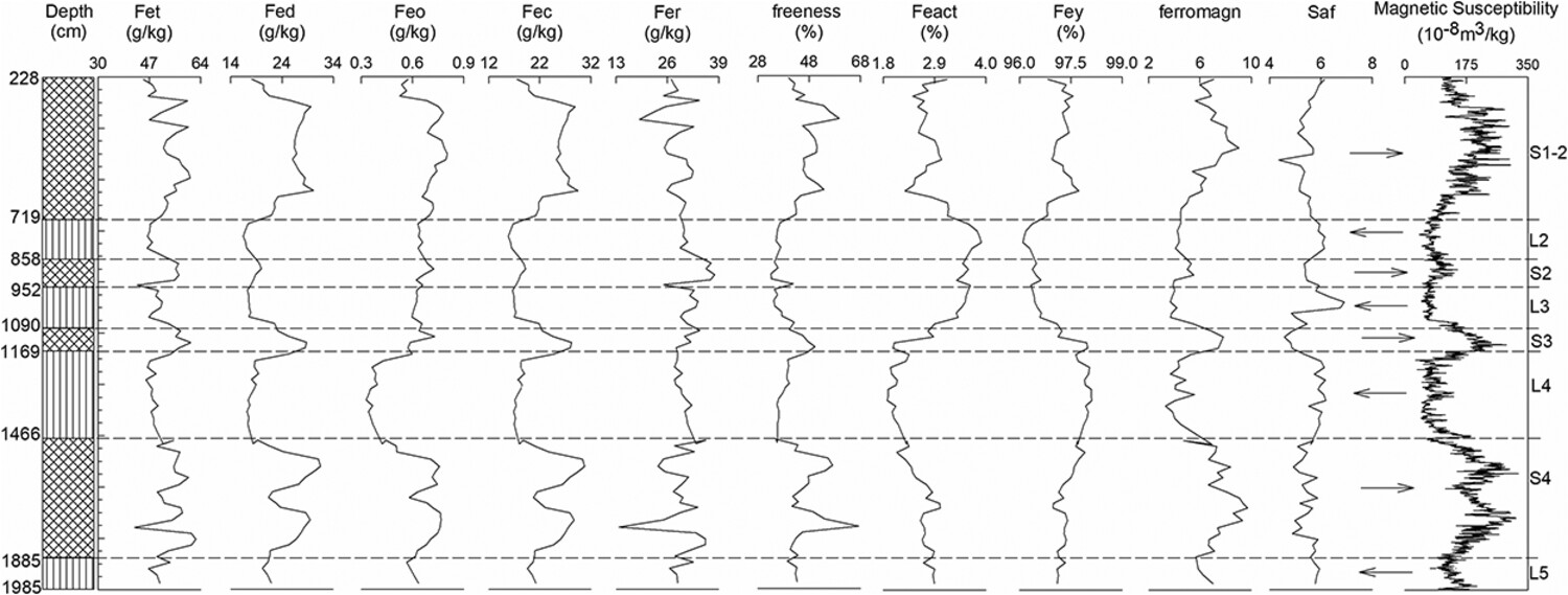
Loess–paleosol sequences display records of past climate events. Neoformation of iron oxides was closely related to pedogenesis degree. More crystalline Fe oxides were found in soils corresponding to warm interglacial periods. We detected many variations in abundance of Fe pools characterizing climate fluctuations that occurred in a short period of time. We demonstrated that measurements of Fe pools with dating techniques, morphological development indices, and magnetic susceptibility can be useful for tracing iron evolution in the Earth's critical zone.
Sign up for email alerts
Tools
More from this journal
- Award Winners
- Special Issues
- State of Science
- Call for Papers - Special Issue: The geomorphic signature of marine and continental Quaternary deposits
- Call for Papers - Special Issue: Earth surface processes and climate change at the Earth’s three poles
- Call for Papers - Special Issue: Novel approaches to quantify landscape changes (Cuchlaine King Symposium 2023)
- Call for Papers - Special Issue: Extreme Events in Geomorphology (Cuchlaine King Symposium 2024)
- Call for Papers - Special Issue: Applications of Artificial Intelligence in Geomorphology
- Call for Papers - Special Issue: Influence of tectonics and climate on landscape evolution: process and modelling
- Call for Papers - Special Issue: Fluvial processes and landforms in the Tibetan plateau in a period of rapid climate change
- Call for Papers - Special Issue: Wood in World Rivers 5
- Call for Papers - Spatial and temporal evolution of landslides induced by global climate change
- Call for Papers - Earth-Surface Processes in the Anthropocene: Human Impact, Climate Change, and Geomorphological Responses
- ESEX Commentaries
- BACKFILES An Online Archive from 1976 to 1995
- Other Resources
Latest Virtual Special Issues:
Is there a geomorphological case for the Anthropocene?
Chaired by Stephen Tooth, with panellists Professor Tony Brown, Simon Price and Professor Andreas Lang. Are we in the Anthropocene and no longer in the Holocene? Has human activity integrated and changed natural processes? Have we created our own geological time period?