

Journal list menu

 Issue
IssueEarth Surface Processes and Landforms: Volume 50, Issue 7
1-1815 June 2025
Export Citations
Download PDFs
ISSUE INFORMATION
RESEARCH ARTICLE
Distributed estimation of surface sediment size in paraglacial and periglacial environments using drone photogrammetry
- Pages: 1-18
- First Published: 09 June 2025
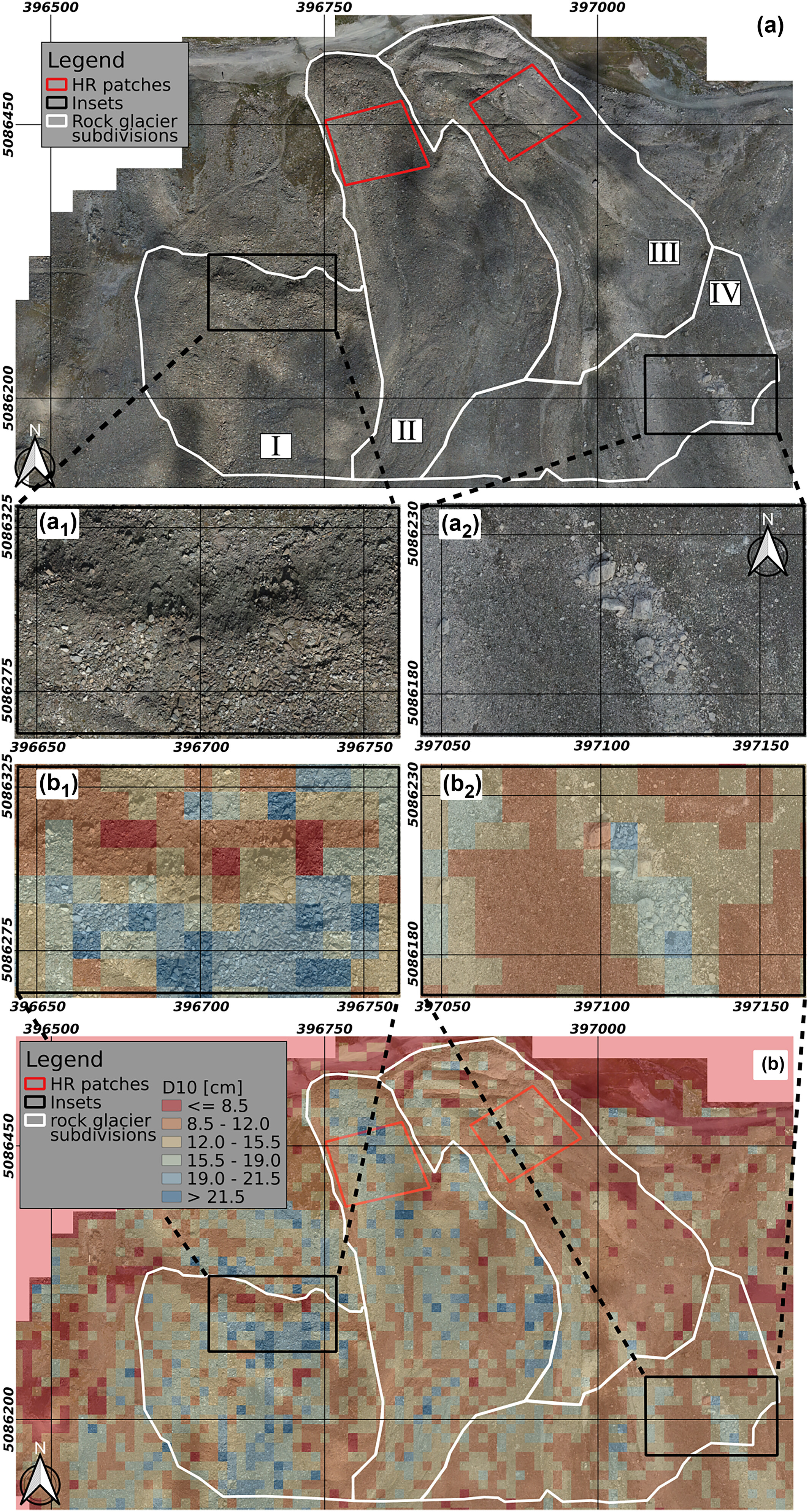
This study introduces a new workflow for estimating surface grain size in paraglacial and periglacial environments using drone photogrammetry and machine learning. Trained on Canadian alpine basins and validated on an Italian rock glacier, the model demonstrates high efficiency and accuracy, providing a new tool for studying these landscapes.
Long-term geomorphic response of a southwestern USA river following establishment and removal of an invasive riparian tree
- First Published: 04 June 2025
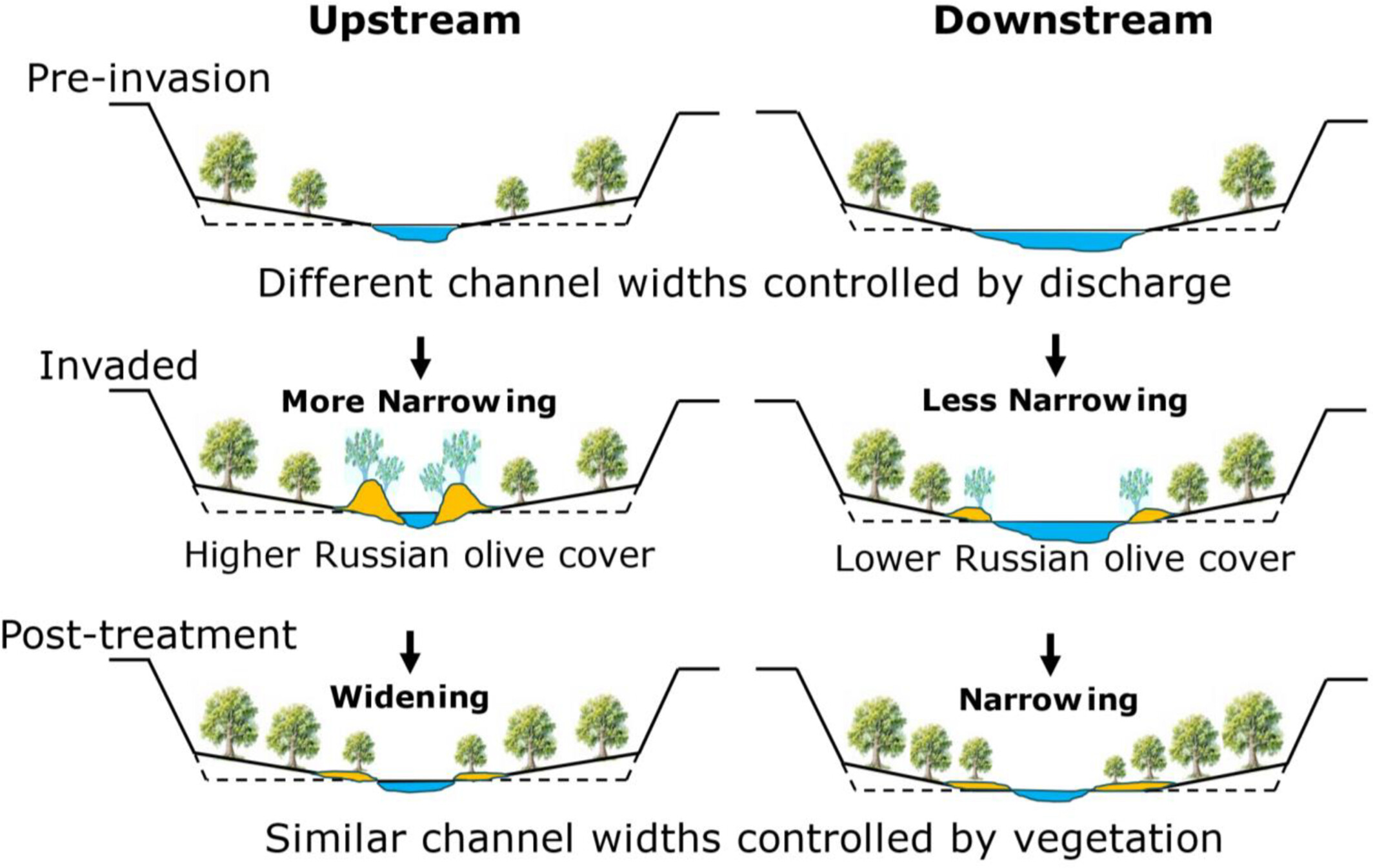
The invasion and treatment of Russian olive imposed distinctive geomorphic effects along the Escalante River, Utah, USA. Because this invasion was progressive and superimposed upon an on-going, multi-decadal channel narrowing involving native vegetation, resulting channel change was spatially and temporally complex with upstream to downstream differences in channel response.
Exploring sand ridge formation and preservation in a semi-enclosed tideless basin, Puck Bay, Baltic Sea
- First Published: 04 June 2025
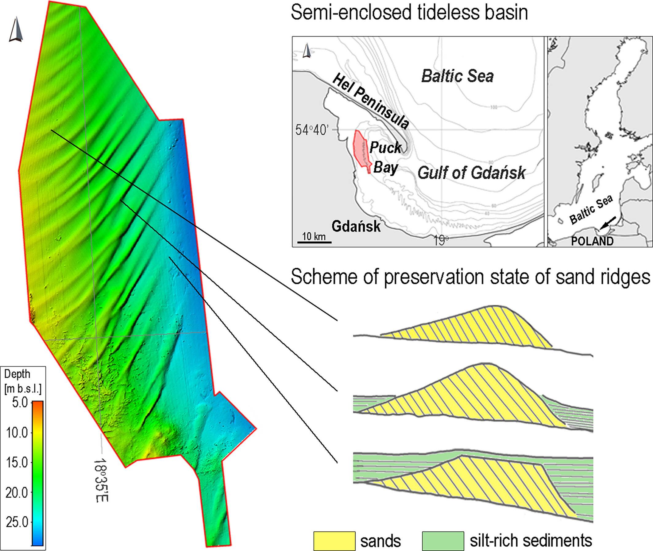
Sand ridges, typically found on tide- and storm-dominated shelves, are documented for the first time in a semi-enclosed bay of a non-tidal intra-continental sea. High-resolution hydroacoustic data reveal their morphology, internal structure and varying preservation states, providing new insights into their formation and evolution in the southern Baltic Sea.
Quantitative geomorphological analyses reveal late Cenozoic uneven tectonic expansion at the North Qilian Shan
- First Published: 03 June 2025
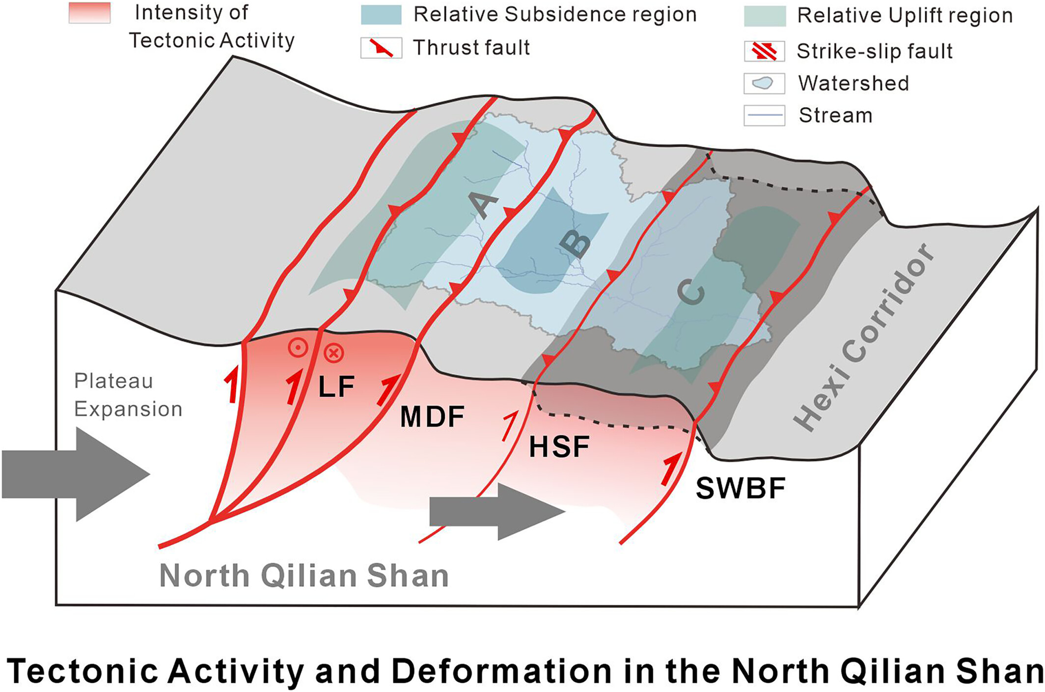
Quantitative geomorphology analyses reveal spatial variation in landscape characteristics across fault zones, suggesting differential fault activity and uneven uplift of geological units in the North Qilian Shan, providing new insights into the northeastern expansion of the Tibetan Plateau.
Drainage evolution in accretionary thrust systems as responses to tectono-climatic variability: Insights from sandbox modelling
- First Published: 04 June 2025
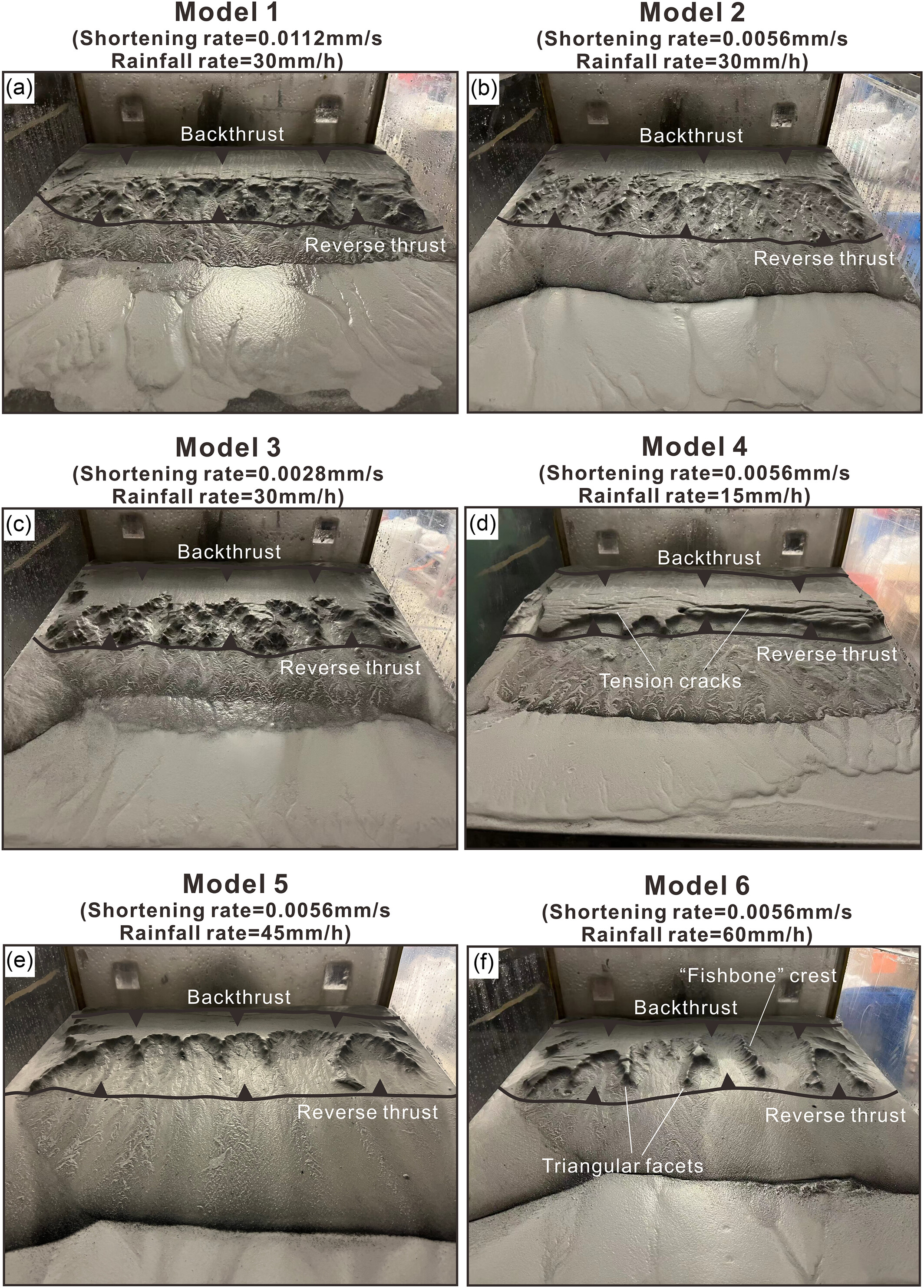
This study reveals the tectono-climatic coupling in orogenic evolution: ratio of shortening rate to rainfall rate (RSR) positively regulates drainage density; climate shifts erosion from lateral to headward dominance, while tectonics govern topography and climate modulates sedimentation, validated by natural systems like Longmen Shan.
Controls on geomorphological stage of trough blowout evolution: Evidence from computational fluid dynamics (CFD) airflow modelling
- First Published: 04 June 2025
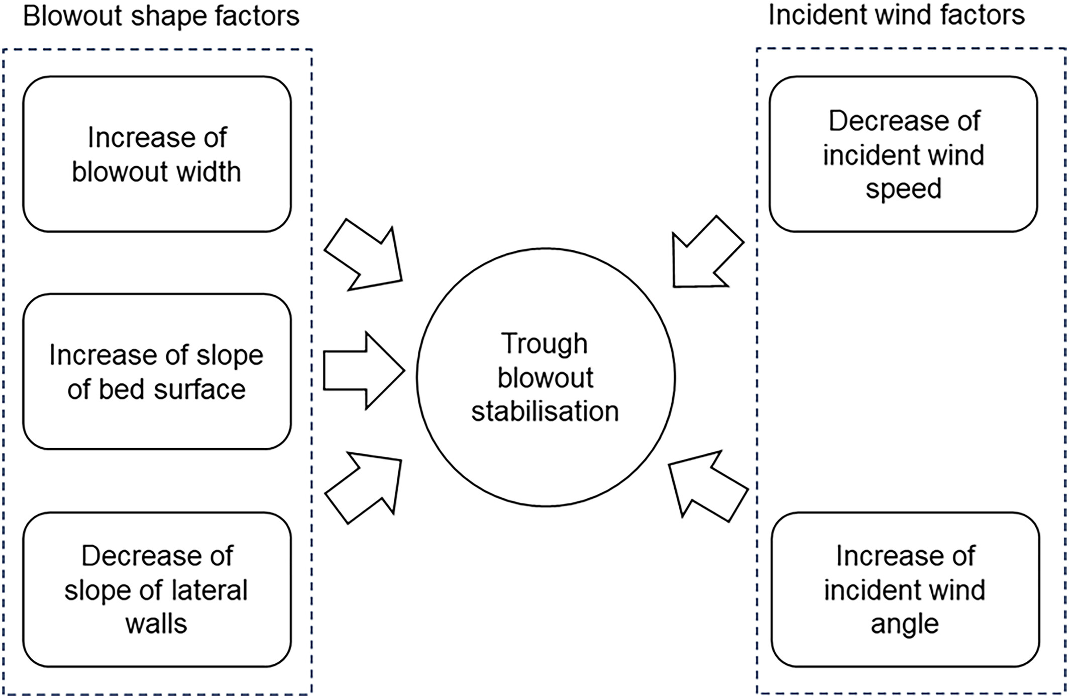
Increasing bed slope, decreasing wall slope, increasing blowout width, decreasing wind speed and increasing wind angle result in a decrease in average shear velocity on the lateral walls and bed surface of the blowout, which then facilitates blowout stabilisation.
Distribution and constructed morphology of artificial foredune notches
- First Published: 05 June 2025
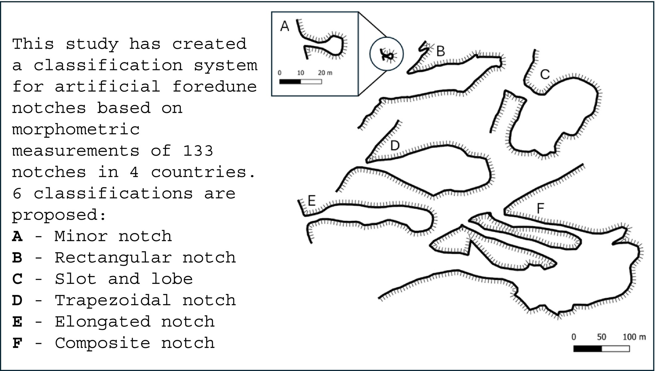
This study has identified constructed foredune notches and using aerial images created a classification system based on morphometric measurements of 133 notches in four countries. Six classifications are proposed: A—Minor notch, B—rectangular notch, C—slot and lobe, D—trapezoidal notch, E—elongated notch, and F—composite notch.
Investigating encroachment behaviour of pore water on pore structure of unsaturated loess using continuous NMR technique
- First Published: 04 June 2025
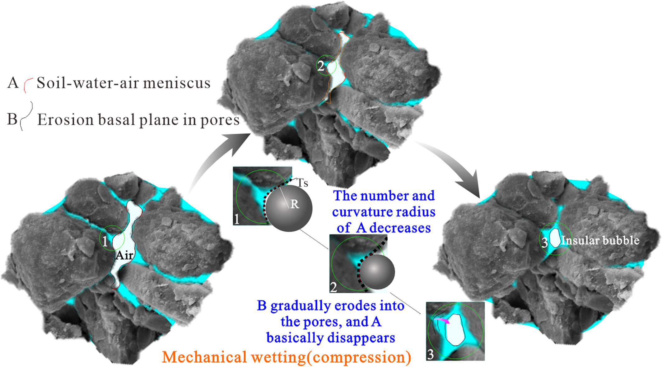
During mechanical wetting, the pore water gradually encroaches on the pore structure, which increases the debonding effect and the loess behaviour gradually converges to that of saturated loess. The compression of pore makes the increased saturation insufficient to offset the enhancement of capillary action, thus strengthening the water retention property.
Gravel bar shielding: A mechanism responsible for bar stability in gravel- and cobble-bedded streams
- First Published: 05 June 2025
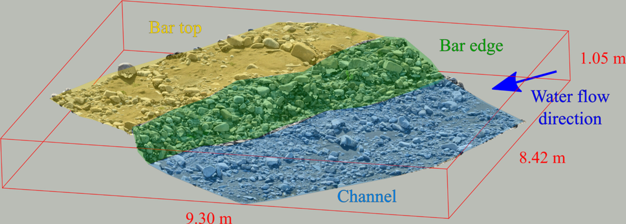
In this study, we demonstrate that coarse-grained bar edges, referred to as “lateral lag deposits”, play a key role in stabilizing non-vegetated gravel-cobble bars, particularly during lower-discharge flooding events. We also describe the morphology of these gravel-bar structures in a braided-wandering stream.
Comparing terrestrial laser scanner and ground-based structure from motion photogrammetry for urban sinkhole characterization and monitoring in Zaragoza, Spain
- First Published: 05 June 2025
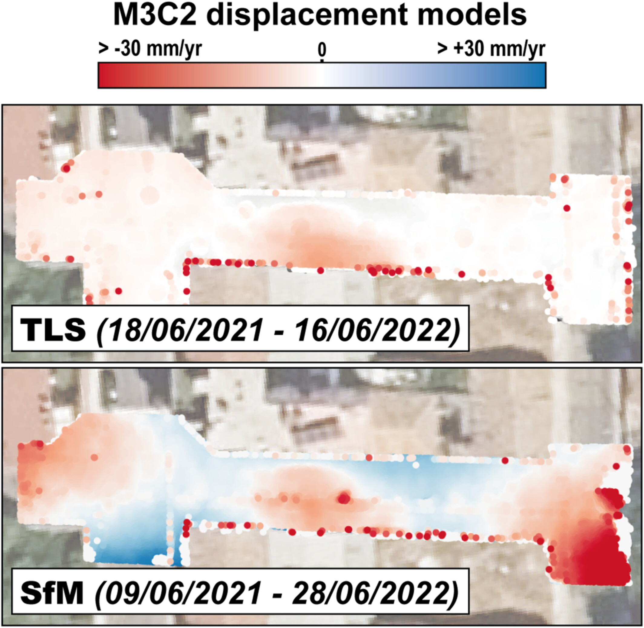
Despite TLS providing displacement data with less noise and internal distortion, SfM photogrammetry using ground-based cameras can achieve comparable performance for sinkhole characterization and monitoring in an urban area if accurate geodetic data are available. However, both techniques may underestimate the extent and rate of the deformation.
Provenance of Taklimakan Desert aeolian sediments based on rare earth elements signatures
- First Published: 05 June 2025
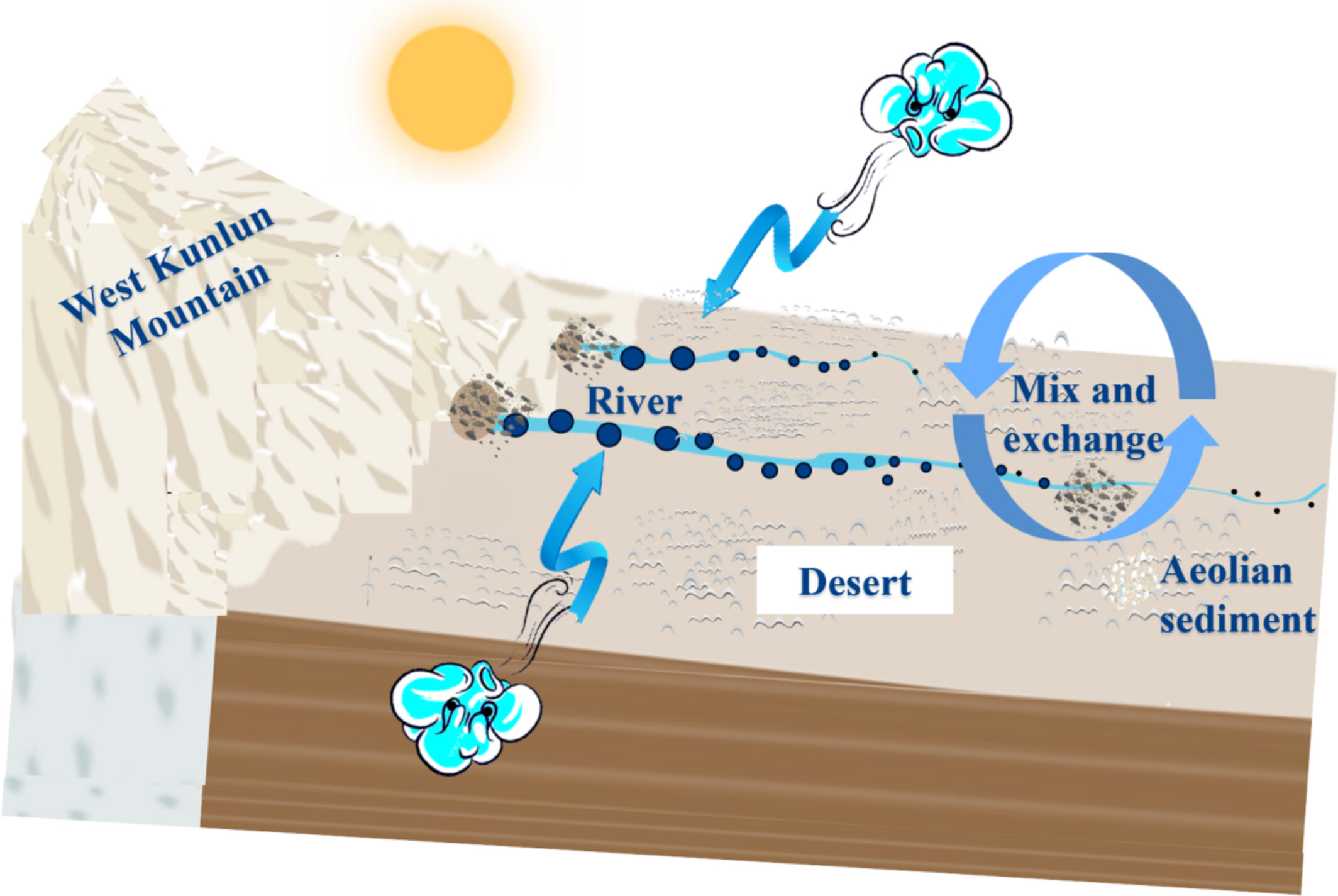
Rare earth elements show aeolian sediment in the Taklimakan Desert mainly comes from the West Kunlun Mountains, with similarity to desert due to river and wind regime.
Landscape evolution and aquifer building processes in a carbonate fold-and-thrust belt, Italian Southern Alps: Insights from 3D geo-modelling
- First Published: 08 June 2025
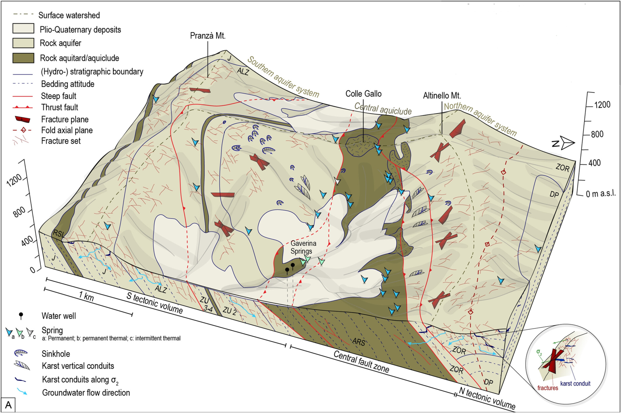
Landscapes of thrust belts coevolve with carbonate aquifers controlled by base-level dynamics linking surface-subsurface processes. Increments of Neogene uplift and slip rates, erosional unroofing, speleogenesis, exhumation of caves and origin of aquifers are recorded by landforms. 3D–4D geo-modelling of carbonate aquifers may be constrained to coevolution history of landscape and subsurface.
Observing the mass balance and emergence velocity of a temperate glacier on Mt. Yulong, southeastern Tibetan Plateau
- First Published: 09 June 2025
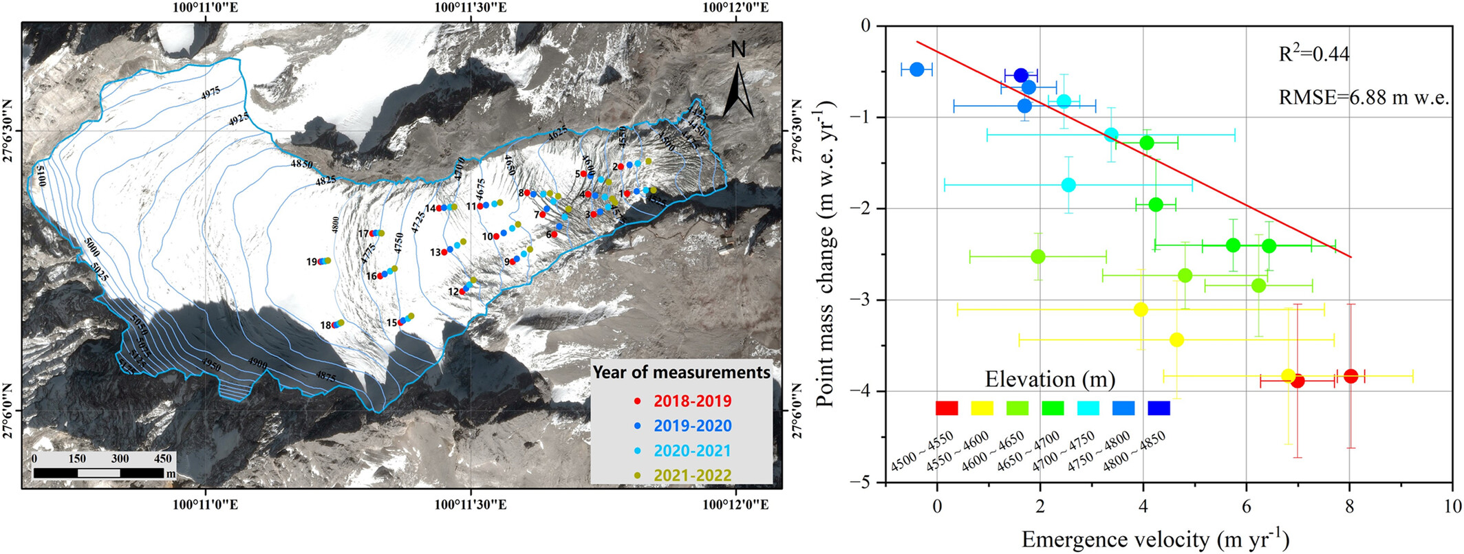
At Baishui River Glacier No. 1 in Yulong Snow Mountain, even if the horizontal and vertical velocities are accurately measured, the large uncertainties related to the slope changes prevent us from calculating the point surface mass change from the emergence velocity.
Detailed numerical simulation of landslide dam failure considering non-uniform and multi-layered sediments: A case study of the second Baige landslide dam in the Jinsha River, China
- First Published: 11 June 2025
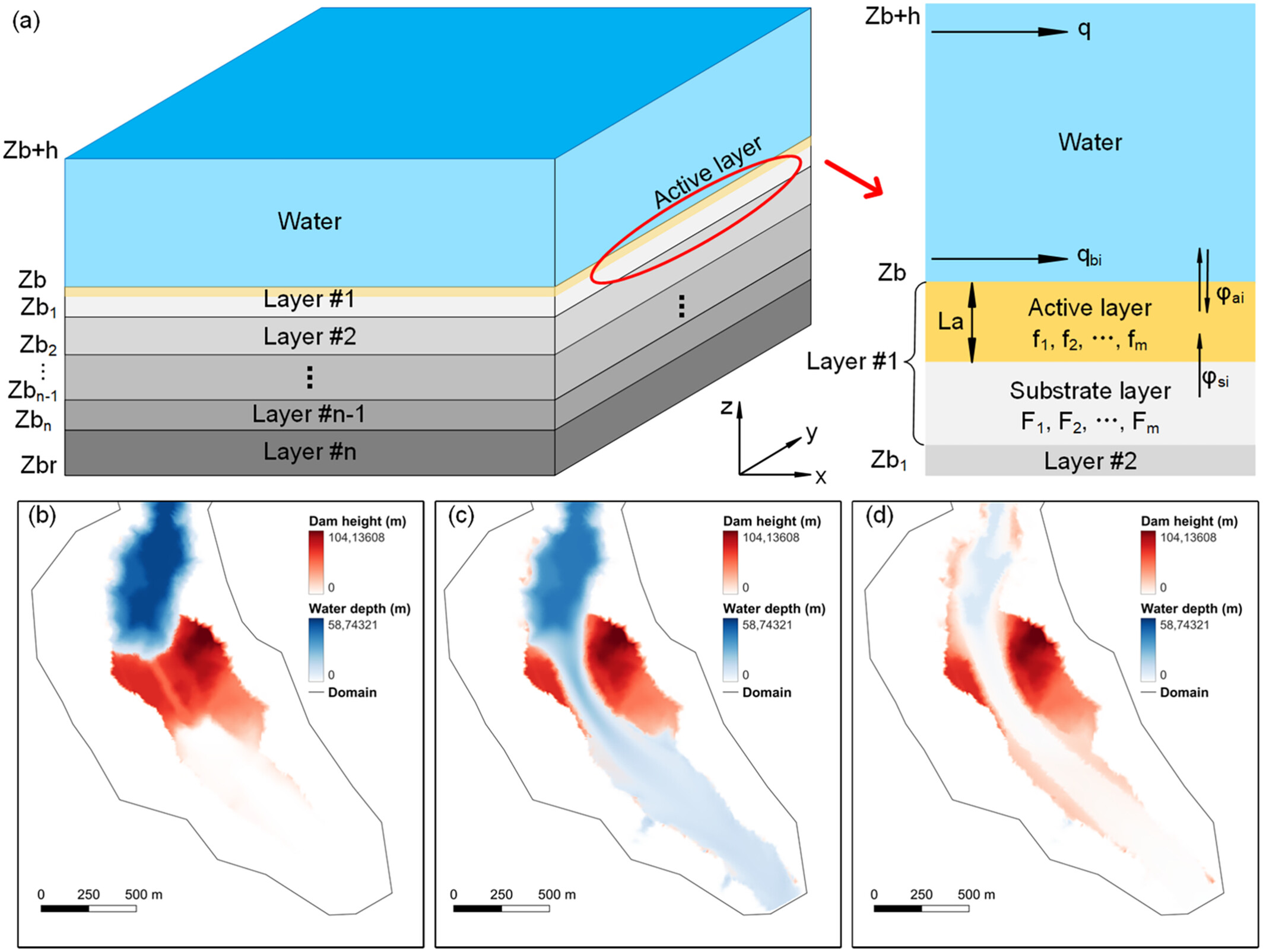
This study proposed a 2D numerical model considering multi-layered, non-uniform sediments to simulate the failure of the second Baige landslide dam. The effects of upstream inflow and dam material composition are investigated. The model outperformed empirical and simplified approaches, providing a more reliable simulation framework that aids to hazard management in mountainous regions.
Sign up for email alerts
Tools
More from this journal
- Award Winners
- Special Issues
- State of Science
- Call for Papers - Special Issue: The geomorphic signature of marine and continental Quaternary deposits
- Call for Papers - Special Issue: Earth surface processes and climate change at the Earth’s three poles
- Call for Papers - Special Issue: Novel approaches to quantify landscape changes (Cuchlaine King Symposium 2023)
- Call for Papers - Special Issue: Extreme Events in Geomorphology (Cuchlaine King Symposium 2024)
- Call for Papers - Special Issue: Applications of Artificial Intelligence in Geomorphology
- Call for Papers - Special Issue: Influence of tectonics and climate on landscape evolution: process and modelling
- Call for Papers - Special Issue: Fluvial processes and landforms in the Tibetan plateau in a period of rapid climate change
- Call for Papers - Special Issue: Wood in World Rivers 5
- Call for Papers - Spatial and temporal evolution of landslides induced by global climate change
- Call for Papers - Earth-Surface Processes in the Anthropocene: Human Impact, Climate Change, and Geomorphological Responses
- ESEX Commentaries
- BACKFILES An Online Archive from 1976 to 1995
- Other Resources
Latest Virtual Special Issues:
Is there a geomorphological case for the Anthropocene?
Chaired by Stephen Tooth, with panellists Professor Tony Brown, Simon Price and Professor Andreas Lang. Are we in the Anthropocene and no longer in the Holocene? Has human activity integrated and changed natural processes? Have we created our own geological time period?