

Journal list menu

 Issue
IssueEarth Surface Processes and Landforms: Volume 49, Issue 1
1-508January 2024
Export Citations
Download PDFs
ISSUE INFORMATION
ESEX COMMENTARIES
Editorial 2024: Large language models, artificial intelligence and geomorphology
- Pages: 3-9
- First Published: 21 January 2024
New Zealand's braided rivers: The land the law forgot
- Pages: 10-14
- First Published: 20 November 2023
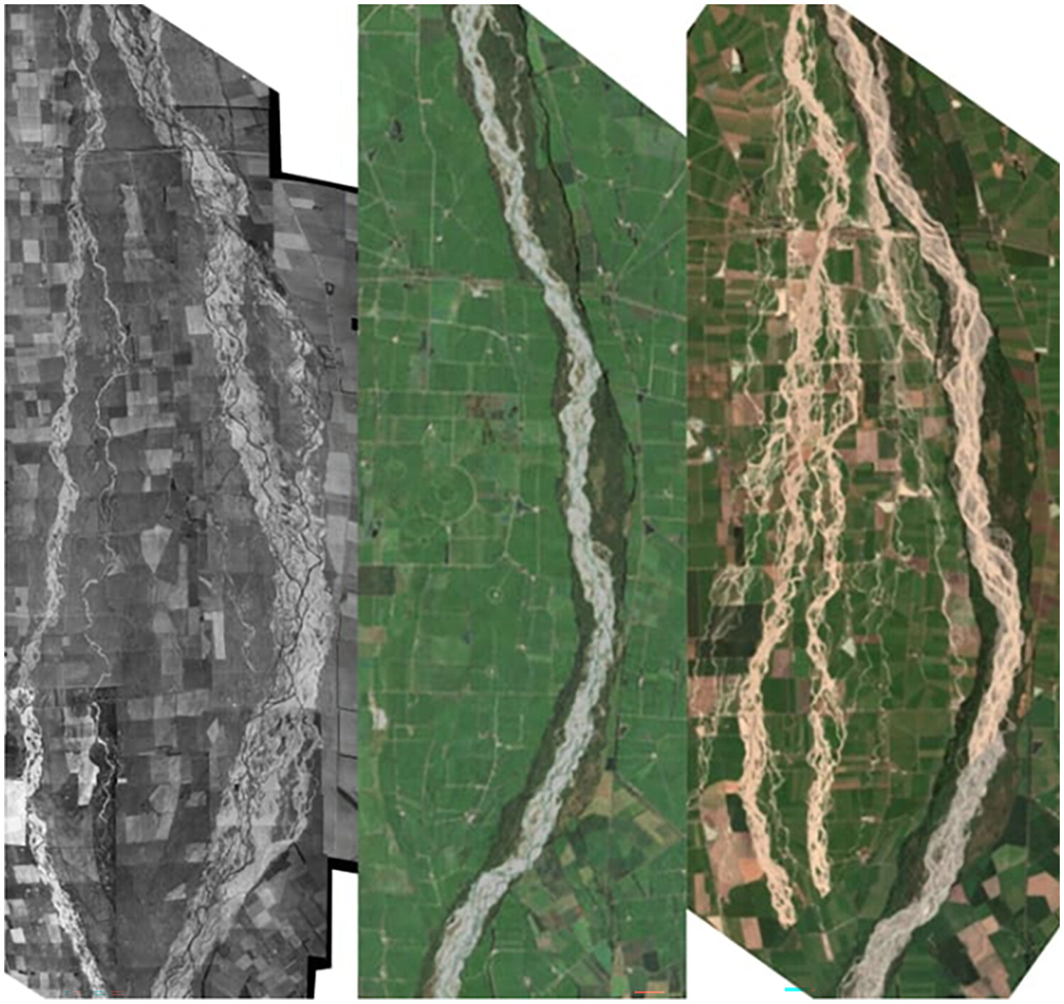
New Zealand's Rangitata River, the same reach at 3 different dates: 1937 (on the left), 2016-2018 (in the middle), and after floods in 2019 (right). The river reverts to its former course at flood stage, expanding beyond its narrowed margins (Source: Brierley et al., 2023)
LETTERS TO ESEX
Global mapping of river sediment bars
- Pages: 15-23
- First Published: 01 November 2023
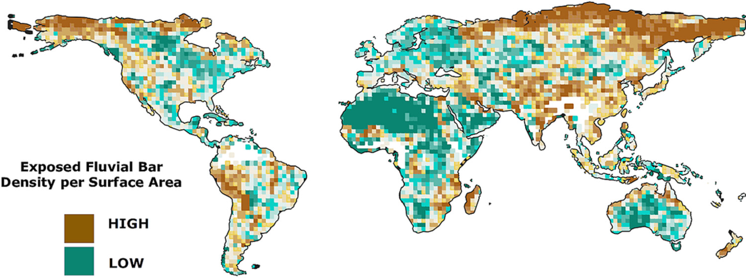
We present the first global scale inventory of fluvial bars based on Sentinel-2 imagery processed at a spatial resolution of 10 m with a deep learning and image processing workflow. We count 8.9 million gravel bars with an estimated area of 41 000 km2.
STATE OF SCIENCE
Examining the commonalities and knowledge gaps in coastal zone vegetation simulation models
- Pages: 24-48
- First Published: 16 February 2023
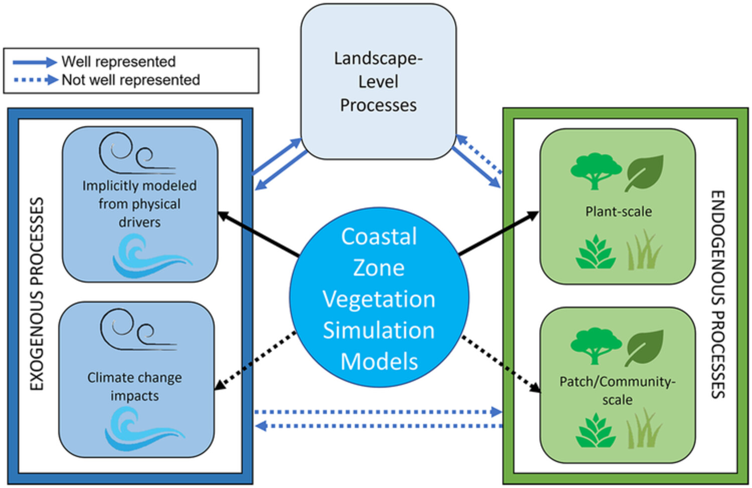
Of the fifty-four coastal zone vegetation models reviewed, most were narrowly defined based on the system of interest and focused on plant-scale processes that predicted aboveground biomass growth rather than patch and community-scale processes such as competition. Most models have limited ability to simulate vegetation dynamics associated with climate change and management actions. Future models should adopt process-based approaches that explicitly account for both biotic and abiotic factors to better capture vegetation response to changes in environmental conditions.
Achieving change through gully erosion research
- Pages: 49-57
- First Published: 21 March 2023
Following the 8th International Symposium on Gully Erosion we propose an increased focus on research impact on gully management and prevention, by defining the consequences of gully erosion, enhancing collaboration, focusing on use by practitioners, and expanding monitoring and evaluation.
Remote sensing of laboratory rivers
- Pages: 58-81
- First Published: 18 March 2023
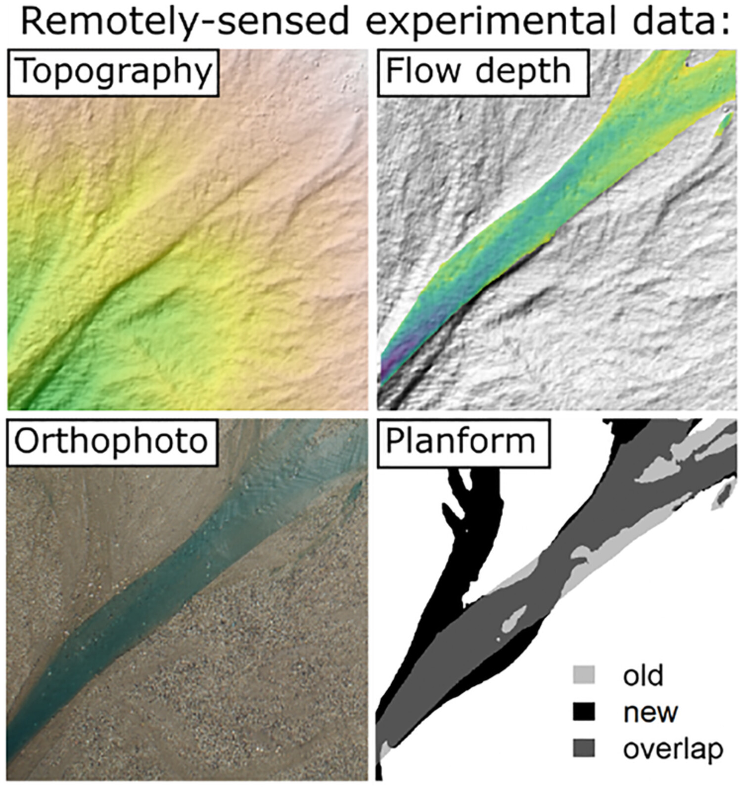
Remote sensing can be adapted for the lab to monitor the evolution of physical experiments without disrupting their processes. We review ways to deploy ‘remote sensing’ for experiments in fluvial geomorphology. We hope this paper will be helpful for experimentalists who want to collect data both continuously and cost-effectively.
Gullies and badlands of India: Genesis, geomorphology and land management
- Pages: 82-107
- First Published: 22 March 2023
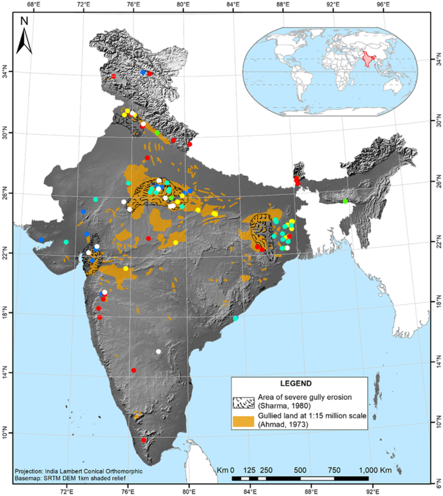
- Studies on gully formation (red dots on map), badlands genesis (blue dots), gully and badlands mapping (aquamarine dots), their geomorphology (yellow dots), effects (green dots) and gully/badlands management (white dots) in India are discussed.
- While gully formation has largely been anthropogenically induced in India, her badlands have formed naturally in response to neotectonics and Holocene climate change.
- Morphologies of gullies and badlands vary prominently across the country, and they have been mapped and measured using a variety of methodological approaches, ranging from manual mapping, field surveys to semi-automatic approaches like machine learning.
- Gully erosion effects have been investigated across the country, though sporadically, but land management interventions have overwhelmingly been implemented in the badlands of Central and Western India.
Contemporary research in coastal dunes and aeolian processes
- Pages: 108-116
- First Published: 09 April 2023
Novel methodological advances in coastal dune and aeolian process research include holographic camera systems, sediment samplers, uncrewed aerial vehicles (drones), and photography-based sediment tracing. Large-scale studies of coastal dune mobility are an excellent reminder that dunes respond quickly to natural and/or human pressures and comprise part of the wider nearshore–beach–dune continuum. Conflicting dune management practices can equally perceive bare sand as good and/or bad; migrating dunes as good and/or bad; and fully vegetated, stable dunes as good and/or bad.
Parabolic dune distribution, morphology and activity during the last 20 000 years: A global overview
- Pages: 117-146
- First Published: 09 June 2023
Parabolic dunes are ubiquitous on Earth and are particularly sensitive to climate changes. This global review presents a valuable database for predicting their future development. It shows that global atmospheric circulation governed their morphology and migration direction, thus aiding predictions and providing insights into paleoclimate conditions. Although aridification has triggered past dune activity during both warm and cold periods, recent activity is mostly linked with human disturbances, highlighting the need for management programs also in humid geographic zones.
Bedload tracing with RFID tags in gravel-bed rivers: Review and meta-analysis after 20 years of field and laboratory experiments
- Pages: 147-169
- First Published: 12 September 2023
A review of field and laboratory radio frequency identification (RFID) bedload tracing experiments is proposed, including a meta-analysis of data coming from 459 tracer surveys for a total of 125 study sites. RFID tracers open new avenues for exploring fluvial environments prone to rapid bedload dispersion. The most recent methodological developments based on active ultra-high frequency RFID tags show that it is now possible to conduct efficient bedload tracing experiments not only in small streams but also in large gravel-bed rivers or active braided channels.
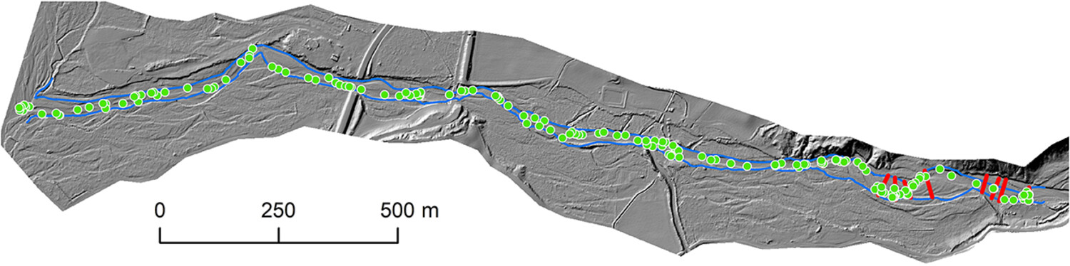
Conceptual model for the formation of bedforms along subglacial meltwater corridors (SMCs) by variable ice-water-bed interactions
- Pages: 170-196
- First Published: 20 October 2023
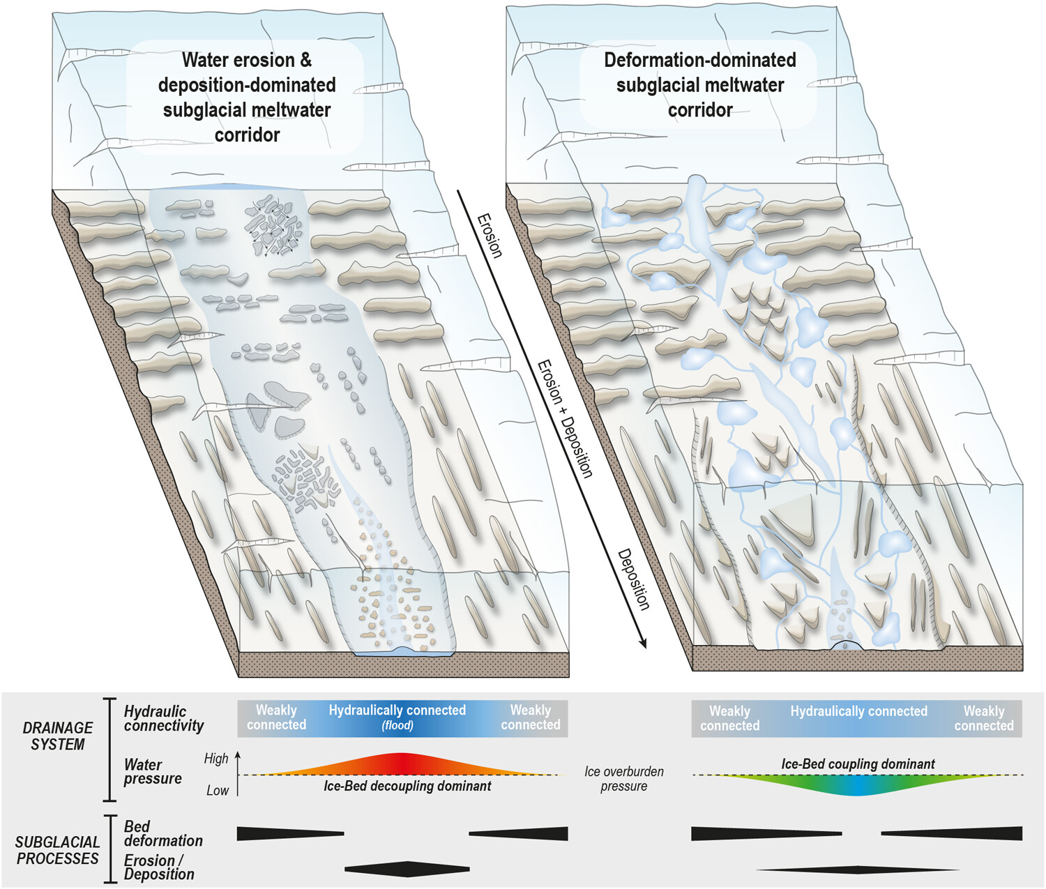
Subglacial meltwater corridors (SMCs), corresponding to the geomorphological footprints of subglacial drainage routes, are populated by a variety of subglacial bedforms. In this study, we compile existing and new observations on SMC bedforms to identify typical bedform assemblages (i.e. tracts). We then propose a model where spatiotemporal changes in hydraulic connectivity, meltwater pressure and ice-bed coupling influence the evolution of subglacial processes, either dominated by bed deformation or by water erosion and deposition, along SMCs.
Revisiting the geomorphological-biological divide: An introspective biogeomorphological perspective
- Pages: 197-209
- First Published: 03 November 2023
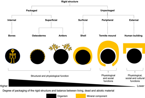
Biomineralized structures, such as bones or shells that are packaged within the organism or at the periphery of the organism, and extended products of genes, such as termite mounds that are unpackaged outside the organism, form a continuum of variation in relative dominance and functional integration of biotic and abiotic components. We revisit the basic premises of biogeomorphology with the proposition that the clear dichotomy geomorphologists and biologists traditionally establish between living and non-living components of biogeomorphological entities may be too limiting.
Recognizing the ephemeral stream floodplain: Identification and importance of flood zones in drylands
- Pages: 210-235
- First Published: 15 December 2023
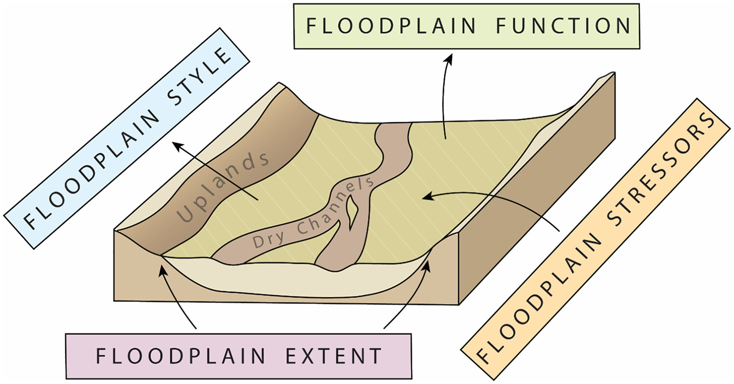
Floodplains in ephemeral stream corridors share temporary inundation with dry channels, yet variations in hydrologic, geomorphic and biotic characteristics lead to unique functions in overbank areas. Based on a synthesis of the prior literature, definitions of the floodplain boundary and extent were revisited, and distinct floodplain styles were identified. Ephemeral stream floodplains host hydrologic, geomorphic and biotic functions unique from the channel and uplands, which could be altered by future climate change, land use change or other anthropogenic stressors.
The fault in our TARs: A critical review of research paradigms for intermediate-scale bedforms on Mars
- Pages: 236-255
- First Published: 21 December 2023
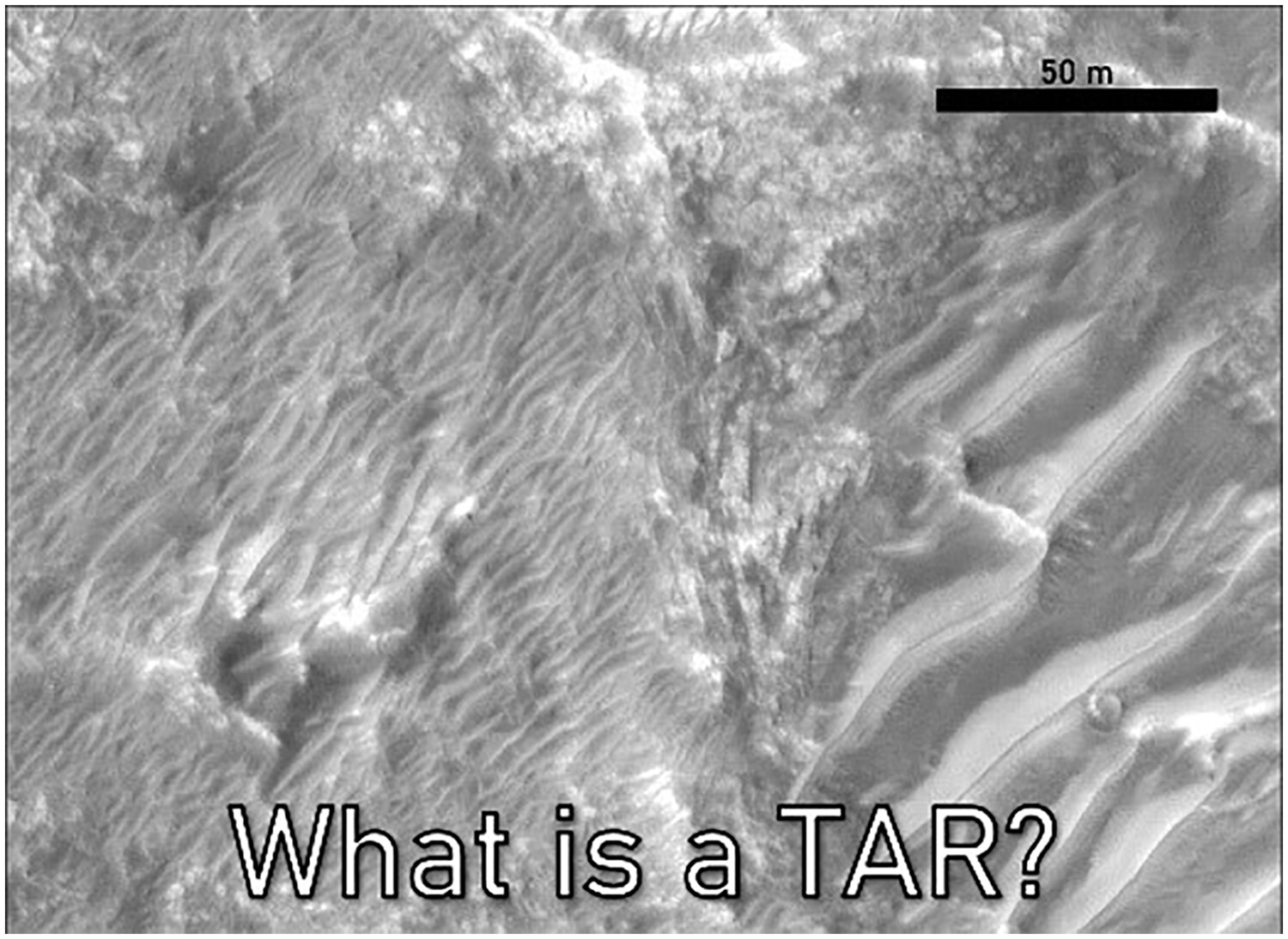
This work interrogates the literature on intermediate-scale Martian aeolian bedforms to enquire why terminology in this field has become more complex than aeolian research on Earth. We find that this complexity has emerged from an inductive research paradigm that contrasts with conventional abductive research structures on Earth. Differences between the two are addressed, and it is recommended that research simply cease using placeholder terms like ‘transverse aeolian ridge’ and ‘large Martian ripple’ to realign terrestrial and planetary research paradigms.
STATE OF THE SCIENCE
Current progress in quantifying and monitoring instream large wood supply and transfer in rivers
- Pages: 256-276
- First Published: 05 February 2024
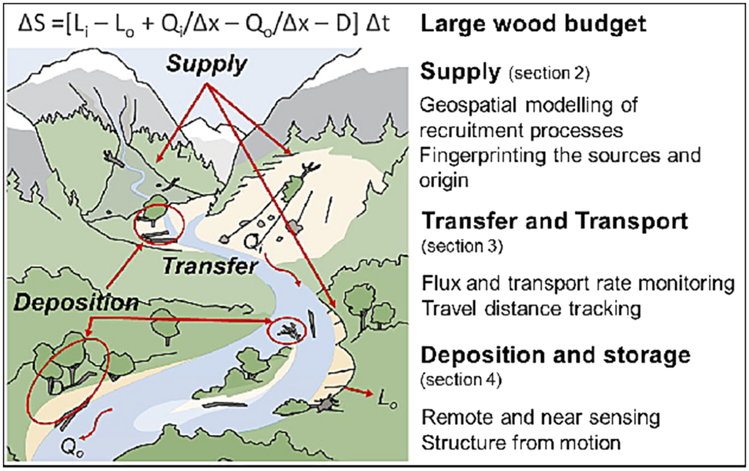
Large wood plays a crucial role in the form and function of gravel-bed rivers, controlling their physical and ecological integrity. However, large quantities of wood transported during floods can pose hazards, potentially damaging infrastructures. The instream wood regime, or budgeting, describes the cascading processes from supply to deposition, transport, and decay. We review recent advances in quantifying these components, such as wood supply and transfer, made through biogeochemistry, videography, artificial intelligence, and tracking.
RESEARCH ARTICLES
Human impacts on infilling rates of hollows in landslide-prone areas of western Japan: Estimation from radiocarbon dates and high-resolution DEMs
- Pages: 277-290
- First Published: 02 August 2023
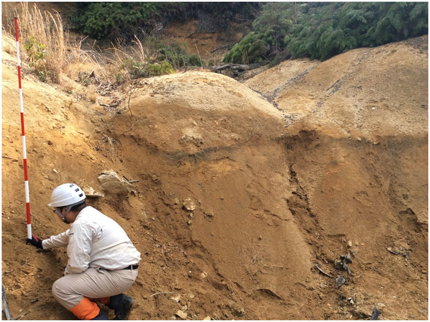
Infilling rates in hollows were inferred from the calibrated radiocarbon ages of buried charcoal and pre-landslide soil depth estimated from the LIDAR digital elevation model (DEM). Infilling rates were extremely high at two hollows with intensive human impacts from the 17th to the early 20th century. In two hollows with limited human impacts, infilling rates tended to increase with increasing topographic curvature.
Soil erosion and nutrient loss due to changes in rainfall intensity under different wind directions
- Pages: 291-303
- First Published: 01 August 2023
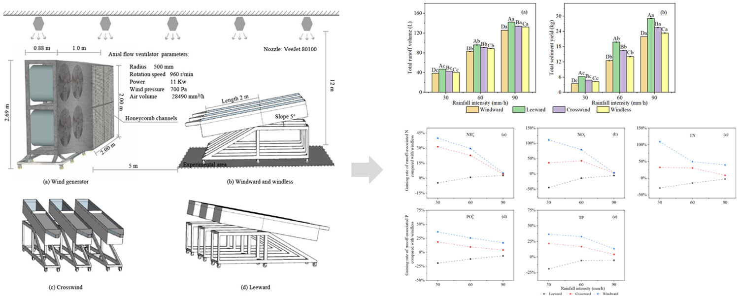
Response of soil erosion and nutrient loss on different wind directions in laboratory flume experiments.
A novel QLattice-based whitening machine learning model of landslide susceptibility mapping
- Pages: 304-317
- First Published: 06 August 2023
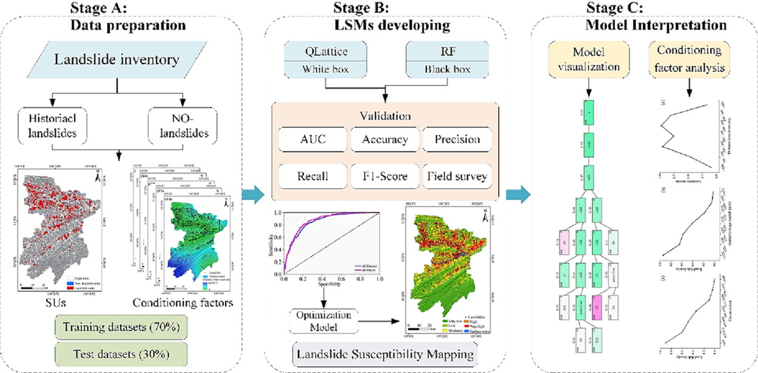
Based on landslide inventory, historical landslides, and nonlandslides that are distinguished, train and test sets are divided into 7:3 (Stage A). An LSM model is constructed based on two algorithms, QLattice and RF, and evaluated based on indicators such as AUC, obtaining the optimal model for landslide prediction in the study area (Stage B). Stage C visualized the model and analysed the conditioning factors.
Asymmetric evolution of river mouth bifurcation under angled river-tide interaction, a case study at river mouths of Lingding Bay, Pearl River estuary
- Pages: 318-333
- First Published: 11 September 2023

- High tidal discharge tends to increase residual sediment transport and tide-induced erosion in the low-angle channel.
- Low tidal discharges facilitate fluvial-induced bifurcation.
- The conceptual model applies to river mouth channels where suspended sediment transport is dominant and influenced by angled incoming tides.
Magnitude and timing of transient incision resulting from large-scale drainage capture, Sutlej River, Northwest Himalaya
- Pages: 334-353
- First Published: 12 September 2023
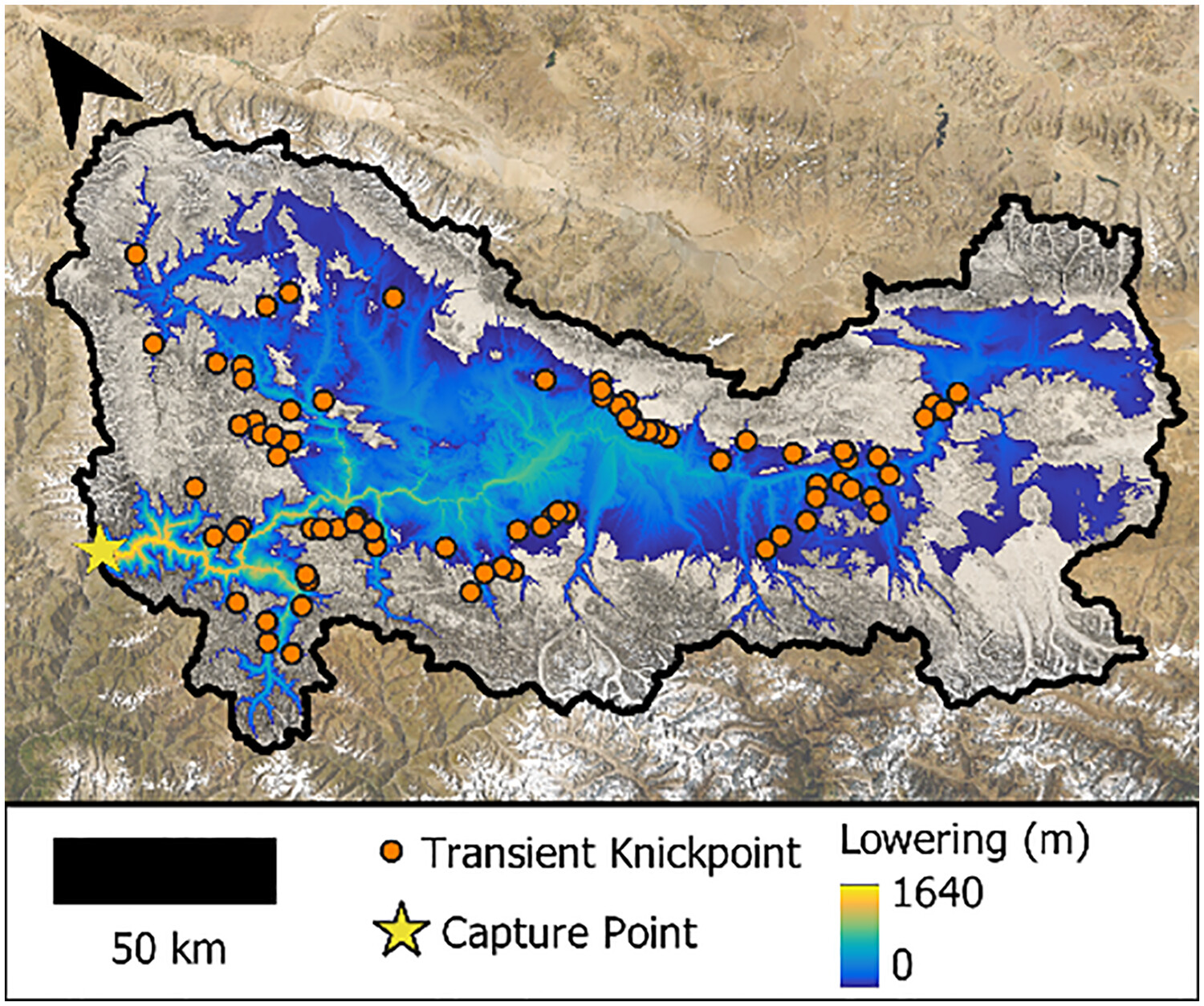
Few studies have constrained the magnitudes and timescales associated with large-scale drainage captures (areas >103 km2). In this study, find that large-scale capture of the Zhada Basin has increased sediment supply to the Himalayan Sutlej River by 17%–29% since capture (735 ± 269 ka). We identify several tectonic or autogenic mechanisms that may have facilitated capture of and provide a framework to assess potential mechanical links between arc-parallel extension, large-scale drainage capture, orogenic wedge deformation and buffering of environmental signals.
The heterogeneous geomorphological impact of an exceptional flood event and the role of floodplain vegetation
- Pages: 354-373
- First Published: 19 September 2023
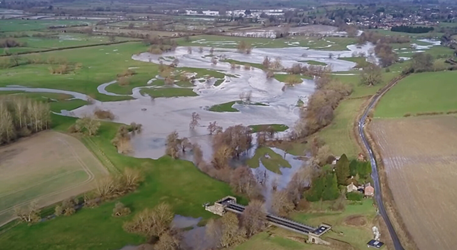
An integrated remote sensing assessment of in-channel pattern development, incision and aggradation; lateral bank migration; and overbank sedimentation and scour by out-of-channel flows highlighted that that spatial impacts from such extreme events are highly localised, varied in kind. The approach determined the role of continuous riparian vegetation in maintaining bank stability but also to the potential influence of floodplain vegetation and planting for ‘natural engineering’ in the context of floodplains as well as channels.
Grain size estimation in fluvial gravel bars using uncrewed aerial vehicles: A comparison between methods based on imagery and topography
- Pages: 374-392
- First Published: 21 September 2023
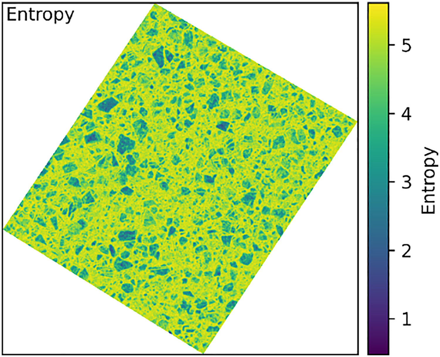
Grain size proxies based on image texture and topographic roughness were computed from drone surveys of fluvial gravel bars. Proxies based on image texture better estimated grain sizes than did those based on topographic roughness.
Determination of the maximum run-off sediment transport capacity during a rainstorm flood in a small watershed on the Loess Plateau
- Pages: 393-404
- First Published: 27 September 2023
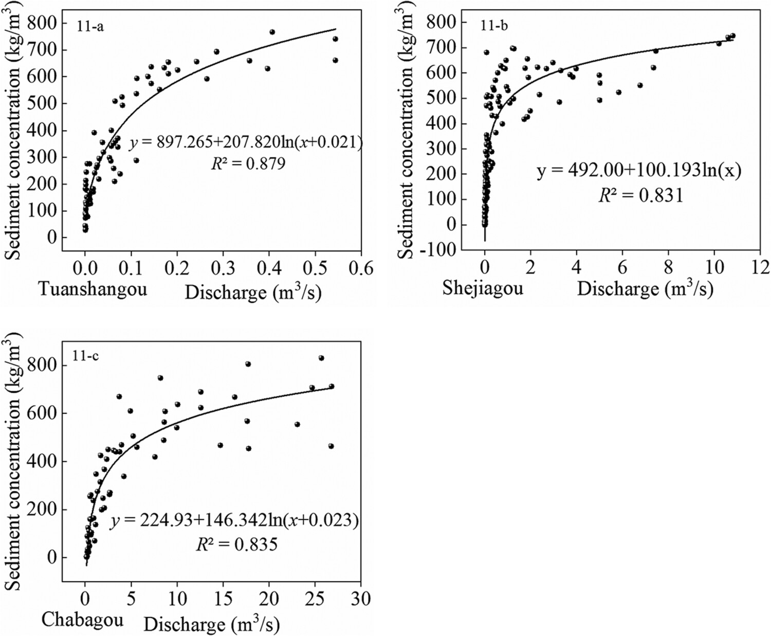
In the counterclockwise hysteresis, the sediment concentration in the sediment fall section may be sufficient. If the sediment source is sufficient, there should be a time-lagged effect due to energy consumption during the movement. As the function relationship between flow and sediment concentration progresses forward, its R2 will undergo a process of first increasing and then decreasing. The fitting relationship between sediment transport capacity and flow in the channel of the falling section is shown in the figure.
Evolution characteristics of mid-channel bars with a typical high/low bank structure in the Middle Yangtze River
- Pages: 405-416
- First Published: 02 October 2023
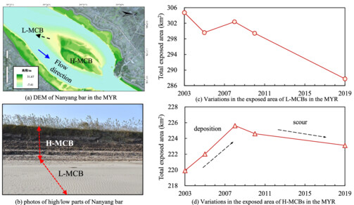
Differences in evolution characteristics between the L-MCBs and H-MCBs in the MYR were quantified. Impacts of both altered flow–sediment conditions and MCB's properties on the deformation of L-MCBs and H-MCBs were investigated.
Ecosystem engineering by periphyton in Alpine proglacial streams
- Pages: 417-431
- First Published: 03 October 2023
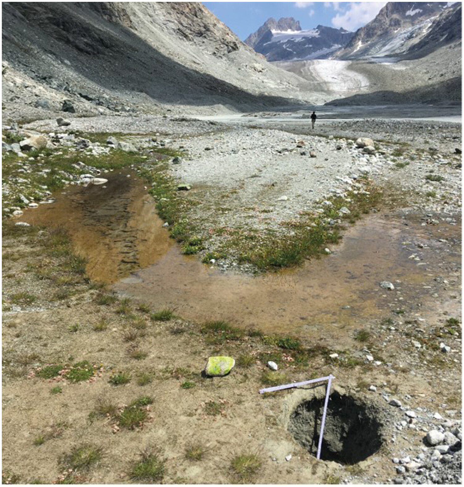
Stream periphytons are candidate ecosystem engineers in proglacial margins. We demonstrate that the development of periphyton reduces bed roughness and clogs the benthic interstice space, reducing vertical water infiltration. The changes in streambed roughness modify the near-bed turbulent structures, and this results in a reduction of adverse bursting events and in the modification of the turbulent kinetic energy at the near-bed layer.
Periglacial resurfacing of hillslopes and channels with large boulders in the Virginia Appalachians
- Pages: 432-450
- First Published: 08 October 2023
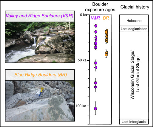
Cosmogenic 10Be exposure dating indicates that the depositional timing of large boulders in the Virginia Appalachians is between 10.8 ± 0.8 ka and 101.7 ± 6.9 ka. The correlation between measured boulder exposure ages and the Wisconsin Glacial Stage (~115–11.7) suggests a periglacial origin for the deposition of boulders. The absence of pre-Wisconsin ages suggests that periglacial hillslope processes allow the landscape to be resurfaced with large boulders during each return to cold climate conditions.
An advanced check-dam sedimentation module: Laboratory validation and implementation in a distributed sediment yield model for field application
- Pages: 451-467
- First Published: 11 October 2023
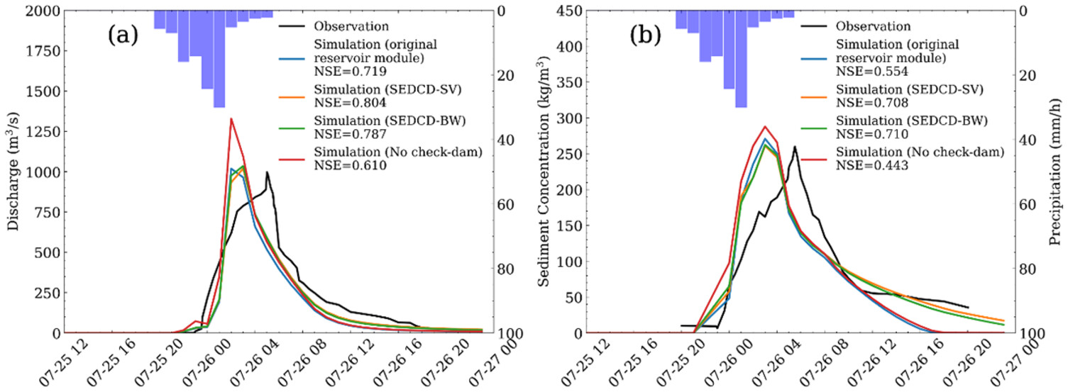
- Two versions (Saint–Venant and Backwater) of sediment trapping model for check-dam was established and validated against laboratory data with high accuracy of bed profiles.
- The model was incorporated in a distributed sediment yield model and was applicated to the Xiaoli River Basin with numerous check-dams. The hourly discharge and sediment concentration are simulated with high accuracy.
- The Backwater version model predicts sediment trapping with both good accuracy and high computational efficiency and thus is an advanced check-dam sedimentation module.
Karst landform classification considering surface flow characteristics derived from digital elevation models
- Pages: 468-481
- First Published: 03 October 2023
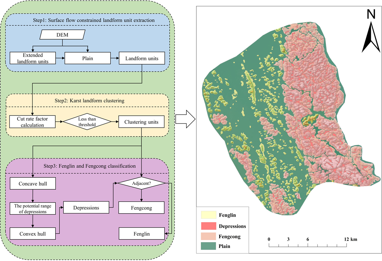
Karst landforms are one of the typical geographical units with a specific physical process on the earth's surface. In this study, we proposed a method considering surface flow for karst landform classification. The proposed approach is validated and applied in two sample karst areas, Fenglin and Fengcong, located in Guilin, China. The results demonstrated that the karst landform units of Fenglin and Fengcong can be effectively classified. The proposed method can be extended to other landform types with complex landforms.
CASE STUDIES
Seasonal variations of sediment load related to all large damming in the Red River system: A 64-year analysis
- Pages: 482-496
- First Published: 03 August 2023
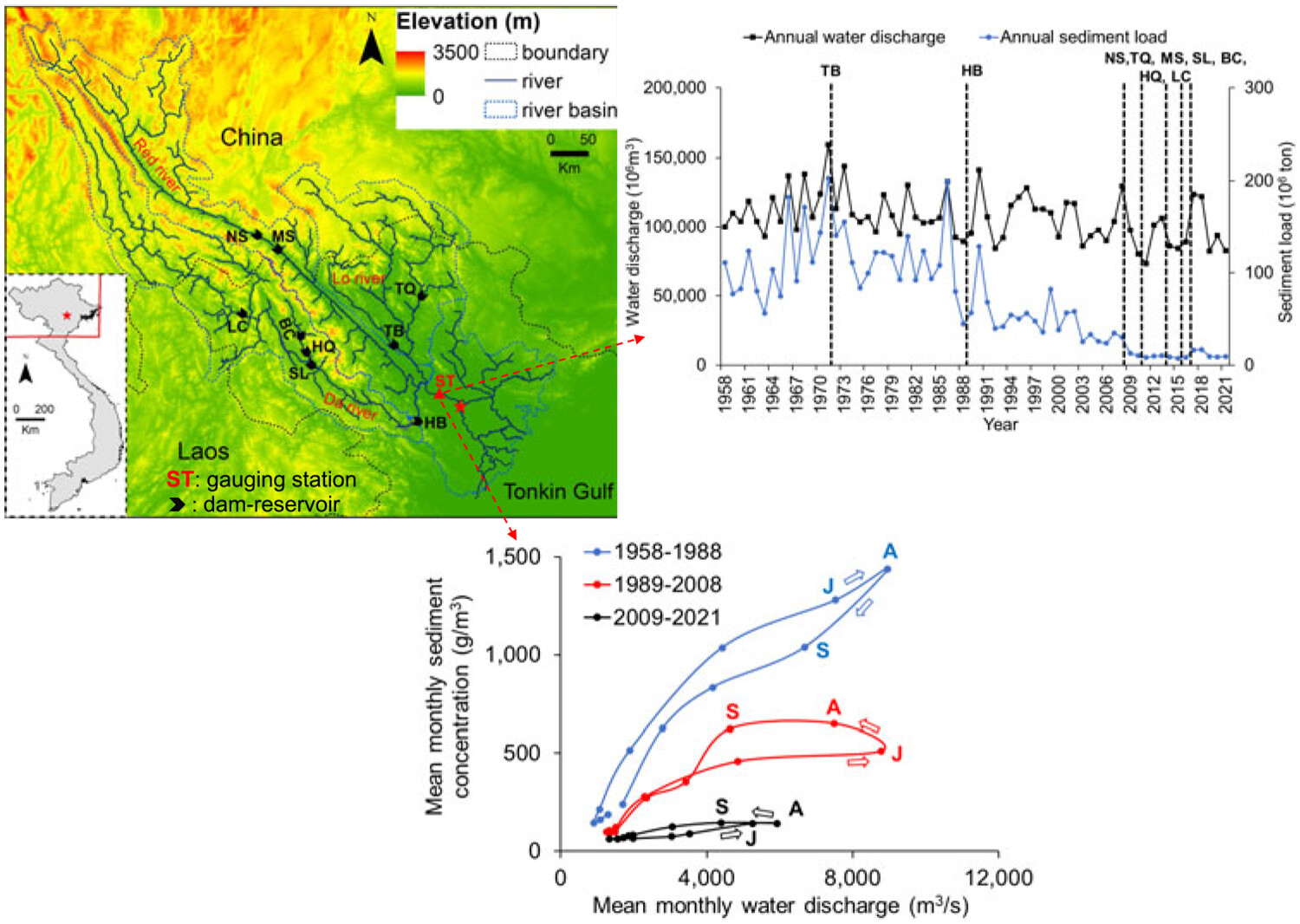
Since the early 1990s, sediment loads in the Red River system (Vietnam) have steadily reduced by approximately 91%. The Hoa Binh dam's impoundment in 1988 altered hydrological processes, changing their seasonality from clockwise to counterclockwise mode. This shift led to adjustments in rating curves. Notably, the dam effectively trapped 57.5% of sediments from 1989 to 2008 and 79% from 2009 to 2021, showcasing its success in sediment retention during these periods.
Remote detection of upland surface water storage capacity in deglaciated terrain
- Pages: 497-508
- First Published: 25 September 2023
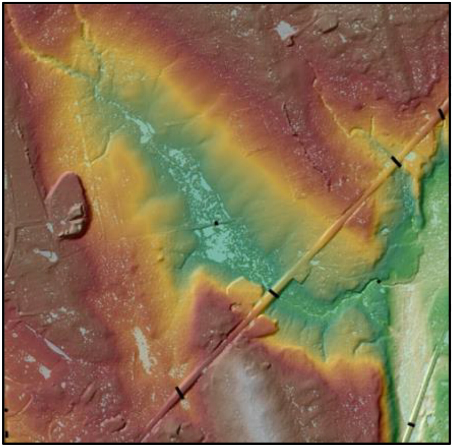
Remote detection of small-scale topographic variations (microtopography) in deglaciated landscapes using digital elevation models reveals patterns of surface water storage capacity that vary with slope and modern land cover.
Sign up for email alerts
Tools
More from this journal
- Award Winners
- Special Issues
- State of Science
- Call for Papers - Special Issue: The geomorphic signature of marine and continental Quaternary deposits
- Call for Papers - Special Issue: Earth surface processes and climate change at the Earth’s three poles
- Call for Papers - Special Issue: Novel approaches to quantify landscape changes (Cuchlaine King Symposium 2023)
- Call for Papers - Special Issue: Extreme Events in Geomorphology (Cuchlaine King Symposium 2024)
- Call for Papers - Special Issue: Applications of Artificial Intelligence in Geomorphology
- Call for Papers - Special Issue: Influence of tectonics and climate on landscape evolution: process and modelling
- Call for Papers - Special Issue: Fluvial processes and landforms in the Tibetan plateau in a period of rapid climate change
- Call for Papers - Special Issue: Wood in World Rivers 5
- Call for Papers - Spatial and temporal evolution of landslides induced by global climate change
- Call for Papers - Earth-Surface Processes in the Anthropocene: Human Impact, Climate Change, and Geomorphological Responses
- ESEX Commentaries
- BACKFILES An Online Archive from 1976 to 1995
- Other Resources
Latest Virtual Special Issues:
Is there a geomorphological case for the Anthropocene?
Chaired by Stephen Tooth, with panellists Professor Tony Brown, Simon Price and Professor Andreas Lang. Are we in the Anthropocene and no longer in the Holocene? Has human activity integrated and changed natural processes? Have we created our own geological time period?