

Journal list menu

 Issue
IssueEarth Surface Processes and Landforms: Volume 48, Issue 10
1907-2116August 2023
Export Citations
Download PDFs
ISSUE INFORMATION
RESEARCH ARTICLES
Investigation of buried karst sinkholes under a bog using ground penetrating radar (GPR) and electrical resistivity tomography (ERT)
- Pages: 1909-1925
- First Published: 04 April 2023
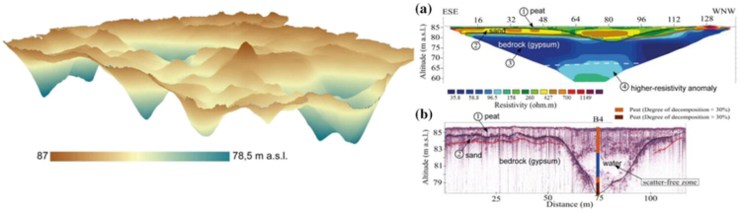
A geophysical study from a bog located over karst susceptible bedrock show karst activity, which has not been appropriately evaluated before. Both GPR and ERT results show water layers within peat-filled sinkholes.
Characterization of landslide displacements in an active fault zone in Northwest China
- Pages: 1926-1939
- First Published: 05 April 2023
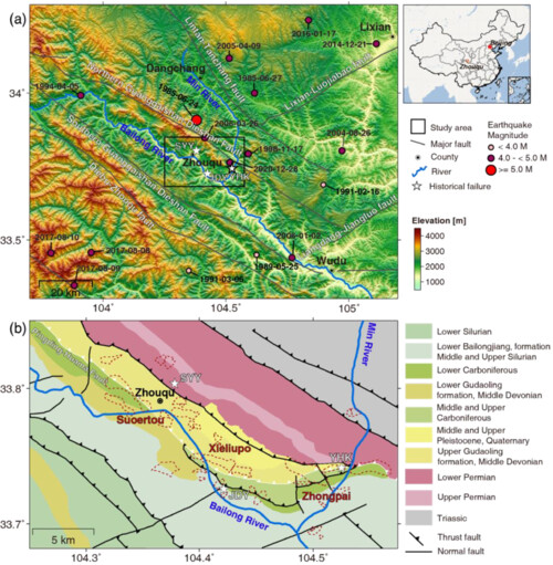
- Landslide kinematics in Pingding-Huama fault zone in China are resolved by Sentinel-1 satellite images during 2014–2020.
- The 2D displacement time series are constrained by the common-day ascending and descending InSAR measurements.
- Spatially, some landslides are overlapped with or bound the active faults; temporally, seasonal rainfall regulates the landslide speed.
Morphological change and its response to human activities in the estuary of Minjiang River, China, since last early century
- Pages: 1940-1955
- First Published: 09 April 2023
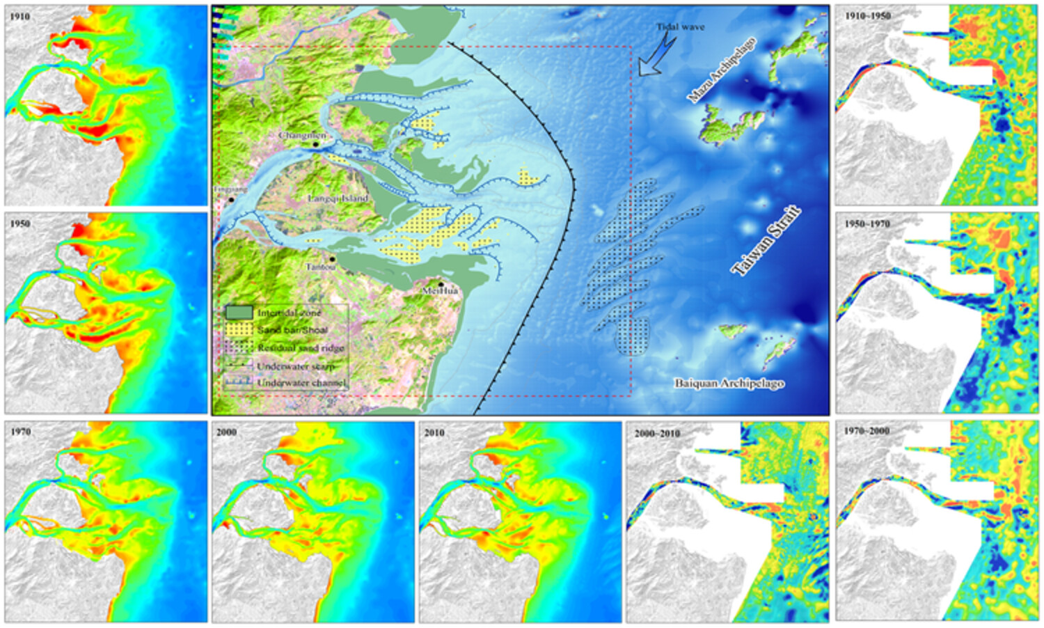
This paper presents an analysis of the Minjiang River as a small to medium-sized mountainous stream. By extracting and calculating bathymetric data from charts of the Minjiang estuary over the past century, we have determined that the response time of the Minjiang estuary subaqueous delta to significant human activities is less than 10 years. Furthermore, we have identified five distinct stages of MRD evolution that are influenced by varying intensities of human activities.
The interplay of bedrock fractures and glacial erosion in defining the present-day land surface topography in mesoscopically isotropic crystalline rocks
- Pages: 1956-1968
- First Published: 09 April 2023
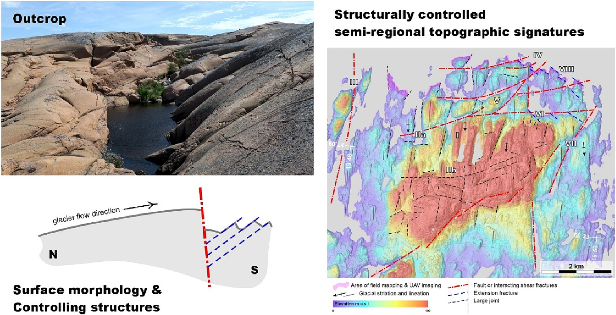
In this paper, we link natural fractures with outcrop morphologies and apply the findings in understanding the glacial erosion signatures in crystalline rocks.
Rock–water interaction, chemical weathering and solute transport of two rivers draining contrasting climate gradients in Western Ghats, India
- Pages: 1969-1989
- First Published: 09 April 2023
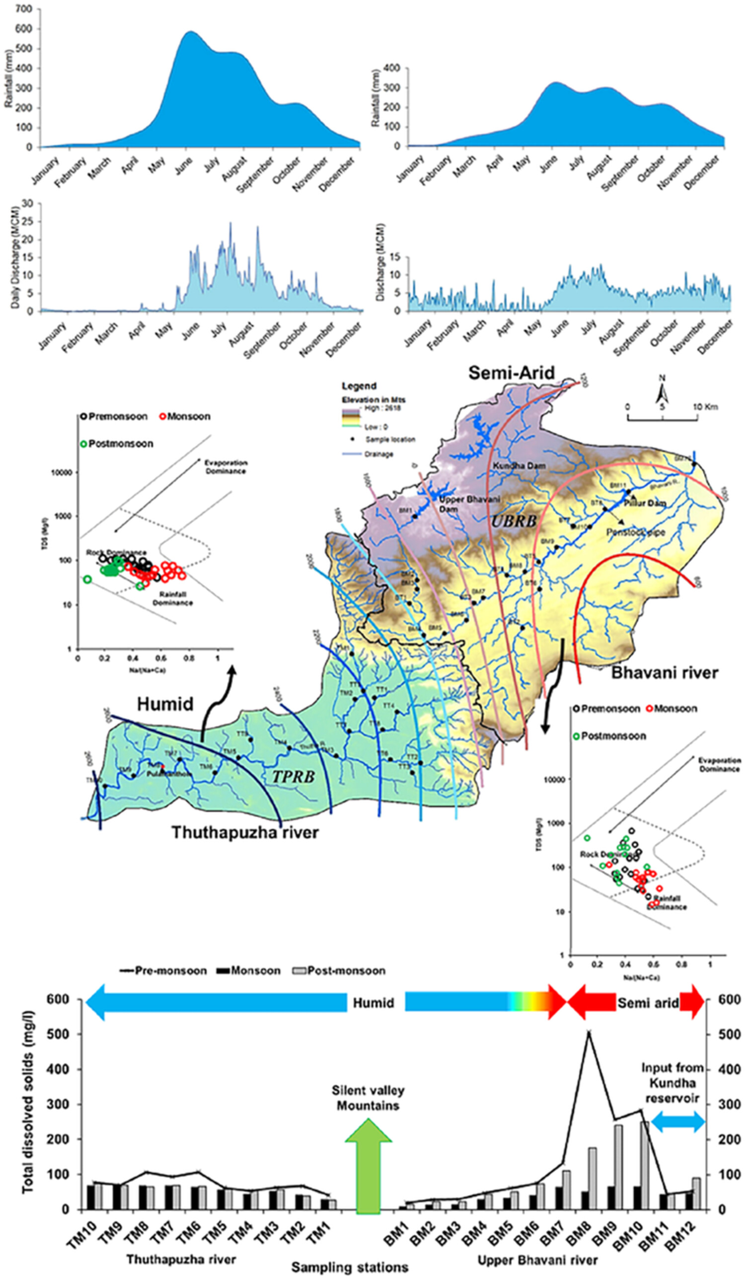
This paper deals with chemical weathering and its controlling factors that determine the quality and quantity of solutes in two mountainous, small catchment rivers draining contrasting climate gradients across the southern Western Ghats, India.
Controls of local grain size distribution, bed structure and flow conditions on sediment mobility
- Pages: 1990-2004
- First Published: 09 April 2023
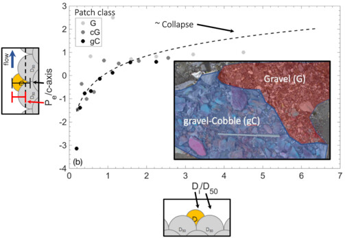
Our study has three major findings. First, protrusion generally increases with grain size, but for a given grain size, the protrusion decreases with patch coarseness. To measure protrusion, the immediate upstream elevation may be representative. Second, a single relation exists for all patch classes between relative grain size and dimensionless protrusion, indicating that relative grain size controls protrusion and hiding. Third, hiding functions for all tested patch classes were similar, suggesting that relative grain size controls critical Shields stresses.
Drainage development on the northern Tibetan Plateau controlled by the Altyn Tagh Fault: Insights from analogue modelling
- Pages: 2005-2022
- First Published: 12 April 2023
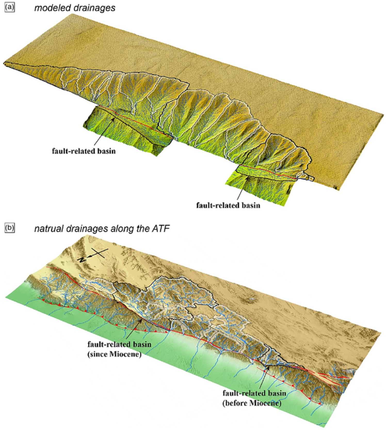
The drainage pattern on the northern Tibetan Plateau is characterized by the eastward deviation of the drainage area relative to the topographic window and two disproportional fault-related basins. Geomorphic sandbox modelling simulated the formation of the drainage pattern on the northern Tibetan Plateau and revealed that the large-scale horizontal slip of the Altyn Tagh Fault and the preexisting topographic window played dominant roles.
Riparian vegetation's effects on the evolution of an experimental meandering channel driven by an upper vortex flow
- Pages: 2023-2038
- First Published: 18 April 2023
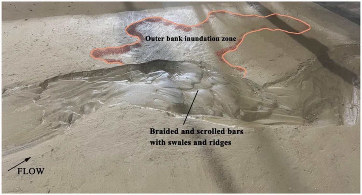
Downstream scroll bars replace transverse point bars in the meandering channel bed, unless there is a coupling of vegetation and flood. Vegetation helps to maintain the meandering channel pattern, but shallow-rooted plants are unable to withstand the inner-bank cutting effect of upper vortex flow. High-frequency topography along the thalweg is mainly distributed in the bare root disturbed region in the deep-rooted vegetation scenario.
Contribution of bedrock structures to the bedrock surface topography and groundwater flow systems within deep glaciofluvial aquifers in Kurikka, Western Finland
- Pages: 2039-2056
- First Published: 18 April 2023
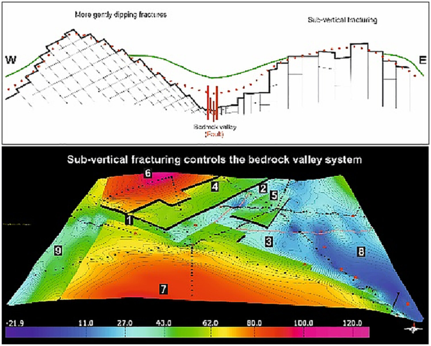
We address the relationship between the bedrock structure and bedrock surface topography through conducting structural analysis of the bedrock within the main recharge area of the Kurikka aquifer. Based on the presented results, it is evident that the initial bedrock-digital elevation model (DEM) with smooth elevation transitions from the elevated areas to the elongate depressions does not realistically represent the true fracture-controlled character of the bedrock surface topography.
A century of channel change caused by flow augmentation on Sixth Water Creek and Diamond Fork River, Utah, USA
- Pages: 2057-2078
- First Published: 19 April 2023
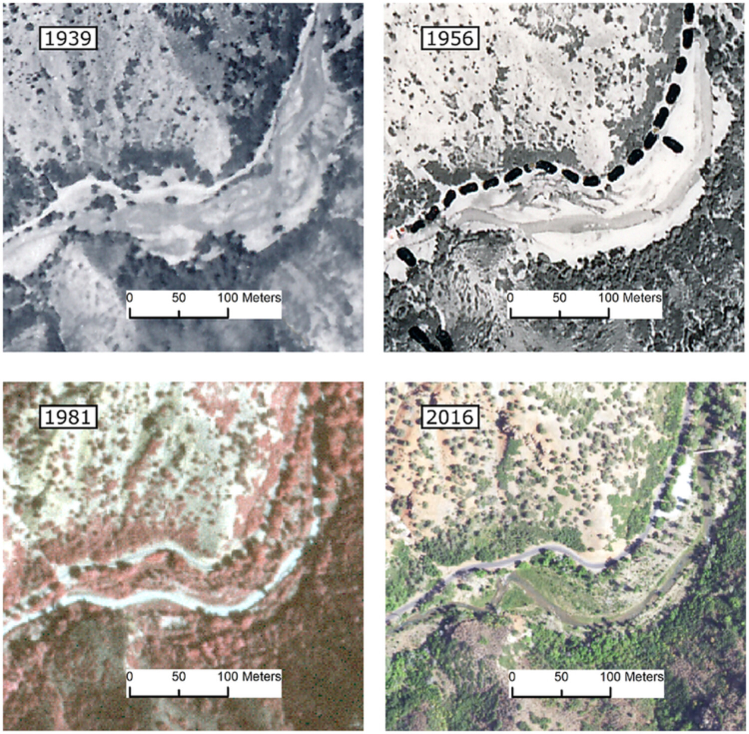
Persistent flow alteration because of transbasin diversion into a relatively small (400 km2) mountainous catchment created dramatic geomorphic change ranging from meters of incision to valley widening and braiding. Several factors determined how river reaches responded to flow alteration: the magnitude of augmentation relative to natural floods, channel confinement, timing of floods, transport capacity, and proximity to sediment sources. Elevated base flows because of management help to maintain an overwidened channel, which may be common in regulated rivers.
Dynamic and delayed channel geomorphic responses to changing hydrological processes following the Three Gorges Dam operation
- Pages: 2079-2099
- First Published: 18 April 2023
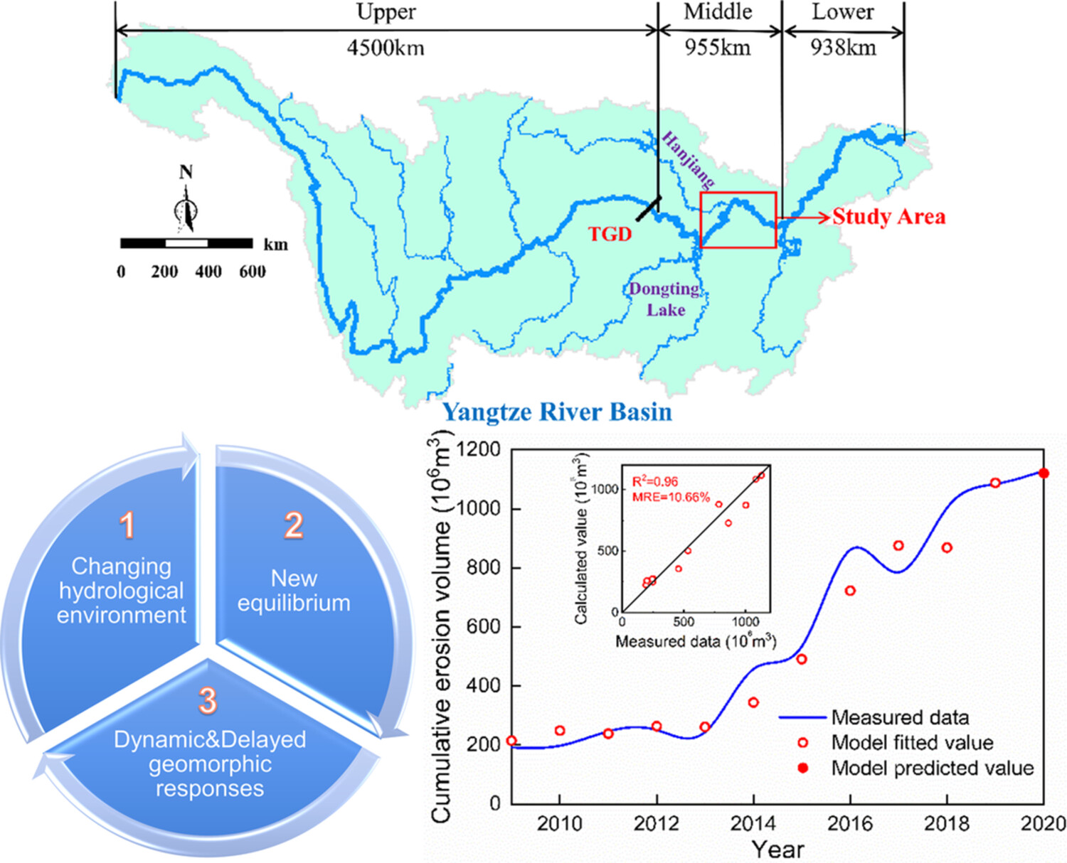
This river segment is relatively far (450 km) from the Three Gorges Dam and the post-dam evolutionary pattern developed from low-intensity alternating erosion/deposition to intense erosion, characterized by one-way incision and no evident channel narrowing/widening. This could be attributed to the greater sediment starvation, attenuated upstream sediment replenishment, adequate downstream sediment availability and increased geomorphic contribution of low-to-medium flows. This work provides valuable reference for determining channel morphogenetic hydrological processes and predicting channel self-adjustments towards equilibrium.
CASE STUDY
Coastal sedimentation and topographic changes in the Mataram Plain, Lombok (Indonesia) following the 1257 CE eruption of Samalas volcano
- Pages: 2100-2116
- First Published: 01 April 2023
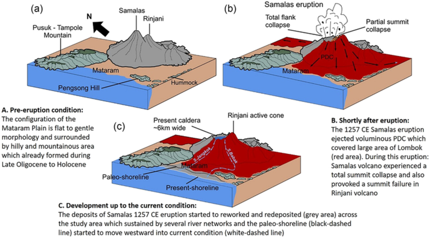
The sedimentation patterns in western Lombok following the 1257 CE Samalas eruption have been successfully reconstructed through paleo-topography and paleo-hydrography analysis, employing various stratigraphic data sources and geophysical measurements. Since the eruption of Samalas in 1257 CE, the study area has undergone abrupt and gradual changes. The abrupt changes caused by PDC deposition occurred in the upstream of study area, whereas the downstream area experienced gradual change by lahar and fluvial sedimentations. The landscape evolution in the study area has occurred in three stages. The first stage is the pre-eruption condition when the coastal area of Mataram Plain consisted of bays and headlands that were occupied by the coral reef environment in some parts. The second stage is the eruption stage when the PDC partially covered the study area with a total volume of 110 ± 3 × 10⁶ m3. In the last stage, there was progressive sedimentation by lahar and fluvial processes with a total preserved volume of 208 ± 3 × 10⁶ m3. As a result of this sedimentation, the shoreline has moved westward by an average of 1.6 km from its former position prior to the 1257 CE Samalas eruption.
Sign up for email alerts
Tools
More from this journal
- Award Winners
- Special Issues
- State of Science
- Call for Papers - Special Issue: The geomorphic signature of marine and continental Quaternary deposits
- Call for Papers - Special Issue: Earth surface processes and climate change at the Earth’s three poles
- Call for Papers - Special Issue: Novel approaches to quantify landscape changes (Cuchlaine King Symposium 2023)
- Call for Papers - Special Issue: Extreme Events in Geomorphology (Cuchlaine King Symposium 2024)
- Call for Papers - Special Issue: Applications of Artificial Intelligence in Geomorphology
- Call for Papers - Special Issue: Influence of tectonics and climate on landscape evolution: process and modelling
- Call for Papers - Special Issue: Fluvial processes and landforms in the Tibetan plateau in a period of rapid climate change
- Call for Papers - Special Issue: Wood in World Rivers 5
- Call for Papers - Spatial and temporal evolution of landslides induced by global climate change
- Call for Papers - Earth-Surface Processes in the Anthropocene: Human Impact, Climate Change, and Geomorphological Responses
- ESEX Commentaries
- BACKFILES An Online Archive from 1976 to 1995
- Other Resources
Latest Virtual Special Issues:
Is there a geomorphological case for the Anthropocene?
Chaired by Stephen Tooth, with panellists Professor Tony Brown, Simon Price and Professor Andreas Lang. Are we in the Anthropocene and no longer in the Holocene? Has human activity integrated and changed natural processes? Have we created our own geological time period?