A coordinated drainage and regulation model of urban water systems in China: A case study in Fuzhou city
Abstract
Extreme climate and urbanization lead to frequent urban floods, and urban water system dispatching is an important means of urban flood control. A coupled model is proposed to simulate urban floods in real-time and achieve comprehensive water system control for urban floods. First, the systematical description of coordinated drainage and regulation model of urban water systems in China is introduced, then the practice of Fuzhou city was taken as an example to introduce the prediction and forecast systems, as well as water system regulation for urban flood and waterlogging disaster in detail. Results show that the root-mean-square error of river flood prediction is less than 0.3 and that the calculation time of waterlogging simulation is less than 10 min; the optimization regulation reduces the peak river water level by 31 cm. This study will establish a novel urban water system management model to help urban managers better reduce the loss caused by urban floods.
1 INTRODUCTION
In the context of global climate change and urbanization, the frequency, scope, and intensity of extreme climate and hydrological events have increased, and a significant upward trend is revealed in the economic and property losses induced by flood and waterlogging disasters, which have become a major risk to the mid- and long-term development of China. The disasters caused by urban floods are characterized by great social impact, a high degree of concern, and wide coverage. In recent years, the increased frequency of weather-related extreme events, as well as urban rainstorms and waterlogging disasters, has aroused widespread public concern. Urbanized areas have faced intense pressure and serious challenges in the prevention and control of rainstorms, flood, and waterlogging disasters, especially those under rapid development. The phenomena of “cities in the sea” have been frequently observed in multiple cities in China, and the weakness and vulnerability of urban flood control have been exposed.
Severe rainstorms will cause traffic problems to varying degrees, which may subsequently cause heavy casualties and property losses if severe waterlogging disasters occur (Table 1). The major domestic and foreign urban flood disasters in the past 3 years are shown in Table 1. In addition, the two floods in February 2010 and June 2010 caused 41 and 26 deaths in France, respectively. Furthermore, floods threatened Bulgaria almost throughout 2014, causing massive property losses. Moreover, South Carolina was ravaged by a 1000-year flood in 2015, which killed at least 19 people and destroyed thousands of homes. In China, a rainstorm assaulted Beijing on July 21, 2012, making 63 of its main roads waterlogged, 30 of its roads with a waterlogged height of above 30 cm, 95 of its roads blocked due to a waterlogging condition, and several hundred cars severely damaged. The rainstorm covered an area of 16,000 km2, affecting an area of 14,000 km2 and a population of 1.9 million, and 79 people died due to the rainstorm. The disaster that has incurred the severest losses in recent years is the “July 20” rainstorm in Zhengzhou city. Its maximum daily rainfall reaches 624.1 mm, and its maximum hourly rainfall intensity reaches 201.9 mm, resulting in 380 deaths and a loss of RMB40.9 billion. In addition, the frequency of rainstorms and flood disasters in Shanghai, Guangzhou, Chongqing, and other major cities is extremely high, and some have even suffered from disasters in successive years. For example, besides the rainstorm on June 23, 2011, Beijing suffered severe waterlogging disasters on July 21, 2012, July 17, 2014, August 19, 2014, and July 19, 2016. In this context, the problem of “inevitable waterlogging disasters after rainstorms” in large cities has drawn considerable attention, and natural disasters such as waterlogging disasters in urban areas have sounded the alarm for the management of megacities.
| Event | Duration | Country/city | Losses |
|---|---|---|---|
| Flood in Bengal | July 2020–August 2020 | More than 1/3 of Bengal | More than 200 deaths |
| Flood in Western Europe | July 14, 2021–July 25, 2021 | Germany, Belgium, Netherlands | 205 deaths/US$43 billion |
| Flood in Indonesia | April 3, 2021–April 4, 2021 | Indonesia, Timor-Leste | 222 deaths |
| Flood in India | October 15, 2021 | India/Akande Nepal | 201 deaths |
| Flood in China | July 20, 2021 | China/Zhengzhou | 292 deaths/CNY53.2 billion |
| Flood in Pakistan | June 2022–September 2022 | Pakistan | 1559 deaths |
Urban flood prevention and control involves many departments. To better improve the urban flood prevention and control system, improve the ability and level of disaster prevention, reduction and relief, in addition to forecasting and early warning, scientific dispatching, and other aspects, it is also an important task to strengthen the construction of disaster prevention and control mechanism. Single reservoirs, sluices, or pumping stations can no longer effectively control flood risk. In contrast, the coordinated regulation of various types of water-related infrastructure with the function of water flow regulation has become a reliable option in the current phase (Fekete, 2019; Kataoka, 2011; Nakamura & Shimatani, 2021; Shao et al., 2018; D. Zhu, Mei, et al., 2021). However, it is well known that there are often multiple stakeholders in urban flood risk management. For example, in Singapore, the Building and Construction Authority has long been in charge of the protection of coastlines but is not responsible for the flood control of coastlines (Chan et al., 2018) In Europe, managers and spatial planners of water resources often adopt different governance models. Due to a series of problems, including the lack of support from local planning authorities, tensions between the central governments and the local governments, and the lack of coordination among stakeholders, as well as ambiguous risk assessments, there are always discrepancies between the management schedules and their implementation (Dieperink et al., 2016). In the Bay Area of San Francisco in the United States, although the federal government plays an important role in the management of large-scale floods, most of the legal powers and responsibilities for water resource management belong to authorities at the state and local levels. It is estimated that 100,000 local authorities and 300 state authorities are responsible for water-related issues in the United States, many of which have limited and sometimes conflicting mandates. Also, the regulation of water supply, water quality, and flood-related issues in the United States lacks coordination between policies and between a policy and its implementation. For example, in flood management, local land-use agencies have permitted residential developments within designated flood bypasses ((1) Governing for Integrated Water and Flood Risk Management: Comparing Top-Down and Bottom-Up Approaches in Spain and California). Multiple management authorities often face difficulties in producing consensus solutions to water-related incidents that are closely related and affect each other due to their different professional backgrounds, different perspectives, and conflicts of interests (Bosoni et al., 2020; Schramm & Schramm, 2018). As a consequence, even effective water management schedules are often insufficiently implemented or fail to deliver the expected performance timely. This is fatal for flood contingency management, which emphasizes the prime time for prevention and control (Judi et al., 2011; Q. Yang et al., 2020).
Taking the urban flood management in Fuzhou city (China) as an example, the Department of Water Affairs of the city is in charge of the city's flood control and related water conservancy facilities, while its Department of Urban Construction is in charge of the city's drainage and related drainage facilities. This pattern of decentralized management has long existed, which is clearly not an efficient management method, as the limited authority of water management is distributed to multiple departments (Cole et al., 2018; Loucks, 2007; Marlow et al., 2013). The highly decentralized coordination structure and weak reciprocal relationships between different organizations, as well as the lack of effective liaisons between organizations at each level, can seriously affect the efficiency of contingency response (Yeo & Comfort, 2017). In the face of the current situation in which hazardous events have become increasingly extreme, the lack of effective coordination and collaboration between multiple governmental departments can “forfeit the chance for combat” in case of material emergencies. Therefore, it is imperative for Fuzhou city to adjust the management system, eliminate the weak spots in the implementation of policies concerning urban flood control, and give full play to the benefits of the limited water-related facilities of the city, so as to cope with the increasingly severe situation concerning the occurrence of disasters.
Overall, the main shortcomings of nonengineering measures for urban flood control in China include the following aspects. First, the organizational structure is unsatisfactory. Currently, water system management in most areas is not unified, involving multiple departmental authorities in charge of water conservancy, water affairs, municipal engineering, contingency management, and other affairs. This pattern of water management by multiple authorities makes it difficult to maintain consistency between policies and their implementation, resulting in the slow coordinated management of urban water systems, slow regulation, and the response thereof. Second, the prediction and forecast system is unsatisfactory, and the prediction of reservoir inflow, water levels of rivers and lakes, and urban waterlogging depths is insufficient. Although many cities are gradually promoting the research and construction of real-time urban flood and waterlogging forecasting and have yielded desired results, complicated and fluctuating environments, as well as technical constraints, still limit the promotion and application of urban flood and waterlogging forecasting. Third, the integrity and consistency of engineering regulation of urban water systems are insufficient, and the regulation schedules are unsatisfactory. Therefore, it is particularly important to be able to quickly and comprehensively predict the urban flood risk and put forward a model for rapid regulation based on the optimization algorithm.
To comprehensively predict the urban flood with a provide scheduling suggestions rapidly, in this context, a coordinated drainage and regulation model for the prevention and control of urban flood and waterlogging disasters is proposed in this study, which aims to provide new insight into the management and construction of urban water systems. Moreover, the main content of this mode will be introduced in Section 2, and a case study of its application in Fuzhou city will be introduced in Section 3. Section 4 presents a summary.
2 A COORDINATED DRAINAGE AND REGULATION MODEL
2.1 The coordinated drainage and regulation model proposed in this study
To improve the applicability of urban flood simulation in urban water system dispatching, a coordinated drainage and regulation model is proposed, and the workflow is shown in Figure 1.

The coordinated drainage and regulation model combines hydrological and hydrodynamic models. For urban drainage basins, runoff is calculated based on a hydrological model. For channel, a one-dimensional (1D) channel river model under rainfall scenarios is built with river sections, pumps, reserves, and the regulations and drainage pipes, and the calculated river water level is set as the downstream boundary for 1D–2D (two-dimensional) coupling urban drainage pipe network and surface flood prediction model. Real-time operation decision is provided based on the predictive control model.
 ()
() ()
() is the distance,
  is the time,
  is the volumetric flow rate,
  is the flow area,
  is the hydraulic head of water in the conduit,
  is the friction slope, and
  is the acceleration of gravity.
 ()
() denotes the change in cell water depth,
  denotes the change in cell volume,
  denotes the time interval, and
  and
and  denote the orthogonal directions. The flow of two adjacent cells is calculated using the Saint-Venant inertial equation:
 ()
() is the flow rate on the boundary of adjacent cells,
  is the gravity acceleration,
  is the roughness,
  is the water level gradient of the adjacent units, and
  is the water flow depth at the interface of the adjacent cells, which is defined as follows:
 ()
() and
and  and
and  and
and  denote the water depth and ground elevation of the two adjacent cells, respectively.
2.2 Prediction and forecast systems for urban flood and waterlogging disasters
From the perspective of application scenarios (Qi et al., 2021), the prediction and forecast systems for urban flood and waterlogging disasters include presimulated forecasting systems and real-time forecasting systems (Davis et al., 2022; Wang et al., 2022). Prediction and forecast systems are often used in the planning of urban flood control. With the development of cities and the improvement of monitoring capabilities, the application of real-time forecasting systems has gradually become popularized.
From the perspective of system principles, these models are mainly mechanism-based or data-driven. Mechanism-based systems simulate the physical rules and characteristics that processes such as rainfall, runoff generation, and concentration, as well as underground and surface water flows, obey, which mainly adopt the integrated hydrological hydrodynamic models. Hydrological modeling is used to simulate the physical processes of runoff generation and concentration in urban catchment areas under different rainfall conditions. 1D hydrodynamic modeling is often used to simulate the dynamic process of drainage in areas with fixed flow directions, such as drainage networks and river channels, in terms of hydrological elements including water levels and flow. 2D hydrodynamic modeling is often used to simulate the evolution of the vertical and horizontal flow velocity distribution in areas such as urban surfaces, rivers, and lakes. Mainstream simulation software for urban flood and waterlogging disasters includes SWMM (Koc et al., 2021; Paule-Mercado et al., 2017; Rai et al., 2018; Sun et al., 2022; Y. Yang et al., 2021; Zeng et al., 2021), HEC-RAS (Bush et al., 2022; Shustikova et al., 2019; Tamiru & Wagari, 2022; Vozinaki et al., 2017), LISFLOOD-FP (Z. Liu & Merwade, 2018; Wilson et al., 2007; X. Wu, Wang, et al., 2018), InfoWorks ICM (Chen et al., 2022; Hosseinzadehtalaei et al., 2021; Peng et al., 2016; Z. Zhu et al., 2016), MIKE (Bisht et al., 2016; C. Q. Li & Wang, 2012; H. L. Liu et al., 2007; M. M. Rahman et al., 2011), and FLO-2D (Erena et al., 2018; Hsu et al., 2010; M. H. Li et al., 2011). In addition, variations in the flow fields of some key areas, including estuaries, coasts, water pumps, and sluices, are also simulated with 3D hydrodynamic modeling, while the anisotropy of fluids is fully considered. The 3D modeling software includes but is not limited to Delft3D (Dissanayake & Brown, 2022; Mendes et al., 2021; A. Rahman & Venugopal, 2017), FLOW-3D (Erduran et al., 2012; Lee & Lee, 2021; Taha et al., 2020), and OpenFOAM (Duguay et al., 2017). In China, plenty of individually developed models have also been gradually improved and applied, including Hydro-Info (Yu et al., 2022) and IFMS Urban (X. T. Li et al., 2022; J. Wu, Yang, et al., 2018). All the above-mentioned mechanism-based models are listed in Table 2.
| Model | Features | Major simulated processes | Developer |
|---|---|---|---|
| SWMM | With distributed hydrological modules and one-dimensional hydrodynamic modules | Urban runoff generation and concentration, drainage network hydrodynamics, river channel hydrodynamics | EPA (US Environmental Protection Agency) |
| HEC-RAS | With one- and two-dimensional hydrodynamic modules | Drainage network hydrodynamics, river channel hydrodynamics, surface hydrodynamics | HEC (US Army Engineer Hydrologic Engineering Center) |
| PCSWMM | Based on SWMM; with pre-and posttreatment modules; supporting the simplified calculation of surface two-dimensional parameters | Urban runoff generation and concentration, drainage network hydrodynamics, river channel hydrodynamics, simplified surface waterlogged process | CHI (Computational Hydraulics International, Canada) |
| LISFLOOD-FP | With two-dimensional hydrodynamic modules | Two-dimensional urban surface hydrodynamics | University of Bristol, UK |
| InfoWorks ICM | Highly integrated; fully featured; supporting integrated hydrological and hydrodynamic water quality simulation; with powerful pre- and posttreatment functions | Surface runoff generation and concentration, one-dimensional river channel hydrodynamics, one-dimensional drainage network hydrodynamics, two-dimensional surface waterlogged contamination spread | HR Wallingford, UK |
| MIKE | With modules including MIKEURBAN, MIKEFLOOD, and MKIE21 | Surface runoff generation and concentration, one-dimensional river channel hydrodynamics, one-dimensional drainage network hydrodynamics, two-dimensional surface waterlogged process | DHI (Danish Hydraulic Institute) |
| Delft3D | Suitable for three-dimensional hydrodynamic water quality simulation; supporting hydrodynamic simulation for estuaries and ports | Three-dimensional hydrodynamics | Department of Hydraulic Engineering of Delft University of Technology, the Netherlands |
| FLO-2D | With two-dimensional hydrodynamic modules, and embedded SWMM modules for one-dimensional calculation | Two-dimensional hydrodynamics | FLO-2D Software, Inc., US |
| FLOW-3D | CFD software; with three-dimensional hydrodynamic modules; suitable for the analysis of three-dimensional flow fields | Mechanical processes of fluids, three-dimensional river channel hydrodynamics | Flow Science, Inc., USA |
| HydroInfo | Supporting numerical simulations for complex flow and transport processes | One-dimensional river channel and drainage network processes, two-dimensional water flow, sediment, and wave processes, 3D free surface flow model | Dalian University of Technology |
| HydroMPM | Supporting numerical simulations for water flow, water quality, sediments, and other dynamic processes, as well as their associated processes | One-dimensional river channel process, two-dimensional surface hydrodynamics | Pearl River Water Resources Research Institute |
| GAST | Supporting solving the two-dimensional Saint-Venant equation sets using a Godunov-type scheme; supporting accelerated computation using GPU(Graphic Processing Unit) parallel computing | Watershed runoff generation and concentration, two-dimensional surface hydrodynamics | Xi'an University of Technology |
| IFMS/Urban | Based on the individually developed GIS(Geographic Information System) platform; supporting integrated one-dimensional and two-dimensional computation | One-dimensional drainage network hydrodynamics, two-dimensional surface hydrodynamics | China Institute of Water Resources and Hydropower Research |
| ITF-Flood | An integrated Web system platform; supporting online real-time computation, presentation, and integrated forecasting of waterlogging disasters at the urban level | One-dimensional drainage network hydrodynamics, two-dimensional surface hydrodynamics | China Institute of Water Resources and Hydropower Research |
Data-driven systems adopt machine learning models, which can be used to simulate urban flooding processes, including urban flood lvel (Jiang et al., 2022; M. M. Rahman et al., 2011; Zahura et al., 2020), water levels of reservoirs, lakes and drainage networks, surface waterlogged depth, and water flow (Bermúdez et al., 2019), as well as to conduct sensitivity analysis and risk assessment of urban flood and waterlogging disasters (Janizadeh et al., 2019; Saravanan & Abijith, 2022; Youssef et al., 2022; Zhao et al., 2020). The machine learning-based waterlogging simulation establishes a model through data analysis and maps the correlations and variation patterns between time-series data to make timely and accurate prejudgments on the variation tendency of time series in future research. The volume and accuracy of data are the foundation of the construction of machine learning models and the key to the generalization ability of the models. According to different sources of data, machine learning-based waterlogging forecasting models can be divided into simulation-based computational models (Z. Guo, Moosavi, et al., 2022; Y. Guo, Quan, et al., 2022; Hou et al., 2021; Löwe et al., 2021; T. Yang et al., 2019), and models based on enormous monitoring data. The former is often used to offset shortcomings, including insufficient coverage of monitoring and scenarios, while the application of the latter has gradually become available as the monitoring systems of urban water-related facilities improve.
Overall, mechanism-based models utilize knowledge of the mechanisms of water circulation and waterlogging processes in urban watersheds, and their computational efficiency is low. Data-driven models probe into the intrinsic patterns of the sample data and have the advantages of high prediction efficiency and easy modeling. However, the interpretability of their simulated results is relatively poor. Therefore, the integration of the two kinds of models, or the exploration of the patterns of the sample data based on knowledge of natural mechanisms, will be the major direction of future research on urban waterlogging forecasting.
2.3 Water system regulation for urban flood and waterlogging disasters
2.3.1 River channel regulation
The extreme water scarcity in nonflood seasons and the frequent occurrence of floods in urban inland rivers are caused by the uneven distribution of water resources in time and space. So, it is imperative to figure out how to make full use of rainwater, flood, and tidal resources to improve the water environment in urban construction. Sluice and pump station regulation is an important process of dealing with the uneven distribution of water resources in time and space, which plays a positive guiding role in urban river ecology, waterlogging management, and relevant decision-making (Bai et al., 2020). Early sluice and pump station regulation mainly adopts predetermined regulation schedules based on empirical judgments, such as reservoir antiflood capacity maps and flood prevention regulation maps, to facilitate decision-making. With the development of hydrological and hydrodynamic simulation technologies, as well as mathematical and computational algorithms, scholars have already started to study the distribution and allocation of water resources by integrating hydrological models, hydrodynamic models, and mathematical optimization algorithms. J. Zhu, Zhang, et al. (2021) integrated a 1D hydrodynamic model and a genetic algorithm to optimize the control process of the sluice pump station project of the Shijiazhuang–Beijing section of the Central Line Project of the South-to-North Water Diversion. This study achieved good results, which showed that the optimized model demonstrated a better control effect than the conventional control approach, as the number of sluice operations was reduced by 23.38%. Ashofteh et al. (2015) used a genetic algorithm to optimize the flow distribution schemes of the Aidoghmoush Reservoir and its downstream irrigation network in East Azerbaijan (Iran) in the current condition and in scenarios with climate changes, obtained the optimal process of water supply, and achieved the optimal decision-making for water distribution. Shen et al. (2022) adopted an improved PID (Proportional-Integral-Derivative) algorithm to study the Central Line Project of South-to-North Water Diversion and the drainage tank of the No. 4 sluice in the Grand Canal. This control algorithm for water storage compensation can suppress water level fluctuations to a certain extent, and its control meets the constraint conditions. In general, the methods of studies on flow regulation and water resource distribution have gradually transformed from scenario simulation based on single hydrological, hydrodynamic, or optimized models to the integration of optimized models with hydrological and hydrodynamic models. In contrast to the relatively mature research on reservoir regulation at the scale of watersheds, the current research on the optimized regulation of the urban river, and drainage networks in terms of ecology and flood control is relatively scarce.
2.3.2 Drainage control and regulation
The real-time control (RTC) of a drainage system refers to the online real-time monitoring of the data of the system and the subsequent implementation of a series of rule-based control measures for the adjustment of the operating status of water conservancy facilities of the system, including sluices and water pumps, so as to give full play to the regulation and storage facilities of the system, and eventually achieve the objective of flood control and disaster reduction. The methods of RTC have been applied in urban drainage systems since the 1980s, as the first RCT software program for drainage systems was put into use in 1983. In the 21st century, with the development of computational technology and automation devices, RTC technology has become an advanced and mature technology with broad applications.
As a technology for urban drainage systems, RTC can achieve control objectives, including improving the operation of urban sewage systems, reducing overflow in drainage systems, and appropriately utilizing urban water regulation and storage facilities. Moreover, in comparison with conventional measures such as increasing water regulation and storage facilities and expanding drainage pipes and channels, RCT has a lower cost. Taking the Wastewater Treatment Plant of Vienna as an example, a new regulation and storage tank with a volume of 25.5 × 10⁴ costs €100 million, while a scheme using RTC to utilize the original volume with the same effect appropriately costs only 23% of building a new tank (Fuchs & Beeneken, 2005). In short, the application of RTC can improve the operating status of urban drainage systems and help the systems to continue to adapt to the changing external conditions (Beeneken et al., 2013; Fradet et al., 2011; García et al., 2015; Seggelke et al., 2013; van Daal et al., 2017).
The core of RTC for drainage systems is the establishment of a valid control rule. The means to establish such a rule include trial methods and mathematical optimization methods. Trial methods solve problems mainly based on operators’ experience in regulation, while mathematical optimization methods seek the optimal regulation rule through the optimization algorithms and establish the corresponding simulation model to conduct predictions of the future state of a system, as well as validate the effect of the established regulation rule (Jafari et al., 2018). In 2004, Schütze et al. described the results of the application of RTC in urban drainage at that time and speculated that the direction of future development of RTC was to realize RTC of drainage systems through the establishment of surrogate models, that is, model predictive control (MPC), so as to achieve more accurate predictive control (Schütze et al., 2004). However, the computational efficiency of the predictive model (a hydrodynamic model) in MPC has severely impeded the application of MPC in drainage. Scholars then used alternative methods, including Gaussian process emulators (Mahmoodian et al., 2018; Owen & Liuzzo, 2019) and artificial neural networks (Kim et al., 2019; Latifi et al., 2019; Sayers et al. 2014, 2019; Seyedashraf et al., 2018; Yazdi & Neyshabouri, 2014) to establish the surrogate models, so as to reduce computational cost. For example, Omid Seyedashraf used multilayer perceptron and generalized regression neural networks to simulate the outflow process of complex drainage networks.
3 CASE STUDY
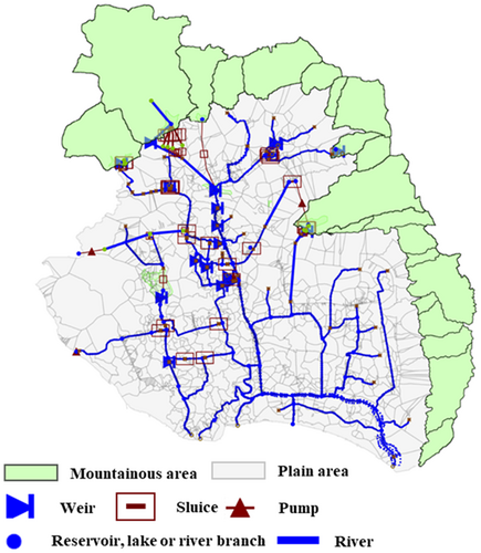
This paper takes Fuzhou city as the research area, which is a city in Fujian Province, China, located in the core area of the “21st Century Maritime Silk Road,” and has been listed as a strategic fulcrum city for coastal economic development. Due to its superior geographical location, the development of urban economy has higher requirements for the defense ability of flood disasters. The Jiangbei (north of the Fujian's Min River) Area of Fuzhou city covers an area of 109 km2. It is located on the west bank of the Taiwan Strait, facing the sea and backed by the Wuyi Mountains. Its southeast direction has a high water vapor transport flux, while the mountainous terrain of the Wuyi Mountains in the northwest results in the frequent occurrence of typhoons and local short-duration heavy precipitation in this area. The area is located in a low-lying area prone to waterlogging, surrounded by mountains in three directions and facing the sea in one direction. The area is also densely covered by rivers, as there are 64 inland rivers in the area, with a total length of 138.6 km and an average water network density of over 3 km/km2. The intersected inland rivers have formed five major water systems: the western water system, dominated by the Baima River, along with 12 other inland rivers, with a total length of about 21 km; the central water system, dominated by the Jin'an River, along with other 14 inland rivers, with a total length of about 25.3 km; the eastern water system, dominated by the Moyang River, along with other six inland rivers, with a total length of about 19 km; the estuary water system, dominated by Guangming Port, along with 20 inland rivers, with a total length of about 46 km; the Xindian water system, with nine inland rivers and a total length of about 27.3 km. The construction standards for the water systems are capable of withstanding a 5-year flood. Moreover, the area has 1366 km of rainwater drainage pipes and channels, with an average coverage density of 13.1 km/km2 and a design standard capable of withstanding a 1-year flood. The inland rivers of Fuzhou city are connected to the tidal channels in the lower reaches of Fujian's Min River. Affected by the tide, the inland rivers also ebb and flow. In addition, Fujian's Min River (Fuzhou section) is the main river channel for the shipping and drainage of Fuzhou. The water systems of Fuzhou's inland rivers and the distribution of the relevant facilities are shown in Figure 2.
3.1 Real-time urban flood prediction and forecast system of Fuzhou city
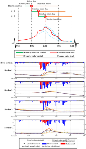
As for the flood prediction of urban river channels, an SWMM model was adopted to simulate the river channels of Fuzhou city and conduct rolling forecasting through precipitation extrapolation from radar echoes. The Saint-Venant equation sets were adopted as the governing equations describing the transient flow. After the formulation of the model, the boundary conditions for the upstream, the downstream, and the two sides were set. The upstream boundary conditions mainly refer to the hydrographic conditions of inflow from the mountainous areas. The downstream boundary conditions refer to the water level conditions at the downstream outflow areas determined by the machine learning-based prediction of tide-level hydrographs. In contrast, the boundary conditions for the two sides refer to the truncated rivers during the demarcation of watersheds determined by the hydrographic data of flow in mountainous areas. Meanwhile, a set of control rules for sluices and pump stations was formulated to predict variations in the water levels of the river channels with different methods of regulation. Each simulation adopted the latest measured precipitation as the precipitation of the retrospective stage and the real-time forecast precipitation based on historical radar data as the precipitation of the predictive stage.
Taking the precipitation data from 12:00 on May 16, 2020 to 03:00 on May 17, 2020, as a case, the total precipitation in the areas where the four river sections are located is 69.32, 65.74, 38.75, and 52.17 mm, respectively. The rainfall event is a short-term heavy rainfall event. The four corresponding cross-sectional root-mean-square error values of the radar precipitation forecasting-based simulation are 0.1872, 0.0782, 0.2723, and 0.1006, respectively (Figure 3).
As for urban waterlogging prediction, a multilevel and multiscale waterlogging prediction and forecast model was formulated against multiple application scenarios. On the scale of the whole city, a large-scale waterlogging tendency prediction model was formulated, while factors including terrain, types of underlying surfaces, and drainage capacity were mainly considered. On the scale of local areas, detailed model-based grid waterlogging predictions were conducted, while hydrodynamic processes including water level variations of river channels and drainage networks were rigorously taken into account.
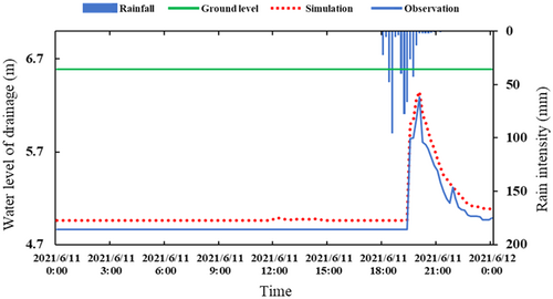
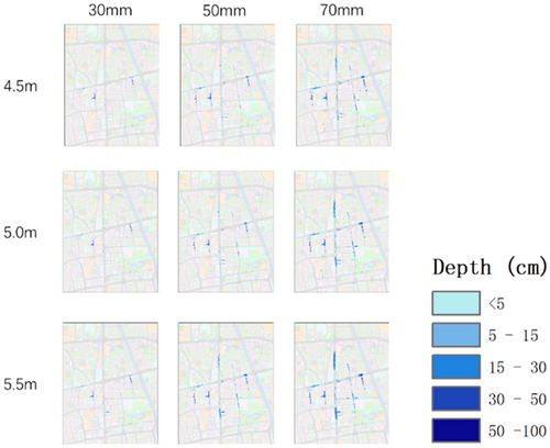
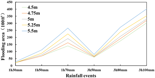
On the scale of the whole city, the ITF-Flood model was used to form grid cells with a resolution of 5 m. Urban infiltration was then calculated by land type, and drainage networks were generalized into infiltration capacity based on their construction standards, so that the urban surface runoff was derived. The city-scale model is mainly used to simulate the impact on the degree of urban waterlogging of long-term rainstorms that are heavier than 10-year rainstorms. As the model adopts the GPU parallel computing technology, its computational time on RTX 3090 (graphic card) for the simulation of precipitation during the next 24 h is less than 25 min. On the scale of local areas, drainage sections were divided in accordance with the distribution of drainage networks and river channels, and 1D drainage network models were formulated based on integrated ITF-SWMM models, in which the hydrographic data of confluence areas were calculated through the model for surface runoff generation and concentration and the jacking effect of high water levels of river channels was taken into account. A 1D drainage network model and the corresponding 2D surface model based on Digital Elevation Model (DEM) (with a resolution of 2 m) were integrated to conduct the 2D evolutionary computation of the surface overflow of urban drainage networks, so as to complete the formulation of the urban waterlogging prediction and forecast models. The computational time for a single simulation of 24-h precipitation is less than 10 min. The models are suitable for the simulation of waterlogged processes under the impact of multiple factors, including river channels, precipitation, and surface runoff. The calibration and results are shown in Figures 4, 5 and 6.
3.2 Water system regulation for urban flood control in Fuzhou city
The flood control idea of the current flood control operation system in Fuzhou city is to promptly study the possible future flood control risk level and activate the corresponding level of operation plan based on weather forecasts, the operation of the city's gate and pump constructions, and the water monitoring values at critical points. The operation rules for different levels of operation schemes for operation elements such as gates and pumps are established as per the topography, climate, hydrogeology, engineering operation objects, historical operation schemes, and the operation experience of frontline personnel in Fuzhou. After years of operation practice, the current flood control operation rules effectively resist the risk of flooding caused by short-duration heavy rainfall and typhoon rainfall. However, there is still room for further optimization. To address the existing operation problems of Fuzhou's urban water system, this paper established a real-time urban river flood operation model based on a predictive control model in Fuzhou. Based on the rainfall-runoff forecasting results, the operation model can generate a real-time operation scheme that satisfies the engineering operation strategy according to the optimization conditions and then carry out rolling optimization and error correction according to the operation results to obtain a new real-time operation scheme.
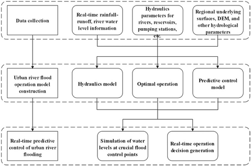
The constituent elements of the real-time urban river flood operation model mainly include hydraulic structures such as river channels and gates and pumps. The hydraulics model is constructed by collating basic information such as the corresponding channel cross-section parameters, regional underlying surfaces and DEM, and generalizing complex internal structures such as water gates, pumping stations, and rubber dams. The simulation is carried out by calling the model to obtain the temporal and spatial variation of water level and flow at each river section and each control section. The MPC control algorithm is then used to implement the generation of real-time operation decision plans for urban river flooding. The technical route of the model is shown in Figure 7.
- (a)
Lowest water level
 ()
() - (b)
Maximizing impoundment
 ()
() is the maximum value of the water level at the observation point m of the reservoir lake or river at the tth optimization period, m.
  is the minimum value of the water level at the observation point m of the reservoir lake or river at the tth optimization period, m.
  is the upper limit of the water level at the observation point m of the reservoir lake or river level, m.
  is the lower limit of the water level at the observation point m of the reservoir lake or river level, m. T is the rainfall forecast period, min.
The constraints of the model include water level constraints, flow constraints, water balance constraints, and flow balance constraints:
 ()
() ()
() ()
() ()
() is the value of the downstream flow rate of reservoir lake m at the tth optimization period, m3/s.
  is the upper water level of the reservoir lake m.
  is the lower water level of the reservoir lake m, m3/s.
  is the volume of reservoir lake m at the tth optimization period, m3.
  is the inflow to reservoir lake m at the tth optimization period, m3/s.
  is the outflow to reservoir lake m at the tth optimization period, m3/s.
  is the side inflow at the reservoir lake or river level observation point m at the tth optimization period, m3/s.
Taking the Jiangbei Area as an example, this paper constructed a real-time urban river flood operation model and selected the designed rainfall for operation simulation analysis to obtain the optimal operation decision plan and the water level change process of the corresponding flood control point under this scenario. The area includes the Bayi Reservoir, Jingdian Lake, Qinting Lake, and Guangming Port for flood control operations. Among them, the Bayi Reservoir and Jingdian Lake are important reservoirs and lakes of the upper reaches of Qinting Lake, respectively. In addition to ensuring their own flood control requirements, they can be combined with Qinting Lake for staggered flood operation to reduce the flood control pressure on Qinting Lake. Qinting Lake is one of the most important lakes in the Jiangbei Area and is prominent in flood control operations. Guangming Port is a vital river channel in the lower reaches of Qinting Lake. The flood water discharged from Qinting Lake flows through the Jinan River into Guangming Port and is discharged out to the Minjiang River through three pumping stations along the river gates.
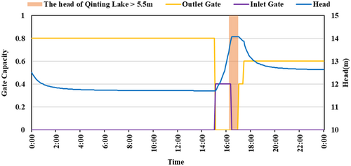
The operation results obtained from the optimization of this paper for Bayi Reservoir and Jingdian Lake are shown in Figures 2 and 3. When the water level of Qinting Lake is higher than 5.5 m during the forecast period, Bayi Reservoir and Jingdian Lake start to store flood water to reduce the pressure of flood control in Qinting Lake. When the water level of Qinting Lake drops below 5.5 m, the flood water from Bayi Reservoir and Jingdian Lake is staggered to release.
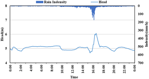
The results of the operation optimization of Qinting Lake are shown in Figures 8 and 9, with its maximum water level within an acceptable range. Qinting Lake will be predischarged when there is a danger of the water level exceeding the warning level during the forecast period. When Qinting Lake continues to impound floodwater, and the water level exceeds 5.5 m, the upstream flood control facilities go into joint operation mode. When the water level in Guangming Port falls back, the flood water from Qinting Lake is staggered to release.
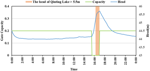
The regular operation refers (Figures 10 and 11) to the operation of the appropriate level of plan in accordance with the weather forecast and the experience of the frontline operators. Optimal operation refers to operation by invoking the operation decisions calculated by the real-time urban river flood operation model. This paper compared and analyzed the operation results of the Jiangbei Area under two operation decision scenarios. The results showed that the optimal operation method improved the efficiency of emergency treatment of urban drainage and flood control in Fuzhou, reduced the risk of flood prevention and discharge, reduced the peak water level at crucial control points by more than 7%, delayed the peak water level by more than 40 min, and increased the regulation and storage capacity of reservoirs, lakes, and rivers by more than 11%.
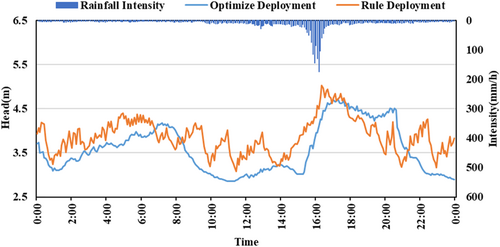
A comparison of the results of the Guangming Port operation is shown in Figure 5. Under both operation scenarios, the water level in Guangming Port is within the range of not exceeding the warning level. The maximum flood level at Guangming Port under “optimal operation” is 4.71 m, which is lower than the result of 5.02 m under regular operation. The maximum flood level at Guangming Port was at 17:20 under optimal operation, which was 55 min later than at 16:25 under regular operation. The water level fluctuation under optimal operation is minor, which is more secure and reliable. Based on the above analysis, the operation results obtained by “optimal operation” is better.
4 CONCLUSION
Cities are complex giant systems. Under extreme rainstorm conditions, urban flood has evolved from a single disaster to a disaster chain. In particular, the failure of key infrastructure such as water, electricity, gas, road, and network may cause a series of chain reactions, thus amplifying the impact and loss of disasters. Therefore, it is necessary to build a large emergency frame for systematic response. It is necessary to treat the relationship between urban “external flood and internal waterlogging” from the perspective of the river basin, establish an emergency framework for the coordination between the river basin and the city, realize the joint prevention and control of urban “external flood and internal waterlogging”, and improve the systematicness and coordination of urban flood control.
The coordinated drainage and regulation model presents a systematical management for the urban flood. Fuzhou city has successfully passed multiple severe tests of the flood seasons since 2018, including Typhoon Maria (196 mm/24 h) in 2018, short-term heavy rainfall on September 17, 2018 (106.7 mm/h), and continuous heavy rainfall from May 15 to 19, 2019 (87.7 mm/h). A large portion of contributions is attributed to the effective management by the Coordinated Drainage and Regulation Center of Fuzhou city. However, there were also obstacles, which mainly included the insufficient professional competence and regulation experience of the management personnel. Most of the personnels of the newly established centers are personnels transferred from the old institutions, who lack relevant professional knowledge and adequate experience, so the center still greatly relies on externally employed experts. The improvement of such a situation should be achieved, on the one hand, by conducting continued education on relevant majors for existing personnel and employing more professional technical personnel. On the other hand, as for the accumulation of regulation experience, measures for intelligent management should be taken. The processes and results of the regulation for each risk event should be meticulously recorded and reviewed, the characteristics and information of each event should be fully explored, and the experience and lessons from each event should be timely summarized and utilized in the regulation for the next risk event, so as to continue to promote scientific and efficient management decision making. In the construction of flood infrastructure in coastal cities, the types of urban drainage should be updated, the design standards of drainage facilities and the storage capacity of urban water system should be increased, and an engineering system of urban drainage flood prevention including source emission reduction, process control, and terminal treatment should be formed. The artificial intelligence technology with ChatGPT as the milestone can integrate knowledge extraction, semantic representation, knowledge fusion and deep learning to build the knowledge map of water conservancy filed. Therefore, with the development of the AI technology, urban water system regulation will usher in innovation. However, the research result has not been fully applied widely, so how to use ChatGPT to serve urban flood control and disaster reduction will be an important task in the future.
ETHICS STATEMENT
None declared.
Open Research
DATA AVAILABILITY STATEMENT
The data that support the findings of this study are available from the corresponding author upon reasonable request.


