Effect of water depth and waterway obstructions on the divergence and confluence areas of Dongting Lake and the Yangtze River after the operation of the Three Gorges Project
Abstract
Climate change and human activities have profoundly changed the evolutionary processes and developmental trends of the hydrology and geomorphology of rivers and lakes. Such changes have affected the evolution of bars and channels at the intersections of rivers and lakes and the utilization of water depth resources in waterways, which, in turn, have affected the sustainable development of waterways, such as the “Golden Waterway” of the Yangtze River. Considering the confluence of Dongting Lake and the Yangtze River as the present study area, we analyzed the effect of the hydrology of Dongting Lake and the evolution of bars and channels in the Jingjiang reach of the Yangtze River on the depth of the waterways. Our results indicated that from before the operation of the Three Gorges Project (1960–2002) to after its operation (2003–2021), the flow and sediment volume of the three inlets of Dongting Lake demonstrated a continuous decreasing trend. Furthermore, the relative increase in the runoff of the Jingjiang reach increased channel erosion. Channel erosion at the river–lake confluence from 2003 to 2021 created favorable conditions for increasing the dimensions of the waterways. The total length of the river–lake confluence that did not meet the requirements for safe navigation [4.5 × 200 m (water depth × width)] was 12.6 km, accounting for 68.35% of the total length of the Jingjiang reach with obstructed navigation. We observed that a decrease in the low-water level and “steep slope and rapid flow” were the major factors hindering the navigation of the reach (from Zhicheng to Dabujie) affected by the Songzikou diversion of Dongting Lake. This was mostly reflected by the width of the 4.5 m waterway being less than 200 m. A declining water level, shrinking sandbanks and tidal flats, and alternating branches that destabilize the low-water route were the major factors hindering navigation in the reach (from Taipingkou) affected by the Taipingkou diversion of Dongting Lake. Consequently, alternative waterways were implemented during low-water periods with the water depth decreasing below 4.5 m. The obvious collapse of sandbanks and tidal flats and their erosion and migration were the major factors hindering navigation of the Ouchikou diversion of Dongting Lake. In addition, the scattered submerged shoals in the navigation channel restricted the width of the 4.5 m channel to less than 200 m. The reach affected by the Dongting Lake confluence (from Xiongjiazhou–Chenglingji reach) was subject to the erosion and silting of bends and the jacking effect of lake outflow, causing shoals with a water depth of less than 4.5 m in the channel. However, the jacking effect slowed the current, thereby assisting in improving channel conditions.
1 INTRODUCTION
Amid intense human activities and global climate change, the hydrology (Y. Wang et al., 2022; Yin et al., 2022), sediment, and geomorphological processes of most of the world's lakes have changed profoundly (Grant et al., 2021; Mammides, 2020; Y. Yu et al., 2018). Dongting Lake, the second largest freshwater lake in China, is an important waterbody in the middle reaches of the Yangtze River. Water from the upper reaches of the Yangtze River enters Dongting Lake through three distributaries that feed the lake, namely Songzikou, Taipingkou, and Ouchikou. The lake is fed by four other major rivers, namely, the Xiangjiang, Zishui, Yuanjiang, and Lishui rivers. Dongting Lake flows back into the Yangtze River at Chenglingji, forming a complex river–lake relationship (Huang et al., 2012). Owing to climate change and human activities, the relationship between Dongting Lake and the Yangtze River has undergone several changes since the beginning of the 20th century (Q. Han et al., 2016; S. Zheng, 2016). The start of the Three Gorges Project (TGP) in 2003 led to a period of new adjustments in the river–lake relationship (Lai et al., 2014; Y. T. Li et al., 2009; Xiao et al., 2021), which have, inevitably, affected the depth of the waterways. Shipping on the Yangtze River supports local economic and social development, with waterway transportation on this river reaching 3.26 billion tons by 2021, accounting for 77.8% of the inland waterway transportation in China. Accordingly, further research should be conducted on the TGP and its features along with the influencing mechanisms of obstructions to navigation in the divergence and confluence areas of Dongting Lake and the Yangtze River. Such research should support the sustainable development of the “Golden Waterway” and the utilization of waterway depth resources.
Over the past 20 years, research on the changing river–lake relationship in response to the TGP has focused on the temporal and spatial evolution of water and sediment in the Dongting Lake area (C. Zhang et al., 2016), water exchange capacity of the Yangtze River and Dongting Lake (Lai & Wang, 2017; Mao et al., 2017; Zhu et al., 2016), floods (Geng et al., 2021; Lai & Wang, 2017; Y. Wu et al., 2019), and river and lake volumes (Liao et al., 2018; Lu et al., 2018), along with the ecological and environmental factors (Lu et al., 2018; C. Zhang et al., 2016, 2020). The TGP has affected the mainstream flow of the Yangtze River by drying up Dongting Lake and reducing the volume of water entering the lake (J. Wang, Sheng, et al., 2017). From 2003 to 2008, natural inflow, reservoir regulation, and riverbed erosion contributed 76.19%, 10.32%, and 13.49%, respectively, toward the reduction in the flow through the three distributaries that feed Dongting Lake. From 2009 to 2015, the respective figures were 66.05%, 19.75%, and 14.20% (Chen et al., 2018). The postflood impoundment period of the TGP further reduced the water level of Dongting Lake, and the cascade reservoirs in the upper reaches have increased the effect on the lake (C. M. Fang et al., 2014). From 1971 to 2002, the TGP was the major cause of the decreased volume of sediment transported from Dongting Lake after the Jingjiang reach Cut-off Project, as the siltation of the lake area changed to erosion (Lu et al., 2018; Zhu et al., 2016) along with shrinkage of the sandbanks and tidal flats (S. C. Yu et al., 2019). A mathematical model has predicted that the decrease in the middle- and high-water levels of the Jingjiang reach would be limited to 20 years after the TGP (Y. T. Li et al., 2009); however, the riverbed elevation of the flood channels at the three distributaries would decrease significantly, although the diversion ratio of the three distributaries would not decrease, and the ratio of the current distribution of the three distributaries would not be reduced. The prediction was quite similar to what has ensued (Y. P. Yang, Liu, et al., 2022; Y. P. Yang, Zheng, Zhang, et al., 2022). Under a scenario of the lake volume remaining constant, the reduced outflow from Dongting Lake would be approximately 23% of the water storage capacity of the Three Gorges Reservoir (TGR) (D. D. Zhang et al., 2019). Under a scenario of different water flow levels, the mutual jacking intensity of the river and lake would be weakened (Duan et al., 2019). The outflow of Dongting Lake during the dry season was slower in the period 2003–2012 than in the period 1981–2002. The decreased speed could be ascribed to the rising water level of the Yangtze River at the Chenglingji outlet, which has a jacking effect on Dongting Lake (H. Zheng et al., 2015). Under a scenario with the same flow rate at Zhicheng hydrological station on the Yangtze River, the outflow from the Jianli station would be weakened by the jacking intensity of the outflow from Dongting Lake. In addition, the outflow from this lake would be weakened by the jacking intensity of the discharge from the Jingjiang reach (D. D. Yu et al., 2017). Following the construction of the TGR, the erosion of Dongting Lake led to an increase in the low-water level and the depth of the waterway (M. Zhang et al., 2015). Subsequently, after the operation of the TGP, the volume of sediment entering the middle reaches of the Yangtze River has significantly reduced (Y. P. Yang, Zheng, Zhu, et al., 2022), causing strong erosion in the Jingjiang reach (Y. P. Yang et al., Zhou, et al., 2022). The first phase of the waterway improvement project in the Jingjiang reach increased the depth of the waterway from 2.9 m in 2002 to 3.5–3.8 m in 2018 (Yan et al., 2019; Y. Yang et al., 2019). Considering the terrain in February 2014 as the basis for the verification of waterway conditions, the depth of the waterways from Yichang to Wuhan and Wuhan to Anqing reaches increased from 3.5 and 4.5 m to 4.5 and 6.0 m, respectively (Y. Yang et al., 2019). Moreover, the water depth of the estuary of the Yangtze River reached 12.5 m (Dai & Liu, 2013; Dai et al., 2018) and gradually extended to the Nanjing reach (Y. P. Yang, Zheng, Zhang, Zhu, Chai, et al., 2021). The complex relationship between changes in the hydrodynamics, sediment transport, and sandbank and tidal flats in the river–lake confluence area is significant, as it is a key river section for waterway management, dredging, and maintenance (Dong et al., 2020). Research has been conducted on erosion and silting (Xia et al., 2017; Y. P. Yang, Zhang, Zhu, et al., 2018), changes in sandbanks and tidal flats (Yang, Zheng, Zhang, Zhu, Zhu, et al., 2021; Zhao et al., 2020), distributary relationships (Hu et al., 2020; L. S. Liu, Li, et al., 2017; H. H. Liu, Yang, et al., 2017; Y. P. Yang, Zheng, Zhang, Zhu, Zhu, et al., 2021), and obstructions to navigation (M. Li, Hu, et al., 2021; Y. Yang et al., 2019) in the confluence area of Dongting Lake and the Yangtze River after the construction of the TGR. The focus has primarily been on water–sediment flux in confluence areas, changing relationships between the river and lake, and utilization of water resources.
The Jingjiang reach, which is affected by the confluence of the Yangtze River and Dongting Lake, is the region of interest in this study. We used water and sediment data from 1960 to 2021 and topographic data from 2002 to 2021 to analyze the hydrological effects of Dongting Lake. In addition, we studied the effect of changes in bars and channels located in the Jingjiang reach on the waterway conditions and navigation obstructions in the river–lake confluence area. The research aimed to support the sustainable development of deep-water resources in the Yangtze River. The study can promote the sustainable development of deep-water resources in the Yangtze River.
2 STUDY AREA, DATA, AND MODEL
2.1 Study area
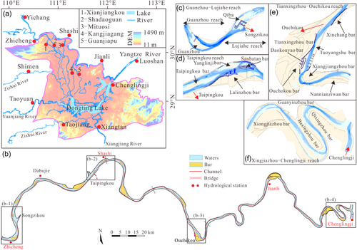
Dongting Lake is located on the southern side of the Yangtze River. The Songzikou, Taipingkou, and Ouchikou streams flow into the lake, and the lake further merges with the Yangtze River at the river port of Chenglingji (Figure 1a). The river reaches affected by the divergence areas of the three streams are the Guanzhou–Lujiahe, Taipingkou, and Ouchikou reaches. The Xiongjiazhou–Chenglingji reach is affected by the confluence area (Figure 1b). The hydrological stations along the Jingjiang reach are Zhicheng, Shashi, Jianli, and Luoshan. The Xinjiangkou and Shadaoguan station and the Mituosi station are located along the Songzikou and the Taipingkou inflow, respectively. The Tangjiagang and Guanjiapu stations are located along the Ouchikou inflow. Whereas the Chenglingji station is located at the confluence with the Yangtze River (Figure 1b). Songzikou is the first diversion area from the Yangtze River to Dongting Lake, covering the reach from Zhicheng to Changmenxi, with the mid-channel bars being Guanzhou and Lujiahe reach (Figure 1c). A waterway improvement project was implemented in the Zhicheng–Changmenxi reach between 2014 and 2016 to stabilize the diversion and reshape the bars and channels to create a waterway that stabilized the flat positions of Guanzhou and Qiba mid-channel bars which inhibited the rapid development of branches. By 2022, the channel reached water depth, width, and bend radium of 3.5 × 150 × 1050 m, respectively. Taipingkou is the second diversion area from the Yangtze River to Dongting Lake (Figure 1d), covering the Taipingkou reach. The mid-channel bars are Taipingkou and Sanbatan, and the point bars are Lalinzhou and Yanglinji. Two phases of a waterway improvement project were implemented at Sanbatan from 2005 to 2012, mostly to stabilize the bars. From 2010 to 2017, two phases of a preservation project were implemented at Lalinzhou to stabilize the waterway boundary. By 2022, the water depth, width, and bend radius reached 3.5 × 150 × 1050 m, respectively. Ouchikou is the third diversion area from the Yangtze River to Dongting Lake (Figure 1e), covering the Tianxingzhou–Ouchikou reach. The diversion includes the Xinchang point bar, Tianxingzhou and Tuoyangshu point bar, Ouchikou mid-channel bar, Doukouyao mid-channel bar, and Xiangjiazhou point bar. The Tianxingzhou and Tuoyangshu point bars are mostly affected directly by the Ouchikou diversion area. From 2010 to 2013, projects were implemented to preserve the high bar on the left edge of Tianxingzhou and the lower section, as well as a bank protection project at the Tuoyangshu point bar. A project was implemented to protect the Daokouyao mid-channel bar and Tuoyangshu and Xinchang point bar from 2014 to 2016. After the implementation of the waterway project in the Ouchikou reach, by 2022, the water depth, width, and bend radius of the channel reached 3.5 × 150 × 1050 m, respectively. No waterway improvement projects have been conducted in the Xiongjiazhou–Chenglingji reach. However, the water resources department has conducted river control and shoreline regulation projects (Figure 1f), such that the channel dimensions of water depth and width were 3.5 × 150 m, respectively, but the bending radius remained 1050 m.
2.2 Research data
Water level, flow, and sediment discharge data from the Zhicheng, Shashi, Jianli, and Luoshan hydrological stations were obtained for the period 1960–2021 to analyze changes in water and sediment conditions in the Jingjiang reach. Water and sediment volume data from the hydrological stations along the Songzikou (Xinjiangkou and Shadaoguan), Taipingkou (Mituosi), and Ouchikou (Guanjiapu and Tangjiagang) inflows, as well as the Chenglingji hydrological station, were obtained for the period 1960–2021 to analyze water and sediment conditions in the Dongting Lake area. Riverbed topographical data for the Jingjiang reach were obtained for the period 2002–2021 to analyze the waterway conditions, changing sandbanks and tidal flats, and cross-section changes in the Dongting Lake–Jingjiang reach confluence area (Table 1). The above data were obtained from organizations or institutions, including the Changjiang Waterway Administration, Water Resources Department of the Changjiang Water Resources Commission, Yangtze River Waterway Planning and Design Institute, Changjiang Waterway Survey Center, and Changjiang Sediment Bulletin.
| No. | Hydrological station | Location | Data type | Time |
|---|---|---|---|---|
| 1 | Zhicheng | Mainstream | Water level, flow, and sediment | 1960–2021 |
| 2 | Shashi | Mainstream | ||
| 3 | Jianli | Mainstream | ||
| 4 | Luoshan | Mainstream | ||
| 5 | Xinjiangkou | Songzikou of Dongting Lake | ||
| 6 | Shadaoguan | |||
| 7 | Mituosi | Taipingkou of Dongting Lake | ||
| 8 | Guanjiapu | Ouchikou of Dongting Lake | ||
| 9 | Tangjiagang | |||
| 10 | Chenglingji | Dongting Lake into the Yangtze River control station |
2.3 Model approach
 ()
()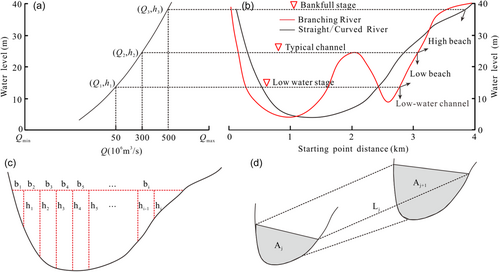
 ()
() ()
() ()
()3 RESEARCH RESULTS
3.1 Changing runoff and sediment of the Yangtze River
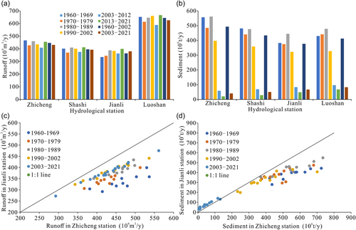
The runoff of the Jingjiang reach of the Yangtze River fluctuated during the period 1960–2021. From 1960 to 2002, the runoff figures at the Zhicheng, Shashi, Jianli, and Luoshan stations were 446.6 × 10⁹, 396.1 × 10⁹, 364.4 × 10⁹, and 644.2 × 10⁹ m3/year, respectively. From 2003 to 2021, the figures were 431.1 × 10⁹, 393.1 × 10⁹, 380.3 × 10⁹, and 625.5 × 10⁹ m3/year, respectively. The changes amounted to −3.47%, −0.76%, +4.38%, and −2.89%, respectively (Figure 3a). From 1960 to 2021, the sediment volume in the Jingjiang reach decreased gradually and has been decreasing continuously since 1990 (Figure 3b). From 1960 to 2021, the sediment at the Zhicheng, Shashi, Jianli, and Luoshan stations demonstrated a decreasing trend, with figures of 493 × 106, 434 × 106, 377 × 106, and 415 × 106 t/year, respectively, from 1960 to 2022. The figures for the period 2003–2021 were 41 × 106, 50 × 106, 67 × 106, and 83 × 106 t/year, respectively, with the changes amounting to −91.75%, −88.39%, −82.23%, and −79.88%, respectively (Figure 3b). Owing to the effect of the three diversion areas, the runoff of Jianli station was lower than that of the Zhicheng station during 1960–2021, and significantly lower during 2003–2021 compared with that during 1960–2002 (Figure 3c). The sediment volume of the Jianli station was consistently lower than that of the Zhicheng station from 1960 to 2002. However, the sediment volume of the Jianli station was higher than that of the Zhicheng station from 2003 to 2021. Further, although a sedimentation effect was observed from the three distributaries, the riverbed between Zhicheng and Jianli stations was being eroded (Figure 3d).
3.2 Changing runoff and sediment of Dongting Lake
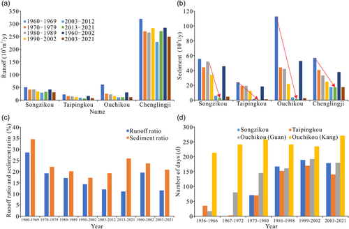
From 1960 to 2021, the runoff and sediment volume of the three inlets to Dongting Lake decreased (Figure 4a,b). The decrease in the ratio of sediment distribution was greater than that in the ratio of current distribution (Figure 4c). Moreover, under the same flow at Zhicheng, the ratio of the current distribution of all the three inlets decreased (Figure 4d). From 1970 to 2021, the runoff data pertaining to Chenglingji station displayed waveform changes. No significant trend was observed, but the runoff was lower than that observed during the period 1960–1969. The runoff figures for the three inlets to Dongting Lake, namely Songzikou, Taipingkou, and Ouchikou, were 41.4 × 10⁹, 15.9 × 10⁹, and 30.1 × 10⁹ m3/year, respectively, from 1960 to 2002. Similarly, it amounted to 30.8 × 10⁹, 8.0 × 10⁹, and 11.1 × 10⁹ m3/year, respectively, from 2003 to 2021. Runoff decreased by 25.64%, 50.09%, and 62.95%, respectively (Figure 4a), and the total decrease in runoff for the three inlets was 42.93% (Figure 4c). The sediment discharge figures for the three inlets to Dongting Lake are 45.66 × 10⁶, 18.39 × 10⁶, and 52.88 × 10⁶ t/year, respectively, from 1960 to 2002. Similarly, it amounted to 4.66 × 10⁶, 1.11 × 10⁶, and 2.73 × 10⁶ t/year, respectively, from 2003 to 2021. Sediment decreased by 89.80%, 93.95%, and 94.84%, respectively (Figure 4b), and the total decrease in the sediment of the three inlets was 92.73%. The periods 2003–2021 and 1960–2002 demonstrated decreases in runoff and sediment at Chenglingji station by 12.50% and 54.08%, respectively (Figure 4b). From 1960 to 2002, the ratio of sediment distribution of the three inlets to Dongting Lake was higher than the ratio of current distribution, implying a decrease in the sediment content of the Jingjiang reach owing to the diversion effect of the three inlets. From 2003 to 2021, the ratio of sediment distribution was 9.3% higher than the ratio of current distribution, which exceeded the 4.1% difference for the period 1960–2002 (Figure 3c). During the period 1956–2021, the siltation and shrinkage of the three inlets of Dongting Lake and the entrance of the lake caused the water level of the three inlets to increase. Owing to the increase in the water level and the influence of upstream flow processes, the Songzikou, Taipingkou, and Ouchikou stations did not experience flow for many years, and the annual number of days without flow increased (Figure 3d). During the period 1956–2002, Songzikou, Taipingkou, Ouchikou (Guan), and Ouchikou (Kang) were cut off for 81, 83, 95, and 198 days, respectively, whereas during the period 2003–2021, this number increased to 178, 140, 180, and 271 days, respectively, an increase of 97, 57, 85, and 73 days, respectively. After the operation of the TGP, the Jingjiang reach in the middle reaches of the Yangtze River was eroded by the river channel (Yang, Zheng, et al., 2022b; Y. P. Yang, Zhou, et al., 2022), and the flow and low-water level showed a downward trend (Chai et al., 2020; Y. Yang et al., 2017; Y. P. Yang, Zhang, Sun, Han, et al., 2018). Simultaneously, small-scale erosion occurred predominantly at the three inlets and flood channels (Wei et al., 2022); however, offsetting the impact of the water level decline of the mainstream was difficult. Consequently, the diversion at the three inlets of Dongting Lake will be reduced or maintained at the current low water level.
3.3 Sediment erosion and deposition
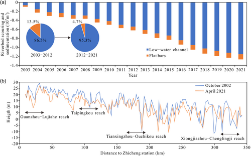
From 2003 to 2021, long-distance cumulative erosion occurred in the Jingjiang reach, with an erosion of 1.152 × 10⁹ and 1.266 × 10⁹ m3 at the low-water and flat bars, respectively, with the proportion of low-water channel erosion being 91.0%. The proportions for the periods 2003–2012 and 2012–2021 were 86.5% and 95.3% (Figure 5a). From 2002 to 2021, the thalweg of the Jingjiang reach was undercut. The Guanzhou–Lujiahe reach thalweg in the Dongting Lake distributary area was eroded and undercut in one direction. In addition, the thalwegs of the Taipingkou, Tianxingzhou–Ouchikou, and Xiongjiazhou–Chenglingji reaches were eroded (Figure 5b).
3.4 Verification of waterway conditions
The National Plan for Development of a Modern Comprehensive Transportation System for the 14th Five-Year Plan (January 19, 2022) and the National Plan for Water Transport Development for the 14th Five-Year Plan Period (February 9, 2022) stated, “The upper reaches of the main stream of the Yangtze River will actively promote improvements to navigation obstructions in key waterways of the Yibin–Chongqing reach and construction of a 4.5-m deep waterway in the Chongqing–Yichang reach. In the middle reaches, waterway improvements from Yichang to Wuhan reach will be promoted in an orderly manner. In the lower reaches, the improvement in the key waterway from Anqing to Nanjing reach will be implemented steadily, and the 12.5-m deep-water channel in the Yangtze River from Nanjing to the estuary will be further improved.” According to the Feasibility Study Report on the Second Phase of the Waterway Improvement Project in the Jingjiang reach in the Middle Reaches of the Yangtze River approved by the Ministry of Transport, the size of the waterway in the Jingjiang reach will be improved to 4.5 × 200 × 1050 m. According to the maintenance water depth of the main channel of the Yangtze River in 2022 announced by the Changjiang Waterway Bureau, the minimum water depth of the Songzikou, Taipingkou, Ouchikou, and Xiongjiazhou–Chenglingji reaches were 3.5, 3.5, 3.5, and 3.8 m (http://www.cjhdj.com.cn/), thereby achieving the goal of efficient waterway governance. Based on the measured water depth and topography of the river channel in March 2021, with the required channel dimensions being 4.5 × 200 m, 16 waterways of 18.4 km in total length were observed to be below the required dimensions, thereby obstructing navigation of 5.3% of the total length of the Jingjiang reach (Table 2). The length of the obstructed waterways was affected by Songzikou, Taipingkou, and Ouchikou. In addition, the confluence of Dongting Lake was 12.6 km, accounting for 68.35% of the total length of obstructed waterways.
| No. | Waterway name | Waterway mileage (km) | Minimum depth (m) | Minimum width (m) | Length of water depth less than 4.5 m and width less than 200 m (km) |
|---|---|---|---|---|---|
| 1 | Zhicheng | 6 | 5.5 | 150 | 0 |
| 2 | Guanzhou | 10.9 | 3.9 | 150 | 0.4 |
| 3 | Lujiahe | 11.1 | 2.5 | 65 | 1.8 |
| 4 | Zhijiang | 10 | 3.3 | 50 | 2.0 |
| 5 | Liuxiang | 5.6 | 4.6 | 300 | 0 |
| 6 | Jiangkou | 7.5 | 3.9 | 50 | 0.8 |
| 7 | Dabujie | 11.3 | 4.3 | 120 | 0.5 |
| 8 | Yuanshi | 17.1 | 4.3 | 180 | 0.3 |
| 9 | Taipingkou | 17.5 | 4.1 | 100 | 1.5 |
| 10 | Wakouzi | 9.1 | 2.7 | 130 | 1.8 |
| 11 | Majiazui | 12.5 | 6.1 | 330 | 0 |
| 12 | Douhudi | 9.9 | 6.3 | 400 | 0 |
| 13 | Majiazhai | 9.8 | 5.5 | 345 | 0 |
| 14 | Haoxue | 6.7 | 4.5 | 200 | 0 |
| 15 | Zhougongdi | 10.1 | 4.2 | 0 | 2.7 |
| 16 | Tianxingzhou | 16.9 | 7.6 | 410 | 0 |
| 17 | Ouchikou | 7 | 5.5 | 310 | 1.1 |
| 18 | Shishou | 10 | 6.5 | 300 | 0 |
| 19 | Nianziwan | 17 | 6.2 | 250 | 0 |
| 20 | Hekou | 5 | 8.5 | 335 | 0 |
| 21 | Tiaoguan | 16 | 5.5 | 260 | 0 |
| 22 | Laijiapu | 12 | 6.3 | 330 | 0 |
| 23 | Tashiyi | 9 | 8 | 407 | 0 |
| 24 | Yaojilao | 7 | 7 | 420 | 0 |
| 25 | Jianli | 9.5 | 4.2 | 145 | 0.8 |
| 26 | Damazhou | 10.5 | 4.3 | 145 | 1.5 |
| 27 | Zhuanqiao | 9 | 6.5 | 220 | 0 |
| 28 | Tiepu | 12 | 4 | 250 | 0 |
| 29 | Fanzui | 6.5 | 4.8 | 205 | 0 |
| 30 | Xiongjiazhou | 7.5 | 5.1 | 300 | 0 |
| 31 | Chibakou | 14 | 3.5 | 150 | 3.1 |
| 32 | Baxianzhou | 8 | 6.8 | 258 | 0 |
| 33 | Guanyinzhou | 10 | 3.9 | 0 | 1.2 |
4 ANALYSIS AND DISCUSSION
4.1 Navigation obstructions and influencing mechanisms at Songzikou
The Guanzhou–Lujiahe reach waterway is affected by the Songzikou divergence, where the riverbed consists of sand and pebbles. The major factors affecting the stability of waterway conditions are uneven scouring and silting of the channel, drop in the water level, the shape of sandbanks and tidal flats, steep slope, and rapid flow. The navigation-obstructing characteristics of sand and pebble reaches have been examined and reports have been published. However, the focus of our study was analyzing the influence of the changing trends in the factors that affect channel conditions.
4.1.1 Influence of hydrodynamic conditions
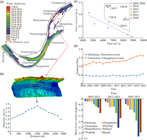
The planned channel size of the Jingjiang reach is 4.5 × 200 × 1050 m, which allows 5000-t vessels to navigate. The maximum velocity of 5000-t vessels in shoals of the mainstream of the Yangtze River is 2.8 m/s, and the maximum ratio is 0.8%. From 2005 to 2018, the maximum flow velocity in the reach from Zhicheng to Changmenxi reach increased significantly, reaching a maximum of 3.50 m/s. In 2020, the maximum flow velocity decreased to 3.28 m/s (Figure 6a,c), which, however, is still not conducive to the safe navigation of vessels. The vertical gradient from Zhicheng to Chenerkou reach is relatively small but increases significantly from Chenerkou to Changmenxi reach. Owing to a reduction in the flow of the Songzikou diversion area, the increase in the ratio of the current distribution of the right branch of the Lujiahe reach caused significant erosion of the branch channel, resulting was weak hydrodynamic force was the left branch. In addition, the water depth of the channel is less than 4.5 m, and the width is less than 200 m (Figure 6b). As the riverbed of the right branch had greater resistance to erosion than that in the lower reaches, that is, there was a drop in the water level, the gradient of the Changmenxi–Dabujie reach was greater than 0.8% (Figure 6d). Consequently, the phenomenon of a steep slope and rapid current remained, which was not conducive to the safe navigation of the vessels. Moreover, from 2003 to 2021, the Zhicheng–Changmenxi reach demonstrated the same flow (the flow at Yichang station was 6000 m3/s) and the low-water level indicated a cumulative downward trend. The cumulative water level drops for Zhicheng, Chenerkou, Maojiahuawu, Yaogang, and Changmenxi were 0.46, 0.59, 0.93, 0.97, and 1.19 m, respectively (Figure 6e). Recently, the intensity of scouring and silting of sand and pebbles on the riverbed has weakened (S. X. Li, Yang, et al., 2021; Y. P. Yang, Zhang, Zhu, et al., 2018; Y. P. Yang, Zhang, Sun, et al. 2018). Moreover, coarsening of the riverbed during scouring and silting (Y. P. Yang et al., 2016; Y. P. Yang, Zhang, Sun, Han, et al., 2018) has reduced the downward trend of the water level (Chai et al., 2020; J. Q. Han, Sun, et al., 2017; Y. P. Yang, Zhang, Sun, Han, et al., 2018) to a considerable degree; however, a falling water level is not conducive to a stable waterway depth during low-water periods (Yan et al., 2019; Y. Yang et al., 2019). Obstructed navigation in the Songzikou diversion area can be summarized as the cumulative decline in the low-water level, which is not conducive to the maintenance and improvement of the waterway dimensions. Furthermore, the characteristics of a steep slope and fast current detrimentally affect safe navigation.
4.1.2 Influence of channel runoff and sandbank along with tidal flat shape on channel conditions
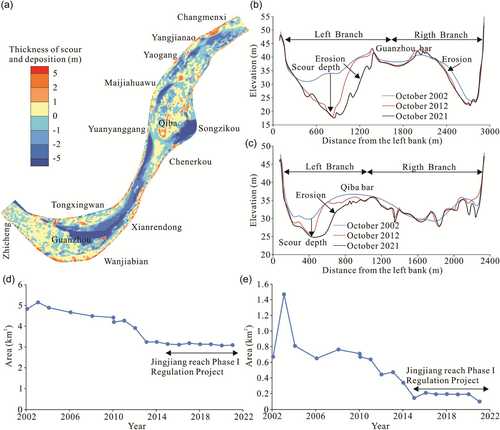
The length of the connecting section between the Guanzhou and Lujiahe branches was approximately 8000 m, with mountains and stable shorelines on the right and left banks, respectively. Existing studies assert that the Guanzhou and Lujiahe branches evolved independently, with the connecting section conforming to the basic characteristics of barrier rivers (You et al., 2016; You, Tang, Zhang, Hou, et al., 2017; You, Tang, Zhang, Yang, et al., 2017). Here, no significant correlation was observed between the shape of the beach and the diversion ratio of the branch channel. From 1960 to 2002 and from 2003 to 2021, the flow of the Songzikou diversion was 41.4 × 10⁹ and 30.8 × 10⁹ m3/year, respectively, and the ratio of current distribution was 9.3% and 7.1%, respectively. Comparing the periods 2003–2017 and 1984–2002, the ratio of the current distribution of the Guanzhou right branch corresponding to 6000, 10,000, and 20,000 m3/s at Zhicheng station, that is, a decrease by 5.6%, 4.0%, and 2.4%, respectively (Table 3). Comparing the periods 2008–2017 and 2003–2007, the ratio of the current distribution of the Guanzhou right branch corresponding to 6000, 10,000, and 20,000 m3/s at Zhicheng station, that is, they decreased by 2.8%, 3.3%, and 3.5%, respectively (Table 4). Owing to a decrease in the flow of the Songzikou diversion and a relative increase in the flow of the Jingjiang reach, the weak erosion resistance of the left branch of the Lujiahe caused erosion, consequently, resulting in scouring in the branch channel (Figure 7a–c). Subsequently, it led to a decrease in the same flow ratio of the current distribution of the Lujiahe reach left branch. The same flow ratio of the current distribution of the Guanzhou left branch and Lujiahe reach right branch increased. However, the increase in the ratio of the current distribution of the branches with short flow paths was a common phenomenon. The first phase of the waterway improvement project in the middle reaches of the Yangtze River from Yichang to Changmenxi was implemented from October 2014 to September 2016. Thus, the ratio of the current distribution of the Lujiahe left branch increased by 11.1%. The implementation of the project played a positive role in reducing the erosion of the right branch and reducing the ratio of the current distribution of the left branch. In addition, from 2002 to 2021, the areas of the mid-channel bars at Guanzhou and Qiba decreased. Since the implementation of the first phase of the waterway improvement project in the middle reaches of the Yangtze River from Yichang to Changmenxi in 2014, the areas of the mid-channel bars have been relatively stable (Figure 6d,e). Studies have proven that the reduced size of the mid-channel bar has increased the swing space of the upper mainstream, which is not conducive to stabilizing the relationship between branches and diversions (J. Q. Han et al., 2018; Y. P. Yang, Zheng, Zhang, Zhu, Zhu, et al., 2021; Zhao et al., 2020). A comprehensive analysis indicated that the increase in the ratio of the current distribution of the Guanzhou and Lujiahe branches in the Songzikou diversion area during the low-water period was not conducive to stabilizing the ratio of the current distribution of the main channel. Moreover, the shrinking of sandbanks and tidal flats and the reduction in the Songzikou diversion flow has further accelerated the development of the Guanzhou and Lujiahe branches during the low-water period, caused by a relative increase in diverted flow.
| Time (year-month) | Flow (m3/s) | Split ratio (%) | Time (year-month) | Flow (m3/s) | Split ratio (%) | ||
|---|---|---|---|---|---|---|---|
| Left branch | Right branch | Left branch | Right branch | ||||
| 1984-07 | 36,800 | 60.0 | 40.0 | 2003-03 | 4232 | 19.1 | 80.9 |
| 1984-11 | 5490 | 19.3 | 80.7 | 2004-02 | 4376 | 19.3 | 80.7 |
| 1985-08 | 19,940 | 470 | 53.0 | 2007-11 | 8042 | 37.8 | 62.2 |
| 1985-10 | 15,500 | 43.0 | 57.0 | 2008-03 | 4566 | 23.6 | 76.4 |
| 1986-08 | 20,040 | 49.0 | 51.0 | 2009-02 | 7080 | 31.4 | 68.6 |
| 1986-11 | 10,140 | 38.0 | 62.0 | 2010-12 | 6025 | 29.6 | 70.4 |
| 1987-08 | 27,000 | 53.0 | 47.0 | 2012-11 | 6027 | 34.1 | 65.9 |
| 1987-11 | 9850 | 32.1 | 67.9 | 2013-02 | 6098 | 26.7 | 73.3 |
| 1988-01 | 4314 | 14.9 | 85.1 | 2013-11 | 8677 | 40.1 | 59.9 |
| 1988-12 | 4900 | 21.6 | 78.4 | 2016-04 | 12,077 | 38.7 | 61.3 |
| 1996-01 | 4740 | 23.8 | 76.2 | 2017-01 | 6404 | 24.1 | 75.9 |
| 1999-01 | 4527 | 8.5 | 91.5 | 2017-08 | 18,576 | 49.9 | 50.1 |
| Time (year-month) | Flow (m3/s) | Split ratio (%) | Time (year-month) | Flow (m3/s) | Split ratio (%) | ||
|---|---|---|---|---|---|---|---|
| Left branch | Right branch | Left branch | Right branch | ||||
| 2003-03 | 4070 | 71.9 | 28.1 | 2007-11 | 7951 | 43.7 | 56.3 |
| 2004-02 | 4398 | 65.2 | 34.8 | 2008-08 | 4545 | 59.8 | 40.2 |
| 2005-03 | 6034 | 59.1 | 40.9 | 2009-02 | 7022 | 52.5 | 47.5 |
| 2006-02 | 4191 | 60.7 | 39.3 | 2010-12 | 6020 | 55.0 | 45.0 |
| 2006-03 | 5523 | 53.2 | 46.8 | 2012-11 | 5971 | 51.4 | 48.6 |
| 2006-03 | 6510 | 53.2 | 46.8 | 2013-02 | 6246 | 52.0 | 48.0 |
| 2006-03 | 7412 | 50.8 | 49.2 | 2014-02 | 6058 | 50.2 | 49.8 |
| 2006-04 | 8294 | 50.9 | 49.1 | 2017-01 | 6347 | 50.0 | 50.0 |
| 2007-03 | 5252 | 61.0 | 39.0 | ||||
4.2 Navigation obstructions and influencing mechanisms at Taipingkou waterway
The Taipingkou waterway represents the Taipingkou diversion area reach, which has numerous point and mid-channel bars in the waterway with strongly correlated evolution (Y. P. Yang, Zheng, Zhang, Zhu, Chai, et al., 2021; Zhao et al., 2020). After the TGP came into operation, water and sediment conditions changed significantly. In addition, channel conditions became more dependent on the morphology of sandbanks and tidal flats, the stability of branch diversions, and the ability to maintain channels. From 2003 to 2021, the low-water level of Dabujie and Shashi (flow rate of 6000 m3/s at Yichang Station) dropped by a total of 3.29 and 2.94 m, respectively (Figure 6e). Accordingly, the depth of the waterway in the Taipingkou waterway continued to decrease owing to the drop in the low-water level.
4.2.1 Influence of sandbank and tidal flat changes on channel conditions
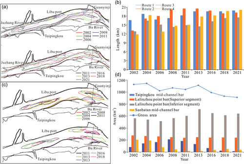
The target water depth of the Jingjiang reach phase two project was 4.5 m, and the water depth was checked to ensure it is under the minimum water level of 4.5 m (Figure 8a,b). The results demonstrated some improvement in the water depth of the Taipingkou south channel–Sanbatan south branch (Route 1) and the Taipingkou south channel–Sanbatan north channel (Route 2). By 2013, a 4.5-m depth contour connected the Taipingkou south channel and the Sanbatan south branch. From 2008 to 2013, a 4.5-m depth contour connected the Taipingkou south channel and the Sanbatan north channel. Since 2016, the routes have been disconnected. From 2002 to 2018, the water depth conditions of the Taipingkou north channel–Sanbatan north branch (Route 3) were poor, but the conditions of the 4.5 m Taipingkou north channel–Sanbatan south branch (Route 4) waterway improved gradually. This was mainly related to the improvement in the water depth of the Taipingkou north channel. From 1955 to 1975, the flow and the ratio of the current distribution of the Taipingkou diversion fluctuated. During this period, the Lalinzhou beach point bar was relatively large, and the Taipingkou mid-channel bar had not formed yet (J. Fang et al., 2022; Y. P. Yang, Zheng, Zhang, Zhu, Zhu, et al., 2021; Zhao et al., 2020). The flow of the Taipingkou diversion decreased by 29.3% from 1975 to 1993 compared with that from 1955 to 1975, thereby causing a relative increase in the runoff of the Jingjiang reach. Additionally, the upper segment of the Lalinzhou point bar was washed away, and the formation of the Taipingkou mid-channel bar was formed (J. Fang et al., 2022; Y. P. Yang, Zheng, Zhang, Zhu, Zhu, et al., 2021; Zhao et al., 2020). From 2002 to 2008 (Figure 8c,d), the middle and upper sections of the Lalinzhou point bar were eroded and it retreated, causing a corresponding increase in the mid-channel bar area at Taipingkou, significant reduction in the Sanbatan area, erosion of the upper section of the Lalinzhou point bar, and siltation at the lower section. From 2008 to 2018, the Taipingkou mid-channel bar area and Sanbatan decreased, and the upper section of the Lalinzhou point bar was stable, whereas the lower section increased. Overall, although several phases of waterway improvement projects were implemented in the Taipingkou waterway after the TGP became operational, the area of sandbars and tidal flats still decreased, which was not conducive to the stability of waterway boundary conditions.
4.2.2 Influence of channel runoff on channel conditions
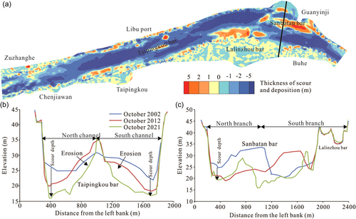
From 2001 to 2010 and 2010 to 2018, the ratio of the current distribution of the Taipingkou mid-channel bar and branch initially decreased and gradually increased further. From 2004 to 2006, alternation occurred in low-water branches. Since 2006, the ratio of the current distribution of the Taipingkou mid-channel bar south channel during the low-water period has been higher than 50%, with the main channel being the Taipingkou mid-channel bar south channel (Table 5). During the periods from 2002 to 2012 and till 2021, the north and south channels of the Taipingkou mid-channel bar eroded, with a significant scouring of the Sanbatan beach. The two branches exhibited significant imbalance, with the erosion intensity of the southern branch being higher than that of the northern branch (Figure 9a). The erosion of the north channel was greater than that of the south channel, and the two sides of the mid-channel bar demonstrated an erosive trend. Since 2012, owing to the unbalanced erosion of the north and south channels of the Taipingkou mid-channel bar, and the influence of sand mining, the ratio of the current distribution of the north channel of the mid-channel bar increased. From 2001 to 2010 and 2010 to 2018, the ratio of the current distribution of the south branch of Sanbatan first decreased and then increased, becoming relatively stable between 2015 and 2018 (Figure 9b). From 2010 to 2011, an alternation of branch channels occurs during the low-water period at Sanbatan. During the periods from 2002 to 2012 till 2021, the north branch of Sanbatan became eroded. In addition, the south branch was first subjected to erosion and then siltation, causing the Sanbatan to erode severely, with its position shifting to the left, forming the new-Sanbatan (Figure 9c and Table 5).
| Time (year-month) | Flow (m3/s) | Split ratio of Taipingkou branch (%) | Split ratio of Sanbatan branch (%) | ||
|---|---|---|---|---|---|
| Left branch | Right branch | Left branch | Right branch | ||
| 2001-02 | 4370 | 68.0 | 32.0 | 43.0 | 57.0 |
| 2001-11 | 12,600 | / | / | 30.0 | 70.0 |
| 2002-01 | 4560 | 59.0 | 41.0 | 35.0 | 65.0 |
| 2002-11 | 7469 | / | / | 28.0 | 72.0 |
| 2003-11 | 14,904 | 60.0 | 40.0 | 36.0 | 64.0 |
| 2003-03 | 3728 | 55.0 | 45.0 | 27.0 | 73.0 |
| 2003-05 | 10,060 | 65.0 | 35.0 | 42.0 | 58.0 |
| 2003-12 | 5474 | 56.0 | 44.0 | 34.0 | 66.0 |
| 2004-01 | 4842 | 52.0 | 48.0 | 32.0 | 68.0 |
| 2004-11 | 10,157 | 48.0 | 52.0 | 35.0 | 65.0 |
| 2005-11 | 8703 | 45.0 | 55.0 | 45.0 | 55.0 |
| 2006-09 | 10,300 | 51.0 | 49.0 | 42.0 | 58.0 |
| 2007-03 | 4955 | 47.0 | 53.0 | 56.0 | 54.0 |
| 2009-02 | 6907 | 38.0 | 62.0 | 43.0 | 57.0 |
| 2010-03 | 6000 | 35.0 | 65.0 | 41.0 | 59.0 |
| 2011-02 | 5933 | 38.6 | 61.4 | 59.4 | 40.6 |
| 2012-02 | 6233 | 37.4 | 62.6 | 67.8 | 32.2 |
| 2013-02 | 6130 | 42.0 | 58.0 | 61.0 | 39.0 |
| 2014-02 | 6200 | 42.0 | 58.0 | 36.0 | 64.0 |
| 2014-12 | 7000 | 40.3 | 59.7 | 15.1 | 84.9 |
| 2015-12 | 6650 | 44.3 | 59.7 | 15.1 | 84.9 |
| 2016-11 | 8100 | 41.6 | 58.4 | 21.3 | 78.7 |
| 2017-03 | 7300 | 40.7 | 59.3 | 21.7 | 78.3 |
| 2017-11 | 9800 | 42.5 | 57.5 | 17.8 | 82.2 |
4.3 Navigation obstructions and influencing mechanisms at Ouchikou
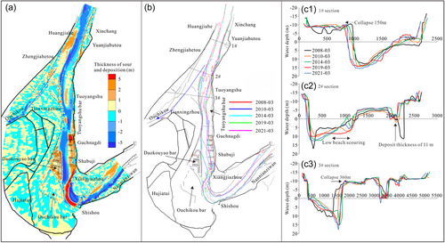
With the decrease in the Ouchikou diversion, the relative increase in the runoff of the Jingjiang reach caused the collapse of the right edge of Tianxingzhou and the erosion of the upper section of the Tuoyangshu point bar, consequently affecting channel conditions in the downstream reaches directly (Figure 10a,b). Since 2003, the collapse of the right edge of Tianxingzhou pronounced significantly. During the first phase of the waterway improvement of the Jingjiang reach, the shoreline was protected, but the unprotected area remained in a state of collapse. An approximately 360-m-long section collapsed between 2016 and 2019 (Figure 10c). From 2003 to 2019, the upper section of the Tuoyangshu point bar eroded and the lower section expanded owing to siltation. Moreover, the squeezing of the navigation channel led to the relatively obvious collapse of the Daokouyao mid-channel bar. From 2013 to 2017, the first phase of the waterway improvement project of the Jingjiag reach was implemented, in which the middle and lower sections of the Tuoyangshu point bar and the Daokouyao mid-channel bar were protected. However, the middle and upper sections of the Tuoyangshu point bar that were not protected remained in a state of erosion and retreat, with the eroded sediment moving downstream and accumulating in the navigation channel to form a silt body that obstructed navigation. From 2017 to 2018, the erosion of the riverbed in the Xinchang–Guchangdi reach was approximately 7.92 × 10⁶ m3, and the sediment transported downstream was deposited in the Ouchikou reach, which required dredging and maintenance (Y. J. Fan, Yang, et al., 2020; W. T. Fan, Chen, et al., 2020). The decrease in flow at the Ouchikou diversion has exacerbated the collapse of the shoreline of the Ouchikou reach and the retreat of the point bar (Jia et al., 2016). The obstruction of navigation is ascribed to the instability of the channel boundary, and the silt body formed by erosion has caused the downstream water depth to fall below 4.5 m, with the width being less than 200 m.
4.4 Navigation obstruction and influencing mechanisms of Dongting Lake confluences
4.4.1 Influence of riverbed erosion and deposition on channel conditions
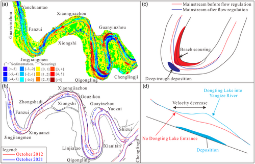
The continuous curved river has wandering characteristics, and the plane position of the river changes greatly (Ferdoush et al., 2022). From 2012 to 2021, the Xiongjiazhou–Chenglingji reach in the inflow area of Dongting Lake was characterized by “scouring of point bars on the convex bank, and sedimentation of the river channel on the concave bank” (Figure 11a). This finding was consistent with the distribution characteristics observed from 2002 to 2012 (Zhu et al., 2016, 2018). Under the effect of the regulation of the TGR, the reallocation of the flow of the lower Jingjiang reach during the year caused a longer duration of the convex bank point bar located in the mainstream compared with that of the deep channel of the concave bank, increasing the erosive power of the point bar (J. Q. Han, Zhang, et al., 2017). The erosion of the point bar of the convex bank at the curved river section caused the curvature radius of the waterway to decrease, thus hindering the safe navigation of ships. The Xiongjiazhou–Chenglingji reach is a continuous sharp bend, and thus Xiongjiazhou, Qixingzhou, Baxingzhou, and Guanyinzhou are affected by the jacking role of outflow from Dongting Lake (Lai et al., 2013; Sun et al., 2017). In 2012, the 4.5-m channel in the confluence area of Dongting Lake and the Jingjiang reach was severed. Once the TGR was commissioned, the intensity of the mutual hydrological jacking effect in the river–lake confluence area was weakened (Duan et al., 2019; D. D. Yu et al., 2017; M. Zhang et al., 2015). In 2021, a 4.5-m channel was established in the river–lake confluence area, but scattered sand bars with depths of less than 4.5 m appeared, leading to insufficient width for navigation (Figure 11b–d).
4.4.2 Influence of confluence relationships on channel conditions
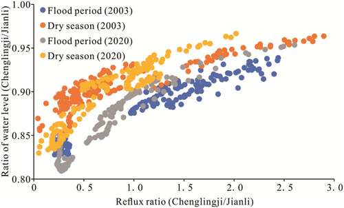
Based on the measured water levels and flow data from the Jianli and Chenglingji hydrological stations in 2003 and 2020, we analyzed the jacking effect of the inflow water body of Dongting Lake on the mainstream of the Yangtze River.
 ) is the flow ratio at the Chenglingji station (QChenglingji) and the Jianli station (QJianli), and can be calculated as follows:

 represents the water level ratio at Chenglingji station (HChenglingji) and Jianli station (HJianli) and can be calculated as follows:

The relationships between the flow and water levels at Jianli and Chenglingji stations in 2003 and 2020 showed an increase in water level along with an increase in the confluence ratio (Figure 12). Comparing 2020 with 2003, under the same confluence ratio, the water level ratio increased, indicating a weakening of the jacking role of the outflow of Dongting Lake on the water level of the mainstream. The relatively weakened jacking effect of Dongting Lake on the water level of the mainstream of the Yangtze River, and the weakening of the damming of the mainstream owing to the Dongting Lake confluence were conducive to improving the water depth for a 4.5-m navigation channel between Xiongjiazhou and Chenglingji reach.
4.5 Analysis of waterway governance measures
As of December 2021, 500 channel improvement structures have been implemented on the Yangtze River mainline. For example, the implementation of channel projects using advanced channel management technology in the Jingjiang reach, Wuhan to Anqing reach, and below Nanjing has resulted in an increase in the depth of the waterways from 3.2 to 3.8, 4.5 to 6.0, and 10.5 to 12.5 m, respectively (L. S. Liu, Li, et al., 2017; H. H. Liu, Yang, et al., 2017; Y. Yang et al., 2019). Waterway regulation projects have been systematically implemented on the Yangtze River trunk line using various environmentally friendly structures, including tetrahedral frames (K. Wang, Guo, et al., 2017; Xing et al., 2021), dolosse (Cao et al., 2018), W-shaped dams (Huang et al., 2019), “fish tank” bricks (Cao et al., 2018), D- and X-shaped rows, and grass-planting and sand-fixing structures (Y. J. Fan, Yang, et al., 2020; W. T. Fan, Chen, et al., 2020). According to long-term observations since 2013, these structures have had a significant positive effect on the ecological environment of the Yangtze River (T. H. Li et al., 2018). Onsite monitoring results have revealed that after the implementation of the first-phase project of the Jingjiang reach, vegetation in the high beach increased considerably. For example, the Daokouyao mid-channel bar has gradually transformed from a bear bare into a lush-vegetation area, and the growth of vegetation effectively stabilized the beach. Fish abundance near the constructions has also increased, and benthos has been recovered (N. Liu et al., 2021). The ecological restoration measures adopted by the waterway channel project at a depth of 12.5 m below Nanjing, including artificial fish nests and ecological floating beds, have shown significant effects because the floating bed plants have been significantly growing and the number of planktons in fish nests has been increasing (Cao et al., 2018).
The development of shipping functions is an important aspect of watershed resource utilization. However, the use of natural scouring alone to deepen waterways is associated with great uncertainty, and the water depth that can be obtained in this way has a certain limit. Waterway expansion is needed to meet the growing demands of shipping. The expansion is often implemented through the construction of reservoirs (Y. Yang et al., 2019), spur dikes (Y. Yang et al., 2019), canalized rivers (Wan et al., 2014; S. H. Wu et al., 2016), and dredging (Hajdukiewicz et al., 2016; Suedel et al., 2021). The major obstacles to navigation in the Guanzhou–Lujiahe reach are the drop in water level, steep slopes, and rapid currents. Thus, it is recommended that the measures taken should combine dredging and regulation, stabilize the control of the Lujiahe reach on the water level drop, and integrate dredging and trench filling to alleviate steep slopes and rapid flows. We found that the deformation of the beach in the Taipingkou channel was still relatively large, and the linkage between the upper and lower beaches existed. Engineering measures should be implemented to control the position and shape of the Taipingkou mid-channel bar and further stabilize the shape of the Sanbatan mid-channel bar. The problem of navigation obstruction in the Ouchikou waterway was that the boundary of the beach was still unstable; therefore, the boundary control of Tuoyangshu point bar and the right edge of the Tianxingzhou mid-channel bar should be strengthened. Lastly, for the section from Xiongjiazhou to Chenglingji reach, it is recommended to strengthen shoreline control, maintain a stable river condition, and implement dredging measures to maintain the passage of the channel.
5 CONCLUSIONS
- (1)
Since the operation of the TGP (2003–2021), the accumulative scouring amount of flat bars channel in the Jingjiang reach of the middle reaches of the Yangtze River has been 1.266 × 10⁹ m3, and the scour proportion of dry river channel has been 91.12%. Channel erosion provided favorable conditions for the improvement of channel conditions, and the decrease in the volume of sediment entering the middle and lower reaches of the Yangtze River contributed to the stability and improvement of channel conditions.
- (2)
The length of the Jingjiang reach in the middle reaches of the Yangtze River that does not meet the required dimensions of 4.5 × 200 m was 18.4 km. The stretches of the Songzikou (from Guanzhou–Lujiahe reach), Taipingkou (from Taipingkou–Sanbatan reach), and Ouchikou (from Zhougongdi–Ouchikou reach) divergence areas and the outlet of Dongting Lake (from Xiongjiazhou–Chenglingji reach) that hinder a total navigation of 12.6 km.
- (3)
The reach affected by the first Dongting Lake diversion showed a notable phenomenon of “steep slope and rapid flow,” which affects the safe navigation of vessels. In addition, downstream riverbed erosion caused the water level to drop, with the water depth of the channel being below 4.5 m. Moreover, the reach affected by the second diversion exhibited sandbank and tidal flat shrinkage, frequently alternating branches, and extremely unstable low-water routes. The reach affected by the third diversion suffered shoreline collapse, as well as point bar erosion and migration. Furthermore, the instability of the channel boundary implied that the downstream navigation width was insufficient or led to the water depth to fall below 4.5 m. The reach affected by the Dongting Lake inflows was subject to the jacking effect of the outflow of the lake. Furthermore, the flow in this reach created scattered shoals, with a water depth of less than 4.5 m in the navigation waterway.
ACKNOWLEDGMENTS
This study was funded by the National Key Research and Development Program of China (2021YFB2600500), the National Natural Science Foundation of China (52279066), and the Special Scientific Research Project of Changjiang Waterway Regulation (SXHXGZ-2022-1).
Open Research
DATA AVAILABILITY STATEMENT
The data and code for this study are available upon request from the corresponding authors. Data are available on request due to privacy/ethical restrictions.
None declared.


