

Journal list menu

 Issue
IssueEarth Surface Processes and Landforms: Volume 49, Issue 8
2309-258230 June 2024
Export Citations
Download PDFs
ISSUE INFORMATION
RESEARCH ARTICLES
Groundwater-surface water interaction, dissolved organic carbon oxidation and dissolution in carbonate aquifers
- Pages: 2311-2325
- First Published: 03 April 2024
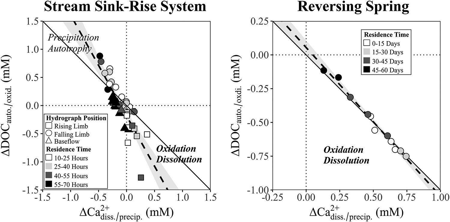
Significant (p < 0.01) inverse linear relationships between losses of dissolved organic carbon and gains of calcium at two distinct locations in north-central Florida describe linkages between organic carbon oxidation and dissolution. Slopes of these relationships indicate variable subsurface residence times alter the extent of each reaction magnitude. Results point out the role of groundwater-surface water interactions in carbon cycling in carbonate aquifers.
A 121-ka record of Western Andean fluvial response to suborbital climate cycles recorded by rhythmic grain size variations of the Lima fluvial fan
- Pages: 2326-2347
- First Published: 04 April 2024
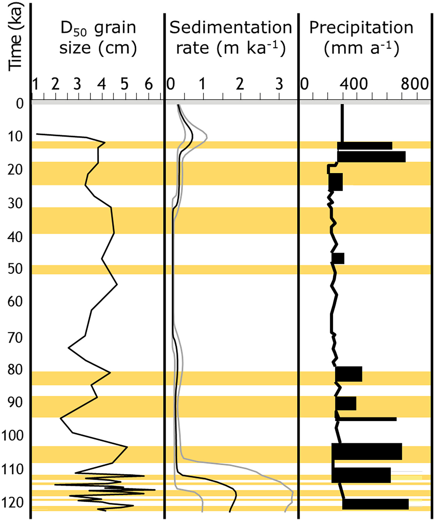
Our study presents a detailed stratigraphic analysis of the Lima fluvial fan, offering the most complete, last glacial alluvial record to date for the Peruvian Andes. Using grain size analysis and luminescence dating, three major sedimentation periods containing numerous coarsening upward sequences were identified and correlated with suborbital pluvial periods. The findings suggest that suborbital, rather than orbital, climate variability was the primary driver of sedimentation, providing new insights into the formation of the geological substrate beneath Peru's capital city.
Synergistic process interactions and morphological change in a river reach subject to multiple disturbances, the Laja River, Chile
- Pages: 2348-2366
- First Published: 03 April 2024
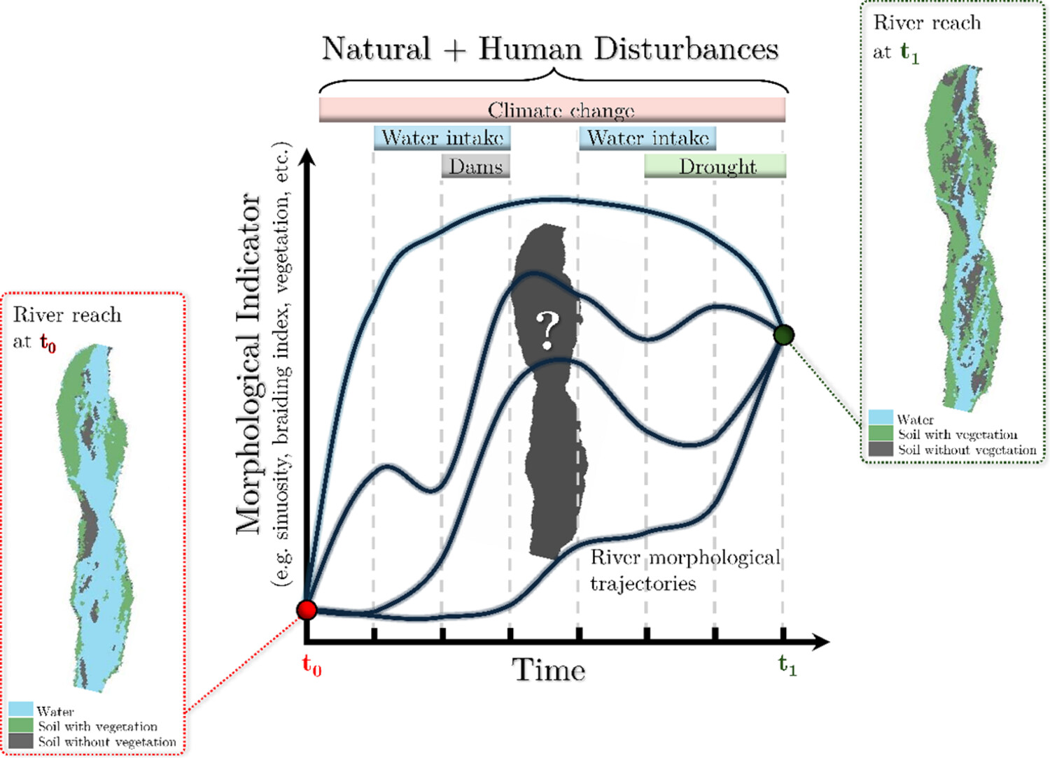
Natural and human disturbances, such as climate change, water intakes, dam operations, and droughts impact river morphology over time. A river can transition from one state to another, following one of various possible morphological trajectories. This process is evident in the Laja River (Chile), where satellite images show a transformation from a single-channel to a braided river over 15 years, driven by hydroelectric plant operations, irrigation withdrawals, and reduced rainfall.
The applicability of automated marine clay gully delineation using deep learning in Norway
- Pages: 2367-2379
- First Published: 28 April 2024
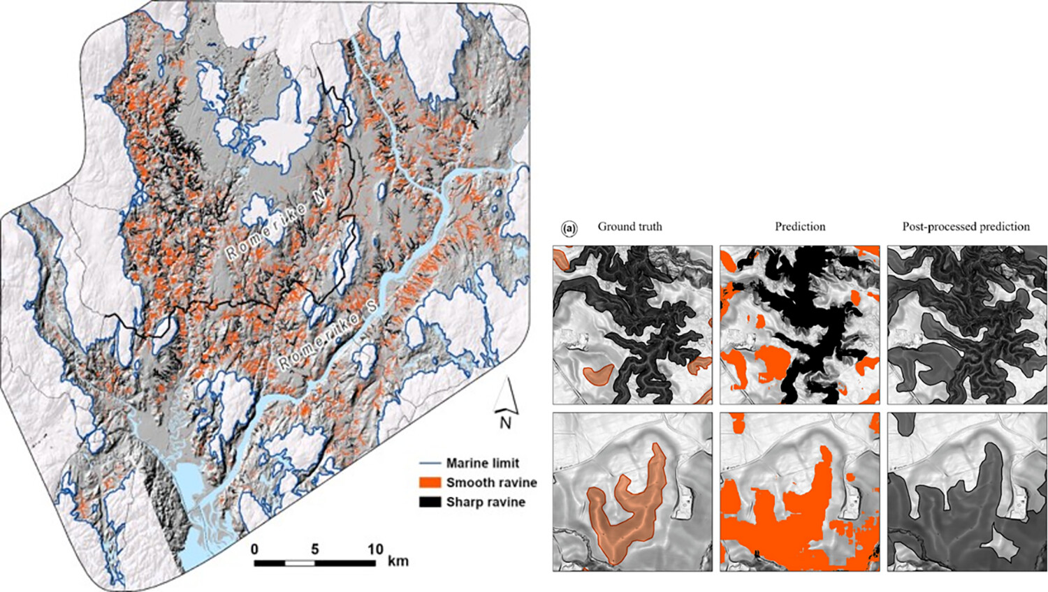
Gullies and ravines are common and important landforms in raised marine fine-grained deposits in Norway. We explore the applicability of automated approaches of combining deep learning (DL) and U-Net model with ArcPy libraries to derive a map of impacted and intact gullies. The applicability increases when the predictions are post-processed by combining ensembled models followed by eliminating noise. The outcome contributes towards mapping the spatial extent of red-listed landforms and the development of monitoring systems for future landscape change.
UAV-SfM-based field quantification of barchan dune celerity and morphodynamics in Gonghe Basin
- Pages: 2380-2404
- First Published: 19 April 2024
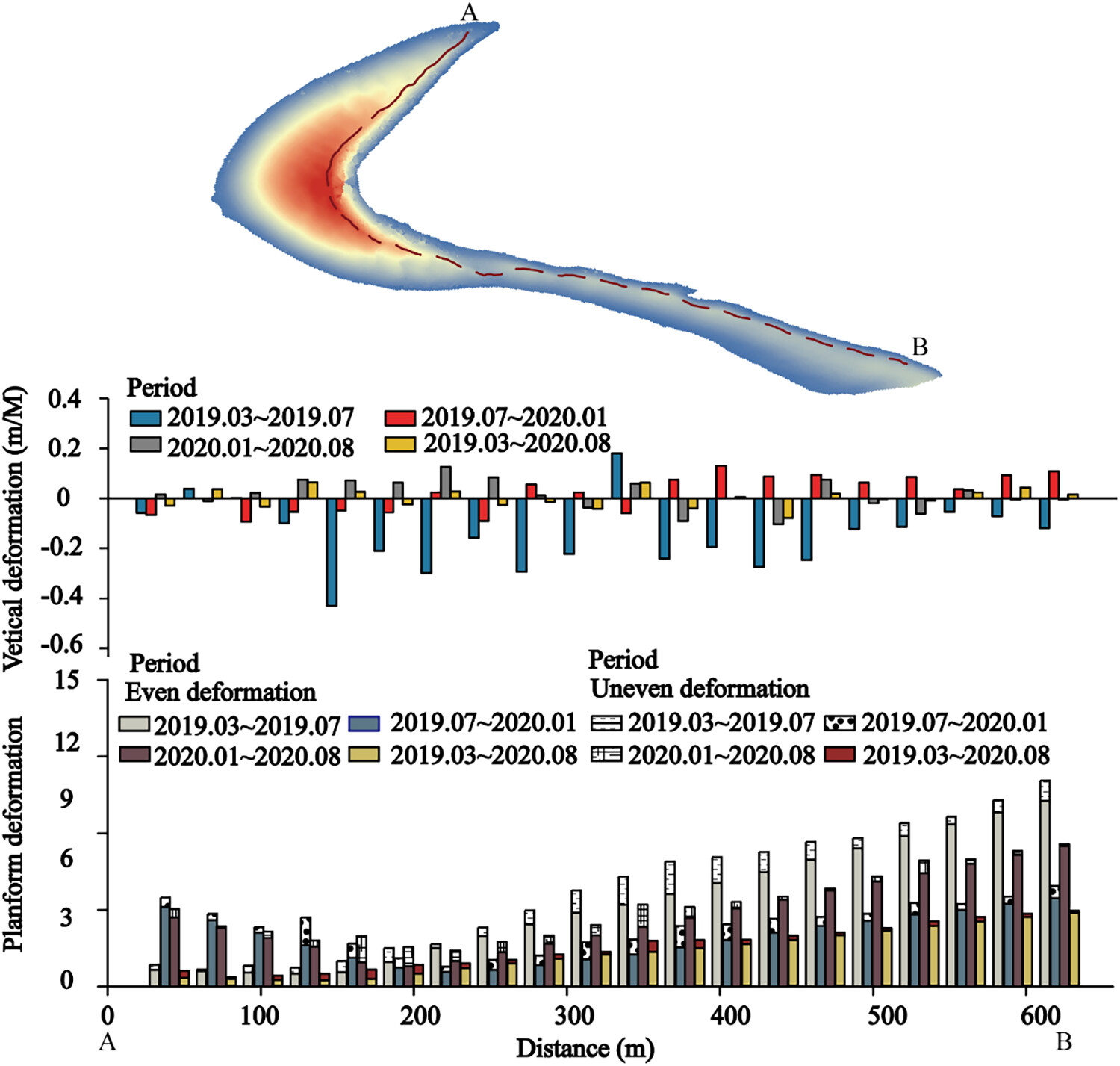
Celerity and deformation of barchan dunes distributed in Ertala, Gonghe Basin were monitored to help us to further understand the morphologic dynamics of dunes coexisting with the grassland landscape at high-altitude. Symmetry plays an important role in deformation, while that has no obvious influence on celerity. Sand supply, vegetation and airflow all influence the celerity and deformation of barchan dunes. Asymmetric bidirectional winds, asymmetric inflow and interaction between dunes account for the formation of asymmetric dunes in this area.
VedgeSat: An automated, open-source toolkit for coastal change monitoring using satellite-derived vegetation edges
- Pages: 2405-2423
- First Published: 14 May 2024
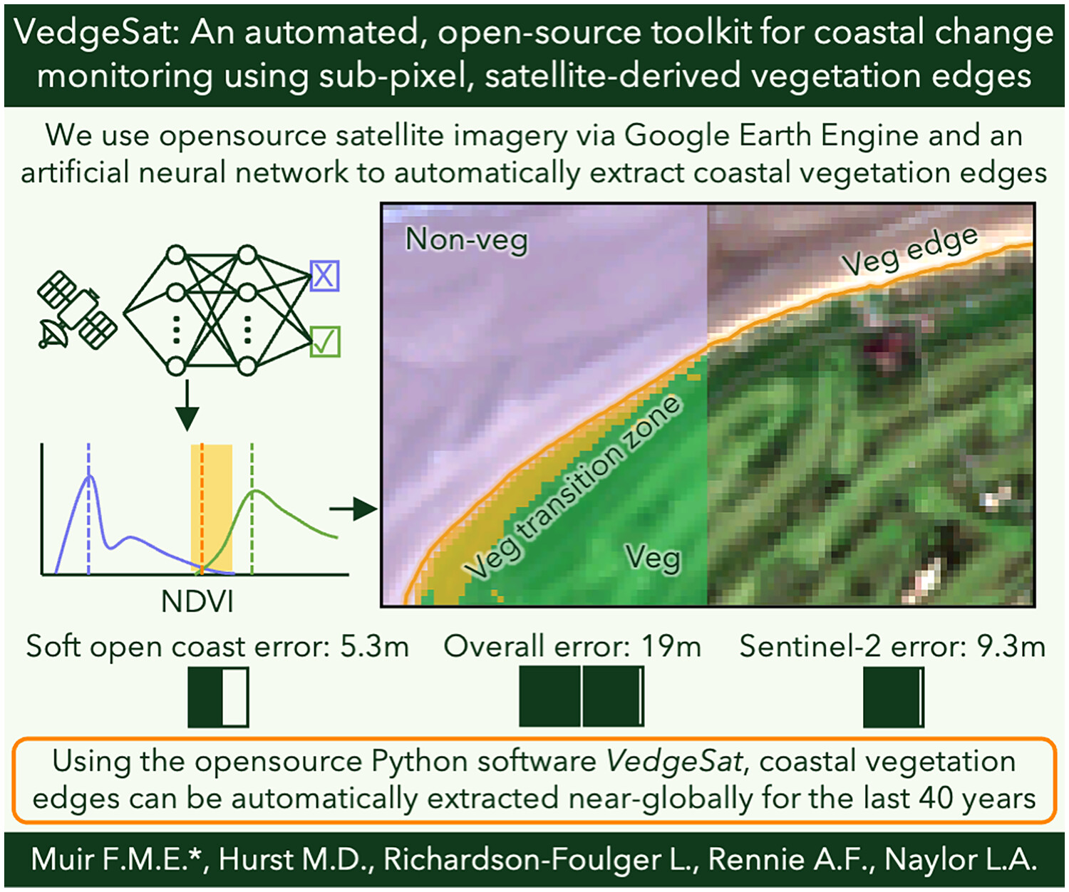
We use open-source satellite imagery via Google Earth Engine and an artificial neural network to automatically extract coastal vegetation edges. Using the open-source Python software VedgeSat, coastal vegetation edges can be automatically extracted near globally for the last 40 years.
Precipitation adjustment by the OTT Parsivel2 in the central Qinghai–Tibet Plateau
- Pages: 2424-2441
- First Published: 20 April 2024
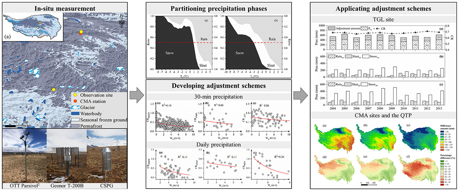
Based on the measurements of two sites on the central QTP, the precipitation adjustment schemes were proposed for 30-min and daily measurements. The proposed adjustment schemes were applied and assessed at the TGL site and the entire QTP, respectively. The increasing rate was higher on the central than the QTP average and higher in wet seasons than cold seasons on the central QTP.
Differences in sediment provenance from rainfall and snowmelt erosion in the Mollisol region of Northeast China
- Pages: 2442-2457
- First Published: 24 April 2024
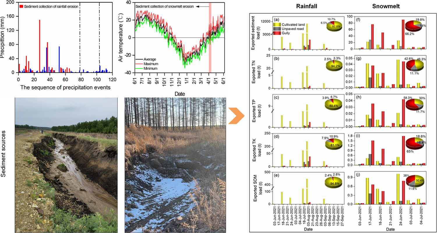
This research determined sediment provenance of rainfall and snowmelt erosion in the Mollisol region of Northeast China. Sediment contributions showed different patterns between rainfall and snowmelt erosion. In the rainy season, cultivated land was the primary contributor to suspended sediment, whereas gullies were the primary contributor in the spring thaw period.
Structural shifts in plant functional diversity during biogeomorphic succession: Moving beyond taxonomic investigations in an alpine glacier foreland
- Pages: 2458-2474
- First Published: 11 April 2024
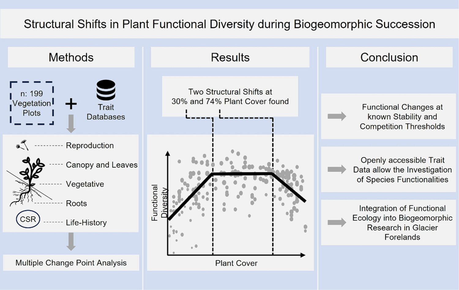
This study indicates functional changes of alpine plants at known stability and competition thresholds during biogeomorphic succession in glacier forelands, utilizing openly accessible trait data. Unlike earlier studies that focused predominantly on taxonomic analyses of biogeomorphic succession, this research underscores significant shifts in the dominance of certain traits during this process.
Inferring channel incision in gravel-bed rivers: Integrating LiDAR data, historical aerial photographs and drone-based SfM topo-bathymetry
- Pages: 2475-2497
- First Published: 16 April 2024
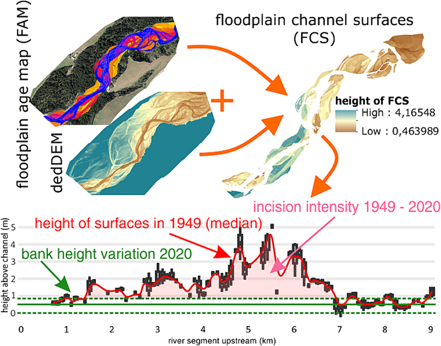
The paper presents an innovative approach to assess the multidecadal incision since 1949 by LiDAR-based analyses of floodplain surfaces above the river channel dated from historical aerial images. Detailed analyses of ongoing incision were also calculated based on DEM of differences (DoD) using structure-from-motion (SfM) photogrammetry-derived topo-bathymetric models.
Observations and computational multi-phase modelling in tropical river settings show complex channel changes downstream from rainfall-triggered landslides
- Pages: 2498-2516
- First Published: 10 April 2024
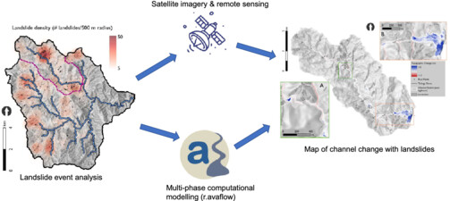
The Antamok River (Philippines) was affected by more than 500 landslides during Typhoon Mangkhut in September 2018. Landslide mapping using satellite imagery and remote sensing, together with multi-phase computational modelling, highlighted key areas of erosion and deposition in the catchment, which could not be represented by traditional approaches such as unit stream power threshold.
Improving predictions of critical shear stress in gravel bed rivers: Identifying the onset of sediment transport and quantifying sediment structure
- Pages: 2517-2537
- First Published: 18 April 2024
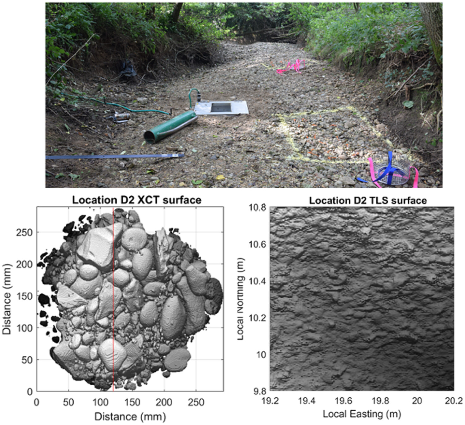
We review recent advances in monitoring bedload transport and in quantifying sediment structure and show how they offer new opportunities to improve predictions of critical shear stress. As illustration, we compare three methods to measure a range of parameters that describe grain-scale sediment structure: direct field measurements, terrestrial laser scan data and CT scan data. Measurements of grain size are comparable between methods, but measurements of grain protrusion and fine-grained matrix are more variable.
Riverine aquatic plants trap propagules and fine sediment: Implications for ecosystem engineering and management under contrasting land uses
- Pages: 2538-2551
- First Published: 17 April 2024
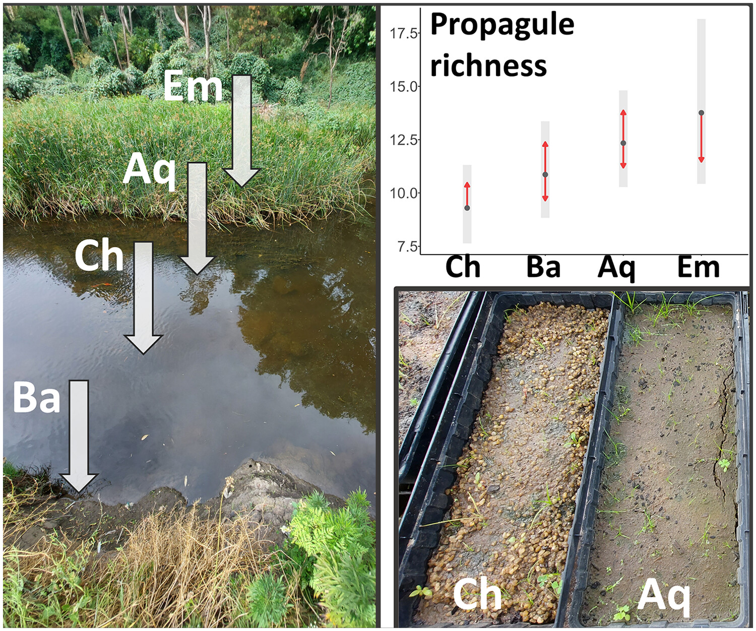
Few studies have investigated both propagule and fine sediment retention by submerged aquatic plants in the context of land use. Through propagule bank trials and sediment analysis, we found that marginal emergent and submerged aquatic vegetation traps more propagules, fine sediment and organic matter than unvegetated stream locations. This trapping function, however, diminishes from rural to urban streams. These results have important implications for the ecosystem engineering role of marginal and aquatic plants across different land uses.
Inbuilt age, residence time, and inherited age from radiocarbon dates of modern fires and late Holocene deposits, Western Transverse Ranges, California
- Pages: 2552-2566
- First Published: 07 May 2024
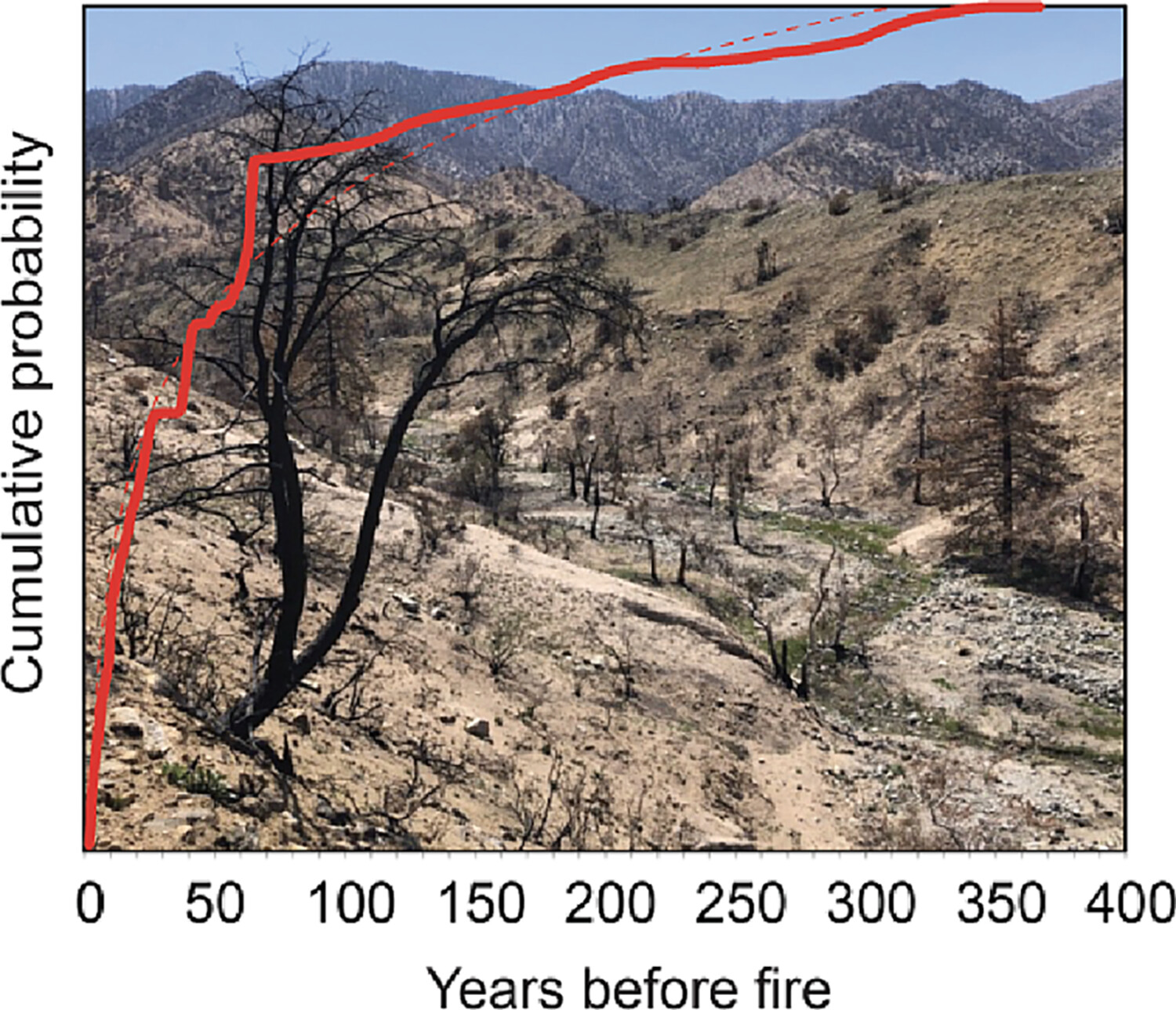
- Radiocarbon dates of recent fires provide robust estimate of inbuilt age of ~25 years for the San Gabriel Mountains.
- In late Holocene deposits, inherited ages of ~90 years are similar to a simulated inherited age when pre-bomb calibration is applied to the inbuilt age, indicating reworked material with long residence times are uncommon.
- Dates from recent fires can be used to improve the accuracy of depositional ages of past fires, paleoclimatic change, and paleoearthquakes in stratigraphic sequences.
CASE STUDY
Quaternary evolution of the Jinshan Gorge and Yellow River: Insight from numerical modelling and terrace correlation
- Pages: 2567-2582
- First Published: 20 April 2024
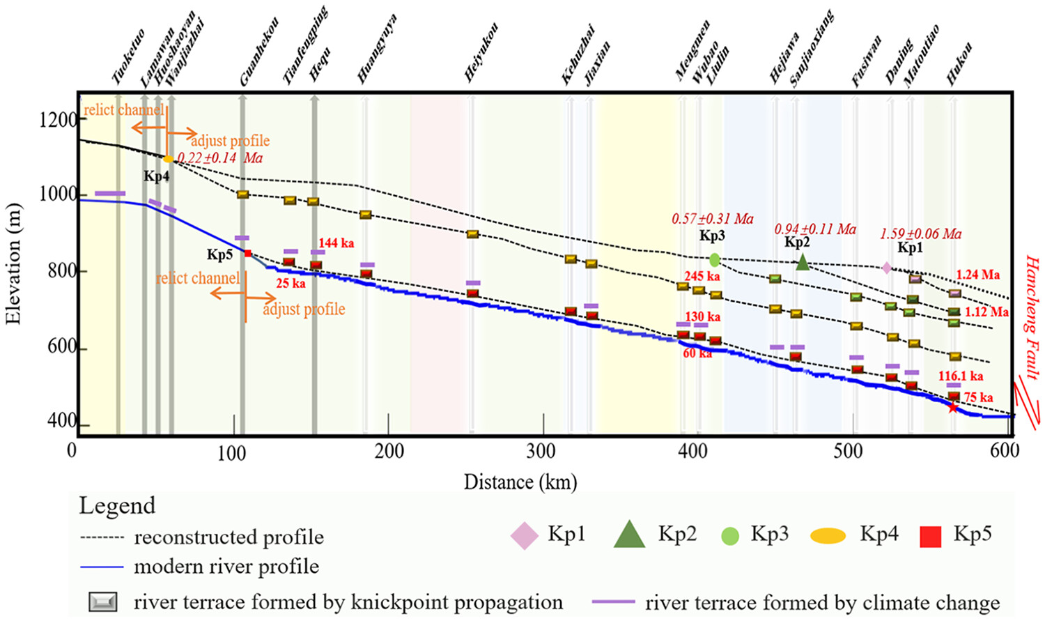
- The migration of knickpoint and a headward wave of fluvial incision responded to fault activities before 130 ka and were dramatically influenced by climate change from 130 ka to the present. The terraces developed in Jinshan Gorge Yellow River were correlated in detail with each tectonic knickpoint.
- The time when the Yellow River cutting through the Jinshan Gorge was constrained by the oldest knickpoint age of 1.59 Ma. The fluvial process of the Yellow River in the Jinshan Gorge was also restored from 8 Ma to the present.
- Topographic characteristics, longitudinal profiles, Ksn distribution, forward and inverse numerical models and reconstructed profiles in the Jinshan Gorge Yellow River are studied to explore the knickpoint and fluvial evolution.
Sign up for email alerts
Tools
More from this journal
- Award Winners
- Special Issues
- State of Science
- Call for Papers - Special Issue: The geomorphic signature of marine and continental Quaternary deposits
- Call for Papers - Special Issue: Earth surface processes and climate change at the Earth’s three poles
- Call for Papers - Special Issue: Novel approaches to quantify landscape changes (Cuchlaine King Symposium 2023)
- Call for Papers - Special Issue: Extreme Events in Geomorphology (Cuchlaine King Symposium 2024)
- Call for Papers - Special Issue: Applications of Artificial Intelligence in Geomorphology
- Call for Papers - Special Issue: Influence of tectonics and climate on landscape evolution: process and modelling
- Call for Papers - Special Issue: Fluvial processes and landforms in the Tibetan plateau in a period of rapid climate change
- Call for Papers - Special Issue: Wood in World Rivers 5
- Call for Papers - Spatial and temporal evolution of landslides induced by global climate change
- Call for Papers - Earth-Surface Processes in the Anthropocene: Human Impact, Climate Change, and Geomorphological Responses
- ESEX Commentaries
- BACKFILES An Online Archive from 1976 to 1995
- Other Resources
Latest Virtual Special Issues:
Is there a geomorphological case for the Anthropocene?
Chaired by Stephen Tooth, with panellists Professor Tony Brown, Simon Price and Professor Andreas Lang. Are we in the Anthropocene and no longer in the Holocene? Has human activity integrated and changed natural processes? Have we created our own geological time period?