

Journal list menu

 Issue
IssueEarth Surface Processes and Landforms: Volume 49, Issue 14
4551-4882November 2024
Export Citations
Download PDFs
ISSUE INFORMATION
RESEARCH ARTICLE
Investigating palaeodune orientations and contemporary wind regimes in Southeast Kazakhstan using a semi-automated mapping framework
- Pages: 4553-4569
- First Published: 29 August 2024
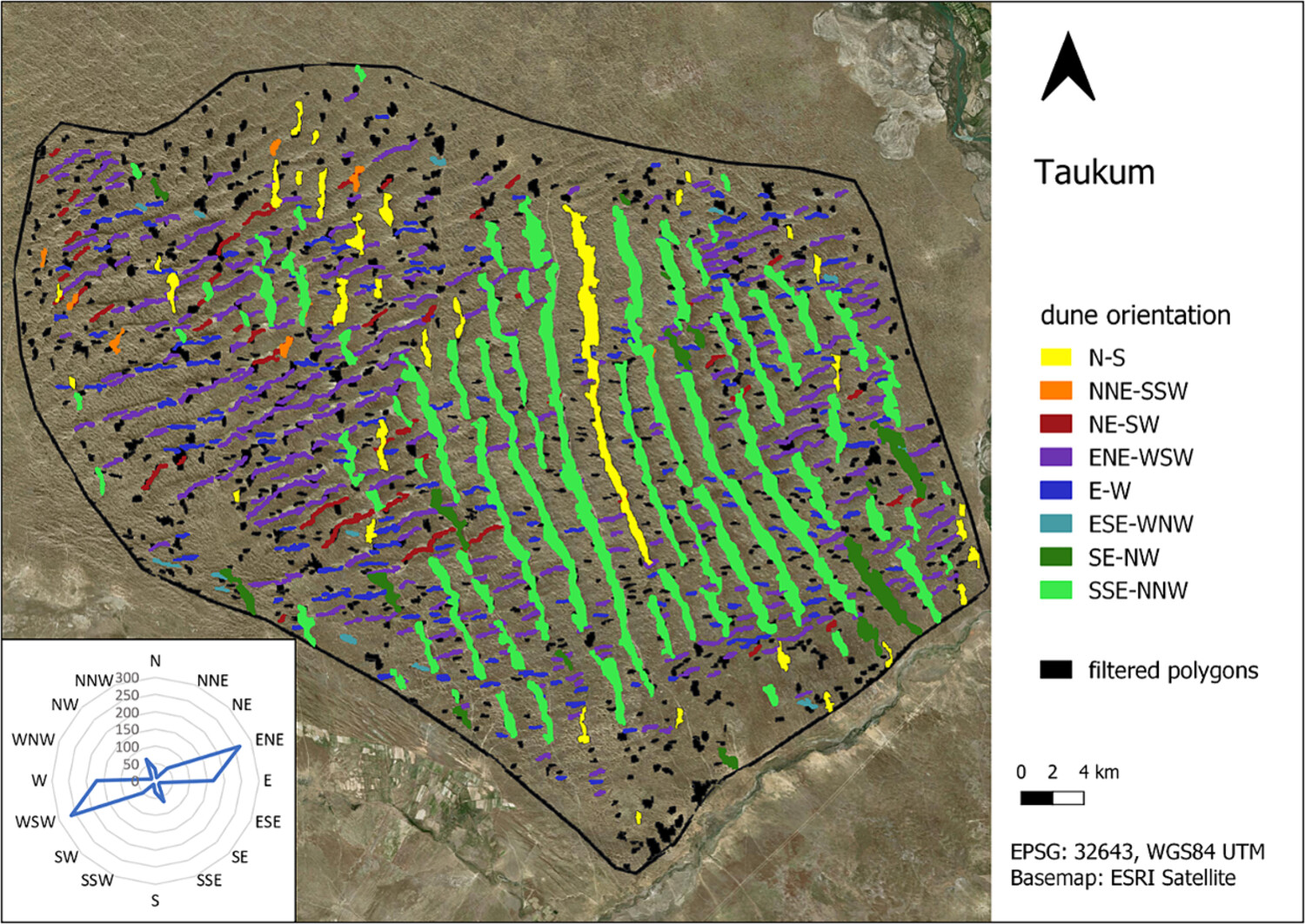
We present a semi-automated framework applying object-based analysis of Sentinel-2 and digital elevation data to map dunes and quantify their orientation. The approach is applied to five dune fields in the Ili-Balkhash region in Kazakhstan. Comparing bedform orientations with the modern wind regime, we find (1) better alignment considering only strong winds and (2) no alignment between bedform orientations and modern wind regime in some dune fields, suggesting a change in local wind dynamics since the last phase of dune activity.
Hydrogeomorphic response of steep streams following severe wildfire in the Western cascades, Oregon
- Pages: 4570-4586
- First Published: 08 October 2024
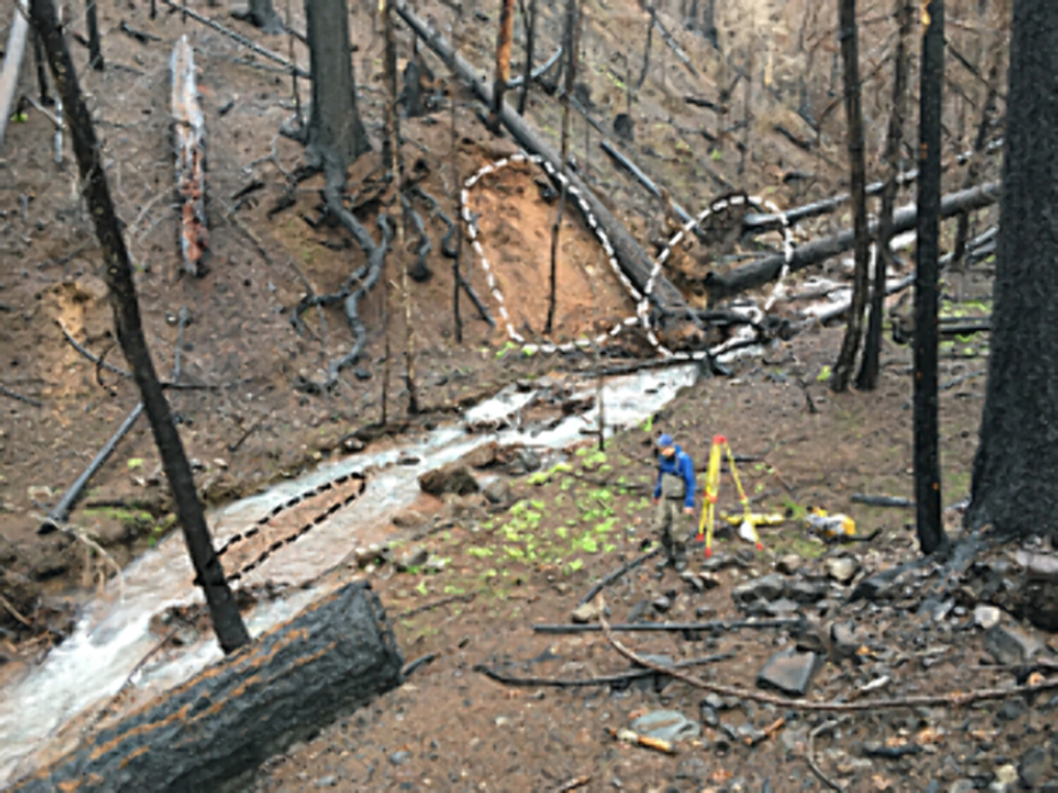
We evaluated the hydrogeomorphic response of steep streams to large-scale, severe 2020 fires in a region with high mean annual precipitation and decades-to-centuries mean fire-return intervals. Post-fire landscape responses reflected climate influences, and specifically below-average precipitation, during the post-fire period. Transient changes in grain size and bed elevation reflected changes in the balance of sediment supply versus transport capacity, but thresholds for debris flows and channel reorganization were not exceeded.
Development of the critical zone environment in the highly dynamic landscape of the Forni Glacier forefield: Winds, tree vegetation, pedogenesis and surface waters after glacier retreat
- Pages: 4587-4609
- First Published: 11 September 2024
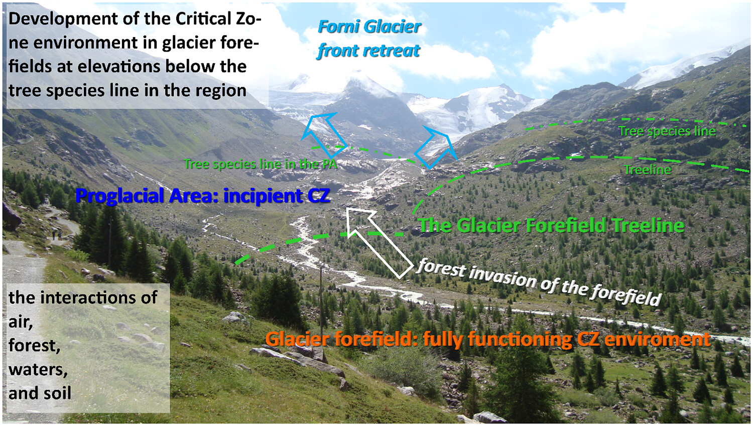
The development of the Critical Zone (CZ) environment in the expanding Forni Glacier forefield after glacier retreat, has been analysed over time since the end of the Little Ice Age by considering different sectors: air (katabatic winds), forest (ecesis times and colonization patterns), surface waters (soil moisture patterns and water isotopic signatures) and soil (pedogenesis). We could distinguish the lower portion, which occurs below the glacier-forefield treeline (GFT), where a fully functioning CZ environment has developed, and the upper portion, which occurs above the GFT, in the proglacial area (PA), where only an incipient CZ exists. By analysing the horizontal processes driving the geomorphic and biotic evolution patterns in this glacier forefield, the work introduces a novel approach for assessing the development of the CZ environment over time.
Mind the information gap: How sampling and clustering impact the predictability of reach-scale channel types in California (USA)
- Pages: 4610-4631
- First Published: 23 September 2024
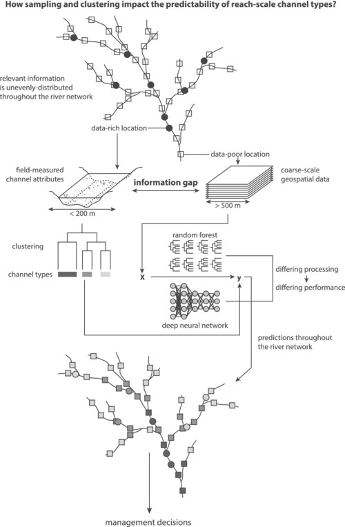
Combining machine learning clustering and prediction is valuable when unevenly distributed information leads to an information gap between data-rich and data-poor locations. Clustering at data-rich locations impacts subsequent predictions at data-poor predictions, and this effect is stronger for deep neural networks than for random forest. There is a trade-off between collecting the minimum number of observations to uniformly capture natural variability and collecting enough data to ensure that a generalisable pattern is learned.
The feasibility of using national-scale datasets for classifying wetlands in Arizona with machine learning
- Pages: 4632-4649
- First Published: 23 September 2024
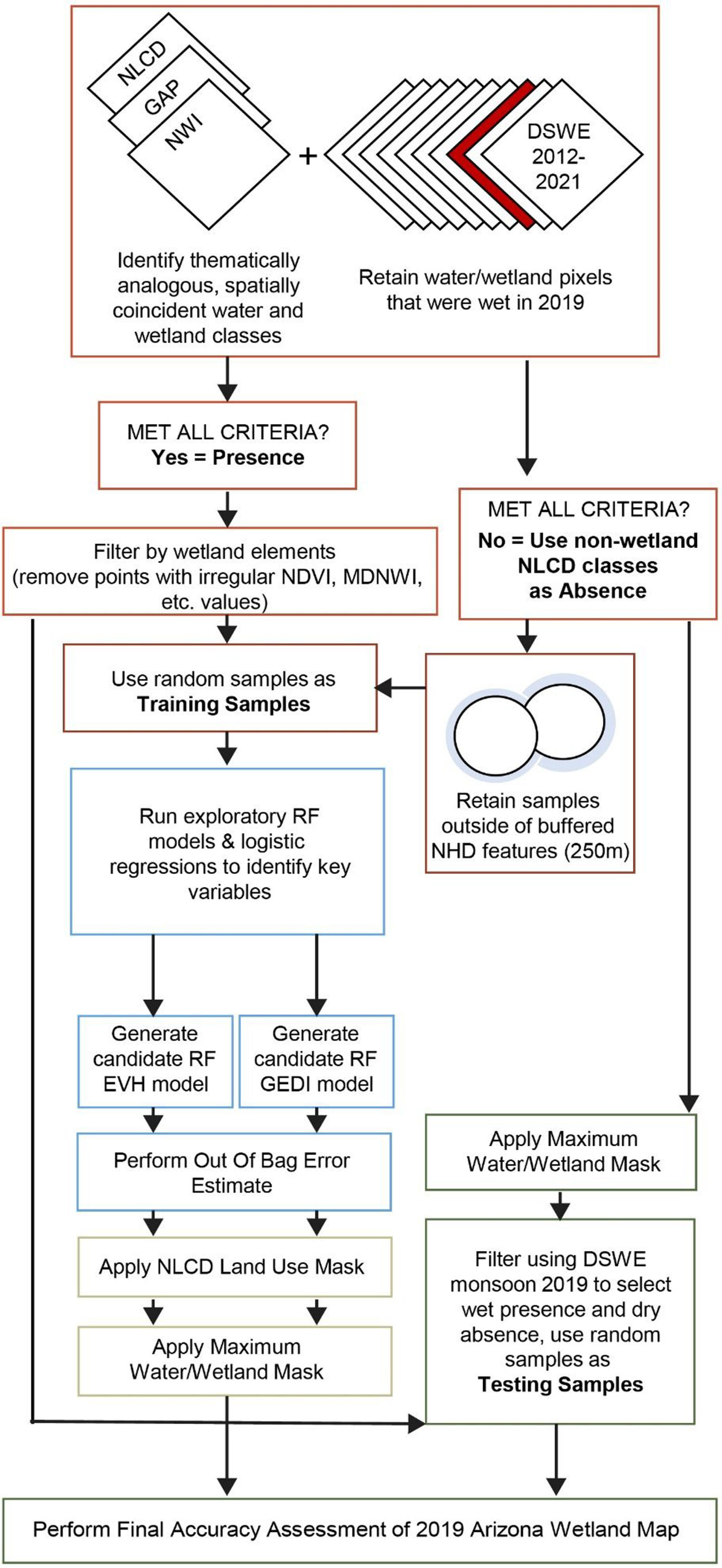
The paper describes how existing wetland data can be used to train a random forest ML model in Google Earth Engine and generate an accurate map of wetlands for the U.S. State of Arizona. Methods can be easily applied to other parts of the U.S.
Determining pore size distribution in rocks using shear-thinning fluids: Utilisation of the method in geomorphology
- Pages: 4650-4662
- First Published: 14 September 2024
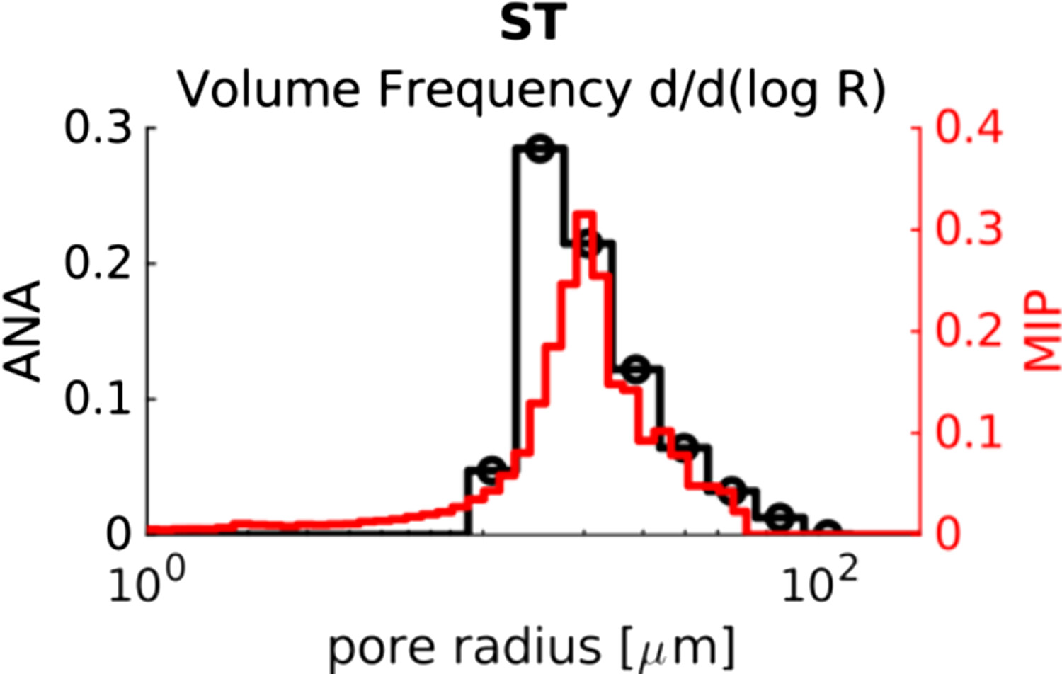
The ANA method has been tested for the first time to determine the pore size distribution of compact materials. The results are compared with mercury intrusion porosimetry and the advantages and disadvantages of the ANA method are discussed, together with its potential application in geomorphology.
Soil erosion estimation in a catchment with implemented soil and water conservation measures
- Pages: 4663-4678
- First Published: 27 September 2024
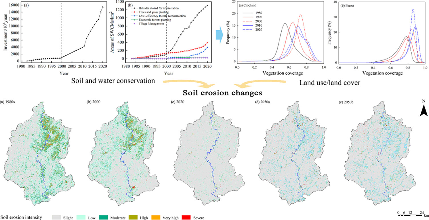
- Soil erosion intensity continued to decrease from 1980s to 2020, and the contribution of LULC impacts ranged from 74%–195%.
- Predictions of land use subtypes indicated that LULC may be stable after 2020.
- The major driving factor of soil erosion changes may shift from LULC to precipitation after 2020.
Geomorphological evolution in transitional environments on the eastern coast of Brazil
- Pages: 4679-4693
- First Published: 13 September 2024
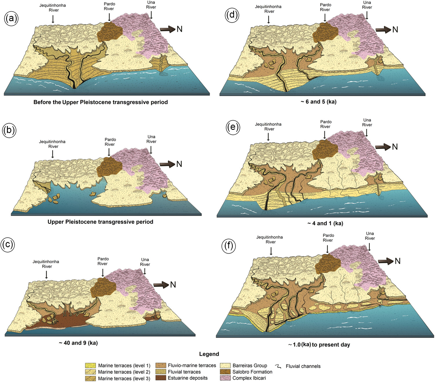
This figure presents the synthesis of the main phases in the geomorphological evolution of the coastal plain landscape between the Jequitinhonha, Una and Pardo rivers (BA, Brazil) from the upper Pleistocene to the Holocene.
Fluvial responses to Holocene climatically induced coastline migration in the Iguape River estuary (Southeast Brazil)
- Pages: 4694-4708
- First Published: 13 September 2024
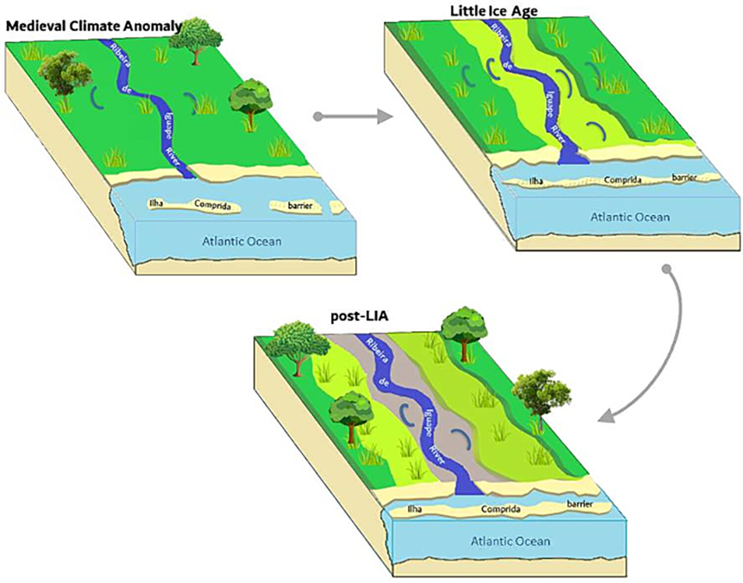
During the Late Holocene, fluctuations in precipitation rates have triggered significant changes along the coastline, prompting adjustments to the base level. This, in turn, has led to the formation of distinct orders of low fluvial terraces along the Ribeira de Iguape River in São Paulo, Brazil.
Applicability of the longitudinal profile–based cirque classification—A test with large cirque datasets in the southeastern Tibetan Plateau
- Pages: 4709-4723
- First Published: 23 September 2024
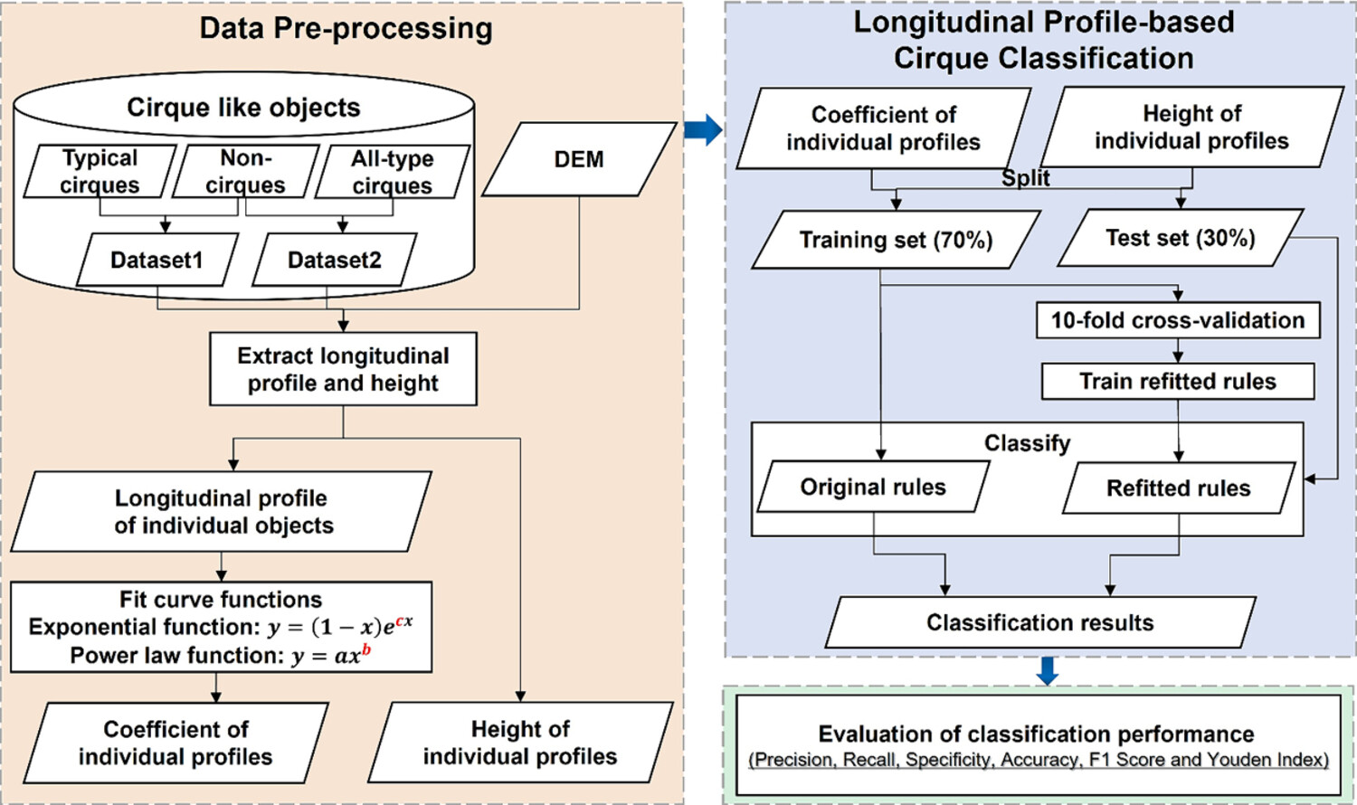
In this study, we verified that the longitudinal profile–based cirque classification method is applicable to classify the relatively large cirque and non-cirque dataset in southeastern Tibetan Plateau, including dataset 1 (256 typical cirques and 101 non-cirques) and dataset 2 (883 all-type cirques and 101 non-cirques).
Exploiting the synergy of SARIMA and XGBoost for spatiotemporal earthquake time series forecasting
- Pages: 4724-4742
- First Published: 01 October 2024
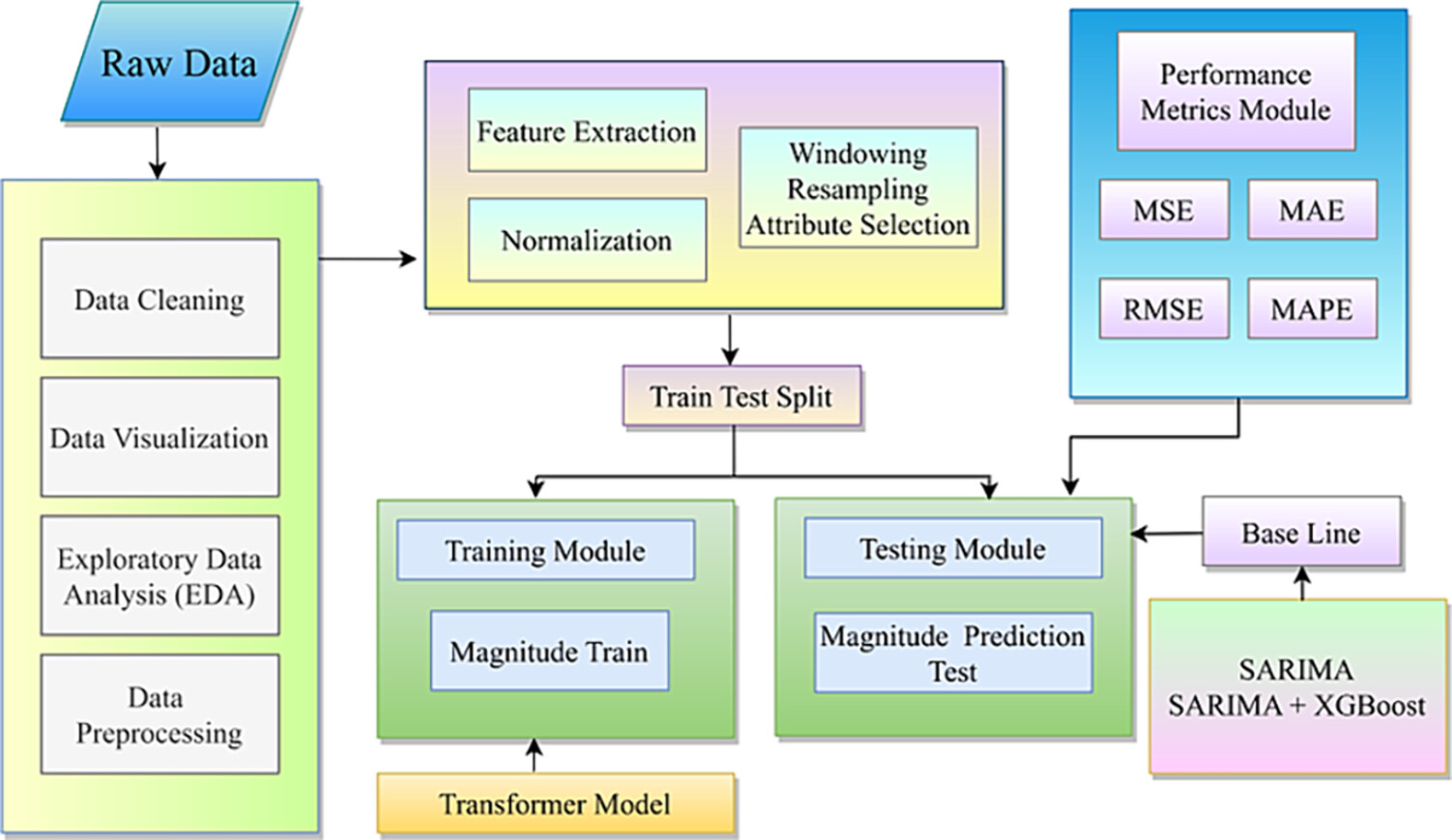
The image depicts a block diagram outlining the steps involved in a machine learning workflow using a hybrid SARIMA–XGBoost model for earthquake time series forecasting. (a) Raw data undergo preprocessing steps, including data cleaning and train-test splitting. (b) The SARIMA model generates initial forecasts, whilst the XGBoost model refines these predictions. (c) Performance is evaluated using various metrics.
Dynamics and internal structure of a rock glacier: Inferring relationships from the combined use of differential synthetic aperture radar interferometry, electrical resistivity tomography and ground-penetrating radar
- Pages: 4743-4758
- First Published: 29 September 2024
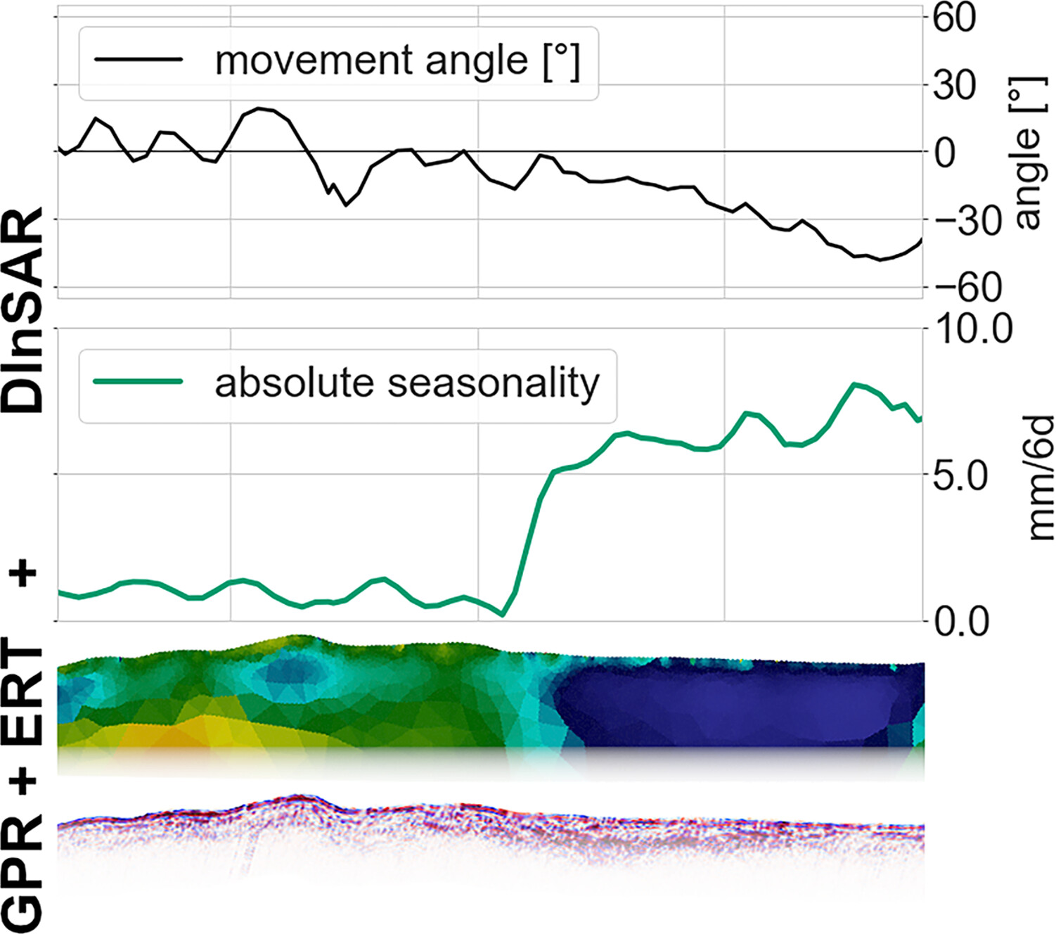
Our study combines geophysical surveys (ground-penetrating radar and electrical resistivity tomography) with surface movement parameters derived from satellite-based differential SAR interferometry. We show that this combination improves the understanding of current geomorphological surface dynamics, as seasonal acceleration and movement angle are sensitive to changes in sub-surface properties.
Debris-flow fan channel avulsions: An important secondary erosional process along the Ichino-sawa torrent, Japan
- Pages: 4759-4775
- First Published: 17 September 2024
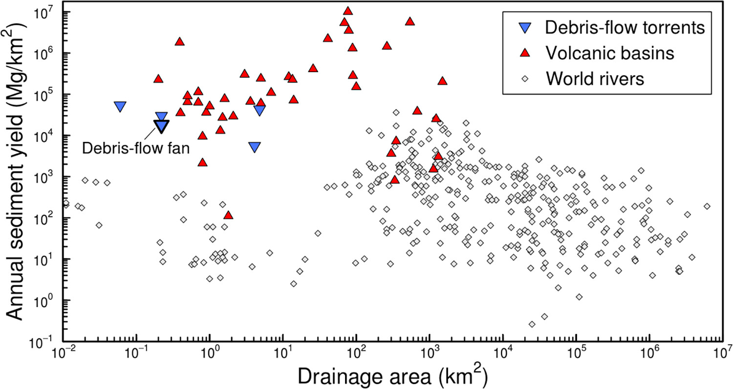
Avulsion in the studied debris-flow fan is triggered by water supply into an existing plugged and steepened channel rather than by sporadic intense rainfall events. The annual sediment yield from avulsion exceeds almost all instances of that in the world rivers and is comparable with that linked to volcanic eruptions and their aftermath. Avulsion is a process of substantial sediment transport independent of volcanic perturbations and extreme climatic events.
Effect of soil hydrological conditions on rainfall erosion on coastal saline soil slopes
- Pages: 4776-4787
- First Published: 12 September 2024
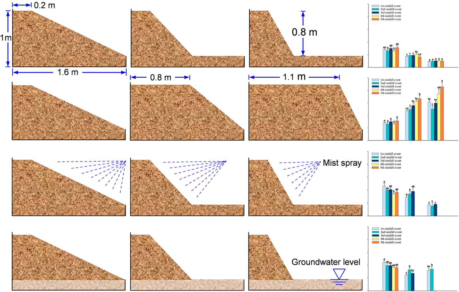
Effects of the slope gradient on erosion on engineered slopes vary with slope length. Slope stability is significantly influenced by the combined effect of slope topography factors and soil hydrological conditions.
Research Article
Multiscale characterization of splays produced by a historic, rain-on-snow flood on a large braided stream (Platte River, Central USA)
- Pages: 4788-4807
- First Published: 26 September 2024
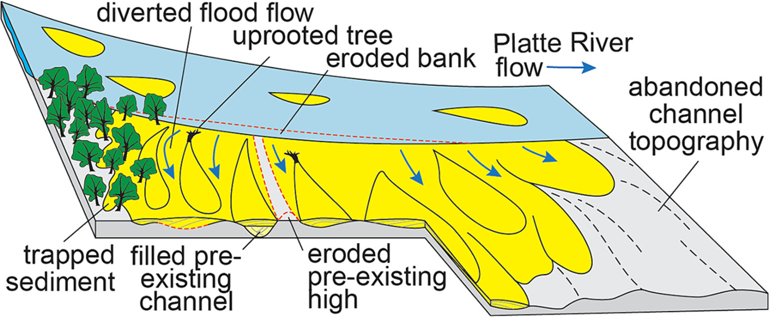
A historical flood generated 32 splays covering 1,438 ha along a 122 km reach of the braided lower Platte River. 94% of the splays were bank-top splays deposited on abandoned braid channels presently cultivated for row crops. Splays pose an increasing hazard as rain-on-snow floods are becoming more common in the central USA.
RESEARCH ARTICLE
Cosmogenic 10Be- and 21Ne-based model exposure ages of desert pavements in the Thar Desert, India
- Pages: 4808-4822
- First Published: 14 October 2024
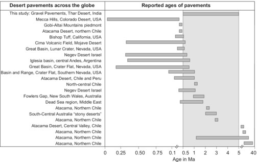
The Thar Desert, India has desert pavements of angular to well-rounded gravels at higher elevations. Sedimentological and geomorphic analyses suggest these pavements are lags of weathered bedrock. The Presence of Palaeolithic artefacts on pavements indicates their antiquity. This study presents surface exposure ages of 1.11 to 5.4 Ma based on cosmic-ray-produced 10Be and 21Ne.
CASE STUDY
Geomorphological processes and landforms in the Alpine Sulzenau Valley (Tyrol, Austria): Glacier retreat, glacial lake evolution and the 2017 glacial lake outburst flood
- Pages: 4823-4841
- First Published: 09 October 2024
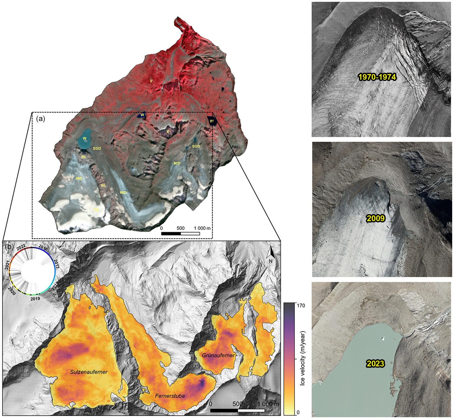
This study investigates Lake Sulzenau in Tyrol, Austria, focusing on the glacial lake outburst flood (GLOF) that occurred in 2017. By employing multi-source remote sensing data and geomorphological analysis, the research reveals that the GLOF was likely triggered by a dam failure resulting from increased meltwater and precipitation, alongside ongoing glacier retreat, highlighting the intricate environmental changes and hazards in Alpine regions under the influence of global warming.
Tsunami propagation and flooding maps: An application for the Island of Lampedusa, Sicily Channel, Italy
- Pages: 4842-4861
- First Published: 18 September 2024
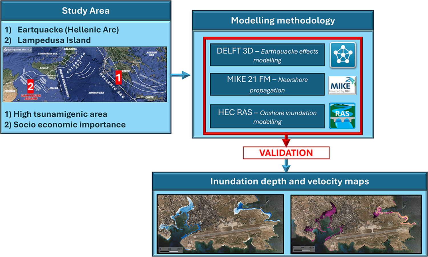
The graphical abstract summarizes the tsunami inundation risk assessment for Lampedusa Island. It highlights the study area (Hellenic Arc and Lampedusa), the high tsunamigenic risk of the Hellenic Arc and socio-economic importance of Lampedusa. The modelling methodology includes the adoption of DELFT-3D, MIKE 21 FM and HEC-RAS software. It shows the calculation chain and validation process, with inundation depth and velocity maps that are the outputs of the workflow.
PS-InSAR post-processing for assessing the spatio-temporal differential kinematics of complex landslide systems: A case study of DeBeque Canyon Landslide (Colorado, USA)
- Pages: 4862-4880
- First Published: 21 October 2024
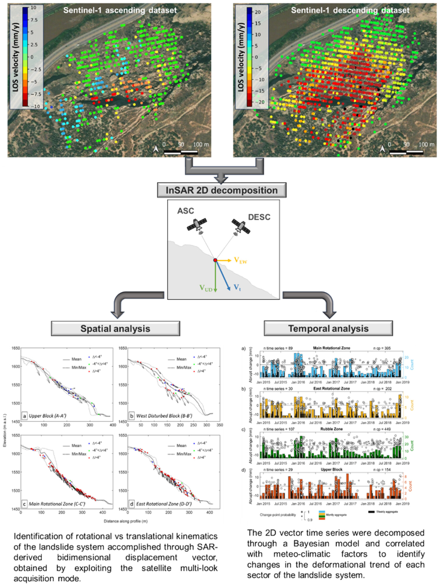
SAR-derived 2D displacement vectors revealed rotational and translational kinematics within the landslide system. Bayesian decomposition of these vector time series, correlated with meteo-climatic factors, identified distinct deformational trends across different landslide sectors.
CORRIGENDUM
Correction to A regime shift in sediment export from a coastal watershed during a record wet winter, California: Implications for landscape response to hydroclimatic extremes
- Pages: 4881-4882
- First Published: 21 October 2024
Sign up for email alerts
Tools
More from this journal
- Award Winners
- Special Issues
- State of Science
- Call for Papers - Special Issue: The geomorphic signature of marine and continental Quaternary deposits
- Call for Papers - Special Issue: Earth surface processes and climate change at the Earth’s three poles
- Call for Papers - Special Issue: Novel approaches to quantify landscape changes (Cuchlaine King Symposium 2023)
- Call for Papers - Special Issue: Extreme Events in Geomorphology (Cuchlaine King Symposium 2024)
- Call for Papers - Special Issue: Applications of Artificial Intelligence in Geomorphology
- Call for Papers - Special Issue: Influence of tectonics and climate on landscape evolution: process and modelling
- Call for Papers - Special Issue: Fluvial processes and landforms in the Tibetan plateau in a period of rapid climate change
- Call for Papers - Special Issue: Wood in World Rivers 5
- Call for Papers - Spatial and temporal evolution of landslides induced by global climate change
- Call for Papers - Earth-Surface Processes in the Anthropocene: Human Impact, Climate Change, and Geomorphological Responses
- ESEX Commentaries
- BACKFILES An Online Archive from 1976 to 1995
- Other Resources
Latest Virtual Special Issues:
Is there a geomorphological case for the Anthropocene?
Chaired by Stephen Tooth, with panellists Professor Tony Brown, Simon Price and Professor Andreas Lang. Are we in the Anthropocene and no longer in the Holocene? Has human activity integrated and changed natural processes? Have we created our own geological time period?