

Journal list menu

 Issue
IssueEarth Surface Processes and Landforms: Volume 43, Issue 15
i, 2981-3196December 2018
Export Citations
Download PDFs
Cover image
Cover Image
- Page: i
- First Published: 02 December 2018
The cover image, by Joel S. Sholtes et al., is based on the Research Article Longitudinal variability of geomorphic response to floods, https://doi.org/10.1002/esp.4472.
Issue Information
Research Articles
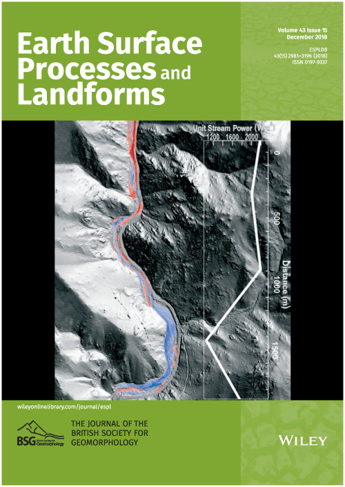
Quantification of cliff retreat in coastal Quaternary sediments using anatomical changes in exposed tree roots
- Pages: 2983-2997
- First Published: 28 June 2018
Determination of exposure years was based on the sharp decrease of cell lumen area of earlywood tracheids. This contribution demonstrates that dendrogeomorphic analyses of roots clearly have a significant potential and that they are a powerful tool for the quantification of multidecadal rates of cliff retreat in areas where measurements of past erosion are lacking.
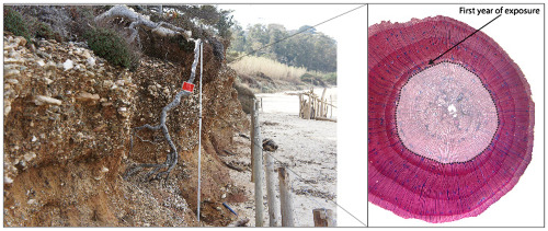
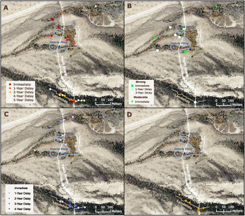
Patterns of debris flow initiation and periglacial sediment sourcing in the Colorado Front Range
- Pages: 2998-3008
- First Published: 29 June 2018
We characterized 11 debris flows that occurred at high elevations during the September 2013 storm in Rocky Mountain National Park and found that geomorphic controls on initiation include topographic convergence and slope aspect. 10Be exposure dating and stratigraphic data provide evidence that up to seven debris flows have occurred at one site in the last 75 ka, two within the last 8 ka. Individual sample ages suggest that greatest sediment production occurred during Quaternary glacial stages due to periglacial processes.
River response to large-dam removal in a Mediterranean hydroclimatic setting: Carmel River, California, USA
- Pages: 3009-3021
- First Published: 29 June 2018
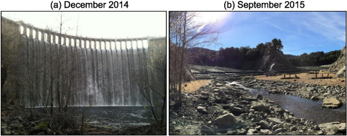
We present the first study of river response to removal of a large dam in a Mediterranean hydroclimatic setting. We demonstrate that when a substantial proportion of sediment is sequestered in place, high flows can become relatively more important as drivers of geomorphic change than is the dam removal alone. This result contrasts many previous dam removals from other bioregions where studies found little connection between post-dam-removal flow magnitude and the coupled processes of reservoir-sediment erosion and downstream deposition.
A fundamental equation for describing the rate of bedrock erosion by sediment-laden fluid flows in fluvial, coastal, and aeolian environments
- Pages: 3022-3041
- First Published: 09 August 2018
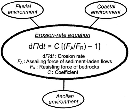
A unified equation is presented which enables us to describe the rate of bedrock erosion caused by fluid flows containing sediment particles in fluvial, coastal, and aeolian environments. An investigation by use of existing data confirms the validity and the applicability of the equation.
Evolution of a large Baltic beach ridge plain (Neudarss, NE Germany): A continuous record of sea-level and wind-field variation since the Homeric Minimum
- Pages: 3042-3056
- First Published: 05 September 2018
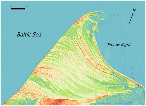
The development of one of the largest beach ridge plains in Europe (Neudarss, Southern Baltic), originating about 600 BCE, is reconstructed by means of extensive OSL dating, linking the dynamics of the plain's progradation and changes in the ridge morphology to climate and sea-level changes on multi-centennial to multi-decadal time scales.
Transferability of a calibrated numerical model of rock avalanche run-out: Application to 20 rock avalanches on the Nuussuaq Peninsula, West Greenland
- Pages: 3057-3073
- First Published: 24 July 2018
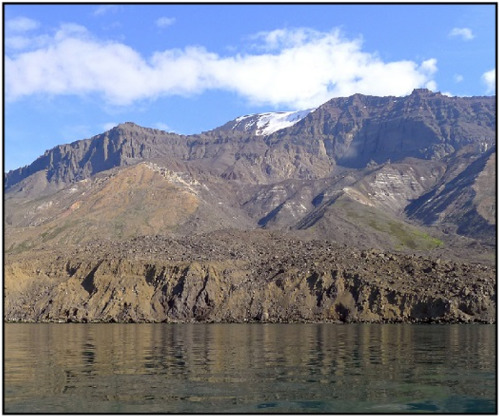
- 1) A set of 20 adjacent rock avalanche deposits is used to test the tranferabiity of a calibrated numerical model of rock avalanche run-out.
- 2) A single pair of rheological parameters accurately simulates the general characteristics of 20 different events.
- 3) Results suggests that first-order run-out prediction is possible and therefore transferable.
Hydrology and hillslope processes explain spatial variation in tree-ring responses to the 1983 earthquake at Borah Peak, Idaho, USA
- Pages: 3074-3085
- First Published: 12 July 2018
Tree-ring responses to the earthquake were more than twice as common in sites with hydrologic changes or co-seismic mass movement. Growth releases were primarily associated with increases in flow from streams and springs rather than the death of neighboring trees. Traumatic resin ducts in Douglas-fir and Engelmann spruce were associated with co-seismic rockfalls and landslides. Applications of dendrogeomorphology to paleosesimology should include sites with potential hydrologic changes or mass movement, and trees without external evidence of earthquake impacts.
Effects of deep-seated versus shallow hillslope processes on cosmogenic 10Be concentrations in fluvial sand and gravel
- Pages: 3086-3098
- First Published: 16 July 2018
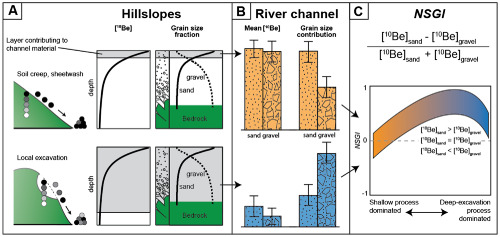
The comparison of 10Be derived denudation rates to a hillslope-process inventory reveals a shift in hillslope processes as denudation rates increase. To test if a signal of hillslope processes is preserved in the 10Be concentration of fluvial sediment, we define the normalized sand-gravel index (NSGI) as the 10Be-concentration difference between sand and gravel. We find a positive relationship between NSGI and slope, such that NSGI values broadly reflect the shift in hillslope processes.
Longitudinal variability of geomorphic response to floods
- Pages: 3099-3113
- First Published: 17 July 2018
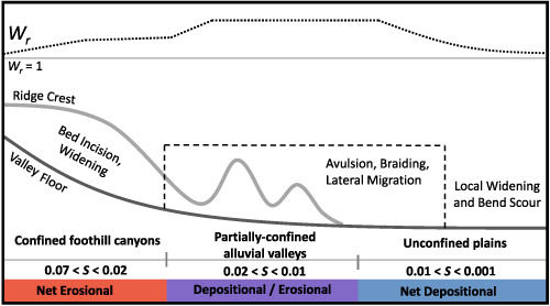
Geomorphic response to floods is influenced by gradients of flood stream power and valley confinement at reach and landscape-scales in the transition from mountains to plains.
Late Quaternary uplift across northwest Luzon Island, Philippines constrained from emergent coral reef terraces
- Pages: 3114-3132
- First Published: 27 July 2018
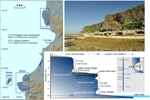
Emergent coral reef terraces and tidal notches are useful geomorphic markers in constraining RSL changes and tectonic processes along offshore and onland faults. This study reports new geomorphic and radiometric data in northwest Luzon as evidence of RSL changes and possible prehistoric earthquakes along the Manila subduction zone and its forearc region during the mid-Holocene. This study offers new insights to the preservation of long-term deformation along the coast that is bordered by a subduction zone and upper-plate faults.
Regime shifts in the multi-annual evolution of a sandy beach profile
- Pages: 3133-3141
- First Published: 26 July 2018
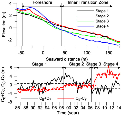
Four morphological stages separated by regime shifts in beach profile evolution were identified on the Hasaki coast, Japan during the 28-year period from 1986 to 2014. From stage 2 to stage 4, the inner transition zone was heavily eroded, and the foreshore was largely accreted. Stage 4 persisted to the end of the study period, approximately 7 years.
Hourly to daily-scale microtopographic fluctuations of supratidal sandstone
- Pages: 3142-3151
- First Published: 26 July 2018
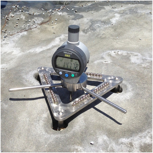
Measured with a traversing micro-erosion meter (TMEM), the microtopography of supratidal sandstone was observed to be highly dynamic in response to microclimatic variations at 2-hourly scale, primarily driven by the fluctuating humidity. The rock surface underwent no net microtopographic loss of material at daily scale and could be divided into three periods of different movement trends: falling (06:00–12:00), rising (12:00–20:00) and stable (20:00–06:00), while an overall contraction occurred at multiday scale.
Landscape ‘stress’ and reorganization from χ-maps: Insights from experimental drainage networks in oblique collision setting
- Pages: 3152-3163
- First Published: 27 July 2018
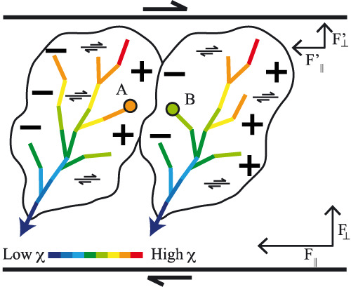
The analysis of χ distribution along experimental drainage networks evolving in oblique collision setting reveals first, that the χ pattern is consistent with the imposed deformation and can thus be used to infer horizontal tectonic deformation, and second, that the orientation of the observed gradients in χ correctly anticipates the direction of divide migrations for 2/3 of the divides affected by such gradient.
Landslide shape, ellipticity and length-to-width ratios
- Pages: 3164-3189
- First Published: 03 August 2018
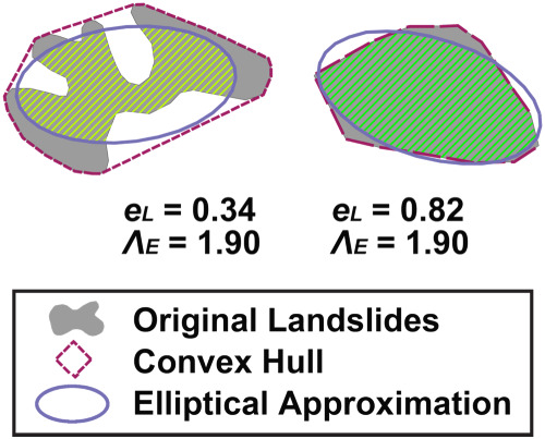
We present a methodology to systematically quantify the shape of landslides by their ellipticity (eL) and length-to-width ratio (ΛE). An ellipse is a reasonable model for >80% of landslides. Landslides that deviate from an ellipse are related to landscape processes. ΛE ranges 1.2–15.1 and is non-normally distributed.
ESEX Commentary
Breaking from the average: Why large grains matter in gravel-bed streams
- Pages: 3190-3196
- First Published: 02 July 2018
Sign up for email alerts
Tools
More from this journal
- Award Winners
- Special Issues
- State of Science
- Call for Papers - Special Issue: The geomorphic signature of marine and continental Quaternary deposits
- Call for Papers - Special Issue: Earth surface processes and climate change at the Earth’s three poles
- Call for Papers - Special Issue: Novel approaches to quantify landscape changes (Cuchlaine King Symposium 2023)
- Call for Papers - Special Issue: Extreme Events in Geomorphology (Cuchlaine King Symposium 2024)
- Call for Papers - Special Issue: Applications of Artificial Intelligence in Geomorphology
- Call for Papers - Special Issue: Influence of tectonics and climate on landscape evolution: process and modelling
- Call for Papers - Special Issue: Fluvial processes and landforms in the Tibetan plateau in a period of rapid climate change
- Call for Papers - Special Issue: Wood in World Rivers 5
- Call for Papers - Spatial and temporal evolution of landslides induced by global climate change
- Call for Papers - Earth-Surface Processes in the Anthropocene: Human Impact, Climate Change, and Geomorphological Responses
- ESEX Commentaries
- BACKFILES An Online Archive from 1976 to 1995
- Other Resources
Latest Virtual Special Issues:
Is there a geomorphological case for the Anthropocene?
Chaired by Stephen Tooth, with panellists Professor Tony Brown, Simon Price and Professor Andreas Lang. Are we in the Anthropocene and no longer in the Holocene? Has human activity integrated and changed natural processes? Have we created our own geological time period?