Evolution of the main channel of the Yangtze River
Abstract
The construction and operation of the Three Gorges Reservoir and the cascade reservoirs upstream have significantly altered the processes of flow and sediment in the main and tributary channels of the Yangtze River. This has led to substantial adjustments in the riverbed through erosion and deposition, thereby impacting flood protection, water resource utilization, navigation, and the aquatic environment in the Yangtze River basin. In this study, prototype measurements were used to analyze the variations in runoff and sediment load in the main channel of the Yangtze River, as well as the changes and evolution of the riverbed. Mathematical modeling was done to predict the trends in reservoir sedimentation and riverbed adjustments. The results indicate that, apart from the significantly increased runoff and sediment load in the river source region (Zhimenda station) over the past two decades, there is no clear unidirectional trend of increasing or decreasing in the main and tributary annual runoff of the Yangtze River. However, the release of reservoir outflows undergoes significant changes throughout the year due to reservoir regulation. Suspended sediment load in the upper Yangtze River has been decreasing since the 1990s, especially after the operation of the Three Gorges Reservoir and the four cascade reservoirs in the lower reach of the Jinsha River. The factors influencing flow and sediment variations include mainly climate change and human activities such as reservoir operation and soil and water conservation. The significant changes in flow and sediment conditions have disrupted the original relative equilibrium state of the main channel of the Yangtze River, leading to riverbed adjustments. The river sections in the upper reach, located within reservoir areas, have shifted from erosional state under natural conditions to accumulative state, while the middle and lower reaches have transitioned from a relatively equilibrium state to a process dominated by erosion and reconstruction. Overall, the river regime in the reservoir area and downstream of the Three Gorges Dam remains relatively stable, but there have been adjustments in some local river sections, for example, in the curved sections, particularly in the sharply curved sections downstream of the Three Gorges Dam, where gradual or abrupt chute cutoff has occurred. In the foreseeable future, the river channel downstream of the Three Gorges Dam will remain in an unsaturated state regarding sediment transport. The process of river channel erosion will persist for a long time and have far-reaching consequences. Some long straight sections, multiple bifurcation sections, and sections with large curvature are expected to undergo certain adjustments in the river regime, necessitating continuous observation, long-term monitoring, and timely river management and channel governance.
1 INTRODUCTION
1.1 Overview of the river basin
The Yangtze River originates from the southwest of the main peak of the Tanggula Mountains in the Qinghai–Tibet Plateau. It has a basin area of 1.8 million km2, accounting for 18.8% of China's land area. With a total length of over 6300 km and a total drop of about 5400 m, the Yangtze River traverses the southwestern, central, and eastern regions of China, flowing through 11 provinces (autonomous regions, municipalities) including Qinghai, Tibet, Sichuan, Yunnan, Chongqing, Hubei, Hunan, Jiangxi, Anhui, Jiangsu, and Shanghai (see Figure 1). Its tributaries extend to another eight provinces (autonomous regions) including Guizhou, Gansu, Shaanxi, Henan, Guangxi, Guangdong, Zhejiang, and Fujian. The Yangtze River is the largest river in China and the third-largest river in the world.
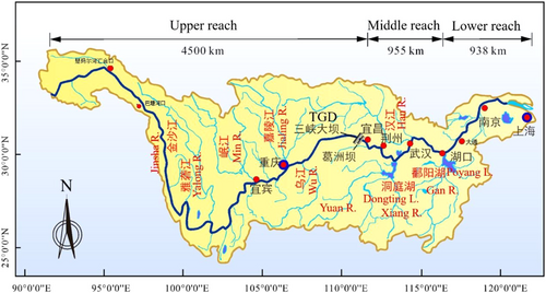
The Yangtze River basin has numerous tributaries and lakes. There are over 9400 tributaries with a basin area of over 50 km2, of which 469 have a basin area of over 1000 km2 and 49 have a basin area of over 10,000 km2. The eight major tributaries, including the Yalong River, Min River, Jialing River, Wu River, Xiang River, Yuan River, Han River, and Gan River, all have a basin area of over 80,000 km2. The Jialing River, with a basin area of 160,000 km2, is the largest. There are 18 tributaries with a length exceeding 500 km, with the Han River being the longest at 1577 km. The existing total area of lakes is approximately 14,200 km2, accounting for about one-fifth of the total lake area in the country. Among them, there are 127 lakes with an area larger than 10 km2 and 34 lakes with an area larger than 100 km2. Poyang Lake and Dongting Lake are the two largest freshwater lakes in the Yangtze River basin.
The average annual precipitation in the Yangtze River basin is about 1100 mm, and the total water resources are 995.8 billion m3, accounting for 35% of the national total. The technically exploitable hydropower capacity in the basin is 281,000 MW, with an annual electricity generation of 1.3 trillion kW h, accounting for 47% and 48% of the national total, respectively. The Yangtze River waterway system has over 3600 navigable rivers, with a total navigable distance of 71,000 km, accounting for 56% of the national inland waterway mileage. The basin is rich in mineral resources, forests, grasslands, wetlands, and fish resources. The Yangtze River basin is a strategic water source for water resource allocation in China, an important clean energy base, a “golden waterway” connecting the eastern, central, and western regions, a significant grain production base, a natural treasury of aquatic organisms, and an important ecological security barrier zone.
1.2 Overview of the main channel of the Yangtze River
The main channel of the Yangtze River is divided into the upper, middle, and lower reaches, primarily based on its spatially varying landscape and climate patterns. The upper reach of the Yangtze River is from the headwater to Yichang, with a length of 4504 km (see Figure 2). Among it, the section from Nangjibalong, where the Dangqu River and Tuotuo River converge, to the Yushu–Batang River mouth (Zhi menda) is called the Tongtian River, with a total length of 828 km. From Zhimenda to Yibin, it is called the Jinsha River, with a total length of 2290 km. From Yibin to Yichang, it is called the Chuan River, with a total length of 1040 km. The upper reach of the Yangtze River are characterized by mountainous river, while the mainstream mostly consists of canyon sections with steep slopes, swift currents, and high flow velocities.
The middle reach of the Yangtze River extends approximately 955 km from Yichang to Hukou, and downstream Hukou is the lower reach, with a length of approximately 938 km (see Figure 3). The section from Zhicheng to Chenglingji is called the Jingjiang River. The Jingjiang River flows through the Jianghan Plain and the Dongting Lake Plain. Along the southern bank, there are outlets such as Songzikou, Taipingkou, Ouchikou, and Tiaoxiankou (controlled by sluice built in 1959), which divert water and sediment into the Dongting Lake. The Dongting Lake gathers further water and sediment from its four main tributary rivers of Xiang, Zi, Yuan, and Li, and then discharges the water and sediment back into the Yangtze River at Chenglingji, forming a complex relationship between rivers and lakes. The Poyang Lake receives water from the Gan River, Fu River, Xin River, Rao River, and Xiu River, and it discharges into the Yangtze River from the north of Hukou, creating an interdependent, inflow and backflow relationship between the Poyang Lake and the Yangtze River.
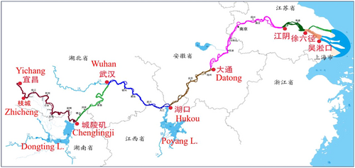
The mainstream of the middle and lower reaches of the Yangtze River has a gentle water surface slope, and the river morphology varies in different sections, including straight, meandering, anabranched, and sinuous types. The boundary conditions of the riverbed also differ.
The section from Yichang to Zhicheng is approximately 61 km long and serves as a transitional zone where mountainous rivers enter the plains. It features a straight to slightly curved river channel with the tributary Qing River joining on the right bank. The area is controlled by low mountains, hills, and terraces, exhibiting strong resistance to erosion. The riverbed is composed of pebbles and sand, with some exposed bedrock. The upper Jingjiang River, from Zhicheng to Ouchikou, is approximately 172 km long and characterized by a meandering and anabranched river channel. The riverbed primarily consists of medium to fine sand, with an average median grain size of about 0.2 mm. The section from Zhicheng to Jiangkou contains gravel and pebbles in the riverbed. The riverbanks are composed of gravel, sand, and cohesive soil, usually consisting of pebbles in the lower part, fine sand in the middle, and cohesive soil layer in the upper part. The northern bank of this section features the Jingjiang dike. The floodplain outside the dike is narrow or absent, with thalweg close to the bank, posing a high flood risk. The lower Jingjiang River, from Ouchikou to Chenglingji, is approximately 175 km long and represents a typical sinuous river channel. The riverbanks are mainly binary structures composed of modern river sediments, with medium and fine sand in the lower part and clay layer in the upper part. The riverbanks have weaker resistance to erosion compared to the upper Jingjiang River. The riverbed is composed of medium to fine sand, with the gravel layer buried deep below the bed surface, and the average median grain size of the bed material is about 0.165 mm. Downstream of Chenglingji, the river channel becomes anabranched, with the inflow of tributaries such as the Poyang Lake, Chao Lake, Tai Lake, and Han River. The geological conditions on two sides of the river channel show obvious heterogeneity. The left bank consists mostly of expansive alluvial plains, while the right bank is characterized by hills and terraces. The riverbanks can be classified into four types: soil, sandy soil, sandy, and bedrock, with sandy banks being the most common. There are 88 nodes composed of exposed bedrock from hills and terraces controlling the river regime. This creates an anabranched river section with alternating narrow and wide channels. The riverbed is primarily composed of fine sand and very fine sand, with an average median grain size of about 0.16 mm. Based on the different planform morphologies, this section of the river can be divided into three types of channels: straight, meandering, and goose-head-shaped channels. The lower reach of the river is influenced by tides after the Datong section.
1.3 Overview of the human activities
To govern, develop, and protect the Yangtze River, a series of water projects have been implemented in China since the establishment of the People's Republic of China over 70 years ago. These projects include soil and water conservation, water conservancy and hydropower engineering, water diversion projects, river channel management projects, navigation channel improvement projects, bank and beach utilization projects, river sand mining, and others. Among them, soil and water conservation projects, water conservancy and hydropower engineering, and water diversion projects aim to alter the flow and sediment conditions in the Yangtze River, while river channel management, navigation channel improvement, bank and beach utilization projects, and river sand mining aim to change the boundary conditions of the river channel, thus impacting the river channel evolution.
- 1.
Over the past 70 years, the Yangtze River basin has achieved a cumulative soil erosion control area of 450,000 km2. The total area of soil erosion in the entire basin has decreased from 622,000 to 346,700 km2, a reduction of 44%. The sediment reduction caused by soil erosion control has a certain long-term effect and can reach a relative equilibrium within a certain period of time.
- 2.
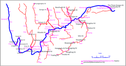
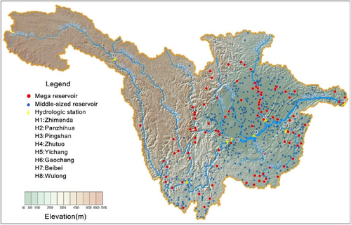
There are approximately 52,000 reservoirs in the Yangtze River basin (see Figure 4), including 303 large-sized reservoirs (each with a total capacity of over 100 million m3) with a total capacity of 332.7 billion m3 and a flood control capacity of 78.8 billion m3. The reservoirs' function of storing water and trapping sediment has led to changes in downstream water discharge processes and sediment reduction. In the initial operation stage, sediment trapping benefits are significant, but once the reservoirs reach equilibrium sedimentation, they no longer provide sediment trapping benefits, and the sediment load downstream would return to a more natural condition.
- 3.
The implemented water diversion projects in the Yangtze River basin mainly include the South-to-North Water Diversion Project (Eastern and Central Routes), the water diversion project from the Yangtze River to the Han River. There are also ongoing projects such as the Yangtze River Diversion to Supplement the Han River Project, the Yangtze River Diversion to Huai River Project, the Yangtze River Diversion to Wei River Project, and the Central Yunnan Water Diversion Project. The implementation of water diversion projects has to some extent altered the distribution of runoff in the Yangtze River.
- 4.
Over the past 70 years, a series of river channel management projects have been implemented in the middle and lower reaches of the Yangtze River, including large-scale bank protection projects, systematic curve cut-off projects in the lower Jingjiang River, branch channel blockage projects in bifurcation sections, river regime control, and comprehensive regulation projects in key river sections. The total length of completed bank protection projects in the middle and lower reaches of the Yangtze River is approximately 1800 km. The implementation of river channel management projects has stabilized the river's planform and played an important role in controlling and improving the river regime.
- 5.
Since the 1990s, more than 50 navigation channel improvement projects have been implemented in the Yangtze River downstream of the Shuifu section. By the end of 2011, all of these channels had met the national high-grade navigation standards. Currently, the navigable depth downstream of Wuhan reaches over 6 m, and downstream of Nanjing reaches 12.5 m.
- 6.
Over the past few decades, a series of bank and beach utilization projects have been implemented in the middle and lower reaches of the Yangtze River. As of the end of 2020, there are a total of 81 cross-river passages (including 13 under construction), including 14 tunnels and 67 bridges; various other water-related infrastructure such as hydrological facilities, water intake and drainage systems, sluice gates, river-crossing pipelines, and river-crossing cables along the riverbanks. The utilization rate of the riverbanks is approximately 23.1% in the middle reach and 28.0% in the lower reach, with Shanghai having the highest rate at 49.2%. The accumulation of numerous water-related projects along the riverbanks has also had a cumulative and significant impact on the long-term evolution of the river channel.
1.4 Research status
The runoff in the upper reach of the Yangtze River is primarily contributed by rivers such as the Jinsha River, Min River, Tuo River, Jialing River, and Wu River. The sediment load mainly comes from the Jinsha River and Jialing River. Since the 1990s, the construction and operation of the world's largest reservoir system in the upper reach of the Yangtze River, with the Three Gorges Reservoir (TGR) as its core, has significantly altered the spatial and temporal distribution patterns of sediment load in the upper reach (Liu et al., 2020; Tan et al., 2019).
Regarding the study of water and sediment characteristics, Zhu (2000) explored the variations of sediment load and sediment concentration, and sediment reduction pathways in the upper Yangtze River. Xiang and Zhou (1993) investigated the sources, transport, and deposition characteristics of sediment in the Yangtze River. Li et al. (2001) studied the spatial and temporal distribution characteristics of flow and sediment transport in the Yangtze River. Chen, Li, et al. (2001) and Chen, Zong, et al. (2001) investigated the variations in flow and sediment in the Yangtze River and analyzed the changes in the inflow of the Yangtze River into the sea during the dry season. Yang et al. (2002) and Yang et al. (2003) conducted preliminary analyses on the characteristics of bed load transport and estuarine sediment changes under human activities. Huang and Zhang (2011) compared and analyzed the measured changes in flow and sediment at major hydrological stations in the TGR area before and after impoundment. Lu and Huang (2009) compared the measured sedimentation amount and distribution, and sediment delivery ratio in the TGR area with the prediction results from different stages of the preliminary design, technical design, and subsequent work planning.
In the study of sediment trapping by reservoirs, Shi (1991) calculated and analyzed the reservoir sedimentation in the Min River and Tuo River basins and its impact. Chen (1992) analyzed and estimated the average annual sedimentation rate, annual sedimentation volume, and sediment trapping effects of 4538 existing reservoirs in the Jialing River basin. Feng et al. (2008) made rough estimates of the sediment inflow to the TGR after the construction of the Ertan and Jinsha River cascade hydropower stations. Li et al. (2011) statistically analyzed the influence of sediment trapping by existing upstream reservoirs on sediment inflow to the TGR and predicted that the sediment inflow to the TGR would be approximately 86 million tons by 2020. Duan et al. (2015) predicted that the sediment inflow to the TGR during the period of 2015–2050 would be about 60 million tons.
In terms of sediment dispatching research, Tang (1964) and Lin (1978) proposed long-term utilization concepts for reservoirs, while Han (1978) conducted research indicating that the “storing clear and discharging muddy” sediment dispatching mode used in the TGR can ensure its long-term operation. Lu and Huang (2013) suggested that the operation of the TGR should be continuously optimized by integrating the operation of large upstream reservoirs. Huang et al. (2012) and Huang et al. (2018) carried out long-term predictions of sediment erosion and deposition for 500 years at cascade reservoirs including Wudongde, Baihetan, Xiluodu, Xiangjiaba, and the Three Gorges.
Before the construction of the Three Gorges Project (TGP), researchers conducted extensive studies on the evolution and management of middle and lower reaches of the Yangtze River channel (Yu & Lu, 2005, 2008), making significant contributions to maintain river regime stability and flood control. Around the unbalanced sediment transport and the evolution of different types of channels downstream of the TGP, domestic research institutions (Sediment Expert Group of the Office of the Three Gorges Project Construction Committee of the State Council [SEGTGPCC], 2002) have carried out a large amount of research work and achieved abundant research results, playing an important supporting role in the demonstration, design, and operation of the TGP.
The postconstruction period of the TGP has shown significant variations in flow and sediment. Due to the impact of sediment trapping by the reservoir, the sediment transport downstream of the dam has decreased significantly, with a reduction of up to 90% in sediment discharge from 2003 to 2012 (Xu et al., 2013). The main reasons for the changes in flow and sediment in the middle and lower reaches of the Yangtze River have been studied (Chai et al., 2017; Hu et al., 2014; Li & Zhang, 2015; Wang et al., 2017; Zhang et al., 2009; Zhang et al., 2020). The overall evolution characteristics of the main channel in the middle and lower reaches of the Yangtze River include general erosion and downcutting of the low water channel, overall development of cross-section shape toward narrow and deep, scouring and shrinkage of bars with medium and low elevation, and occasional collapse and retreat of high bars. Straight channels are considered as temporary transitional forms in the process of river pattern transformation and are not stable in their existence. The morphological changes of bars and channels after the TGP impoundment have been analyzed (Xia et al., 2020; Yang et al., 2011; Zhang et al., 2005). The continuous meandering bends of the lower Jingjiang River exhibit a phenomenon called “chute cutoff” and in-depth studies have been conducted on the causes of its formation (Liu et al., 2022; Lu & Zhu, 2019; Zhu et al., 2017). In the Jingjiang River, the development of short subordinate branch at bifurcation sections is dominant (Li & Hu, 2017), while in the river reach downstream of Chenglingji, the main branch develops, while the subordinate branch diminishes (Zhu et al., 2015), and the main reasons for the river regime local adjustments at bifurcation sections in the middle and lower reaches of the Yangtze River have been studied (Liu et al., 2020; Zou et al., 2020). With the gradual construction and operation of cascade reservoirs in the upper reach of the Yangtze River, significant adjustments have occurred in the flow and sediment processes in the middle and lower reaches of the river, and the future channel bed reformation process in the middle and lower reaches of the Yangtze River has been predicted (Lu, 2021).
A large amount of research has been conducted on the flow and sediment characteristics, evolution patterns, erosion, and sedimentation prediction of the main channel of the Yangtze River after the operation of the TGP. However, the research results are mainly focused on certain specific river sections, and there are relatively few studies on the flow and sediment characteristics and channel evolution patterns of the entire main channel of the Yangtze River. Therefore, this paper systematically analyzes the characteristics of flow and sediment changes in the Yangtze River and the evolution patterns of the main channel, and quantitatively predicts the erosion and sedimentation trends of the upstream and downstream riverbeds of the Three Gorges Dam (TGD). The research results can provide technical support for the governance and protection of the Yangtze River Basin.
2 VARIATIONS OF RUNOFF AND SEDIMENT LOAD IN THE YANGTZE RIVER
2.1 Interannual variation
The interannual variation of flow and sediment load in the mainstream and major tributaries of the upper Yangtze River is shown in Table 1 and Figures 5-7 (Bureau of Hydrology [BOH], 2022). It can be seen that since the 1950s, the interannual variation of runoff in the upper reach of the Yangtze River and its tributaries follows the random hydrological variation pattern without a clear increasing or decreasing trend, but the mean values still differ during different periods. Comparing the period of 2003–2021 after the impoundment of the TGR with the preimpoundment period, the annual average runoff in the mainstream of the upper reach of the Yangtze River decreased by 4.2% at the Xiangjiaba (Pingshan) station, while it increased by 32.8%, 4.3%, 1.5%, and 1.6% at the Zhimenda, Panzhihua, Zhutuo, and Cuntan stations, respectively. Compared with the period of 1991–2002 before impoundment, the annual average runoff at the Panzhihua, Xiangjiaba, and Zhutuo stations decreased by approximately 1.8%, 8.2%, and 2.5%, respectively, while the Cuntan station increased by 1.2%. Compared to 1991–2002, in the period of 2003–2021, the annual average runoff of the tributaries Min River, Tuo River, and Jialing River increased by 1%, 10.2%, and 28.1%, respectively, while the Wu River decreased by 14.1%.
| Runoff or sediment load | Jinsha River | Min River | Tuo River | Mainstream | Jialing River | Mainstream | Wu River | TGR inflow |
|---|---|---|---|---|---|---|---|---|
| Xiangjiaba | Gaochang | Fushun | Zhutuo | Beibei | Cuntan | Wulong | Zhutuo + Beiei + Wulong | |
| Runoff (108 m3) | ||||||||
| Before 1990 | 1440 | 882 | 129 | 2659 | 704 | 3520 | 495 | 3858 |
| 1991–2002 | 1506 | 815 | 108 | 2672 | 533 | 3339 | 532 | 3737 |
| 2003–2012 | 1391 | 789 | 103 | 2524 | 660 | 3279 | 422 | 3606 |
| 2013–2021 | 1377 | 861 | 137 | 2693 | 708 | 3490 | 495 | 3897 |
| 2003–2021 | 1383 | 823 | 119 | 2604 | 683 | 3380 | 457 | 3743 |
| Average | 1436 | 855 | 120 | 2664 | 666 | 3450 | 489 | 3820 |
| Sediment load (104 tons) | ||||||||
| Before 1990 | 24,600 | 5260 | 1170 | 31,600 | 13,400 | 46,100 | 3040 | 48,000 |
| 1991–2002 | 28,100 | 3450 | 372 | 29,300 | 3720 | 33,700 | 2040 | 35,100 |
| 2003–2012 | 14,200 | 2930 | 210 | 16,800 | 2920 | 18,700 | 570 | 20,300 |
| 2013–2021 | 147 | 2290 | 1040 | 4710 | 3650 | 8230 | 297 | 8650 |
| 2003–2021 | 7530 | 2630 | 602 | 11,100 | 3270 | 13,700 | 441 | 14,800 |
| Average | 20,490 | 4200 | 846 | 24,700 | 9300 | 35,000 | 2090 | 36,100 |
- Abbreviation: TGR, Three Gorges Reservoir.
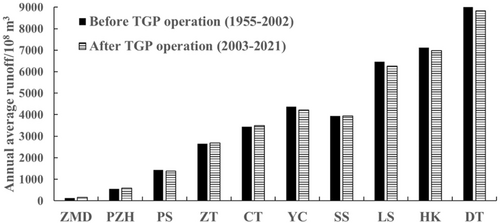
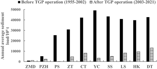
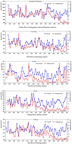
Different from changes in runoff, except for a significant increase of approximately 24.1% in the annual suspended sediment load at the Zhimenda station, the suspended sediment load in the upper reach of the Yangtze River and its tributaries has shown a significant decreasing trend since the 1990s for tributaries and since the impoundment of the TGR for the mainstream. Comparing the period of 1991–2002 with that before 1990, the annual average sediment load of the tributaries Min, Tuo, Jialing, and Wu River decreased by 34.4%, 68.2%, 72.2%, and 33.9%, respectively. Comparing the period of 2003–2021 with that of 1991–2002, except for a 61.8% increase in sediment load in the Tuo River, the sediment load in other tributaries further decreased. Specifically, the Min River and Jialing River decreased by 23.8% and 12.1%, respectively, with a reduced rate of decline, while the Wu River decreased by 78.4% with an increased rate of decline. The annual average sediment transport of the mainstream Jinsha River (at the Xiangjiaba station) decreased by 73.2%, comparing the period of 2003–2021 with that of 1991–2002. Particularly, after the operation of the Xiangjiaba, Xiluodu, Baihetan, and Wudongde cascade reservoirs in the lower reach of the Jinsha River, sediment transport sharply decreased, with an annual average sediment load decreasing from 281 million tons in the period of 1991–2002 to 1.47 million tons in the period of 2013–2021.
Due to the changes in the mainstream and tributaries, the inflow of water and sediment into the TGR (the sum of Zhutuo, Beibei, and Wulong stations) also underwent corresponding changes. From 2003 to 2021, the annual average runoff remained basically unchanged compared to the period of 1991–2002, while the sediment load decreased by 57.8%.
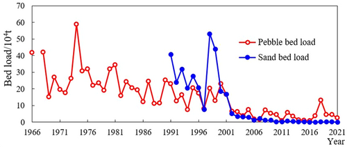
Similar to the changes in suspended sediment load, the reduction in bed load sediment is even greater. From 2003 to 2021, compared to the pre-2002 mean values, the annual average pebble bed load transport at the Zhutuo station decreased from 269,000 to 86,000 tons, a decrease of 68%. At the Cuntan station, it decreased from 220,000 to 42,000 tons (see Figure 8), a decrease of 81%. At the Wanxian station, it decreased from 341,000 to 120 tons, a decrease of 99.6%. The annual average sandy bed load transport at the Cuntan station from 2003 to 2021 was 9000 tons, a decrease of 97.8% compared to the pre-2002 mean value (412,700 tons).
The changes in sediment transport in the upper reach of the Yangtze River are influenced by various factors such as reservoir operation, soil and water conservation, rainfall, returning farmland to forest, and river sand mining. The weights of these factors vary at different stages. For example, the proportion of sediment reduction in the TGR due to sediment trapping was 53.4% from 1991 to 2005, 42.4% from 2006 to 2012, and 65.1% from 2013 to 2018. The significant increase in the annual average runoff at the Zhimenda station is likely related to factors such as upstream snow and ice melting, resulting in a corresponding significant increase in sediment transport.
The annual variations in flow and sediment load in the middle and lower reaches of the Yangtze River mainstream and major tributaries are shown in Figures 5, 6, and 9. After the operation of the TGP, the annual average runoff at most stations along the mainstream slightly decreased, ranging from 0.3% to 3.5%, except for the Jianli station, which increased by 6.3% compared to that before TGP operation. The tributaries of the Dongting Lake system and the Han River experienced greater reductions in runoff, by 15.9% and 9.2% respectively, while the Poyang Lake system had a smaller decrease of 1.2%. The suspended sediment load at all mainstream stations significantly decreased, with reductions ranging from 69% to 93%, and the percentage of reduction gradually decreased from upstream to downstream. The sediment discharge from Poyang Lake increased by 6.9%, while that from Dongting Lake decreased by 55.7% and the sediment from the Han River decreased by 63.8%.
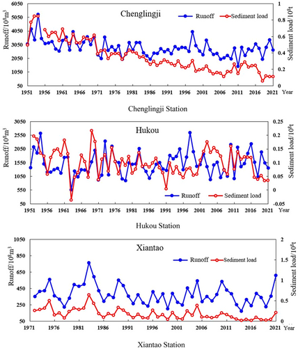
Similarly, the bed load sediment transport also significantly decreased. The annual average gravel and pebble bed load transport at the Yichang station decreased from 174,600 tons in the period from 1981 to 2002 to 18,900 tons in the period from 2003 to 2021, a decrease of 89.2%. From 2010 to 2021, the annual average is only 4200 tons, of which 6 years have not detected gravel and pebble bed load. The Zhicheng station only measured 22,000 tons of gravel and gravel bed load transport in 2012 and did not measure it in other years. From 2003 to 2021, the annual average sandy bed load transport at the Yichang station decreased to 54,000 tons, a decrease of 93.6% compared to the 1981–2002 average. The measured annual average sandy bed load transport at the Zhicheng and Shashi stations from 2003 to 2021 was 1,830,000 and 2,180,000 tons, respectively. From 2009 to 2021, the measured annual average sandy bed load transport at Jianli, Luoshan, Hankou, and Jiujiang stations was 3,150,000 (2008–2021), 1,620,000, 1,920,000, and 489,000 tons, respectively. It can be observed that the sandy bed load transport increases along the Yichang to Jianli reach but overall decreases along the Jianli to Jiujiang reach.
The significant reduction in sediment transport in the middle and lower reaches of the Yangtze River mainstream is mainly due to the significant decrease in sediment discharge from the upper reach. The annual average sediment transport at the Yichang station decreased from 492 million tons before the TGR impoundment to 33.7 million tons after a decrease of 93%. The outflow sediment from Dongting Lake and Poyang Lake and the sediment from the Han River were reduced by approximately 40 million tons annually. After the operation of the TGP, the sediment transport in the middle and lower reaches of the Yangtze River has increased along the channel due to erosion, with sediment transport at the Datong station averaging about 132 million tons per year, a decrease of 69% compared to that before the TGP operation.
2.2 Intra-annual variation
After the operation of water conservancy and hydropower projects, natural flow and sediment transport processes are altered to varying degrees. In general, the operation of large- and medium-sized water conservancy and hydropower projects on the Yangtze River leads to the flattening of downstream flow process, an increase in medium and low flow, prolongation of the duration of medium flow, reduction in flood peaks, significant decrease in sediment load, and a decrease in sediment grain size. Table 2 reflects the changes in flow discharge probabilities at different levels in the middle and lower reaches of the Yangtze River after the operation of the TGP.
| Station | Periods | <5000 m3/s | 5000–20,000 m3/s | 20,000–40,000 m3/s | >40,000 m3/s |
|---|---|---|---|---|---|
| YC | 1990–2002 | 22.0% | 55.2% | 19.8% | 3.0% |
| 2003–2021 | 7.3% | 73.3% | 17.9% | 1.5% | |
| SS | 1990–2002 | 18.2% | 63.6% | 16.5% | 1.7% |
| 2003–2021 | 4.3% | 80.5% | 15.0% | 0.2% |
| Station | Periods | <10,000 m3/s | 10,000–30,000 m3/s | 30,000–50,000 m3/s | >50,000 m3/s |
|---|---|---|---|---|---|
| LS | 1990–2002 | 22.3% | 55.9% | 17.9% | 3.9% |
| 2003–2021 | 18.9% | 61.9% | 18.3% | 0.9% | |
| HK | 1990–2002 | 15.6% | 59.3% | 19.4% | 5.7% |
| 2003–2021 | 7.9% | 64.3% | 24.1% | 3.7% | |
| DT | 1990–2002 | 5.0% | 52.6% | 30.3% | 12.1% |
| 2003–2021 | 0.7% | 59.4% | 33.4% | 6.5% |
- Abbreviation: TGP, Three Gorges Project.
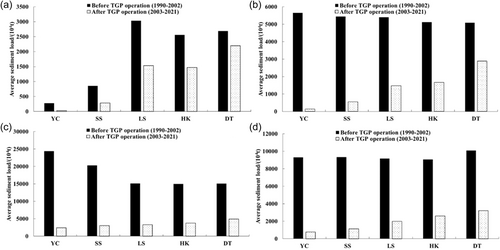
Figures 10 and 11 show the variations in average flow rate and sediment transport during four periods: dry season (December–April of the following year), falling stage (May–June), flood season (July–August), and impoundment period (September–November) before (1990–2002) and after (2003–2021) the impoundment of the TGR at various hydrological stations downstream of the dam.
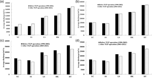
It can be observed from Figure 10 that after the impoundment of the TGR, the flow rate during the dry season significantly increased at various stations in the middle and lower reaches of the Yangtze River. The changes during the falling stage were relatively small, while both the flood season and the impoundment period showed noticeable reductions in flow rate. It should be noted that the inflow from the upstream and tributaries of the Yangtze River differs before and after the TGP operation. Therefore, the magnitudes of these changes can only be taken as references, but this pattern exists consistently.
Figure 11 demonstrates that, compared to the preimpoundment period, there is a clear decrease in average sediment load in the mainstream of the Yangtze River during the four periods after the impoundment of the TGR. The degree of recovery in average sediment load varies across the different periods. The average sediment load at the Datong station has recovered to the maximum extent during the dry season, reaching 82% of the preimpoundment levels between 2013 and 2021. However, the falling stage, flood season, and impoundment period exhibited recovery rates of 57%, 33%, and 32%, respectively, compared to the preimpoundment levels from 1990 to 2002.
2.3 Changes in flow-sediment source composition
It can be seen from Figure 12 that there is no significant increase or decrease in the proportion of inflow from the mainstream and main tributaries of the upper reach of the Yangtze River to the Cuntan station after the impoundment of the TGR. However, there is a noticeable change in the sediment composition. From 1961 to 1970, the Jinsha River and Jialing River accounted for 45.1% and 32.3%, respectively, of the sediment inflow to the Cuntan station. From 1991 to 2000, there was a significant reduction in sediment inflow from the Jialing River, leading to an increase in the proportion of sediment inflow from the Jinsha River by 17.6%, reaching 70%. The proportion of sediment inflow from the Jialing River decreased to 9.9%.

After the operation of the TGP, the proportion of sediment inflow from the Jinsha River to the Cuntan station decreased by 65.8% for the period from 2003 to 2012. Due to the successive impoundment and operation of reservoirs in the lower reach of the Jinsha River, such as Xiangjiaba Reservoir and Xiluodu Reservoir, the sediment inflow from the Jinsha River drastically decreased, and it accounted for only 1.7% of the sediment inflow to the Cuntan station for the period from 2013 to 2021. The Jinsha River is no longer the main source of sediment entering the TGR.
Meanwhile, the Jialing River, Min River, and the intermediate reaches became the main sources of sediment inflow to the TGR. From 2013 to 2021, the proportions of sediment inflow from the Jialing River, Min River, and the intermediate reaches increased to 42.9%, 26.9%, and 11.3%, respectively. The sediment inflow from the Wu River gradually decreased, with its proportion to the combined sediment load at Cuntan and Wulong stations decreasing from 5.3% in 1991–2000 to 3.5% in 2013–2021.
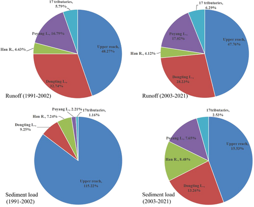
Before and after the impoundment of the TGR, the proportions of annual average runoff and sediment load to the Datong station from Yichang station, Dongting Lake, Poyang Lake, and 17 small tributaries (i.e., the Qing River, Juzhang River, Jinshui River, Fu River, Huan River, She River, Ju River, Ba River, Xi River, Qi River, Fu River, Wan River, Chaohu Lake, Qingyi River, Chu River, Shuiyang River, and Huai River inlet channel) are shown in Figure 13. After the impoundment of the TGR, except that the proportion of Dongting Lake outflow to the Datong station has decreased by 4.5%, the proportion of the upstream mainstream, Han River, Poyang Lake, and the 17 small tributaries has only slightly increased and decreased. The proportion of sediment load from Yichang station to Datong station decreased from 115.22% before TGR impoundment to 25.53% after impoundment. The proportion of sediment inflow from the Dongting Lake, Poyang Lake, Han River, and the 17 small tributaries has increased to varying degrees, especially the proportion of Poyang Lake and the 17 small tributaries is more than twice that before the impoundment. This indicates a significant change in the composition of flow-sediment sources in the middle and lower reaches of the Yangtze River after the operation of the TGP.
3 EVOLUTION OF THE YANGTZE RIVER
3.1 Changes in riverbed erosion and sedimentation
As mentioned above, a large number of water conservancy and hydropower projects have been built in the mainstream and tributaries of the Yangtze River. After the operation of these projects, the flow and sediment conditions and boundary conditions of the natural river channel have been changed and the relative equilibrium state has been broken. The sediment is trapped by the reservoirs, causing channel erosion in the downstream of the dams. The sedimentation in the reservoir area, erosion, and sedimentation in the downstream channel since the operation of Xiluodu, Xiangjiaba, and TGP in the mainstream of the Yangtze River were analyzed.
3.1.1 Reservoir sedimentation
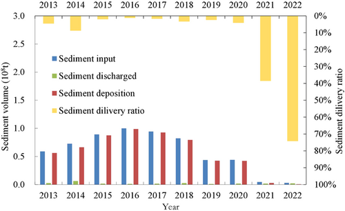
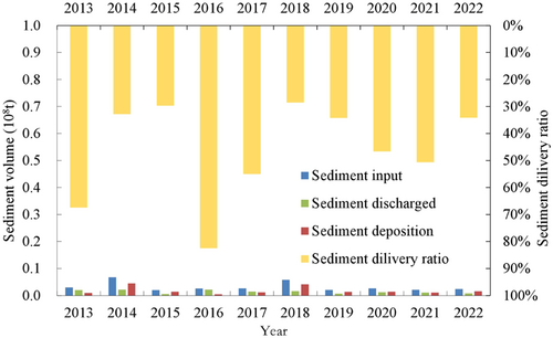
During the first 10 years since the impoundment of Xiangjiaba and Xiluodu reservoirs, the amount of the incoming sediment load has been greatly reduced compared with the design value, and the amount of reservoir sedimentation has been greatly reduced. Excluding the sediment yield within uncontrolled areas of the reservoirs, from May 2013 to December 2022, the sediment input of the Xiluodu Reservoir is 593 million tons, of which the amount of sediment discharged from the reservoir is 23.5 million tons and the amount of sediment deposition in the reservoir is 569.5 million tons. The average annual sedimentation volume is 0.57 million tons, and the sediment delivery ratio of the reservoir was 3.9% (see Figure 14). From January 2013 to December 2022, the Xiangjiaba Reservoir received 32.3 million tons of sediment, of which 14 million tons were discharged, and 18.3 million tons of sediment deposited in the reservoir, and the average annual sedimentation volume was 1.8 million tons, and the corresponding sediment delivery ratio was 43.6% (see Figure 15).
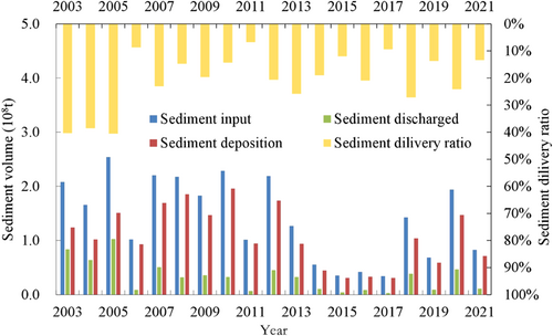
Similarly, the amount of sediment input of the TGR over the past 20 years has been greatly reduced compared with the preliminary design value, and the siltation in the reservoir also has been greatly reduced. Excluding the sediment yield within uncontrolled areas of the reservoir, from June 2003 to December 2012, 1.4378 billion tons of sediment was silted in the TGR, with an average annual siltation volume of 128.2 million tons, and the corresponding sediment delivery ratio of the reservoir was 23.9%. From January 2013 to December 2021, the amount of sediment deposition in the reservoir is 610.6 million tons, with an average annual siltation volume of 67.8 million tons, and the corresponding sediment delivery ratio was 18.7%. In the past 20 years (June 2003–December 2021), since the impoundment of the TGR, the average annual siltation volume in the reservoir is 110 million tons, which is only 33% of the value in the demonstration stage, which was predicted based on the incoming flow and sediment conditions of 1961–1970 series, and the corresponding reservoir sediment delivery ratio is 23.6% (see Figure 16). Based on the measured topographic data, the cumulative sediment deposition of the main channel in the reservoir area from March 2003 to October 2021 is 1.7835 billion m3, of which 69.4 million m3 of sediment was eroded in the fluctuating backwater area (from Jiangjin to Fuling section); the cumulative sediment deposition in the perennial backwater area is 1.8529 billion m3.
The amount of deposition in the reservoir flood control capacity is 164.8 million m3, accounting for 0.74% of the total flood control capacity of 22.15 billion m3.
3.1.2 Morphological evolution downstream of the dam
After the impoundment of reservoir, a large amount of sediment is trapped by the reservoir, resulting in a significant reduction in the amount of sediment discharged and a reduction in particle size, leading to erosion-dominated evolution in the river channel downstream of the dam.
- 1.
Morphological evolution downstream of the Xiangjiaba Reservoir
According to the measured cross-sectional data, from October 2012 to October 2021, the amount of cumulative eroded sediment (including river sand mining) for the reach from Yibin to Jiangjin with a length of 296 km downstream of the Xiangjiaba Reservoir was 139.17 million m3, of which the values for the subreach from Yibin to Zhutuo with a length of 233 km and the subreach from Zhutuo to Jiangjin with a length of 63 km were 79.29 and 59.88 million m3, respectively. The corresponding values in per unit river length were 340 and 950 thousand m3/km respectively. The subreach from Yibin to Zhutuo accumulated 4.46 million m3 of sediment from October 2015 to October 2017, 15.94 million m3 of sediment from October 2017 to October 2019, and all other periods were scoured. For the subreach from Zhutuo to Jiangjin, the amount of sediment deposition was 1.36 million m3 from October 2018 to October 2020, while all other periods were scoured.
- 2.
Morphological evolution downstream of the TGR
Before the operation of the TGP, the middle and lower reaches of the Yangtze River underwent corresponding scouring and silting changes with the variation of flow and sediment or the influence of local human activities (such as curve cut-off projects), but the river channel is overall in a quasiequilibrium state. For the bankfull channel, the average annual erosion amount for the reach from Yichang to Hukou was 6.3 million m3 during the period 1975–2002, while the average annual siltation for the reach from Hukou to Jiangyin from 1975 to 2001 was 4.9 million m3. The average annual erosion of the channel below 0 m elevation for the reach downstream Jiangyin during the period 1984–2001 was 2.5 million m3.
Since the impoundment of the TGR, the middle and lower reaches of the Yangtze River have undergone long-distance and long-duration erosion-dominated adjustment. The cumulative amount of erosion in the whole reach is 5.0296 billion m3 (including sand mining and dredging), and the corresponding average annual erosion intensity is 255.3 million m3, mainly occurring in the low water channel.
From October 2002 to April 2021, the accumulative erosion volume of the bankfull channel in the middle reach of Yangtze River from Yichang to Hukou was 2.6244 billion m3, with an average annual erosion intensity of 135 million m3. The distribution of erosion and sedimentation along the river indicates that the erosion in the reach from Yichang to Chenglingji is relatively severe, with a length of 408 km and an erosion volume of 1.4327 billion m3 in the bankfull channel, accounting for 55% of the total erosion volume. The erosion volume of bankfull channel for the reaches from Chenglingji to Hankou and from Hankou to Hukou was 502 and 689.8 million m3, respectively, accounting for 19% and 26% of the total erosion volume, respectively. The temporal variation of erosion shows that in the first 3 years after impoundment of the TGR (October 2002–October 2005), the erosion volume of the bankfull channel for the reach from Yichang to Hukou was 601 million m3, with an average annual erosion intensity of 182 million m3, and that was 15.4 million m3 in October 2005–October 2006, with the erosion intensity gradually weakened. The initial impoundment period of the TGR, from October 2006 to October 2008, the erosion volume of the bankfull channel for the reach from Yichang to Hukou was 9.1 million m3, with an average annual erosion intensity of 4.6 million m3. After the 175 m experimental impoundment of the TGR, its erosion intensity gradually increased, and from October 2008 to April 2021, the erosion volume of the bankfull channel was 1.999 billion m3, with an average annual erosion intensity of 153.8 million m3. The cross-sectional distribution of erosion shows that the floodplain and channel are all scoured, and the erosion is mainly concentrated in the low water channel, which accounts for 92% of the volume of the bankfull channel.
The channel in the lower reach of the Yangtze River is also dominated by erosion. From 2001 to 2021, the accumulative erosion volume for the Hukou–Xuliujing reach was 2.405 billion m3, with an average annual erosion intensity of 120 million m3, of which the scouring of Hukou to Datong reach was 522 million m3, with an average annual erosion intensity of 26.1 million m3. The erosion was mainly concentrated in the low water channel, accounting for 89% of the erosion amount of bankfull channel. The scouring intensity of this reach has an increasing trend. The accumulative erosion volumes for the subreaches from Datong to Jiangyin and from Jiangyin to Xulujing and the southern branch of the Yangtze River estuary were 1.184 billion m3, 617 million m3, and 395 million m3, respectively, and the corresponding average annual erosion intensity were 59.2, 30.9, and 19.8 million m3, respectively. However, the northern branch of the Yangtze River estuary silted 314 million m3 with an annual average siltation intensity of 15.7 million m3. The evolution characteristics of erosion in the southern branch and deposition in the northern branch of the Yangtze River estuary have not changed.
3.2 Riverbed evolution
3.2.1 The upper reach of the Yangtze River
The four cascade reservoirs (e.g., the Xiangjiaba Reservoir) in the lower reach of the Jinsha River have not been used for a long time. Although the sediment was deposited in the reservoir area, the cross-sectional shape is basically stable and has not changed significantly. The reach from Yibin to Jiangjin downstream of the Xiangjiaba Reservoir mostly flows through low mountain and hilly areas. After the operation of these reservoirs, the channel was scoured, yet the river regime did not change significantly.
The siltation of the TGR mainly occurs in curved, wide, and bifurcated reaches, such as the Luoqi-Changshou and Qingyanzi reaches in the fluctuating backwater area, as well as the Tunaozi, Lanzhuba, and Huanghuacheng reaches in the perennial backwater area, the overall river regime has not changed significantly. However, with the development of siltation, some river reaches have undergone certain changes in river regime, such as the Huanghuacheng reach. After the impoundment of the TGR, the left branch of Huanghuacheng as the upward waterway has been silted to 145 m elevation by 2011, threatening the navigation safety of ships, resulting in insufficient channel dimensions. The left branch navigation waterway was closed in July 2019. At present, the right branch channel is two-way navigation throughout the year.
3.2.2 The middle and lower reaches of the Yangtze River
The river pattern, riverbed boundary conditions, and tributary inflow conditions of each river section along the mainstream of the middle and lower reaches of the Yangtze River are different, and the degree of influence by the operation of upstream reservoir group is also different. Therefore, these river sections exhibit different evolutionary characteristics after the operation of the TGR.
- 1.
Evolution of straight channel
The morphology of the straight channels in the middle and lower reaches of the Yangtze River is mainly characterized by undulating riverbed longitudinal profiles and interlacing point bars on both sides. Under natural conditions, corresponding changes in erosion and deposition occur with the change of incoming flow and sediment conditions or the upstream river regime.
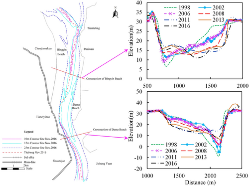
After the operation of the TGR, both the staggered point bars and the central bars in straight sections in the middle and lower reaches of the Yangtze River have experienced significant erosion and retreat, and part of the sediment deposited in the deep groove. It presents the evolution characteristics of “floodplain erosion and groove deposition” and “flow path straightening” during the low and medium flow periods. The swing magnitude of the mainstream increased significantly (see Figure 17), and the cross-sectional profile changed from V-shape to W-shape. The width–depth ratio of cross-sectional profile increases and the average water depth decreases under the low flow discharge.
- 2.
Evolution of meandering channel
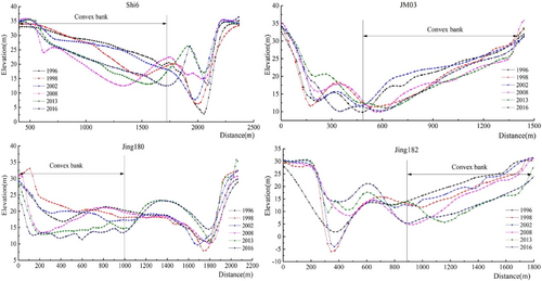
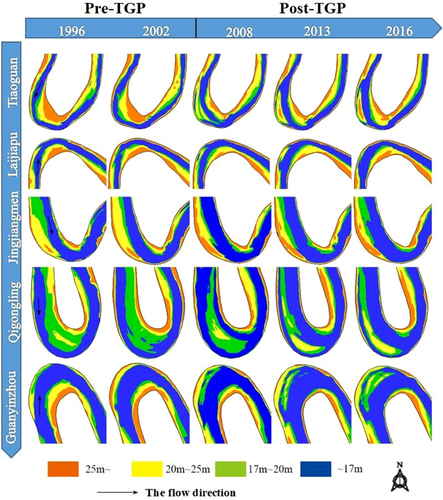
Under natural conditions, the mainstream line in the meandering channel is located near the concave bank in low discharge and in the middle in high discharge. The classic meander theory in quasi-equilibrium conditions is where erosion mainly occurs at the concave bank and deposition mainly occurs at the convex bank. For an excessively highly sinuous meander, natural curve cutoff may also occur under certain flow, sediment, and boundary conditions. After the operation of TGP and other reservoirs, the evolution of the meandering channel in the middle and lower reaches of the Yangtze River presents new characteristics. For river sections with a poor symmetry and large curvature, the convex bank of the upper section of the bend suffered bend bypassing and shoal cutting (i.e., chute cutoff). The cross-sectional profile changed from V-shape to W-shape (see Figures 18 and 19). For river sections with a good symmetry and small curvature, there may occur gradual shoal cutting in the convex bank near the top of the bend, and the cross-sectional profile changed from V-shape to U-shape. The flow condition and the shape of the river bend are the main factors affecting the flow dynamic axis. The greater the flow, the larger the curvature of the bend, and the more the mainstream swings toward the convex bank.
The operation of the TGP has changed the runoff process of downstream river, increasing the duration of medium flow levels and decreasing the duration of low flow levels. These changes provide dynamic conditions for erosion of convex banks and shoals. Under the action of low sediment flow, the erosion of the convex bank is difficult to recover within the year, the cumulative erosion gradually evolving into bend bypassing and shoal cutting. Under the current flow and sediment conditions, the mainstream of the bend in the future will still have a certain migration, and the bend is adjusted in an “abrupt” or “gradual” manner. After the occurrence of bend bypassing and shoal cutting, the shape of the bend will reach a new equilibrium state adapting to the new flow and sediment conditions.
- 3.
Evolution of anabranched channel
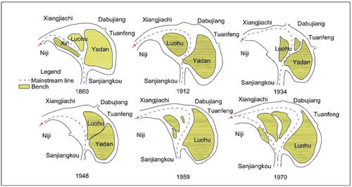
The anabranched channel in the middle and lower reaches of the Yangtze River can be further divided into three categories: straight branching, slightly curved branching, and curved branching. Under natural conditions, the evolution of anabranched channels in the middle and lower reaches of the Yangtze River is intense, and the erosion and deposition change greatly. The most significant feature is the main branch translocation, which presents two modes of “in situ translocation” and “displacement and alternations.” In the “in situ translocation” mode, the position of the main branch is basically unchanged, and only the flow distributary ratio changes, which generally occurs in straight branching channels and slightly curved branching channels, such as the Tianxingzhou branch in the Wuhan reach. In the “displacement and alternations” mode, subordinate branch expands into main branch through lateral displacement and cross-sectional erosion, usually occurring in curved branching rivers, such as the Wuguizhou branch, Luxikou branch, Luohuzhou branch, and Daijiazhou branch, and so on. (see Figure 20).
After the operation of the TGP, the central bar of the bifurcated river channel is mainly scoured, especially the shrinkage of the central bars with medium and low elevations is obvious. However, the variation degree of flow and sediment conditions in different reaches is different, resulting in a certain difference in the evolution of the bifurcated river channel. For example, the flow distributary ratio of the short subordinate branch in the straight and curved branches of the Jingjiang River has developed to varying degrees, but the bifurcated section with a large difference in flow distributary ratio downstream of Chenglingji shows the evolution characteristics of dominant development of main branch. For the bifurcated section with great difference in flow distributary ratio, translocation of the main branch basically will not occur. For the straight or slightly curved bifurcated section with little difference in the flow distributary ratio, there is still a possibility of translocation.
4 TREND OF RIVERBED EROSION AND DEPOSITION
4.1 Variation trend of water and sediment conditions
With the operation of a large number of reservoirs in the mainstream and tributaries of the Yangtze River, it is expected that the flow and sediment entering the mainstream of the Yangtze River will further change greatly. To predict the future trend of flow and sediment conditions, considering the sediment trapping effect of 30 built, under construction, and planned control reservoirs in the mainstream of the middle and lower reaches of the Jinsha River and tributaries of the Yalong, Min, Jialing, Wu, and other tributaries, the long-term prediction and calculation of sediment deposition in cascade reservoirs in the upper reach of the Yangtze River were carried out using the self-developed mathematical model based on the flow and sediment series from 1991 to 2000. The latest optimized dispatching mode is adopted for the operation of each reservoir, with the calculation starting year being 2020. According to the measured data, the average annual runoff of Yichang station from 1991 to 2000 was 433.6 billion m3 and the average annual sediment load was 417 million tons. Considering the joint operation of the above cascade reservoirs, the sediment discharge from the TGR will be greatly reduced, with an average annual sediment discharge of approximately 14.6 million tons in the first 10 years. As the service life of the cascade reservoirs increases, the sediment discharge from each reservoir gradually recovers. According to the above calculation and the estimation of sediment production in the uncontrolled areas of the reservoirs, it is expected that the average annual sediment input of the TGR in the next 30 years will be about 110 million tons. The average annual sediment load of Yichang station is estimated to be 0.24–0.34 million tons, with an average value of about 0.3 million tons, according to the predicted sediment delivery ratio of 22%–31% of the TGR. The average annual sediment supply from erosion of the middle and lower reaches of the Yangtze River channel is about 70 million tons, and that of the Dongting Lake, Poyang Lake, and Han River is about 25 million tons. In the next 30 years, the average annual sediment load of Datong station is about 125 million tons, and the maximum value may still reach about 250 million tons.
4.2 Trend of riverbed evolution
4.2.1 Reservoir deposition
Using the mathematical model for joint operation of cascade reservoirs in the upper reach of the Yangtze River, the sedimentation process of each reservoir is calculated. The results show that the time required to reach the relative equilibrium state for reservoirs of Wudongde, Baihetan, Xiluodu, Xiangjiaba, and Three Gorges in the upper reach of the Yangtze River is about 160, 240, 240, 260, and 370 years, respectively, and the corresponding cumulative sedimentation volumes are about 4, 15, 7.8, 3.9, and 16.2 billion m3, respectively (see Figure 21 and Table 3). When sedimentation is relatively balanced, the availability rates of flood control storage capacity in each reservoir are about 61.7%, 37.4%, 67.0%, 68.6%, and 86.9%, respectively. The availability rates of regulation storage capacity are about 55.6%, 28.9%, 53.3%, 68.6%, and 90.8%, respectively. The availability rates of total storage capacity are about 28.6%, 15.6%, 28.9%, 19.6%, and 60.4%, respectively. At the end of 10, 50, and 100 years, the availability rates of flood control storage capacity of the TGR are 99.2%, 98.4%, and 97.4%, respectively, that of regulation storage capacity are 99.5%, 99.2% and 98.8%, respectively, and that of total storage capacity are 94.6%, 90.9% and 86.5%, respectively.
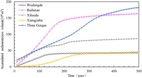
| Reservoir | Relative equilibrium time (year) | Relative equilibrium sedimentation (108 m3) | The availability rates of storage capacity (%) | ||
|---|---|---|---|---|---|
| Flood control storage | Regulation storage | Total storage | |||
| Wudongde | 160 | 39.89 | 61.7 | 55.6 | 28.6 |
| Baihetan | 240 | 149.9 | 37.4 | 28.9 | 15.6 |
| Xiluodu | 240 | 78.27 | 67.0 | 53.3 | 28.9 |
| Xiangjiaba | 260 | 38.54 | 68.6 | 68.6 | 19.6 |
| Three Gorges | 370 | 161.9 | 86.9 | 90.8 | 60.4 |
4.2.2 Channel erosion downstream of TGP
Based on the discharged flow and sediment conditions from the TGR calculated using series from 1991 to 2000 under the operation of the upstream cascade reservoirs, the trend of riverbed erosion and deposition in the middle and lower reaches of the Yangtze River from Yichang to Datong in the next 30 years is predicted and analyzed by using the self-developed flow and sediment mathematical model. The results show that under the joint operation of the reservoir group, the main channel of the middle and lower reaches of the Yangtze River will generally show a trend of erosion in the next 30 years. Except for the reach from Yichang to Zhicheng, which basically reaches the equilibrium state of erosion and deposition, other reaches are still in the state of erosion. By the end of 2050, the cumulative erosion volume of suspended load in the reach from Yichang to Datong of the Yangtze River is about 3.58 billion m3 (see Table 4), of which the average annual erosion volume in 2021–2035 and in 2036–2050 are 134 and 105 million m3, respectively, which are both less than the measured value from 2002 to 2020 of 175 million m3.
| Subreach | Length (km) | Measured data (108 m3) | Predicted data (108 m3) | |
|---|---|---|---|---|
| October 2002–October 2020 | 2021–2035 | 2021–2050 | ||
| Yichang–Zhicheng | 60.8 | −1.65 | −0.15 | −0.15 |
| Zhicheng–Chenglingji | 347.2 | −12.29 | −7.56 | −13.68 |
| Chenglingji–Hankou | 251 | −5.70 | −3.74 | −6.08 |
| Hankou–Hukou | 296 | −7.14 | −4.95 | −8.13 |
| Hukou–Datong | 204 | −4.81 | −3.65 | −7.77 |
| Yichang–Hukou | 955 | −26.78 | −16.41 | −28.03 |
| Yichang–Datong | 1183 | −31.59 | −20.06 | −35.80 |
5 CONCLUSIONS
Based on the measured data, the evolution law of flow and sediment, and erosion and deposition in the main channel of the Yangtze River was analyzed. Based on the mathematical model, the trend of erosion and deposition in the main channel of the Yangtze River in the next 30 years was predicted. The conclusions are as follows:
- 1.
Under natural conditions, the runoff and sediment load of the mainstream and tributaries of the Yangtze River mainly change with the change of rainfall, without a systematic increase or decrease trend. Since the 1990s, due to the impact of human activities such as soil and water conservation, operation of water conservancy and hydropower projects, as well as climate change, the incoming flow and sediment conditions of the mainstream and tributaries of the Yangtze River have changed significantly, including the obvious increase of flow and sediment in the source region of the Yangtze River, the small change of runoff in other parts of mainstream and tributaries, the obvious flattening of runoff process affected by reservoir regulation and storage, the increase of medium and low flow, the extension of medium flow duration, and the reduction of flood peaks. The sediment discharge in the mainstream and tributaries has significantly decreased.
- 2.
The original relative equilibrium state of the main channel of the Yangtze River has been broken by human activities such as the construction and operation of a large number of water conservancy and hydropower projects, causing riverbed reconstruction. The river channel in the reservoir area of the upper Yangtze River has changed from erosion under natural conditions (the wide section of the channel changes with the change in flow and sediment conditions over the years) to accumulation evolution. After the operation of the TGR from 2003 to 2021, the cumulative sediment deposition in the reservoir area reached 2.048 billion tons, of which 69.4 million m3 of sediment was eroded in the fluctuating backwater area (from Jiangjin to Fuling), and 1.8529 billion m3 of sediment was accumulated in the perennial backwater area. The sediment accumulation within the reservoir's flood control capacity accounted for 0.74% of the flood control capacity. The middle and lower reaches of the Yangtze River have shifted from a relatively equilibrium state to a long-distance and long-term erosion-dominated reconstruction process. The cumulative erosion of the middle and lower reaches of the Yangtze River is about 5.03 billion m3 (including sand mining and channel dredging). The erosion mainly occurs in the low water channel. From October 2002 to April 2021, the bankfull channel in the middle reach of Yichang to Hukou was eroded by 2.6244 billion m3, of which the amount of low water channel erosion accounts for 92%. Presently, the subreach from Yichang to Yangjianao has basically reached a relatively equilibrium state of erosion and deposition.
- 3.
Since the operation of control projects such as the TGR, the river regime of the mainstream of the upper reach of the Yangtze River has been basically stable. Only the local section of the fluctuating backwater area and the upper part of the perennial backwater area of the TGR have changed with the development of sediment deposition. The overall river regime of the middle and lower reaches of the Yangtze River has not changed, but the river regime of some local sections has been adjusted and changed. For example, the meandering river section from Xiongjiazhou to Chenglingji in the tail section of the Jingjiang River shows the obvious phenomenon of bend bypassing and shoal cutting (i.e., chute cutoff).
- 4.
Due to the large reservoir capacity of the mainstream and tributaries of the Yangtze River, it takes a long time to reach relative equilibrium. Therefore, the sediment transport in the channel downstream of the TGR will be in an unsaturated state for a long time in the future. The erosion and deposition changes and riverbed reconstruction will continue for a long time and have a profound impact. After years of river regulation and waterway improvement, the plane shape of the river channel has been mostly controlled. It is expected that the overall river regime of the middle and lower reaches of the mainstream will be basically stable in the future. However, some long straight sections, curved sections with large curvature, and multibranching sections will still undergo certain adjustments in the river regime, and local river regime changes may be relatively severe.
- 5.
The evolution of rivers, lakes, reservoirs, and estuaries in the Yangtze River Basin is affected and constrained by both natural factors and human activities, which is very different from the evolution under natural conditions. The evolution under the influence of human activities is more complex and varied, and the evolution and its impact are gradually developing and will continue for a relatively long time. Therefore, continuous observation and long-term tracking research are needed to timely control the river regime and manage the river channel.
ACKNOWLEDGMENTS
This study was financially supported by the Changjiang Water Science Research Joint Fund of the National Natural Science Foundation of China (U2240206, U2240224), the Research Project on Major Scientific and Technological Issues in Watershed Water Management of MWR of China (CKSC2020791/HL), the Fundamental Research Funds for Central Public Welfare Research Institutes of China (CKSF2023328/HL), the Key Laboratory of Water-Sediment Sciences and Water Disaster Prevention of Hunan Province of China (No. 2021SS01), and Natural Science Foundation of Hubei Province (2021CFB146) of China.
ETHICS STATEMENT
None declared.
Open Research
DATA AVAILABILITY STATEMENT
The data that support the findings of this study are available from the corresponding author upon reasonable request.


