Sedimentation and regulation technologies in the Three Gorges Reservoir
Abstract
Sedimentation is one of the key technical problems present throughout feasibility demonstration, design, construction, and operation of the Three Gorges Project. Since the Three Gorges Reservoir (TGR) began impoundment operation in 2003, important progress has been made in sedimentation and regulation technologies through systematic research and practices. This paper reveals the asynchronous propagation pattern of flood and sediment peak inflows, sediment movement in the backwater area during drawdown period, sediment flocculation, and sediment deposition that compromises the flood control reservoir storage, and puts forward new sediment regulation techniques, including sediment peak discharge regulation during flood season, siltation reduction in the backwater area during drawdown period, dynamic adjustment of the reservoir level during flood season, and joint sediment regulation in cascade reservoirs. A real-time monitoring, forecasting and dynamic regulation platform for water and sediment inflow in the TGR was developed; a new mode of dynamic sediment regulation called “regulating sediment for greater benefits” is proposed, which addresses the constraints of sedimentation on the optimal operation of TGR. By enabling more flexible operation, this mode improves the process and pattern of sedimentation, ensures the safety of reservoir operation, and significantly augments the comprehensive benefits of the TGR.
1 INTRODUCTION
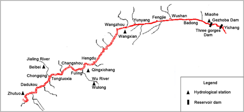
The Three Gorges Water Conservancy Complex is a vital backbone project for the development and management of the Yangtze River. Its operation purposes include flood control, power generation, navigation, and water resource utilization. The Three Gorges Reservoir (TGR) has a storage capacity of 39.3 billion m³ at the normal water level of 175 m. The storage capacity for flood control is 22.15 billion m³, within the range from flood control level (145 m) to normal water level (175 m). The reservoir performs seasonal storage regulation. At the 175 m level, its backwater area can stretch for about 660 km long, covering the 500 km-long permanent backwater area from the Dam site to Fuling, and the 160 km-long fluctuating backwater area from Fuling to Jiangjin, as shown in Figure 1.
Sediment is one of the key technical problems of the Three Gorges Project (TGP), affecting reservoir size and service life, operation mode, inundation in the reservoir area, channel change, and the realization of its benefits. At the stage of feasibility demonstration and preliminary design, the mode of “storing clean water and discharging muddy flow” was adopted for TGR (C. H. Hu & Fang, 2017). Under this mode, three operational water levels (175, 155, 145 m) were exercised. In early June each year, the upstream water level was drawn down to the flood control level of 145 m, and operated at this level from mid-June to September during flood season. At the end of flood season in October, the reservoir level gradually rose to 175 m, and kept at or above the 155 m level till the end of next April to ensure the head for power generation and necessary navigable channel depth upstream of the reservoir. It was believed that the approach of “storing clean water and discharging muddy flow” can bring the reservoir into full play while addressing the sediment problem.
In June 2003, TGR began to impound water (T. Hu et al., 2014) and started power generation at the cofferdam. It entered the initial operation stage in 2006, and began the 175 m trial impoundment in 2008, 5 years earlier than designed. In 2020, it started normal operation after being fully completed and accepted by review.
Since TGR began operation, sediment inflow has reduced drastically amid growing requirements for reservoir operation from water supply, flood control, and downstream navigation. To scale up TGP's comprehensive benefits, the TGP Sediment Expert Group mobilized more than 10 agencies in China to carry out research on TGR sediment problem (Pan, 2017). Important results have been achieved in exploring the sediment transport and deposition patterns, and developing sediment forecasting and regulation technologies. Sedimentation hence no longer posed major constraint to the functioning of TGR because of the optimized mode of “storing clean water and discharging muddy flow” and a dynamic regulation featuring of “regulating sediment for greater benefits.” Significant social, ecological, and economic benefits have been produced. This paper systematically expounds and summarizes the laws of sediment transport and the technologies and applications of sediment regulation in TGR, as a reference for related research on reservoir operation and management.
2 OPERATION AND SEDIMENTATION IN TGR
2.1 Runoff and sediment inflow changes
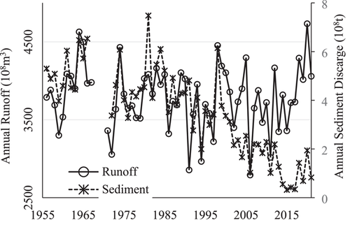
According to the long-term observations of sediment changes in TGR, the interannual (1950–2021) runoff inflow averages 429.7 billion m3; the interannual (1953–2021) sediment inflow averages 405 million tons; and the interannual sediment concentration averages 0.94 kg/m3. Measured data indicates that from the 1990s onward, runoff inflow to the reservoir had no notable changes, but sediment inflow reduced sharply due to interception by upstream reservoirs (Chen & Wang, 2019). Figure 2 shows the interannual variations of runoff and sediment inflow to TGR at Zhutuo station on the main-stem, at Beibei station on the Jialing River, and at Wulong station on the Wujiang River. Since the impoundment at TGR, the average annual runoff inflow decreased by 2.8% and the average annual sediment discharge dropped by 70.6% during 2003–2021, compared with the period from 1956 to 1990.
Bed load sediment inflow to TGR has tended to shrink since the 1980s. The average annual bed load sediment inflow to the reservoir at Cuntan station was measured to be 413,000 tons from 1991 to 2002, and 53,000 tons from 2003 to 2021, showing a decline of about 87%.
It should be noted that since impoundment began in 2003, runoff inflow is becoming more and more evenly distributed within the year, but sediment inflow becomes more concentrated. In particular, more sediment inflow is carried by several heavy rainstorms and floods during the flood season, sometimes with sediment inflow carried by these events accounting for over 80% of the annual total.
2.2 TGR operation and its sedimentation
Measured data reveals that from June 2003 to December 2021, sediment deposition in TGR reached 2.05 billion tons, the average annual deposition was 110 million t/a, and the average sediment discharge ratio was 23.6%. Table 1 shows sediment inflow, outflow, and deposition in TGR at different stages of operation since impoundment operation.
| Stage (mm/yy) | Average annual sediment volume (108t/a) | Sediment discharge ratio (%) | ||
|---|---|---|---|---|
| Inflow | Outflow | Deposition | ||
| 2003.06–2006.08 (cofferdam power generation) | 2.155 | 0.797 | 1.358 | 37.0 |
| 2006.09–2008.09 (initial operation) | 2.129 | 0.399 | 1.730 | 18.8 |
| 2008.10–2021.12 (175 m trial impoundment) | 1.160 | 0.219 | 0.941 | 18.9 |
| 2003.06–2021.12 | 1.442 | 0.340 | 1.102 | 23.6 |
- Abbreviation: TGR, Three Gorges Reservoir.
TGR has undergone three stages of operation since impoundment. From June 2003 to August 2006, cofferdam was used for power generation. The reservoir operated at a water level of 135 m (flood control level) to 139 m (water impoundment level), with an average water level of 137.22 m during flood season and an average sediment discharge ratio of 37.0%. From September 2006 to September 2008, the reservoir entered initial operation. The water level fluctuated from 144 to 156 m, and averaged 146.07 m during flood season. With the rise of water level since operation, the average sediment discharge ratio dropped to 18.8%. At the end of the 2008 flood season, the reservoir kicked off the 175 m trial impoundment. Since then, the operation mode has been refined and adjusted several times (C. hu, Fang, et al., 2019). Postflood impoundment was advanced from October 1 to September 15 in 2009, allowing water level to rise to 146.5 m during flood season. The impoundment time was further moved forward to September 10 at the end of the flood season in 2010 so that a larger water level range was allowed for floodwater dispatch during small and medium-sized floods. In 2012, experiments were carried out to reduce sedimentation in the backwater area during drawdown period and on sediment peak inflow regulation during flood season, which yielded good results. At the stage of 175 m trial impoundment, the average water level during flood season increases markedly compared with the initial operation stage, averaging 151.34 m from 2009 to 2021. At the same time, the average sediment discharge ratio remains basically the same at 18.9%.
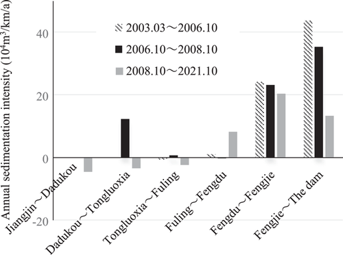
According to measured cross-section data, the fluctuating backwater area was generally scoured from 2003 to 2021, with cumulatively 0.69 billion m3 of sediment being scoured (sand mining included). Sedimentation mainly took place in the permanent backwater area downstream of Fuling, reaching 1.853 billion m3 in total. Sedimentation in the main-stem and tributaries that takes up storage capacity for flood control amounted to 165 million m3, accounting for about 8% of the total sedimentation in the reservoir area. Figure 3 shows the intensity of scouring and silting in the main-stem reservoir area at different operation stages since impoundment. In general, compared with initial design expectations, sedimentation is more concentrated in the middle and lower sections of the permanent backwater area, denoting an improvement in the sedimentation pattern (C. Hu 2019; Li et al., 2018).
3 THEORETICAL BASIS FOR SEDIMENT REGULATION IN TGR
Based on water and sediment data measured since TGR's impoundment, systematic research has been conducted on the pattern of sediment transport in the reservoir area (N.-hu. Dong et al., 2010, Tang et al., 2021), and revealed the laws of asynchronous propagation of flood and sediment peaks, sediment movement in backwater area during drawdown periods, flood-time sediment deposition, and sediment flocculation, hence providing a theoretical basis for reservoir sediment regulation.
3.1 Law of asynchronous propagation of flood and sediment peaks
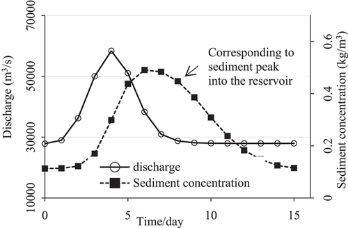
After the reservoir was impounded, due to raised upstream water level, flood in the reservoir area travels in the form of gravity wave at a faster speed than normal. However, suspended sediment transport slows dramatically as the flow velocity decreases, and thereby lags far behind flood propagation (N.-H. Dong et al., 2010). Such time lag in flood and sediment peak propagation is mainly related to peak flow, reaching about 3–5 days of time lag at high flows and even longer at low flows and when upstream water levels are high. There are also significant morphological changes in sediment peak into and out of the reservoir, prolonging the sediment peak. Sediment concentration in front the dam reaches the maximum generally before the arrival of the inflow sediment peak. Figure 4 shows the process of discharge flow and sediment concentration in the case of synchronous incoming flood and sediment peaks.
In addition, the frequency of asynchronous water and sediment inflow to TGR has increased due to the heterogeneity of water and sediment in the upstream of Three Gorges and the influence of cascade reservoirs on the main-stem and tributaries on water and sediment transport. Before the reservoir was impounded, the frequency was 33%, 49%, and 18%, respectively for sediment peak arriving ahead of flood peak, synchronous with flood peak, and later than flood peak, and becomes 35%, 24%, and 41% after 2012.
3.2 Pattern of sediment movement in backwater area
Before TGR's 175 m trial impoundment, the Chongqing section in the head of the reservoir was in its natural state: predominately silting up during flood season and being scoured from mid-September to mid-October (C. Hu, 2019). As a result of the 175 m trial impoundment, postflood sedimentation dominates the Chongqing section, and sediment discharge takes place mainly in the preflood drawdown period in the next year. During initial and early drawdown, the water level declines rather slowly, sediment largely deposits due to the jacking effect in the upper and middle reaches of the fluctuating backwater area. In the late drawdown period with fast water level decline, scouring takes hold as water surface slope and flow velocity increases. Sediment is discharged mainly from late April to late May. Main factors influencing sediment movement in the head of the reservoir include upstream incoming water and sediment conditions, bed material composition, the deposition situation of the river section in the early stage, water level of the reservoir and its decline rate. Table 2 shows the indicators of sediment movement in the head of the reservoir.
| River section | Flow at Cuntan station (m3/s) | Reservoir water level (m) | Sediment movement |
|---|---|---|---|
| Chongqing proper | <4000 | >173.0 | Siltation |
| 4300→4500 | 173.0→168.0 | Start of sediment movement, which is larger at low water levels | |
| 4500→5500 | 168.0→163.0 | Enhanced sediment movement capacity | |
| >5500 | <163.0 | Obvious scouring | |
| Tongluoxia-fuling | <4300 | >169.3 | Siltation |
| 4300→4700 | 169.3→164.0 | Start of sediment movement, which is larger at low water levels | |
| 4700→6700 | 164.0→161.0 | Enhanced sediment movement capacity | |
| >6700 | <161.0 | Significant sediment transport to the downstream river sections |
3.3 Pattern of sediment flocculation
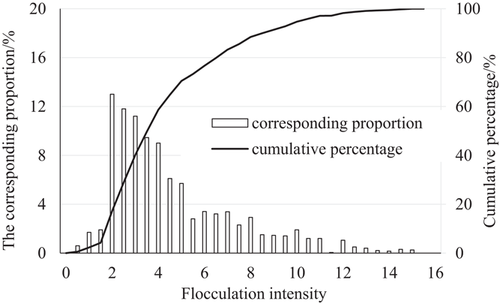
Observations and field experiments conducted after TGR was impounded indicate sediment flocculation in the reservoir area (N.-hu. Dong et al., 2010). It has a significant impact on the transport and deposition of sediment in the reservoir, for which it should be considered as one of the important factors in mathematical models and other studies. Favorable conditions for flocculation include sediment particle size smaller than 0.02 mm, water flow slower than 0.7 m/s, and sediment concentration larger than 0.30 kg/m3. Field observations and experiments suggest that when flocculation occurs in TGR, the diameter of about 85% of the floccules are 2–8 times that of single particles, as shown in Figure 5 (Wang et al., 2016). Flocculation leads to a substantial increase in the settling velocity of fine-grained sediment, thereby affecting sediment discharge ratio of the reservoir.
3.4 Pattern of sedimentation taking up reservoir storage for flood control
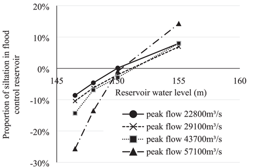
Sediment deposition that takes up the storage capacity for flood control during different typical flood processes is examined. The results indicate that sediment is slightly trapped or even washed out if the sediment discharge ratio during a flood process is large, and sedimentation intensifies in the case of small sediment discharge ratio. Figure 6 shows the mathematical model simulation results of relationship between the proportion of silt in the flood control capacity to the total silt volume of the reservoir and upstream water level during typical floods. An upstream water level of 150 m is the critical water level for sedimentation to take place within the reservoir storage for flood control. When the upstream water level is below 150 m, sediment generally deposits in the dead storage, and at high flows, scouring may even occur in the reservoir storage for flood control. When the upstream water level is above 155 m, sedimentation occurs expansively within the reservoir storage for flood control, representing 6.9%–14.3% of the total sediment silted in the reservoir.
4 TGR OPERATION MODE OPTIMIZATION AND THE REGULATION MODE OF “REGULATING SEDIMENT FOR GREATER BENEFITS”
Based on the understanding of the pattern of sediment transport, combined with real-time sediment monitoring and forecasting, sediment regulation technologies under different water and sediment conditions are proposed, which improves and upgrades the TGR operation mode from “storing clean water and discharging muddy flow” to “regulating sediment for greater benefits.”
4.1 Sediment regulation techniques
During feasibility demonstration and preliminary design, it was proposed that TGP should be operated to “store clean water and discharge muddy flow.” Specifically, during the muddy flood season, under the condition of not preventing flooding for the sake of the middle and lower reaches of the Yangtze River, the reservoir level should remain at the flood control level of 145 m so as to encourage sediment discharge from the reservoir. During the non-flood season when water is clearer, the reservoir level shall rise to 175 m water level starting from early October. While sticking to the basic principle of “storing clean water and discharging muddy flow,” new sediment regulation techniques have been developed since TGR was impounded, to optimize operation mode, reduce sediment deposition, and improve sedimentation pattern. These techniques include sediment peak regulation during flood season, sedimentation reduction in backwater area during drawdown periods, and joint sediment regulation of cascade reservoirs.
4.1.1 Sediment peak regulation during flood season
Sediment peak regulation during flood season aims to maximize sediment transport out of the reservoir by adjusting outflow at major water conservancy projects according to water and sediment inflow conditions while considering propagation speed differences between flood peak and sediment peak. To activate sediment peak regulation, the peak sediment concentration inflow should be greater than 2.0 kg/m3 and the corresponding water inflow at Cuntan station greater than 25,000 m3/s, and the estimated regulated outlet sediment concentration shall exceed 0.5 kg/m3. Sediment peak regulation consists of three stages: retaining flood and shaving peak, pulling sediment movement in the reservoir area, and discharging sediment out of the reservoir. The first stage intends to reduce the pressure of flood control downstream by retaining flood and shaving peak. The second stage works to maintain the smooth propagation of sediment peak to river sections upstream of the dam, most effectively by starting to pull the movement on the third day after flood peak enters the reservoir. The third stage is to increase outflow when the sediment peak arrives at the dam, so as to facilitate concentrated sediment discharge. The outflow can be raised as large as possible based on real-time observation and forecast of sediment peak while taking into account factors such as flood control, navigation, and flood resource utilization.
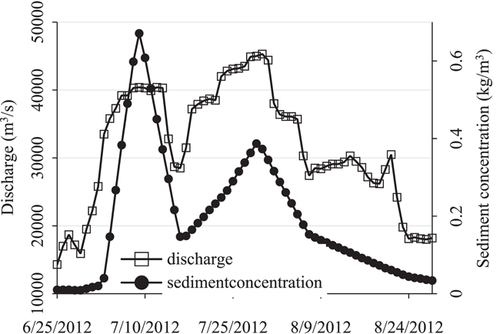
In the 2012 flood season, TGR carried out sediment peak regulation twice. The first regulation lasted from late June to early July as a sediment peak formed at Cuntan station (peaking on July 2). On July 5, the average daily outflow increased to 41,000 m3/s, carrying much more sediment out of the reservoir. On July 7, the outgoing sediment peak reached 0.607 kg/m3. The second sediment peak regulation took place when sediment peak appeared at Cuntan station on July 24. Figure 7 shows the changes of outflow and sediment concentration during sediment peak regulation in the 2012 flood season (B. Dong et al., 2014). Such regulation achieved remarkable sediment discharge effects by basically synchronizing the processes of outflow and sediment concentration. The average sediment discharge ratio in July 2012 rose to 28%, far outperforming other years. In addition, through sediment peak regulation amid joint operation of cascade reservoirs, the TGR sediment discharge ratio reached 31% in July 2018.
4.1.2 Sedimentation reduction regulation in backwater area during drawdown periods
Sedimentation reduction regulation is to regulate the reservoir drawdown so as to encourage scouring in the fluctuating backwater area according to water and sediment inflow conditions, so that deposited sediment is flushed as much as possible to the permanent backwater area. Such regulation is activated when appropriate under the conditions of upstream water level at 160–162 m and flow at Cuntan station larger than 5000 m3/s, to bring down water level by 0.4–0.6 m per day on average, as shown in Table 3 (M. Zhou et al., 2015). Where necessary, joint operation of TGR and upstream cascade reservoirs can be employed to create suitable flow conditions at Cuntan station.
| Timing | Regulation indicators | |||
|---|---|---|---|---|
| Time | Flow at Cuntan station (m3/s) | Upstream water level (m) | Daily average decline (m) | Duration (d) |
| Early and mid-May | 5000~7000 | 160~162 | 0.4~0.6 | ≥11 |
- Abbreviation: TGR, Three Gorges Reservoir.
Post-2012 sedimentation reduction regulation has rendered desired results. For example, during the 2019 drawdown period, the average inflow at Cuntan station in early May was about 6300 m3/s, and through sedimentation reduction regulation, the upstream water level fell at a daily rate of about 0.4 m from close to 160 m. Monitoring results indicate that the sedimentation reduction regulation from May 2 to 9 removed 1.441 million m3 of sediment from the Chongqing proper section, and 4.031 million m3 from the Fuling-Tongluoxia section, marking the largest reduction of sediment in backwater area during drawdown periods.
4.1.3 Dynamic water level adjustment during flood season
To improve the flexibility of operation and maximize the comprehensive benefits of the reservoir, water level regulation is carried out according to the aforementioned law of sediment transport and deposition in the reservoir. Under the premise of controllable flood risk, upstream water level should be kept below 150 m as much as possible when the sediment concentration of the incoming flood is high, to reduce sedimentation in the reservoir storage for flood control. When there is a low sediment concentration in the inflow, the water level of the reservoir can be raised as appropriate and there is less impact on sedimentation in the reservoir storage for flood control. Since sedimentation control has impact on the use of reservoir water resources, it is necessary to keep the sediment discharge ratio within an appropriate range, considering both the sedimentation reduction and the improvement of comprehensive benefits of the reservoir. Table 4 shows the target values for sediment discharge ratio control in cases of different typical floods. In general, the sediment discharge ratio increases with the flow of flood peak. The ratio is about 15%∼17% for flows at 30,000m3/s, 32%~36% for flows at 45,000 m3/s, and 39%∼42% for flows at 60,000 m3/s.
| Flow and sediment parameters at Cuntan station | |||
|---|---|---|---|
| Typical floods (year) | Flow rate of flood peak (m3/s) | Sediment concentration of flood peak (kg/m3) | Sediment discharge ratio range |
| 2016 | 22,800 | 2.06 | 10%~11% |
| 2017 | 29,100 | 1.79 | 15%∼17% |
| 2013 | 44,100 | 5.45 | 32%∼36% |
| 2018 | 57,100 | 4.66 | 39%∼42% |
- Abbreviation: TGR, Three Gorges Reservoir.
4.1.4 Joint regulation of sediment in cascade reservoirs
To maximize the effect of sediment regulation of TGR, the upstream cascade reservoirs are regulated in conjunction with TGR (Lu & Zhao, 2021) to create suitable water and sediment conditions for sediment peak control in flood season and siltation reduction at the backwater area of reservoir, as shown in Table 5. The joint sediment regulation of cascade reservoirs can strengthen the regulation effects. In particular, the siltation reduction regulation at the backwater area of reservoir could transport more sediment deposited in the fluctuating backwater area to the permanent backwater area.
| Regulation | Discharge increase from upstream reservoirs | |
|---|---|---|
| Days in advance | Increase of discharge (m3/s) | |
| Sediment peak regulation for sediment discharge | 2–3 | 3000∼5000 |
| Siltation reduction regulation in the backwater area | 3 | 400∼800 |
4.2 Real-time sediment monitoring and forecasting technology and dynamic regulation platform
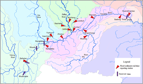
The China Three Gorges Corporation and the Hydrological Bureau of the Yangtze River Water Resources Commission have established a network of stations for real-time sediment monitoring in the upper reaches of the Yangtze River based on turbidity measurements, as shown in Figure 8. This has shortened the testing time for sediment concentration from 7 days to less than 1 h (B. Zhou et al., 2016). Furthermore, a real-time sediment forecasting model for the upper reaches of the Yangtze River, which is underpinned by a one-dimensional water-sediment mathematical model, and a GIS-based real-time sediment monitoring and forecasting system have been built. This enables real-time forecasting of sediment peak propagation process (Yang et al., 2020), with a forecasting accuracy of 85% for sediment concentration and a forecasting period of 7 days for sediment inflow. With the help of the platform of real-time monitoring, forecasting and dynamic regulation, sediment inflow and outflow, sediment transport process, and sedimentation changes in TGR under different regulation schemes can be predicted to support decision-making on real-time sediment regulation.
4.3 A dynamic sediment regulation mode featuring “regulating sediment for greater benefits”
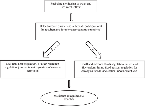
Building on the aforementioned research results of sediment transport pattern and real-time sediment forecasting and regulation technology, the approach of “storing clean water and discharging muddy flow” has been refined through the sediment management practices in TGR. A dynamic sediment regulation mode featuring “regulating sediment for greater benefits” has been developed. Based on the platform of real-time monitoring, sediment forecasting and dynamic regulation, regulatory measures are carried out at appropriate time including sediment peak control, siltation reduction, and joint operation of cascade reservoirs (Qiu & Li, 2021) in line with different water and sediment conditions to control sedimentation and improve siltation patterns. In addition, real-time measures are adopted such as small and medium floods regulation, water level fluctuations during flood season and earlier impoundment at the end of flood season, in a bid to maximize the comprehensive benefits of reservoirs, including flood control, power generation, navigation, ecosystem protection, water replenishment, and siltation reduction, as shown in Figure 9. In comparison, the dynamic sediment regulation mode enables the reservoir to operate more flexibly overcoming such limitations as the 145 m water level during flood season and the postflood (October 1) impoundment. It enables TGP to fully realize its comprehensive benefits while controlling sedimentation.
5 EFFECTS OF SEDIMENT REGULATION IN TGR
Since applied in 2012, sediment regulation technologies have created notable comprehensive benefits in TGR.
5.1 Optimized operation of reservoir
The new techniques for sediment regulation based on the pattern of sediment transport have broken through the 145 m limitation during flood season as requested in the operation mode of “storing clean water and discharging muddy flow.” The scheduling and dispatch of small and medium floods, raising reservoir level during flood season, and early impoundment at the end of flood season are hence made possible, and the reservoir's diverse functions can hence be fully harnessed. By virtue of such techniques, the reservoir can operate at a water level of 145–148 m during flood season, and the impoundment start time at the end of flood season has been moved from October 1 to September 10, and by the end of October over 90% of its storage capacity can be filled.
5.2 Improved pattern of sedimentation
Since applied in TGR, the new techniques for sediment regulation have helped reduce the deposition of sediment and improve the deposit location and pattern of sedimentation in the reservoir. The maximum sediment discharge ratio reached 45% during sediment peak regulation, 12% points higher year on year and 2.5 times the average since the 175 m impoundment. Since TGR was put into operation, no cumulative siltation occurred in river sections in the fluctuating backwater area. Sedimentation mainly deposits in the permanent backwater area, with 91% of the sediment in the dead storage. The loss of effective capacity is limited to 0.74%, much lower than predicted in the preliminary design, neutralizing the risk of raising flood control pressure and jeopardizing navigation due to sedimentation in the backwater area.
5.3 Augmented comprehensive benefits
Apart from reducing sedimentation, sediment regulation also contributes to flood control, power generation, navigation, and water resources utilization. By virtue of more flexible regulation, adjusting water levels during flood season enhances the reservoir's flood control capacity during regular floods and therefore reduces the pressure of flood control in middle and lower reaches of Yangtze River. Power generation has increased by 8660 GWh annually. Floodwater resources are utilized at the end of flood season for reservoir impoundment to effectively mitigate the impact of October impoundment on the downstream, which not only ensures the minimum navigable flow downstream, but also helps improve the downstream water ecology and environment. From 2017 to 2019, average outflow during low-water period increased by 1520, 1,720, and 2,170 m3/s, respectively.
6 CONCLUSIONS
- 1.
Patterns concerning the asynchronous propagation of flood and sediment peaks, sediment movement in backwater area during drawdown period, flood-time sediment deposition, and sediment flocculation have been clarified. This provides a theoretical basis for sediment peak regulation, siltation reduction regulation, and joint operation of cascade reservoirs.
- 2.
New technologies are proposed for above-mentioned sedimentation regulations with explanations on the timing, approach, and indicators for regulation. These technologies have helped reducing the deposit of sediment and improving the location and pattern of sedimentation.
- 3.
A network of real-time sediment monitoring stations in the upper reaches of Yangtze River has been established, and the platform of real-time monitoring, forecasting and dynamic regulation of water and sediment has been built. The operation mode of “storing clean water and discharging muddy flow” has upgraded to a dynamic sediment regulation mode of “regulating sediment for greater benefits.”
- 4.
Dynamic sediment regulation has helped break the constraints of sedimentation on reservoir operation, such as flood-season water level and postflood impoundment timing, and effectively improved TGP's comprehensive benefits in terms of flood control, power generation, navigation, ecosystem protection, water replenishment, and siltation reduction.
- 5.
In recent years, TGP has underwent a series of changes in water and sediment conditions. Sudden-onset sediment-laden floods in major tributaries have become the main source of sediment inflow to the reservoir. Meanwhile, more reservoirs have been constructed and put into operation on the upstream main-stem and tributaries. It is necessary to further optimize the joint operation of these cascade reservoirs and sediment discharge measures so as to provide scientific and technological support for TGP's safe and efficient operation.
ETHICS STATEMENT
None Declared.
Open Research
DATA AVAILABILITY STATEMENT
The data that support the findings of this study are available from the corresponding author upon reasonable request.


