Assessment of meander-bend migration of a major distributary of the Ganges River within Bangladesh
Abstract
The Arial Khan is an important distributary river of the Ganges River within Bangladesh. The river is meandering, and channel shifting and bend migration are common. This study investigates the bend-scale morphology of 37 characteristic bends of the river using Landsat imageries, river bathymetries, and hydrological data. The morphological changes of the river are correlated with the temporal shifting of its offtake, which in turn is linked to the dynamic behavior of the river in terms of sinuosity, bend geometry, and bend migration. Alterations in the offtake location, bed elevation, and in-front bar formation are found to control the flow to the river. The sinuosity varies from 1.62 to 1.95 and is linked to the shifting of its offtake. The lifetimes of the bends increase from upstream to downstream with an average lifetime of 24 years. The radii of the bends vary from upper to lower reaches with an average radius of 921 m. The upper reach is more migration prone, and its average migration rate (108 m/year) is more than twice the other two reaches. A higher migration rate of 70–80 m/year is found for the river during 1981–1999 compared to the rates of 45–50 m/year for the rest of the study periods (1972–2021). An envelope curve depicting the relation between the relative curvature of a bend and its migration rate for the river is also developed. The overall morphology from 1972 to 2021 indicates that a significant increase in sinuosity and a reduction in river width and aspect ratio have occurred. The migration rate has declined slightly and the frequency of bend cutoffs has reduced notably in recent years. Nonetheless, due to the high rates of migration, there exists potential future threat to riverbank erosion in some critical bends, and hence damages to land, property, structure, and project on the vulnerable banks.
1 INTRODUCTION
The dynamic behavior of any natural river system of a region is inherent to that region. When a single-thread channel of a river flows winding across its floodplain, a series of reversing curves form with varied sizes and shapes and leave a footprint of its course in an oscillatory path with a zigzag pattern known as a meandering river. The flow of water through the bend of a mender river produces centrifugal acceleration, resulting in a high-velocity flow field toward the outer bank (Pradhan et al., 2018; Rhoads, 2020). A secondary circulation also develops along the cross-section of the bend near the riverbed toward the inner bank and near the free surface toward the outer bank (Ferguson et al., 2003; Shaheed et al., 2021). Thus, in a typical meander river, the flow field is responsible for erosion at the outer or concave bank of a bend. This erodes sediment, transports, and afterward deposits near the succeeding inner or convex bank where the stream power is low enough to settle down the sediment. It is a continuous process where erosion and deposition take place simultaneously. This entire process governs the migration of bends of a meandering river. The excessive magnitude of migration near the river bends leads to the loss of land and property, and sometimes pose threats to infrastructure in the vicinity of the river. In some years and locations, these damages rise to a higher degree, but in other years and locations, they remain within a tolerance limit, which depends on the migration characteristics of the river. If the dynamic behavior of a river can be understood well, it is possible to keep the human-river negative interaction in an endurable stage. Hence, a bend-scale migration study of a river is particularly important in connection with riverbank stabilization, navigation, flood control, and the development of water resources projects.
The concept of bend migration, popularly known as the “bend theory,” was proposed by Ikeda et al. (1981). The theory describes that the bend instability results from the erosion at the outer bank by relatively high flow velocity and conversely the deposition at the inner bank by the deflected flow velocity. Based on this theory, in-depth studies on the meander river system have been conducted and different controlling factors have been identified to establish correlations with bend migration by researchers of different disciplines. However, all these correlations are not equally applicable to all meander rivers (Schumm & Thorne, 1989). The bend migration depends on many factors including discharge, water-surface slope, channel width and depth, bend geometry, and large floods (Heo et al., 2009; Hooke, 2006; Nicoll & Hickin, 2010). Moreover, the migration can be a discontinuous process and it might take place at individual bends for a specific time and rate (Chang, 1992).
Lagasse et al. (2004) suggested using the meander classification approach as it could provide basic insights about the bend instability from remote-sensing (RS) imagery and does not require excessive field data or observation. After the classification of the channel, bend-scale analysis of individual bends can be performed using different techniques, depending on the aim and outcome of a study. Some studies, for example, Bag et al. (2019) and Yousefi et al. (2021), used single bend, whereas others, for example, Mirzaee et al. (2018), Mason and Mohrig (2019), and Guo et al. (2021), dealt with many characteristics bends of a particular river reach to understand the changes in morphological characteristics and to explore the impact of sudden natural events or man-made interventions on a river. To establish empirical relationships among the parameters through bend studies, Hudson and Kesel (2000) used a single river with long-term data and Hickin and Nanson (1984), Nicoll and Hickin (2010), Sylvester et al. (2019), and Donovan et al. (2021) used multiple rivers within similar geomorphological settings. Other studies also suggested that rivers from a wide range of geomorphological settings should be incorporated to establish a general meander theorem (Hooke, 1987; Hudson & Kesel, 2000). Long-term historical data, images from remotely sensed and aerial photographs, topographic maps, and the geographic information system (GIS) were very common and frequently used in most of the studies.
The migration rates at 12 bends of the Sabine River were analyzed in Heo et al. (2009). It was found that the rates were maximum when the bend curvature ratio was 2.5, and when the value was below 1.6, the secondary flow was still active and scoured the outer bank. Hudson and Kesel (2000) studied the migration of 125 bends of the Mississippi River using long-term historical data and developed a relation between migration rate and bend curvature, where no hydrological entity was incorporated. In a study on two different characteristics of rivers with 290 bends, Guo et al. (2021) compared the patterns of morphological changes in terms of migration between two rivers. Studying 30 bends of the Trinity River in Texas, Mason and Mohrig (2019) identified a constant river width at a bend that was sustained by counterbalancing erosion and deposition during the migration process. Among many other studies on meandering rivers, lateral migration in flood season and thus reach- and time-scale changes of meander geometry were studied (Ghosh & Mukhopadhyay, 2021). A single bend was analyzed in Yousefi et al. (2021) to identify the change in the meander loop by a sudden extended flood.
Commensurate to the global studies, there were a few studies in Bangladesh on the morphological characteristics of a few rivers. Mamun (2008) reported the temporal changes in the offtake morphology of the Arial Khan River, but the reasons for such changes were not investigated. Hossain et al. (2007) identified the morphological changes of the river near the Arial Khan bridge. Biswas et al. (2018) analyzed the morphological variability and some related hydrological parameters of the upper Arial Khan River. Dewan et al. (2017) studied the meander parameters like sinuosity, erosion, and accretion, and the relation of these parameters with the hydrology of the Padma River. Halder and Mowla Chowdhury (2021) reported that the deep channel of the Padma River had moved in such a way that the flow path had turned from straight to meander during the 40-year period from 1979 to 2019. Spatiotemporal variation of morphology in terms of point bar, river width, bend migration rate, and river sinuosity of the Gorai-Madhumati River during the pre- and post-Farakka eras from 1972 to 2018 were studied in Gazi et al. (2020) using RS and GIS techniques. The changes in the bend geometry of the Dhaleshwari River were analyzed in Banda (2018). Using GIS and prediction model, the future prediction of morphological changes in select reaches of the Teesta River was attempted in Akhter et al. (2019).
In the river-morphology studies in Bangladesh (Akter et al., 2013; Ashrafuzzaman, 1992; Biswas et al., 2018; Hossain et al., 2007; Mamun, 2008; Winkley et al., 1994), the meander-bend characterization and migration did not receive due attention. The controlling factors involved in the bend-migration process were not also investigated thoroughly and systematically. Moreover, the hydromorphology of a distributary river is dependent not only on the discharge of the parent river but also on its own flow features controlled by the morphology of its offtake. It is to be noted that, in Bangladesh, the meandering rivers generally offtake from larger rivers and flow through alluvial floodplains of similar characteristics. The hydromorphological processes at these larger rivers have great impacts on the hydromorphology of the distributary rivers. However, the role of an offtake in influencing the hydromorphology of the distributary river was not investigated thoroughly in previous studies. Though the improvement in the resolution of satellite images and the availability of different image-possessing tools have facilitated the hydro-morphological analysis on multiple time scales (Constantine et al., 2014; Hickin & Nanson, 1984; Jarriel et al., 2021; Morais et al., 2016), yet the multiple bend-scale analysis in an effective way is still a challenge for a very active meander river like the Arial Khan as the bends are neither smooth in shape, nor homogeneous in terms of magnitude and direction of migrations. Such a river exhibits to a great extent both spatial and temporal variability in meander intensity. This study investigates the offtake morphology and meander-bend migration of the Arial Khan River. It considers the change in hydrological parameters and offtake shifting as the controlling factors for spatiotemporal change in the morphology. The study focuses both the reach- and bend-scale morphology of the Arial Khan River for a period of 50 years from 1972 to 2021. The study would help in better planning and designing of structural interventions on and around the Arial Khan and other rivers in the region.
2 MATERIALS AND METHODS
2.1 Study area
The Arial Khan River is a part of the Ganges River system and one of the significant meandering rivers of Bangladesh. It flows south-eastward after taking off from the right bank of the Ganges River at Chowdhuri Char of the Faridpur district. At 54 km upstream of the offtake point, the Ganges River, locally known as the Padma, receives the combined flow of the mighty Ganges and Brahmaputra rivers at Aricha-Goalundo. As a distributary river, the Arial Khan receives partial flows of the Ganges (Padma) and carries to the Bay of Bengal through the Tentulia Channel. It also receives the water from a few tributaries, such as the Palong, Beel Padma, and Moinakata, and delivers through a few distributary rivers and khals, such as the Kumar, Lower Kumar, Torki, and Palordi. Of the total course of the river, about 90% is within the Madaripur district and the rest is in the Barishal district. Figure 1 shows the location and planform of the river in the year 2021.

The average length of the river is about 108 km, though yearly stretching and shortening of the length are found at regular intervals, depending on the fluvial processes within the Arial Khan and the upstream Ganges river system. Before the massive earthquake in 1762, the present Arial Khan course was the main course of the Ganges River and directly transmitted the Ganges and Brahmaputra flows to the Bay of Bengal (Sarker, 2008). Later on, the Ganges River incised the floodplain near Chowdhury Char to form the present course. Since then, the Arial Khan has been flowing as a right bank distributary of the Ganges River. Lateral shifting of these two rivers occurs repeatedly within the adjacent floodplain, some of which are still visible as meander scars.
About 2%–6% of the flows of the Ganges is diverted into the Arial Khan with a significant annual variation. The annual discharge and sediment of this river are about 30 billion m3 and 25 million tons, respectively (Sarker et al., 2013). The maximum, minimum, and average annual discharges of the river are 3067, 56, and 795 m3/s, respectively. The highest daily discharge has so far been 5810 m3/s during the 1991 flood. During the monsoon, high velocity washes away loose sediment from the bank and bed, and causes erosion along the river. But during the dry season, sedimentation forms narrow and shallow channels due to very low flow velocity. As a result, annual as well as monthly morphological variation is very common for the Arial Khan River, which causes permanent and temporary changes in cross-section, slope, thalweg, and so on.
Considering the distinct morphological characteristics found from a preliminary river planform study, the river was divided into three reaches: upper reach (R1), middle reach (R2), and lower reach (R3) (Figure 1). The reaches R1, R2, and R3 have average lengths of about 38, 40, and 30 km, respectively. The reach R2 starts from downstream of the offtake of the Kumar River and the reach R3 starts from about 10 km downstream of the confluence with the Palong River. The reach R1 has a comparatively wide active floodplain and valley, with loosely compacted soil and thin and sparse vegetation. The reach R2 is avulsion prone, having two distributary rivers and a continuous 2.1 km long protected bank. The reach R3 has consistent and unidirectional erosion in almost all its bends. The current bed slope of the river is about 4.2 cm/km.
2.2 Remotely sensed time-series data
The increasing availability of satellite images ensures the possibility to build up an extensive and reliable data set from which river planform configurations and channel width distributions can be extracted. In this study, Landsat satellite images available from the US Geological Survey (USGS) were used, which have the advantages of being open source, geo-referenced, and available since 1972. The spatial and temporal variations in the planform were preliminarily analyzed. The years of time series were selected as the years when the Ganges River had reached its final stage of meandering or straight channel formation, after that stage the channel started to reverse back. The selected years were 1972, 1980, 1999, 2007, and 2021. In addition, the years of 1988 and 2017 were included as interim years.
Landsat images for the winter season (December to February) were chosen as the sky remains cloud-free, and the river maintains a consistent hydrological condition during this season for most years. The satellite images of the Multispectral Scanner (MSS), Thematic Mapper (TM), and Operational Land Imager (OLI) of different bands were collected from the USGS free online portal called USGS Earth Explorer. The information on the images is given in Table 1.
| Satellite sensor-bands | Path/row | Date (day/month/year) | Collection-level | Resolution (m) |
|---|---|---|---|---|
| Landsat 1 MSS-B4567 | 147/44 | 28/12/1972 | C2-L1 | 60 |
| Landsat 3 MSS-B4567 | 147/44 | 02/02/1980 | C2-L1 | 60 |
| Landsat 5 TM-B1234567 | 137/44 | 02/01/1988 | C2-L1 | 30 |
| Landsat 5 TM-B1234567 | 137/44 | 01/02/1999 | C2-L1 | 30 |
| Landsat 5 TM-B1234567 | 137/44 | 23/02/2007 | C2-L1 | 30 |
| Landsat 8 OLI-B123456791011 | 137/44 | 17/01/2017 | C2-L1 | 30 |
| Landsat 8 OLI-B123456791011 | 137/44 | 13/02/2021 | C2-L1 | 30 |
2.3 Analysis of the offtake hydromorphology
Annual variation in the hydromorphology of the Arial Khan offtake plays a vital role in its fluvial processes (Mamun, 2008). The hydromorphology of the offtake was studied based on the satellite image and secondary data (discharge, water level, and bathymetry) collected from the Bangladesh Water Development Board (BWDB), Dhaka. The shifting of the offtake location was identified through bankline delineation using ArcGIS starting from 1972 and then successively for 1980, 1988, 1999, 2007, 2017, and 2021. The discharge ( ) and water level (
 ) were collected and analyzed for the gage station of the Arial Khan Offtake (ID: SW4A). The bathymetric measurements were available at different sections of the river at certain intervals from BWDB. The bathymetric data at the offtake were available for 1978 to 2019. The annual changes in bed level in terms of thalweg elevation were calculated and the variations in bed levels during different periods were estimated.
 and
and  for the Arial Khan River for the monsoon season. The general equation of the rating curve was as follows:
 ()
() is the estimated discharge in m3/s,
  is the water level in m above Public Works Datum (PWD) and
  is the value of
  corresponding to
  .
.  and
and  are the rating curve constants, which were estimated from the following equations:
 ()
() ()
() ()
() ()
() and
and  are plotted in Figure 2, from which “
 ” is calculated as below (Subramanya, 2008):
 ()
()
Using the daily  and the developed rating curve, the daily
  was estimated. Finally, the annual maximum, average, and minimum discharges were estimated from the daily
  values.
2.4 River planform analysis
 ()
()Though the modified NDWI performs better than any other indices for the extraction of water bodies (Gautam et al., 2015), it is not applicable for the images of Landsat 1-5 MSS. Moreover, for the nonurban river course extraction, NDWI provides good results (Roy Mukherjee & Samuel, 2016).
 ) of the river was then calculated as:
 ()
()The river width ( ) was measured from the satellite images at the select bends as well as at the outside of the bends. At an individual bend,
  was measured at two crossings or inflection points and at the apex of the bend for each time period. But at the outside of the bends,
  was measured at a distance of 1.5 km for each time period and the average values were calculated. The average water depth, slope (
 ), and thalweg elevation of the river were determined from the bathymetric data of BWDB.
2.5 Selection of meander bends and estimation of bend geometry parameters
The identification and quantification of different bend parameters were done using the AutoCAD software as it is the most convenient option for drawing elements and taking measurements of several geometric parameters precisely and hence allowing for a straightforward quantification of migration by both linear and angular measurements. The characteristic bends were selected first, and then the parameters of bend geometries, such as the radius of curvature ( ), meander length/wavelength (
 ), meander width (
 ), migration, and migration rate (
 ) (Figure 3), were obtained.

An active meander river demonstrates its meander behavior by continuously evolving numerous bends of different shapes and lifetimes throughout its length. The Arial Khan is so dynamic that no single bend stays at the same position for more than 2–5 years (Akter et al., 2013). Thus, the characteristic bend selection was a challenging task for this river, particularly from the upper and middle reaches. In this study, the bends were selected with an arc angle of mostly around 60° along the channel centerline (Brice, 1974). Some bends with a lower arc angle were also selected when their life spans had exceeded a minimum of two time periods, which were approximately 14 years. Generally, the bend curvature is an arc of a circle, drawn along the outer bank which passes through the bend apex and the two crossings on the upstream and downstream sides of the bend, and is represented by  . A total of 37 bends were selected in the study and given individual bend IDs (Figure 4). Some bends had regenerated in the same location after bend cutoff, which was identified by a suffix after bend ID, for example, a and b.

The crossing was identified as either the location of the lowest width or the location where the river bankline changes its direction of alignment, near the comparatively straight portion of two consecutive bends. The apex point was selected as the maximum deflection point of the outer bank of a bend, which was nearly the midpoint for most of the bends. Curvature was drawn in such a way that it touched the apex or apex-like point and passed through at least one crossing or the nearest points of two crossings.
 and
and  should be derived from an ideal meander belt, like an “S” shaped sinuous curve, which is very uncommon in a natural meander river as the explicit sinuous shape neither develops nor persists for a long time. Thus, in most of the studies, the meander belt parameters (e.g., meander amplitude,
  and
and  ) are calculated as half of the parameters measured from a single bend, and then simply doubled these values. In this study, at least one meander belt, which was visible and persisted for more than two time periods, was identified from each of the three reaches. All together 10 representative meander belts were selected.
  was measured as the distance between the two apex points on the same side of the valley for an elongated loop, or two crossing points of the same phase.
  was measured as the linear distance between channel centerlines at two apex points on opposite sides of the valley. When
  and
and  were taken from a single bend, they were considered as half and were doubled to get the full values.
2.6 Analysis of bend migration
The mode of migration was found in three steps: (1) identification of the shape of a bend in the initial year of 1972 or the shape of a newly generated bend in a different year, (2) identification of the mode of migration followed by an individual bend during a time period, and (3) identification of the ultimate fate of the bend from its migration mode in the latest years. The following modes of migration were considered: cutoff (CO), lateral migration (LM), downstream migration (DM), upstream migration (UM), straight, stable, and avulsion. The shape of a bend was considered as simple symmetrical (SS), simple asymmetrical (SA), elongated symmetrical loop (ESL), asymmetrical elongated loop (AEL), symmetrical compound loop (SCL), and asymmetrical compound loop (ACL) (Rosgen, 1994).
 . The best-fitting circle was used to determine the
  of a bend as below (Finotello et al., 2018; Lagasse et al., 2004):
 ()
() ()
() ()
() is the quantity of migration (m) for bend translation, which is the linear migration of the centroid of the best-fitted circles from an initial year (Y1) to a final year (Y2), and
  is the quantity of migration (m) due to an expansion or a contraction of the bend, which is the change of radius (
 ) of the circle between Y1 and Y2 years.
  and
and  were obtained from linear distance measurements in AutoCAD.
3 RESULTS
3.1 Hydromorphology of the Arial Khan offtake
The Ganges (Padma) River planform near the Arial Khan offtake exhibits a periodic change in its channel formation alternating between straight single-thread channel and meandering, braided-anabranch or double-threaded with single or multiple mid-channel bars. Historically, the Ganges River's left bank at this location remained almost in position though temporarily some sand bars were accumulated through the process of accretion and washed away along with the mid-channel bars through the process of erosion (Nippon Koei, 2005). Alternately, when the erosion process dominated along the right bank of the river, it changed its course from straight to meander or braided with a multithread channel and sand bars accumulated in the mid-channel and along the left bank (Sarker, 2008). The bar push phenomenon accelerated the erosion at the outer bank of the meander (right bank), which resulted in an expansion of the bend as well as the river width. Although the bank erosion of the Padma River and the offtake shifting of the Arial Khan are generally thought to be the results of annual fluctuations in water flow (Dewan et al., 2017), sediment dynamics (Zheng et al., 2021), and both water and sediment dynamics (Nawfee et al., 2018; Nippon Koei, 2005) of the Padma River, the processes are actually very complex and yet to be thoroughly studied. However, the alternating bar formation near the entrance to the Arial Khan alters the discharge and sediment load into the distributary (Winkley et al., 1994). Figure 5 depicts the distinct phases of shifting of the Arial Khan offtake, and the channel and mid-channel bar formation in the Padma River at different time intervals.

The meander channel with mid-channel bars in the Padma was found during the downward (south or southwest) shifting of the offtake in 1972, 1999, 2017, and 2021, and the straight channel was found during the upward (north or northeast) shifting of the offtake in 1980 and 2007. The erosion process was sustained on an average for 19 consecutive years, and the accretion-deposition process took place in a relatively shorter period of 8 years. The offtake point oscillated across the right bank of the Padma River. A significant width variation of the Padma River at the offtake section was also found (Table 2). Thus, the accretion and erosion processes occurred along the right bank during the study period from 1972 to 2021.
| Year | Padma River width (km) | Offtake shifting (km) | Bar size (km2) | Padma River planform near the offtake |
|---|---|---|---|---|
| 1972 | 11.25 | - | 83 | Meander—double threads, separated by a large bar |
| 1980 | 7.30 | 5.07 | >1 | Straight—single thread, small mid-channel bar |
| 1999 | 11.00 | −4.31a | 140 | Meander—double threads, separated by a large bar |
| 2007 | 5.45 | 6.72 | - | Straight |
| 2021 | 8.25 | −5.68a | 79 | Meander—double threads, separated by a large bar |
- a Negative sign indicates downward shifting of the offtake.
The offtake hydromorphology comprised three interdependent elements: (1) the existence of a mid-channel bar in front of the offtake, (2) the planform of the Padma River near the offtake, and (3) the direction of flow of the Padma River near the offtake. During meander channel formation, the offtake was shifted along the right bank of the Padma River and situated nearly at the apex point of the bend. The right bank erosion and the mid-channel bar accumulation occurred simultaneously and guided the direction of flow. The continuous growth of several small bars sometimes formed a single extended bar, which divided the flow into two threads along the left and right banks. But when the channel of the Padma was in a straight form, the offtake was shifted and the flow moved more towards the left bank.
The bathymetry analysis revealed that the lowest bed level or thalweg of the offtake was related to the offtake shifting as well as the channel form of the Padma River. During the periods of meander channel formation in 1981–1999 and 2008–2019, the thalweg had deepened and reached its lowest level. The opposite scenario persisted during the periods of straight channel formation. The thalweg at the offtake varied from 2.59 m PWD during straight channel formation to −1.96 m PWD during meander channel formation.
 ()
()3.2 River planform and channel geometry
The planform analysis of the Arial Khan River revealed that the upper reach R1 is very dynamic in terms of channel shifting and bend migration. The morphological parameters have changed during all the time periods in the R1 reach. Bend generation and evolution have occurred at a faster pace in this reach. The middle reach R2 is avulsion prone as channel avulsion has taken place twice in this reach. However, the reach R2 has bends prone less to migration. The characteristics of the R3 reach are quite different from that of the R1 reach. The R3 reach is stable in terms of bend creation, dissipation, and direction of migration. No bend has completely disappeared, though small chute cutoffs near the apex have made minor changes in the shape of two bends. The spatial variability in planform of the river can largely be attributed to the nonuniform distribution of the bank materials and changes in flow conditions along the course of the river due to the several entrances of tributaries and exits of distributaries (Winkley et al., 1994). The change in length along with some other parameters of the Arial Khan River for different time periods is shown in Table 3. Table 4 summarizes the parameters of river planform and bend-scale morphology for the three reaches.
| Parameters | 1972 | 1980 | 1988 | 1999 | 2007 | 2017 | 2021 |
|---|---|---|---|---|---|---|---|
| Length (km) | 109 | 101 | 106 | 105 | 109 | 111 | 115 |
| Sinuosity | 1.87 | 1.62 | 1.69 | 1.79 | 1.72 | 1.88 | 1.95 |
| Width (m) | 324 | 294 | 349 | 306 | 264 | 210 | 222 |
| Bend cutoff (nos.) | - | 3 | 1 | 1 | 1 | - | - |
| Migration rate (m/year) | - | 38 (1972–1980) | 82 (1981–1988) | 67 (1989–1999) | 78 (2000–2007) | 50 (2008–2017) | 46 (2018–2021) |
| Parameters | Upper reach | Middle reach | Lower reach |
|---|---|---|---|
| Length (km) | 38 | 40 | 30 |
| Sinuosity | 1.60 | 1.54 | 2.11 |
| Width (m) | 237 | 277 | 320 |
| Depth (m) | 2.64 | 3.26 | 5.46 |
| Aspect ratio | 90 | 86 | 66 |
| Permanent intervention nos. | 2 | 1 | 1 |
| Lifetime of bend (years) | 18 | 25 | 32 |
| Bend cutoff nos. | 4 | 1 | 1 |
| Radius of curvature (m) | 775 | 1127 | 883 |
| Relative curvature | 3.5 | 4.8 | 3.1 |
| Migration rate (m/year) | 108 | 42 | 46 |
| Migration mode | Downstream | Lateral | Lateral |
The river acquires an extra length of 5–7 km during periods of upward shifting of the offtake, but the overall length shortens significantly. During these periods, the average length of the river remains to be about 104 km. On the other hand, during the periods of downward shifting of the offtake, the river loses a 4–6 km course from its uppermost portion, though its total length increases by several kilometers. During these periods, the average length of the river becomes about 109 km. So far, the Arial Khan River has exhibited the highest length of 114 km in 2021 and the lowest length of 100 km in 1980.
The variations in the average width of the river and its different reaches with time indicate that, after 1972, the maximum width was generated in 1988, and thereafter the widths of all the reaches had decreased till 2017. In recent years, the width has started to increase again. In general, the width of the river increases in the downstream direction. The average widths are found to be about 237, 277, and 320 m for the reaches R1, R2, and R3, respectively, and 281 m for the entire river. Like width, the depth of the river increases from the upstream to the downstream. In conformity, the thalweg elevation of the river decreases in the downstream direction.
Like length, the SI of the river has changed with the shifting of its offtake. The SI values were higher when the offtake shifted downward and vice versa. The coefficient of correlation (R) between these two variables was 0.81. The highest SI of 1.96 was found in 2021 and the lowest SI of 1.62 in 1980. Of the three reaches, the R1 reach has exhibited a great variation in the SI values with time (~1.3–~2.5). The R2 reach has maintained a constant SI value of around 1.5. The R3 reach has shown an increasing trend in SI from 1.5 to 2.5. According to channel classification, a channel is called a meander channel when the SI value is between 1.3 and 2.5 (Rhoads, 2020). Thus, the Arial Khan River and its individual reaches are pure meander.
An important parameter in river morphology is the channel aspect ratio, which is the ratio of width to depth of a river. The aspect ratio indicates whether a channel would migrate or not, and which reach would migrate. In general, a channel with a larger aspect ratio migrates more than that of a smaller ratio. In a narrow channel with aspect ratio less than 10–20, the thalweg passes through almost the middle of the channel, and a flow regime concentrated in mid-channel develops. As a result, there is less chance to form the bar units in the river, and the banks stay away from the flow attacks (Seminara & Tubino, 1989). The Arial Khan River, however, has a larger aspect ratio (>50) and is susceptible to bar formation and hence to bank erosion and migration. The average aspect ratio is high in the upper reach R1 and the ratio decreases in the downstream direction of the river. The average migration rate is also high in the R1 reach. The migration rates in the R2 and R3 reaches are low and comparable.
3.3 Bend geometry
The bends of the Arial Khan River are of varying sizes and shapes. The course adjustment and bend size and shape changes are quite common in this river. During the period from 1972 to 2021, there were 37 bends in total. Some of these bends changed their shapes through neck cutoff, chute cutoff, or bend disappearance. The generation, development, and period of existence of these bends are different. The different modes of migration of the bends of the river during different time periods are shown in Figure 6.

Initially, in 1972, the total number of bends was 17, which increased to 25 in 1999 and then decreased to 23 in 2021. Among the three reaches, R1 is the most dynamic, and the bend generation, bend cutoff, and migration—all are very common in this reach. The matured bends have either migrated in the form of downstream migration or gone through the bend cutoff. A considerable number of bend cutoffs have taken place in this reach. Some bends of the reach were transformed into straight channels, especially in the downstream part. Such straightening can be due to the effect of the river training works at the Arial Khan Bridge. As the flow direction in the reach has changed frequently within a very short period of time, the rates of erosion and deposition have been high, the sediment has remained unconsolidated, and the valley has been wide in the reach. The R2 reach can be characterized as avulsion prone as channel avulsion has occurred twice in this reach. This part of the river is occupied by several stable bends and the overall channel stability of this reach is higher than the rest two reaches. The mid-portion of this reach has long and sustained bank protection for Madaripur town since 1987. This river training work could have imparted to the bank stability and thus influenced its meandering pattern to some extent. The bend migration in the lower reach R3 is dominated mostly by lateral migration, and the erosion is unidirectional. A small-scale, chute type of cutoff has occurred at two bends, but this has not made any significant alteration in the overall bend shapes.
Among the 37 bends, the number of stable bends was 3, lateral migration occurred at 14 bends, downstream migration at 4 bends, upstream migration at 2 bends, the number of bend cutoffs was 6, the number of bend avulsions was 4, and the number of bends that transformed into straight channels was 4. From the age of each bend, it was found that only seven bends could sustain throughout the full study period, situated mostly in R3 and R2. The average age of the bends was low (18 years) in R1, intermediate (25 years) in R2, and high (32 years) in R3. In the R1 reach, bend disappearance by channel straightening has happened in a few occasions and none of the bends has survived for the whole study period of 49 years. In R2, two bends (16% of the bends) have survived for the whole study period, and in R3, five bends (45%) have sustained for the whole study period.
The average  of the 37 bends is found to be 921 m. The average
  is 775, 1127, and 883 m in the reaches R1, R2, and R3, respectively. Thus, the values are relatively higher in R2 than in R1 and R3. For the six significant cutoffs that have occurred during the study period, the average time per cutoff is 8 years or 0.055 cutoffs have occurred per kilometer of the river. The
  of the cutoff bends and the years of the cutoffs are given in Table 5. The average
  of the cutoff bends is found to be 501 m with a range of 218–817 m.
| Bend ID | Nature of cutoff | Year of cutoff | RC (m) | ||||
|---|---|---|---|---|---|---|---|
| 1972 | 1980 | 1988 | 1999 | 2007 | |||
| B1 | Chute | 1988 | 426 | 494 | - | - | - |
| B5 | Neck | 1978 | 218 | - | - | - | - |
| B5a | Neck | 2004 | - | 407 | 786 | 975 | 817 |
| B11 | Chute | 1976 | 432 | - | - | - | - |
| B19 | Neck | 1999 | 547 | 491 | 474 | 453 | - |
| B23 | Chute | 2004 | 881 | 848 | 857 | 521 | - |
3.4 Bend migration
The bends of the R1 reach have a higher migration rate ( ) than that of the R2 and R3 reaches. The migration rates are 108, 42, and 46 m/year for the R1, R2, and R3 reaches, respectively. Thus, the
  in R1 is more than twice the
  in R2 and R3. Also, the
  in the R2 and R3 reaches are very close as the reaches are wider and deeper, and the floodplains have more compacted soils compared to the R1 reach. Most of the bends in R2 have
  below 40 m/year. The bend B11a has experienced the highest
  of 203 m/year, which is situated near the end of the R1 reach. The lowest
  of 12 m/year is found at the bend B16a of R2, the upstream limb of the banks at this bend being artificially protected.
The helical motion is responsible for bend creation and migration (Chang, 1992). The strength of this motion depends on the sharpness of the bend, defined by the relative curvature ( ). The sharper the bend, the stronger the motion. For the sharper bend at a certain value of
  ,
,  becomes saturated and below which the flow separation occurs at the outer bank. Thus, the outer bank remains protected by the flow with comparatively weaker stress. Again,
  reaches the highest value, above which
  declines again. Thus, a higher
  occurs within a certain range of
  , which varies with rivers depending on the characteristics of the river system of a region. Hickin and Nanson, (1975, 1984) and Nanson and Hickin (1986) studied around 125 bends of 19 different river reaches in Canada and found that the maximum
  occurs when 2 <
  < 3. The average value of
  of different bends for different time periods along the entire length of the Arial Khan River is presented in Figure 7. From the calculated
  values, an envelope curve is also developed.

 ) and relative curvature (
 ) at different bends of the Arial Khan River
The envelope curve, in fact, provides a range of  values at which bend migration is maximum for a specific river. It indicates that for the
  values of 1.5–3.5, most of the bends of the Arial Khan River migrate and
  is also high in this range with a peak at about 3.0. Beyond this range, that is.,
  < 1.5 and
  > 3.5,
  is low for most of the bends. Thus, the moderate curvature bends of the Arial Khan River are highly susceptible to erosion, and the large, as well as the sharp bends, are less erosion prone. It is also seen from Figure 7 that the bends developed within the time period of 1972–1999 were more likely to maintain the
  value within the range of 1.5–3.5 than the bends developed after 1999. The bends of recent years exhibit high scatters in
  values, and the average value is far beyond the range of maximum migration. From the analyses on individual reaches, it is found that the bends of the R1 and R3 reaches have average
  values within the range of 1.5–3.5. But the bends of the R2 reach have an average
  value of 4.8, which is beyond the estimated range.
4 DISCUSSION
The Arial Khan River acts as an important linkage between the Ganges River and the vast south-central region of Bangladesh. It plays a key role in maintaining the harmony of the natural environment of the region through an interconnected river network, particularly in downstream. On the other hand, this river brings misfortune to the locality when hundreds of hectares of arable lands and properties along the riverbanks become extinct from its erosion and migration. The migration of this alluvial meander river is mainly bend-oriented, which is influenced by a number of factors including the hydromorphology of the river, the geometry of its bends, and the characteristics of its floodplain and valley. In addition, the morphology of its offtake plays a vital role in defining the river characteristics.
The Ganges River planform near the Arial Khan offtake influences the flow regime of the Ganges, and the Arial Khan offtake morphology influences the amount of diversion of the Ganges flow into the Arial Khan. The Arial Khan receives 2%–6% of the monsoon flows of the Ganges. There is a relationship between the offtake shifting and the change in course length of the Arial Khan. The total length increases during the meander formation in the Ganges River or the downward shifting of the offtake. The length decreases during the straight channel formation in the Ganges or upward shifting of the offtake. This is in contrary to the general expectation that a downward shifting would reduce and an upward shifting would increase the river length. The changes in the meandering pattern with shifts in the offtake position are responsible for this length variation. This variation in river length is mostly resonated in the R1 reach. The lengths of the R2 and R3 reaches have increased successively during most of the time periods, indicating that offtake shifting has no impact on the changes of their lengths. Thus, the offtake shifting works as a control in influencing the length of the R1 reach and hence the length of the entire river. The bend migration and hence the migration rate have also some linkages to this offtake shifting—a higher migration rate occurs during the upward shifting of the offtake compared to the downward shifting.
It is suggested in some literatures (Rhoads, 2020; Shen et al., 1979) that the total discharge, that is, the absolute quantity of water and sediment, is less important to giving channel shape and sinuosity than the type and percent of sediment load. There is a large periodic variability in the total suspended sediment concentration of the Ganges River (Zheng et al., 2021). This periodic variability in sediment concentration of the Ganges River and hence the Arial Khan itself could have potential linkage with the periodic offtake shifting, and the river shape and sinuosity changes. Again, the Arial Khan has reached higher SI and relatively lower and constant migration rate in recent years, which indicates that the river might have attained its morphological adjustments, especially in the middle and lower reaches. The present planforms of R2 and R3 might sustain for a longer period unless there is a large magnitude flood or a huge variability in discharge in the river in the near future. When the SI becomes sufficiently large, the migration rate reduces as well as the planform geometry changes less or remains unchanged (Duan & Julien, 2010).
The Arial Khan follows the pattern of a general river in terms of width and depth. Both its width and depth increase in the downstream direction. The R1 reach faces a higher variability in discharge and hence it is the shallowest and narrowest among the three reaches (Rosgen, 1994). Also, the downstream increase in width and depth could indicate an adjustment of the river to the increasing discharge and sediment supply in the R2 and R3 reaches (Rhoads, 2020). Again, the maturity of the bends is higher, and the migration rate is lower in the R2 and R3 reaches. The bend-scale parameters of the R2 and R3 reaches are found to be nearly similar. The effect of major floods on bend cutoff is found to be insignificant as only one cutoff was found to have occurred due to the major flood event of 1998. However, the sinuosity of the river has changed to some extent immediately after the flood events in 1988, 1998, and 2007.
Analysis of available measured monsoon data reveals that there are strong correlations between the power function of discharge and the width, depth, and velocity of the river (e.g.,  ). The coefficients of determination of the functions were found to be 0.81, 0.93, and 0.76 for the width, depth, and velocity, respectively. The corresponding exponents of discharge were 0.24, 0.36, and 0.40, similar to the values of 0.26, 0.40, and 0.34 reported in Leopold and Maddock (1953). The resulting coefficients of the power functions were 57.2, 0.37, and 0.05. Both the sum of the exponents and the product of the coefficients are unity.
The meander length and width of a river vary with its discharge (Leopold & Wolman, 1957). For the Arial Khan, the relation between  and
and  is found to be
  , which is similar to
  reported in Leopold and Wolman (1957). Also, the relation between
  and
and  is found to be
  , which is similar to
 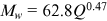 reported in Leopold et al. (1964). The coefficient of determination was 0.92 in the former case (
 ) and 0.76 in the latter (
 ). Some relationships were also found between
  and
and  , with a variation of the relationship with time. The bend migration of the river was found to be responsive to the width change more in the past than that in the present. The ratio of
  to
to  for the river was around 11–16 for the period 1972–1999 and 3–8 after 1999. Leopold and Wolman (1957) established the ratio to be 10–14. Thus, the past ratio is similar to the ratio given in Leopold and Wolman. It is to be noted that the discharge of the Arial Khan has decreased gradually since 2000, except for the moderate flood years of 2007 and 2018.
Though there is a similarity in shape, the  curve differs in value from an ideal range reported in different literatures (Bagnold, 1960; Hickin & Nanson, 1984). This difference might be due to the heterogeneous floodplains of the river and the change in discharge along its course. The valley in the upper and middle reaches is comparatively extended and covered with loose riverine sediment than that of the lower reach. The geological features of meander scars and clay plugs are quite common in the upper reach floodplain, which might interplay in the river adjustment through bend migration.
The human interventions for bank protection might have constrained the free movement of the riverbanks across the river valley. These could be particularly relevant for the downstream part of the R1 reach and the middle portion of the R2 reach. The higher stability of the R2 reach and its bends could partly be due to the bank protection works. Several tributaries and distributaries of the Arial Khan could have put a significant influence on bend migration as they contribute or intake some quantities of water and sediment. The bend B3 can outflank the Hazi Shariatullah Bridge on the river in the near future and pose a threat to the bank protection works of the Dhaka–Mawa–Bhanga national highway. The curvature of the bend B17 can increase and cause erosion to a vast area at Baherchar Katla. The bend B27 in the lower reach has already experienced a small-scale chute cutoff. There is also further possibility of channel avulsion at this bend in the near future, by which a 10 km reach of the river could be abandoned.
5 CONCLUSIONS
As a connecting river, the Arial Khan is especially important for the surrounding floodplains and other tributary and distributary rivers, khals, and canals. This study analyzes the morphology and bend migration of the river and identifies some important control parameters. The overall shifting of this alluvial meander river has been in response to the offtake hydromorphology and bend migration. The offtake of the river from the Ganges works as a strong control in shaping the hydromorphology of the Arial Khan. The offtake position has changed periodically, which has resulted in changes of river length and sinuosity.
The upper reach has a relatively wide valley with loosely compacted overbank soil, extended point bars along the banks, thin and scattered floodplain vegetation, and several tributaries and distributaries. The lower reach is in a more natural environment having dense vegetation, compacted soil, and comparatively fewer and insignificant confluences. The bends of the upper reach are found to be dynamic and random in morphology, whereas those of the middle and lower reaches are found to be static and consistent. The bend migration rates were found to be 108, 42, and 46 m/year in the upper, middle, and lower reaches, respectively. In the middle reach, some bank protection works have been installed. As a result, some bends of this reach have neither migrated naturally nor subjected to continuous erosion or deposition for a long period due to channel avulsion.
The Arial Khan River has significant temporal variability in discharge as well as in sinuosity, length, width, depth, and other bend parameters. The average width and depth of the river reaches are found in the order of lower reach > middle reach > upper reach. The temporal analysis shows that the width, depth, aspect ratio, and bend migration have falling trends with time, probably due to a decreasing discharge and installation of bank protection works. In the recent years, most of the bends of the river are changing their shapes by going through either an expansion or a contraction process. Also, the river has not faced any bend cutoff in the last 17 years, though it has an increasing trend in the sinuosity. These shifting and migration characteristics of the bends should be duly considered while installing a hydraulic intervention on the river, particularly in the upper reach.
ACKNOWLEDGMENT
We thank the reviewer and the associate editor for their comments and suggestions which helped improve the quality of this paper. This study was funded by the Bangladesh University of Engineering and Technology through the Committee for Advance Studies and Research.
ETHICS STATEMENT
None declared.
Open Research
DATA AVAILABILITY STATEMENT
The data that support the findings of this study can be made available upon request to the corresponding author.