“Skylights” increase exposure levels and reduce the maximum depth of nature reserves
“天窗”增加自然保护区的暴露水平,降低最大深度
Editor-in-Chief & Handling Editor: Ahimsa Campos-Arceiz
Abstract
enSpatial contradictions between nature conservation and social development are prominent in the integration and optimization of nature reserves (NRs) in China. Due to restrictions from the farmland “red line” policy and territorial spatial planning, scattered urban areas and farmland distributed within NRs form many “skylights”. Perforating NRs alters their shape and continuity and may have negative effects on long-term conservation. Through remote sensing data, we identified urban areas and farmland “skylights” in NRs in Guangdong Province, China. This study evaluated four scenarios: maintaining both urban areas and farmland (current state), maintaining farmland while removing urban areas, maintaining urban areas while removing farmland, and removing both urban areas and farmland. Two indicators, the exposure level and the maximum depth of NRs, were used to preliminarily assess the impacts of “skylights”. We found that urban “skylights” accounted for a relatively low proportion (5.81%) of total “skylights” and farmland “skylights” accounted for 94.19%. The current exposure level of NRs in Guangdong Province was very high, and approximately 82.83% of the NR areas were within 1 km of an unprotected matrix. If “skylights” were removed without exception, the 1 km exposure level would decrease to 61.37%, and the maximum depth would significantly increase. We recommend further assessment of the influence of “skylights” on the conservation effect of NRs and suggest first removing small “skylights” to reduce their negative impact.
摘要
zh在中国自然保护地整合与优化进程中,自然保护与社会发展的空间矛盾突出。由于耕地“红线”政策和国土空间规划的限制,分散在自然保护区内的城镇和农田形成了很多“天窗”。“天窗”改变了自然保护区的形状和连续性,对长期保护会产生负面影响。通过遥感数据,我们识别了中国广东省自然保护区内城镇和农田类型的“天窗”。我们建立了四种情景,包括保留城镇和农田(维持现状)、保留农田和移除城镇、保留城镇和移除农田、移除城镇和农田。利用暴露水平和最大深度两个指标初步评估“天窗”造成的影响。研究表明,城镇类型的“天窗”占比相对较低(5.81%),而农田类型的“天窗”占比高达94.19%。目前,广东省自然保护区暴露水平较高,保护区82.83%的区域距离非保护区域小于1千米。假设移除全部“天窗”,1千米的暴露水平将下降到61.37%,最大深度将显著增加。我们建议进一步评估“天窗”对自然保护区保护效率的影响,并且优先移除小型“天窗”,以减少负面影响。【审阅:高海洋、朱頔】
Plain language summary
enLand use conflicts are prominent between nature conservation and social development in China, particularly in the management of protected areas. Due to the farmland “red line” policy and territorial spatial planning, large parts of urban areas and farmlands within nature reserves, referred to as “skylights”, are not easily converted into protected areas. We analyzed the nature reserves in Guangdong Province using high-resolution remote sensing data to understand the distribution and types of “skylights”. We explored four scenarios—maintaining the current state, removing farmlands, removing urban areas, and removing both—to examine how “skylights” affect the reserves. We combined these scenarios with two indicators—the exposure level and the maximum depth of nature reserves—to further examine the effects of “skylights”. We found that “skylights” mainly consisting of farmlands (94.19%), significantly impact the reserves, with 82.83% of the protected areas being less than 1 km from unprotected areas. Removing these “skylights” could considerably decrease exposure levels and increase the maximum depth of these reserves. This study reveals the negative impact of “skylights” on nature reserves and, in accordance with current agrarian policies, suggests prioritizing the removal of smaller “skylights” to enhance conservation effectiveness.
简明语言摘要
zh在中国的自然保护区管理中,自然保护与社会发展之间的土地利用矛盾十分突出。由于农田“红线”政策和国土空间规划,自然保护区内的很大一部分城镇用地和农田很难转变为保护地,因此形成了“天窗”。本研究利用高分辨率遥感数据对广东省自然保护区的“天窗”分布和类型进行了分析。我们探究了四种场景—维持现状,移除农田,移除城镇用地,以及同时移除农田和城镇用地;结合两个指标—暴露水平和最大深度以检验“天窗”对自然保护区的影响。我们发现,以农田为主的“天窗”(占比94.19%)对保护区的影响很大,82.83%的保护地距离未受保护区域不到1公里。移除这些“天窗”可以大幅度降低自然保护区的暴露水平,并增加自然保护区的最大深度。这项研究揭示了“天窗”对自然保护区的负面影响,根据当前的农业政策,建议优先移除较小的“天窗”,以提高保护效果。
Practitioner points
en
-
Farmlands are the main type of “skylights” within nature reserves in Guangdong Province, China, highlighting the need to address agricultural encroachment in conservation areas.
-
The high exposure level of nature reserves to nonprotected areas underscores the significant impact of “skylights” on the integrity and continuity of these conservation areas.
-
Removing urban areas and farmlands identified as “skylights” from nature reserves can substantially diminish their exposure level, increasing the maximum depth and, implicitly, the ecological integrity of these protected areas.
实践者要点
zh
-
在中国广东省的自然保护区,农田是“天窗”的主要类型,这凸显了解决自然保护区农业侵占问题的必要性。
-
自然保护区的高暴露程度强调了“天窗”对自然保护区完整性和连续性的重要影响。
-
从自然保护区中移除城镇用地和农田“天窗”,可以大大降低自然保护区的暴露程度,增加自然保护区的最大深度,从而提高自然保护区的生态完整性。
1 INTRODUCTION
Since 2019, the Chinese government has initiated the integration and optimization of protected areas to address four critical issues: multi-management, cross-overlapping, uncertainty of boundaries and numbers of NRs, and conflicts between nature conservation and social development (Wu et al., 2019, 2020). The primary challenge in these conservation efforts stems from land-use conflicts, particularly because territorial spatial planning and the farmland “red line” policy prioritize the protection of permanent basic farmland and scattered urban areas within nature reserves (NRs), hindering their conversion into protected areas (Ministry of Natural Recources of the People's Republic of China, 2022, 2023). This farmland “red line” policy is very restrictive and mandates the preservation of the current 1.87 billion mu (1 mu = 666.67 m2) of farmland, stipulating that plots of farmland larger than 3 mu in mountainous regions and 5 mu in plain areas should remain as permanent basic farmland (Ministry of Natural Recources of the People's Republic of China, 2022).
However, due to the historical context of agricultural land distribution and the initial approach to conservation planning, which favored large-scale and preliminary designs, many of China's NRs include farmland and human settlements (Chen et al., 2022; Shackelford et al., 2015; Xu et al., 2019). This has led to the presence of scattered nonconservation lands within NRs, disrupting the homogeneity, integrity, and continuity of their natural landscapes. These nonconservation lands or “skylights” represent a significant alteration to the intended ecological continuity of NRs.
“Skylights” or unprotected areas within NRs, act as conduits for human-induced stressors and pose significant challenges for long-term biodiversity conservation. Numerous studies have highlighted the growing “anthropogenic state” adjacent to NRs, undermining their efficacy and breaking the direct correlation between the extent of protected areas and successful nature conservation (Buxton et al., 2017; Fuente et al., 2020; Geldmann et al., 2019; Jones et al., 2018). Geographically, protected areas with higher exposure to these unprotected matrices are increasingly susceptible to current and future anthropogenic stressors, including land cover changes, habitat fragmentation, resource extraction, biological invasions, and chemical and physical pollution (Fuente et al., 2020; Güneralp & Seto, 2013; Laurance et al., 2012; Liu et al., 2020; Veldhuis et al., 2019). These anthropic stressors can alter both the community composition of flora and fauna and the functional integrity of ecosystems within NRs (Ries et al., 2017).
Guangdong, one of China's most economically developed provinces, exemplifies the pronounced spatial conflicts present within NRs. The types and current distribution of “skylights” in these NRs and their effects are not clear. To address this, our study focused on identifying “skylight” features in Guangdong and examining the potential benefits of their removal from NRs. Utilizing high-resolution remote sensing data, we characterized “skylights” and formulated four different management scenarios. We evaluated these scenarios based on two spatial attributes: exposure level and maximum depth. These attributes are crucial indicators of the effective size of NRs and can be used to determine “skylight” influences (Schauman et al., 2023). Our research provides quantitative evidence revealing the adverse effects of maintaining “skylights” within NRs and offers new perspectives on the strategic integration and optimization of NRs in China.
2 METHODS AND MATERIALS
2.1 Nature reserve data set and “skylight” identification
We obtained all polygon features for 377 established NRs from the Department of Guangdong Forestry Administration, encompassing information on all classes, including 15 national, 63 provincial, 110 municipal, and 189 country-level NRs in Guangdong Province, as of July 2022 (Figure S1).
We identified two types of “skylights”, urban and farmland (rainfed and irrigated cropland), within the NRs from 2020 land cover data sourced from CAS Earth (https://data.casearth.cn/) with a resolution of 30 m (Figure S2). This data set classifies the global land surface into 29 categories (Zhang et al., 2021). We converted the urban and farmland grids into polygons using the “raster to polygon” tool in ArcGIS (version 10.8), categorizing them as unprotected areas and sources of human disturbance.
2.2 Exposure level analysis
The exposure level serves as a quantitative index to assess human interference in NRs and is defined as the distance gradient between the unprotected matrix and the interior of protected areas (Schauman et al., 2023). A total of 365 NRs larger than 1 km2 were considered to analyze the distribution of protected areas relative to the distance gradient from unprotected areas. To evaluate the impact of different “skylight” types on exposure levels, we considered four scenarios: maintaining urban areas and farmland (current state), maintaining farmland while removing urban areas, maintaining urban areas while removing farmland, and removing both urban areas and farmland. We transformed the NR polygons into NR edges using the “feature to line” tool in ArcGIS (version 10.8), resulting in a raster layer with a 30 m spatial resolution (toward the interior of the protected area). This layer allowed us to calculate the Euclidean distance to the closest edge using the “Euclidean distance” tool in ArcGIS, representing the interior of the protected area. We then adjusted the spatial resolution to 1 km to capture a wider exposure gradient, segmenting the entire distance range into 1 km intervals and tallying the pixel area within each interval. Finally, we used cumulative distribution functions to graphically illustrate differences among the four scenarios via Origin (version 2021). The analysis procedures remained consistent across the four scenarios, except for the necessary erasure of urban areas and farmland using the “erase” tool in ArcGIS under varying conditions.
2.3 Calculating the maximum depth variation
The maximum depth of NRs, correlated with their effective size (r = 0.78, Schauman et al., 2023), measures the distance from the innermost point of an NR to its closest edge. To determine the maximum depth for each NR polygon across the four scenarios, we employed ArcGIS's “zonal geometric statistics as table” tool to calculate the maximum depth for each polygon as the maximum distance to the closest edge, with a spatial resolution of 30 m.
To assess the differences in the maximum depths under varying scenarios, we first analyzed the normality of the maximum depth data, which indicated that none of the data from the four scenarios conformed to a normal distribution. We designated the scenario maintaining urban areas and farmland as the control group (current state), with the other three scenarios—maintaining farmland while removing urban areas, maintaining urban areas while removing farmland, and removing both urban areas and farmland—serving as experimental groups.
The Kruskal-Wallis test (K-W test) was used to determine if these three strategies significantly affected the maximum depth of NRs. This was followed by post hoc pairwise comparisons using Tukey Kramer Nemenyi and Dunn's tests. The K-W test was performed in R (version 4.3.1) and visualized using Origin software.
3 RESULTS
3.1 “Skylights” increase the exposure levels of nature reserves
We identified two primary types of “skylights” from remote sensing data: urban land and farmland “skylights”. Urban “skylights” covered 68,702 grids (approximately 64.88 km2), forming 5.81% of the total “skylights” whereas farmland “skylights” spanned 1,113,755 grids (1051.76 km2), accounting for 94.19% of the total. These “skylights” were distributed in a scattered manner, ranging from as small as 1 grid cell to 18.14 km2, with those smaller than 3 mu accounting for 63.98% of the total (<5 mu accounted for 66.27%) (Figures S2,and S3).
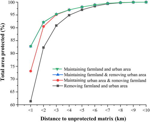
Using a gridded data set of internal distances to unprotected areas, we evaluated the statistical distribution using cumulative curves (Figure 1). In the existing configuration, which includes all urban and farmland grids, 82.83% of the NR areas were less than 1 km from the unprotected matrix; 92.23% were within 2 km, 95.39% within 3 km, 98.13% within 5 km, and 100% within 10 km.

When farmland was maintained in NRs, 82.74% of the NR areas were less than 1 km from the unprotected edges; 92.16% were within 2 km, 95.29% within 3 km, and 98.13% within 5 km. Maintaining only urban areas resulted in 73.12% of the NR areas being less than 1 km from the edges, with 90.53% within 2 km, 95.13% within 3 km, and 98.12% within 5 km. When both urban areas and farmland were removed, the proximity of NRs to unprotected edges reduced to 61.37% within 1 km, 82.31% within 2 km, 90.89% within 3 km, and 97.02% within 5 km. Statistically, removing “skylights” notably reduced the exposure level of NRs by 21.46% at a 1 km distance (contact zones) and by 9.92% at a 2 km distance.
3.2 Removing “skylights” increases the maximum depth of nature reserves
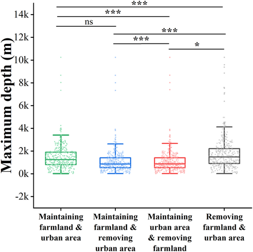
Only one NR polygon exhibited a maximum depth greater than 10 km, while 97.52% of the polygons had a maximum depth of less than 5 km (Figure 2). Through the K-W test and subsequent pairwise comparisons (Tukey Kramer Nemenyi and Dunn's all-pairs test), we evaluated the impact of two types of “skylights” on NRs' maximum depth. The results revealed significant differences among the four scenarios (chi-square (χ²) = 132.27, df = 3, p < 0.001). Compared with those in the control group, where both urban areas and farmland were removed, the maximum depth of NRs increased significantly (p < 0.001). Likewise, removing just farmland significantly increased the maximum depth of NRs (p < 0.001). However, the removal of only urban areas did not significantly affect the maximum depth (p = 0.983) (Figure 2). Therefore, “skylights” significantly reduce the maximum depth of NRs, and their removal, particularly of farmland “skylights” can substantially enhance this aspect (Figure 2).

In the mountainous region of Guangdong Province, considering the farmland “red line” policy, removing farmland “skylights” of less than 3 mu would lower the 1 km exposure level from 82.83% to 80.39%. This represents an 11.73% improvement, which, when combined with the optimal scenario-removing all “skylights” is notable, yet it does not significantly affect the maximum depth (chi-square (χ²) = 2.20, df = 1, p = 0.138) (for gradient analysis, see Tables S1 and S2). Conversely, when “skylights” of less than 5 mu were removed, there was a significant increase in maximum depth (chi-square (χ²) = 4.14, df = 1, p = 0.042), as shown in Table S2.
4 DISCUSSION
The exposure of NRs to unprotected areas has multiple implications for long-term nature conservation and human well-being. Compared to global levels, where one-third of protected areas are less than 2 km from their boundaries (Schauman et al., 2023), our study found that in Guangdong Province, more than 80% of the NR areas are within 1 km of human stressors. If “skylights” were removed, these high levels of exposure would largely decrease, and the maximum depth of NRs would significantly increase.
In the integration and optimization process of NRs, dealing with farmland “skylights” poses more significant challenges than urban areas. Farmlands and NRs often share similar distributions, being located in remote, less economically developed regions or at city peripheries (Margules and Pressey, 2000). A major issue is the Chinese government's commitment to maintaining 1.87 billion mu of farmland, preventing some of this land from being converted into protected areas (Ministry of Natural Recources of the People's Republic of China, 2023). Therefore, in terms of quantity, distribution characteristics, and restrictive policies, farmland has inevitably become the primary type of “skylight”.
Furthermore, from a landscape-human health connection perspective, the prevalence of farmland “skylights” within NRs may play a key role in future pathogen spillover and pesticide pollution across natural habitat-matrix boundaries. These interactions have historically led to disease outbreaks, population declines, and even pandemics among wild populations (Faust et al., 2018; Jones et al., 2008; Tilman et al., 2001; Wilkinson et al., 2018).
Additionally, “skylights” reduce the maximum depth of NRs, leading to discontinuous natural habitats and directly affecting species dispersal. Maximum depth is strongly correlated with the effective size of the protected area (Schauman et al., 2023), which indicates that protected areas with greater maximum depths usually exhibit better conservation performance. Urban areas and farmland, which are landscapes with high degrees of human modification, are generally unsuitable for wildlife and often obstruct species movement (Cao et al., 2020). Consequently, “skylights” perforate, disrupt, and fragment the continuous natural environment of NRs, potentially compromising the ability of governments to effectively safeguard nature in the long term (Game, 1980).
The small size and anomalous shape of Guangdong's NRs also affect their exposure levels and maximum depth. These NRs show a marked decrease on average size across national (225.68 km2), provincial (83.32 km2), municipal (39.43 km2), and county levels (19.59 km2). National NRs constitute a minor fraction (3.98%) of total NRs but cover 20.24% of the total protected areas. Smaller reserves inherently face higher exposure levels, regardless of proximity to other NRs. Typical long and narrow-shaped NRs, such as those for amphibians, reptiles, and fishes in Guangdong, which are normally established along rivers, usually have higher exposure levels due to their extensive boundary lines and lower maximum depths despite not always hosting the most biodiversity.
It is important to note that this study has several limitations. It mainly considers farmlands as exposure stressors within NRs, overlooking diverse stressors from outside, and uses maximum depth to represent effective NR size. It also excludes the “skylights” formed by mining areas due to limitations of remote sensing data, possibly leading to underestimated exposure levels.
Despite these limitations, our study highlights the increasing exposure levels produced by farmland “skylights” between NRs and unprotected areas during integration and optimization. The effect of these “skylights” on conservation effectiveness warrants further exploration. We recommend initially targeting “skylights” smaller than 3 mu (0.02 ha), prevalent within NRs, aligning with existing agrarian policies to reduce exposure levels. Addressing larger “skylights” should follow to achieve better conservation outcomes.
AUTHOR CONTRIBUTIONS
Haiyang Gao: Data curation; funding acquisition; methodology; resources; writing—original draft. Di Zhu: Conceptualization; formal analysis; supervision; validation; writing—review and editing.
ACKNOWLEDGMENTS
Thanks to Yan Hua, Yongbin Long and Yuanmu Yang for acquisition of the nature reserve data. This research was funded by the Science and Technology Project of Guangzhou (2023A04J0836). We are very grateful for the valuable comments from Professor Ahimsa Campos-Arceiz and two anonymous reviewers.
CONFLICT OF INTEREST STATEMENT
The author(s) declare no conflicts of interest.
Open Research
DATA AVAILABILITY STATEMENT
Data available on request from the authors.


