Recent advances in the investigation of a slow-moving landslide in the Three Gorges Reservoir area, China
Abstract
Many slow-moving landslides in the Three Gorges Reservoir (TGR) area exhibit episodic movement patterns in response to variations in the reservoir water level and seasonal rainfall. These landslides are typically characterized by pre-existing shear zones composed of thick, clay-rich layers that are sensitive to hydrological forcings. The residual shear strength of these shear zones is believed to control the dynamic movements of these landslides. In this article, we review the recent advances in the investigation of a large slow-moving landslide, the Huangtupo landslide, in the TGR area. This landslide has been chosen as a benchmark for studying similar landslides in this area. This review focuses mainly on the research carried out by the authors and their collaborators over the last 5 years on topics including the landslide mechanisms and forcings, rheological behaviors and constitutive models of the landslide materials, the numerical simulation of clastic shear-zone soils, and the effects landslide-induced tsunamis would have on the ships in the reservoir. In addition, new perspectives and challenges for future research on slow-moving landslides are provided.
1 INTRODUCTION
The Three Gorges area in China has been a typical landslide-prone area since ancient times owing to its steep topography and fragile geology. The operation of the Three Gorges Reservoir (TGR) has significantly intensified these landslide activities since the first impoundment in 2003 (Tang et al., 2019). In particular, the fluctuation of the TGR water level has reactivated many large, ancient landslides whose toes are submerged in the reservoir. Some of these newly reactivated landslides are characterized by fast and furious movements (Kang et al., 2020, 2022); one example is the Qianjiangping landslide that occurred shortly after the initial TGR impoundment, causing 24 deaths, destroying 346 houses, and capsizing many ships (F. Wang et al., 2004). In contrast, other landslides may move slowly, with the sliding masses slipping a few centimeters to a few meters each year, and this creep phase can persist for years to decades. These types of phenomena are categorized as slow-moving landslides, which often involve large-scale mass movements with relatively small displacements. These characteristics make slow-moving landslides difficult to detect in the field; as a result, many important infrastructures have been built on these landslides (Gong et al., 2021; Tang et al., 2019). However, the creep of earthen material could evolve into a deadly landslide that may speed up dramatically and subsequently transition into a catastrophic landslide, which can result in thousands of casualties.
Currently, many large landslides in the TGR area, such as the Quchi landslide (Luo et al., 2019), Outang landslide (J. Wang, Schweizer, et al., 2021), Muyubao landslide (Huang et al., 2020), and Huangtupo landslide (Tang, Li, Hu, Su, et al., 2015), remain unstable and exhibit creep with episodes of acceleration and deceleration (Tang et al., 2019). Although some of these landslides have been partially reinforced to slow down their movements, the potential risk of catastrophic collapse remains considerably high owing to periodic variations in water pressure (J. Wang et al., 2014), the deterioration of sliding materials (Cappa et al., 2014), and/or the occurrence of extreme events such as earthquakes and rainstorms (Yin et al., 2009). Therefore, these hazards seriously threaten the safety of the TGR, waterways, and local residents.
To date, more than 4000 landslides (mainly including rockslides, rock falls, toppled rock blocks, and debris slides), with a total volume of 4.24 billion m3, have been detected in the TGR area (Tang et al., 2019). It is unlikely that a detailed investigation of each landslide will ever be performed due to budgetary limitations. Therefore, establishing a benchmark for slow-moving landslides in the TGR area is of great significance; such a reference would make it possible to study various problems more deeply and comprehensively despite limited research funds. To this end, one of the largest slow-moving landslides in the TGR area, the Huangtupo landslide, was selected as the benchmark object due to its multiple relocation history and landslide-prone geology stratum. In 2012, the Badong field test site was established by the Three Gorges Research Center for Geohazards (TGRC). The test site includes a large-scale investigation tunnel with auxiliary adits and observation windows beneath the Huangtupo landslide and an extensive in situ monitoring system on the slope surface. The test site becomes an engineering geologist's field station to study landslides, especially those in the TGR area. It also services as an educational carrier of landslides prevention and mitigation (Juang, 2021). Since then, the Huangtupo landslide has become a key case study for better understanding the mechanisms of slow-moving landslides in the TGR area.
In this paper, we present the recent advances in the investigation of the Huangtupo landslide carried out by the authors and their collaborators during the last 5 years. This review focuses mainly on the research of the landslide mechanisms and forcings, rheological behaviors and constitutive models of the landslide materials, the numerical simulation of clastic shear-zone soils, and the effects landslide-induced tsunamis would have on the ships in the reservoir.
2 BACKGROUND OF THE HUANGTUPO LANDSLIDE
The Huangtupo landslide developed on the south bank of the Yangtze River valley with the bedrock dipping toward the valley. It is a well-documented slow-moving landslide in the TGR area and has attracted the attention of scholars worldwide due to its large size, complex structure, and potential risk, which has led to the relocation of thousands of residents (Figure 1a). Gong et al. (2021) reported that the first relocation of the Badong County seat can be traced back to the Song dynasty (960−1279 CE) due to an ancient landslide event, while the last two relocations were linked to the Three Gorges Dam project since the early 1980s. Due to the rising water level following the impoundment of the Gezhou Dam in 1982, the old county seat was moved from the town of Xinlin, which is below the reservoir water level, to the Huangtupo area. However, the Huangtupo landslide was reactivated after the construction of the county seat was nearly completed. As a consequence, the town was relocated again during the period from 2008 to 2018, resulting in the second resettlement of approximately 17,000 residents.
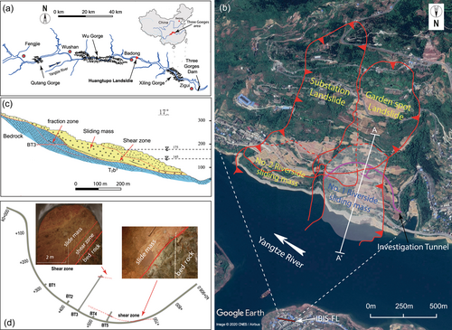
According to the investigation surveys conducted in 2001 and 2009, the Huangtupo landslide is a complex sliding mass formed over a period spanning at least 100,000 years by multiple sliding masses (Tang, Li, Hu, Su, et al., 2015). A plan view of the Huangtupo landslide is shown in Figure 1b. On the surface, the landslide is divided by a valley into two groups of sliding masses. Each group is composed of two sliding masses, one on top of the other. The crown elevation of the landslide is approximately 600 meters above sea level (m.a.s.l.), and its toe varies from 50 to 90 m.a.s.l. The foreside sliding masses, the No. 1 and No. 2 riverside sliding masses, are adjacent to the Yangtze River, and their toes are submerged in the river, which has water levels varying from 145 to 175 m.a.s.l., as regulated by the Three Gorges Dam.
The bedrock in the Huangtupo area consists of clastic and carbonate rocks of a Middle Triassic formation (T2b) in the Badong Group. The general dip direction of the bedrock is N25°E, with the dip angle varying between 30° and 50°. The front part (No. 1) of the riverside sliding masses is composed of loose rocks and soil debris originating from the third segment of formation (T2b3) in the Badong Group. The rear and deep regions comprise disturbed rock (Figure 1c). As shown in Figure 1d, the investigation tunnel at the Badong field test site includes the main tunnel, which is connected to five branch tunnels named BT1−BT5. The test site provides comprehensive multifield, multisensor monitoring systems for monitoring the Huangtupo landslide. Since the tunnel group is built inside a large reactivated reservoir landslide, it serves as a unique in situ testing platform for various in situ tests. More details regarding the Badong field test site can be found in the literature (Juang, 2021).
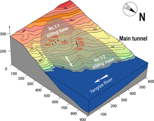
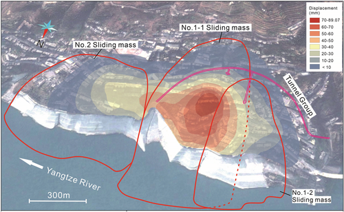
The excavation of this tunnel group exposed two main shear zones located both in the main tunnel and in branch tunnels BT3 and BT5. Tang, Li, Hu, Su, et al. (2015) carried out U-Th dating tests and revealed that the ages of the shear-zone soils in BT3 and BT5 are 40 and 100 ka, respectively, indicating that the shear zones in BT3 and BT5 are not the same layer. Accordingly, J. Wang et al. (2018) proposed a double shear surface model of the Huangtupo No. 1 riverside sliding mass. As shown in Figure 2, the No. 1 riverside sliding mass can be further divided into two subsliding masses, that is, the No. 1-1 sliding mass and the No. 1-2 sliding mass. The deformation of the Earth's surface caused by landslide movements is monitored by the Synthetic Aperture Radar (SAR) interferometry system, a ground-based interferometric SAR developed by IDS GeoRadar s.r.l. This monitoring system was installed on the other side of the Yangtze River to cover the entire landslide area (Figure 1b). According to the latest monitoring results by J. Wang, Wang, et al., 2021 the surface displacements that accumulated from January 2016 to December 2017 are shown in Figure 3. This figure reveals that the center of the No. 1 riverside sliding mass contributed the most deformation (up to 9 cm), indicating that the No. 1-1 riverside sliding mass is the most fragile part of the landslide, undergoing the most deformation. Although the displacement rate of the sliding mass has been not large enough to trigger sudden sliding into the adjacent Yangtze River, the continuous creep displacement of this landslide still poses a great threat to the safety of surrounding residents and the ships in the Yangtze River.
3 FORCINGS AND MECHANISMS OF CREEP MOVEMENT
Since the completion of the tunnel group in December 2012, the creep movement of the landslide has resulted in many cracks in the lining and pavement of the tunnel. The development of these cracks offers direct evidence of landslide movement along the basal shear zones (J. Wang et al., 2016; S. Wang, Wu, Wang, et al., 2018). Therefore, several extensometers have been installed in the tunnel to measure the development of these cracks since 2013. The locations of the extensometers in the investigation tunnel are shown in Figure 2. The extensometers were installed in locations where the shear zones were exposed and were emplaced perpendicular to the cracks to obtain the width variation.
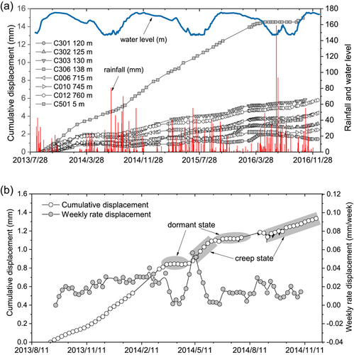
Figure 4a shows the accumulated displacement rates of selected cracks from August 2013 to December 2016 in conjunction with the variations in the TGR water level and daily rainfall. The monitoring results of eight cracks, including three cracks in the main tunnel, four cracks in BT3, and one crack in BT5, are presented. During the monitoring period, crack C501 experienced deformation of 15 mm in the last 4 years, yielding the largest rate of displacement among these cracks. The other cracks attained relatively smaller displacements. The development of these cracks indicates that the movement rate of the shear zone in the No. 1-2 sliding mass is larger than that in the No. 1-1 sliding mass. In addition, the reservoir water level and rainfall can influence the development of cracks. The propagation of the cracks coincides with periods of intensive rainfall and significant declines in the TGR water level. As shown in Figure 4b, the development of the cracks shows intermittent phases of acceleration and deceleration in the apparent dip of the shear surface and exhibits a stepwise creep tendency (S. Wang, Wu, Wang, et al., 2018). This result is in excellent agreement with the superficial monitoring data measured from GPS and InSAR (Liu et al., 2013; Tang, Li, Hu, Wang, et al., 2015; Tomás et al., 2014; J. Wang et al., 2016); that is, the landslide has experienced alternate accelerating and decelerating movements. Affected by some external factors, the soil within the shear zone is undergoing two deformation processes: a creep phase with a varying creep rate and a dormant phase occurring in different periods (S. Wang, Wu, Wang, et al., 2018).
It is well known that the soil in a shear zone is subcritically stressed, that is, subjected to stresses that are slightly lower than their instantaneous strength (S. Wang, Wu, Wang, et al., 2018). Hence, progressive failure and structural damage can accumulate within the shear zone (Agliardi et al., 2020). During these processes, two main mechanisms may occur: (i) The accumulation of localized shear brings the soil to a residual state, that is, the state in which the soil can reach its ultimate stress strength after a large displacement. In this residual state, the shear resistance along the shear surface is supposedly independent of the initial structure and stress history; instead, the shear resistance depends on both the composition of the solid skeleton and on the pore water pressure and its degree of saturation. (ii) When the driving force reaches a certain threshold compared to the residual strength, the soil along the basal shear zones begins to creep.
Studies based on experiments and in situ observations have shown that shear zones are particularly sensitive to hydrological forcings (Agliardi et al., 2020; Hu et al., 2020). While landslides can experience steady creep for years under drained conditions, hydrological perturbations can alter the stress state within the shear zones, resulting in sudden or delayed pulses of acceleration, long periods of sustained and steady displacement rates, or runaway rupture leading to a catastrophic collapse.
As shown in Figure 5, many factors, such as fluctuations in the reservoir water level, rainfall, and drainage, may influence the viscous displacement of the landslide. Shear zones are susceptible to low-magnitude external forcings (such as small rain events following periods of relative quiescence). Any change in the aforementioned factors could serve to perturb the landslide, either accelerating or decelerating its viscous movement. For instance, Liu et al. (2013) and Tomás et al. (2014) analyzed the deformation of the Huangtupo landslide based on InSAR data and reported that the upper part of the landslide is affected by seasonal rainfall, while the lower part is affected by periodic water level fluctuations in the reservoir.
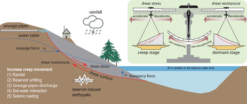
Furthermore, J. Wang et al. (2014) proposed a conceptual model for analyzing the relation between episodic landslide movements and the variation in the hydrological conditions of the landslide. Tang, Li, Hu, Wang, et al. (2015) investigated the movement pattern of the Huangtupo landslide in the context of groundwater variations and seasonal rainfall. J. Wang et al. (2016) compared both the superficial and the deep deformation of the Huangtupo landslide and discovered that water level variations and seasonal rainfall have different effects on the movement of the Huangtupo landslide. Tang et al. (2019) classified TGR landslides into seepage-driven or buoyancy-driven landslides: in seepage-driven landslides, deformation occurs mainly when the reservoir water declines, while in buoyancy-driven landslides, deformation occurs mainly when the reservoir water level is high. According to this mechanism, the Huangtupo landslide is a typical seepage-driven landslide; these types of landslides are more likely to develop in low-permeability sliding material, and since it is difficult for the pore water pressure to dissipate when the reservoir water level drops suddenly, an outward seepage force is produced that tends to destabilize the landslide.
In addition to the hydro-mechanical effects caused by rainfall and fluctuations in the reservoir water level, the mechanical behavior of the shear-zone soil is another important factor controlling the landslide movement. Many studies have pointed out that the residual strength of a shear-zone soil is dependent on the rate of displacement; accordingly, three mechanisms, that is, strengthening, weakening, and neutral effects, have been proposed to indicate the effects of the displacement rate (Scaringi & Di Maio, 2016; Scaringi et al., 2018; Tika et al., 1996). A soil may show slight rate-weakening behavior at low rates and rate-strengthening behavior at comparatively higher rates (Scaringi et al., 2018). In our previous studies, we conducted residual-state creep tests by using a ring shear machine and revealed that the effects of the displacement rate on the residual strength may be attributed to the episodic and time-variable acceleration of landslide motion; it is thus rational to speculate that rate-strengthening behavior can prevent the movement of the landslide, giving rise to a dormant stage, while rate-weakening behavior is usually responsible for accelerated creep (S. Wang, Wu, Wang, et al., 2018). Other forcings, such as the soil-water interactions due to wetting-drying cycles, water infiltration from sewage piles, and reservoir-induced earthquakes, may also weaken the strength of the shear-zone soil and thus increase creep movements.
The main conclusion drawn from the above review is that the creeping movement of the Huangtupo landslide is predominantly governed by its self-weight. Affected by some external hydro-mechanical factors, the soil within the shear zone is undergoing two deformation processes: the creep phase at different creep rates and the dormant phase with different periods. Therefore, more efforts should be paid to the rheological behavior of the shear zone materials.
4 RHEOLOGICAL BEHAVIOR OF THE SHEAR-ZONE MATERIALS
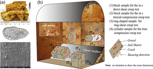
The Huangtupo landslide is characterized by a double-layer structure composed of a shear zone comprising thick clay-rich layers that divide the underlying bedrock from the overlying sliding masses. As shown in Figure 6a, the shear zone is composed mainly of brownish silty clay with gravel. To date, most studies concerning the mechanical behaviors of shear-zone materials have focused on their strength and deformation characteristics. Thus, the influences of various factors, such as the mineral composition, overconsolidation ratio, shear rate, and microstructures, on the shear strength of shear-zone soils have been widely investigated. Compared to mechanical testing research, however, the rheological behavior of shear-zone soils has received little attention.
Generally, for slow-moving landslides, localized sliding along the main shear surface is the prevailing type of movement. The creep deformation of shear zones has long been ascribed to the accumulation of microstructural defects and the progressive formation of failure surfaces in the soil under sustained loading. On a long-term scale, creep contributes to so-called viscous displacement, which usually accounts for a majority of the whole movement of a slow-moving landslide (S. Wang, Wu, Wang, et al., 2018). Therefore, it is crucial to investigate the rheological behavior of the shear-zone materials.
The TGRC has proposed a comprehensive test plan that includes both in situ and laboratory creep tests using various testing approaches, for example, in situ and laboratory triaxial compression creep tests and in situ and laboratory shear (direct shear and ring shear) creep tests. Figure 6 shows the in situ test site in the investigation tunnel for sampling and in situ tests. Specifically, S. Wang, Wu, Wang, et al. (2018) carried out creep tests on a ring shear machine to study the residual-state creep behavior of intact shear-zone soils. Li et al. (2019) investigated the creep behavior of intact shear-zone soils through triaxial creep tests in the laboratory. Furthermore, Tan et al. (2018) reported the results of in situ triaxial compression creep tests carried out in the BT3 branch tunnel, while S. Wang, Wang, et al. (2020) studied the rheological behavior of the shear-zone soils by carrying out in situ direct shear creep tests on the shear surface of the Huangtupo landslide; the results of these creep tests are shown in Figures 7 and 8. It can be observed that no accelerated creep (creep failure) occurred in either the laboratory or the in situ triaxial compression tests. In contrast, residual-state creep tests on a ring shear machine yielded creep failure when the sustained shear stress was slightly larger than the residual strength  . Creep failure was also observed in the in situ direct creep test when the sustained shear stress was slightly smaller than the predicted peak strength. These results indicate that the shear-zone soil is highly sensitive to the variation in the stress state, so any change in the stress state within the shear zone may trigger landslide movement.
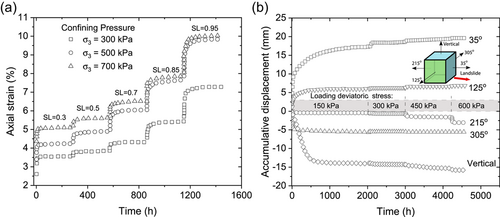
 = 500 kPa (Tan et al., 2018).
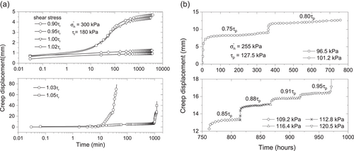
 ,
,  , and
, and  denote the residual shear strength, creep failure strength, and effective normal stress, respectively, in the shear creep tests.
5 MULTISCALE MODELING OF CLASTIC SHEAR-ZONE MATERIALS
The shear zones within the Huangtupo landslide are characterized by clastic materials, mainly fine-grained soils composed of sand, silt and clay, and a percentage of coarse particles originating from the crushing of underlying bedrock or as lithic fragments from the overlying landslide colluvium, as shown in Figure 6a. Generally, the shear-zone materials feature a relatively weak shear strength, a certain degree of overconsolidation, and componential inhomogeneity (S. Wang, Wu, et al., 2021). These properties pose many challenges for testing and modeling. Conventional laboratory tests on small samples are not suitable for studying large grains, while large-scale tests and field surveys are expensive and time-consuming. As a result, numerical simulations can be adopted to characterize the mechanical behaviors of such complex materials under various testing conditions, such as the simulations of soil-rock mixtures by Xu et al. (2008) using the finite element method (FEM) and those of clastic shear-zone materials by Jiang et al. (2016) using the finite difference method (FDM). Selecting an appropriate constitutive model forms the basis for modeling the mechanical behaviors of clastic shear-zone soils. For most relevant numerical studies, the mechanical and deformation responses of soils are modeled by the Mohr−Coulomb failure criterion, which gives rise to an ideal elastoplastic response in soil. Obviously, such simulations are not able to capture the nonlinear stress response, critical state, and consolidation history of the clastic soil in the shear zone. Recently, Zou et al. (2020) proposed a shear constitutive model based on experiments on shear-zone materials using a ring shear machine that is capable of modeling the strain behavior and can be used for landslide stability analysis. However, this model is not suitable for numerical simulation.
 ()
() and
and  are the stress and strain rate tensors, respectively;
  is the Cauchy stress tensor.
  and
and  with s being the structure tensor for overconsolidation;
  is a material parameter; and
  and
and  are factors controlling the stiffness and volumetric response, respectively, of the soil. This model is quite simple and requires only five parameters for overconsolidated soils. Compared to other constitutive models, such as the widely used Cam−Clay model, this model is much simpler and requires fewer parameters. Therefore, we recently applied this model to describe the clastic shear-zone soil within the Huangtupo landslide (S. Wang, Wu, et al., 2021).
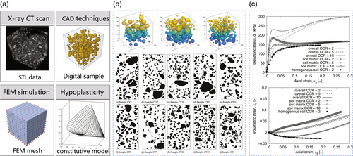
As shown in Figure 9a, the clastic soil samples are represented by a cube of dimensions 100 mm × 100 mm × 100 mm containing uniformly distributed coarse particles in the size range from 5 to 10 mm. The spatial distribution of coarse particles in an intact soil sample is obtained by making use of X-ray CT scanning. With the help of a CT scanner, digital models of clastic soil samples can be reconstructed based on their CT images; therefore, the geometric and morphological characteristics and the directionality of coarse particles can be quantitatively analyzed using reconstructed digital models (see Figure 9b). The numerical model is generated by a Python program that can be imported into the FEM solver Abaqus for computation and subsequent processing. In this way, the soil and gravels and boundary conditions of variable-element tests, for example, triaxial compression and triaxial creep tests, can be numerically discretized in a straightforward manner. In these numerical tests, the soil matrix is modeled by the hypoplastic model (1), while the gravels are regarded as elastic media. The mechanical responses of both the soil matrix and the clastic shear-zone soils under a triaxial loading state can be extracted separately, as shown in Figure 9c.
6 LANDSLIDE-INDUCED TSUNAMIS AND THEIR IMPACTS ON SHIPS
It is recognized that coast landslides are among the major causes of tsunamis. Many landslide-induced tsunamis cause huge economic loss to coastline areas and island countries, such as British Columbia in Canada, Alaska, and Japan. Geertsema et al. (2022) reported a massive landslide in a remote British Columbia valley caused by a retreating glacier on November 28, 2020. This landslide created a 100-meter-tall tsunami, which wiped out kilometers of salmon habitat, and was detected as far away as Australia. The glacial retreat also accounted for landslides and tsunamis in Alaska, such as the Taan Fiord 2015 tsunami event (Higman et al., 2018). This event was numerically studied by Franco et al. (2021) through Flow3D, a finite-volume-based CFD software. Earthquake is another important factor causing landslides and corresponding tsunamis. It was reported that the 2011 Japan tsunami, which killed up to 20,000 people and caused the partial meltdown of the Fukushima nuclear plant, was made worse by an underwater landslide, as numerically investigated by Tappin et al. (2014). Compared to the landslide-induced tsunamis in coastline areas, the inland events, such as that occurred in reservoir areas, are smaller in scale while the risk is not negligible. The Vajont landslide in the Italian Alps, for instance, caused a mega-tsunami, overtopped the reservoir dam and killed as many as 2500 people in 1963 (Ward & Day, 2011). This event was recently modeled with an SPH–DEM coupling method (Xu et al., 2022).
Similar secondary disasters also happened in the TGR (F. Wang et al., 2004; Xiao et al., 2015). To minimize the risk posed by the Huangtupo landslide, the residents of the landslide started to be evacuated in 2008. The complete evacuation spanned the last decade, with all buildings being clear by the end of 2018. Nevertheless, the landslide still poses a significant threat to neighboring residential areas. Once a failure occurs, a landslide-induced tsunami may severely threaten Lejiaping District, a small town with a population of 1200, located on the bank of the TGR opposite the Huangtupo landslide. In addition, the induced tsunami may destroy vessels on the Yangtze River at that time. Notably, hundreds of inland water vessels pass through the Huangtupo reservoir area every day, and the number of large ships has continuously increased since the opening of the Three Gorges ship lift. Hence, J. Wang, Wang, et al. (2021) evaluated the risk of landslide-induced tsunamis on ships in the TGR through a smoothed particle hydrodynamics (SPH) simulation. Figure 10 shows the 3D SPH model with the potential sliding mass, that is, the No. 1-1 sliding mass. In addition, two reservoir conditions at low and high water levels (145 and 175 m.a.s.l.) are considered to reflect the normal operation of the TGR.
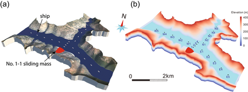
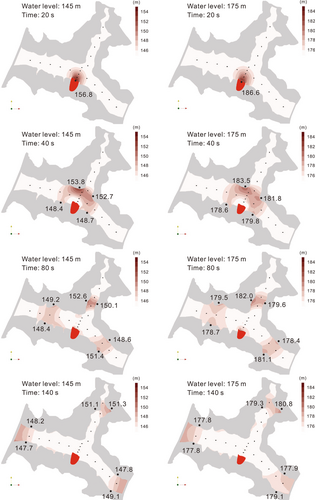
Figure 11 shows the propagation and wave height data over time for both scenarios with reservoir water levels at 145 and 175 m.a.s.l. The numerical simulations show that the maximum wave run-up is approximately 12 m, indicating the possible magnitude of the tsunami. Only after approximately 40 s does the tsunami reach the river banks of the Leijiaping area on the opposite side of the Huangtupo landslide. In addition, the highest wave run-ups are found in the Leijiaping area. Under the high reservoir scenario with a high water level (i.e., 175 m.a.s.l.), the wave run-up may not seriously threaten buildings and roads with elevations above 200 m.a.s.l. In short, the simulations indicate that humans and properties within 6 m above the water levels of the Yangtze River and 8 m above the water levels of its tributaries are at risk of landslide-induced tsunamis.
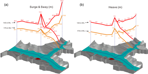
The risk of ships being destroyed due to landslide-induced tsunamis is also evaluated. Figure 12 shows the results of the surge, sway, and heave of ships. At a low reservoir water level (145 m.a.s.l.), the maximum surge and sway of 110 m is observed for ship N1 closest to the landslide (Figure 12a). As wave propagation continues, the surge and sway values on the east and west sides gradually decrease to approximately 24 and 34 m, respectively. Notably, the north side shows different phenomena: the surge and sway values of the ships therein gradually increase after entering the tributary. Depending on the reservoir water level, the maximum heave of ships may reach between 7 and 8 m (Figure 12b). Toward the east and west, the heave gradually reduces to approximately 2 m. In general, the surge, sway, and heaves of floating objects decrease with distance from the wave source and exhibit more rapidly decreasing velocities in the close vicinity of the landslide ( 50 m), although roll motions may still present risks of loss and injury due to the movement of cargo and the falling of passengers and crew.
7 SUMMARY AND FUTURE PERSPECTIVES
The Huangtupo landslide is controlled by complex interactions among internal factors, such as the state of the landslide material or pore fluid, and external forcings, such as rainfall, fluctuations in the TGR water level, and the occurrence of reservoir-induced earthquakes. As a result, the Huangtupo landslide displays a wide variety of kinematic behaviors that are dominated by the dynamic balance between the shear stress and residual shear strength of the shear zones. Over the last decade, extensive research has been carried out on the Huangtupo landslide, including studies on its internal structure based on the excavation of an investigation tunnel beneath the landslide, its kinematic features according to the monitoring network dedicated to the Huangtupo landslide, its shearing and rheological behaviors through various testing methods, numerical simulations of the clastic shear-zone materials with the help of FEM analyses, and the risks posed by landslide-induced tsunamis and their potential impacts on ships based on SPH simulations. This study has meaningful implications for understanding the mechanisms and risks of similar slow-moving landslides in reservoir areas.
Although significant advances have been made in the aforementioned research on the Huangtupo landslide, some aspects have yet to be thoroughly explored. Experimental investigations of the mechanisms responsible for the sliding of the Huangtupo landslide are still insufficient due to the lack of quantitative analyses. Many laboratory tests involving small-scale specimens cannot reflect the real stress conditions and the kinematic responses of landslides to hydrological changes. Moreover, no in situ experiments have been performed considering both the rate-dependent behavior and the partial saturation of landslides. On the other hand, theoretical and numerical analyses of the landslide process along shear zones remain challenging due to the lack of appropriate constitutive models and numerical tools considering creep failure. Although many advanced constitutive models have been developed in light of soil mechanics, only a few of them can describe the relevant hydro-mechanical coupling, and a robust model that can capture the acceleration of creep and the resulting onset of catastrophic failure has yet to be developed. In addition, the classic numerical models, for example, the FEM and FDM, based on continuum mechanics are limited in their ability to simulate the localization of strain in shear zones and the large deformation that occurs after creep-induced failure. Further research on the creep movements of landslides with localized deformation is necessary to improve our understanding of the origin of catastrophic failure and to help build new numerical tools for predicting these hazards.
ACKNOWLEDGMENTS
The work carried out in this paper was funded by the Key Program of the National Natural Science Foundation of China (Grant No. U2240211) and the National Natural Science Foundation of China (Grant No. 52078393).
ETHICS STATEMENT
The authors confirm that this article does not contain any studies with animal or human subjects.
Open Research
DATA AVAILABILITY STATEMENT
The data included in this study are available upon request from the corresponding author.


