Study on the coordination of flow and sediment transport, ecological environment, and crop production in the Lower Yellow River since 2000
Abstract
The Xiaolangdi Reservoir has been operated for 23 consecutive years, greatly altering the flow and sediment processes of the Lower Yellow River. Many research have separately analyzed the changes of siltation in reservoirs and river channels, discharge capacity of the lower river channel, river regime stability, or ecological environmental benefits under water and sediment regulation. However, the multiple changes of flow and sediment transport, ecological environment, and social economy were seldom considered. We systematically and holistically explored the changes of river system in the Lower Yellow River since 2000, based on the channel erosion and siltation, channel morphology, ecosystem patterns and habitat quality, irrigation water scale, and crop production index. The results show that the discharge capacity of the main channel has been recovered significantly at a bankfull discharge of over 4700 m3/s. The ecological pattern in the Lower Yellow River and the delta has been optimized. The wetland and water ecosystem area has been remarkably increased by 125.82% and 318.54% respectively, and the saline-alkali land area has been sharply reduced by 89.65%. The habitat quality has been raised to the highest level in nearly 40 years. The irrigation water volume in the irrigation area of the Lower Yellow River has been increased by 31%, and the grain production has maintained a continuous growth for 16 years. Overall, the coordinated development level of flow and sediment transport, ecological environment and crop production in the Lower Yellow River has been continuously improved from the reluctantly coordinated level (before water and sediment regulation) to the highly coordinated level.
1 INTRODUCTION
With the largest sediment runoff and the highest sediment concentration in the world, the Yellow River has become a “perched river” due to the continuous channel siltation in the lower reaches. Especially in the 1990s, sustained medium and small floods with high sediment concentration caused severe siltation and atrophy of the main channel. Gradually, “secondary perched river” appeared, and the discharge capacity of the main channel was reduced to 1800 m3/s. Moreover, strong wandering characteristics of the Lower Yellow River also seriously threatened the flood control safety, ecological environment, and socioeconomic development.
In 2000, Xiaolangdi Reservoir was completed and put into operation, creating engineering conditions for the water and sediment regulation of the Yellow River. Since 2002, 3 consecutive years of water and sediment regulation prototype tests and ongoing water and sediment regulation engineering practices have properly regulated the flow and sediment processes, leading to relatively harmonious relationship of water and sediment, siltation reduction of reservoirs and river channels, and increased discharge capacity of the main channel of the Lower Yellow River. Therefore, water and sediment regulation has become one of the most important measures for the Yellow River governance. In the past two decades, many scholars have analyzed the changes in the Yellow River under water and sediment regulation. In terms of flow and sediment transport, studies systematically explored the mechanism of sediment discharge in reservoirs (Wang et al., 2020; Zhang et al., 2018). The impact of water and sediment regulation on the erosion and siltation of Sanmenxia Reservoir, Xiaolangdi Reservoir, and the Lower Yellow River channel was clarified (Jia et al., 2022). Zhao et al. (2022) found that there was an obvious impact on sediment discharge in reservoirs and siltation reduction in the Lower Yellow River channels. By analyzing the hydrological morphological characteristics and geomorphic process of the Lower Yellow River, Lu et al. (2022) concluded that water level and suspended sediment concentration were the main factors affecting the evolution of river landforms. Wang et al. (2020) analyzed satellite images before and after water and sediment regulation of Xiaolangdi Reservoir and quantitatively identified the estuarine changes on the basis of eliminating potential bias factors such as water level, precipitation, or tidal variation. In terms of ecological environment, Li et al. (2017) revealed that human intervention could regulate the natural state of the mainstream and estuarine environment of the Yellow River in a short time. Hou et al. (2021) investigated the particle size and nutrient content of sediment under water and sediment regulation, and found that the total organic carbon and total phosphorus content in the sediment decreased by about 40% due to river channel erosion. Zhang et al. (2021) explored how water and sediment regulation strategies influenced the phytoplankton communities in the Yellow River estuary. In terms of social economy, Wang, Xie, et al. (2022) established a multiobjective optimized operation model for Xiaolangdi Reservoir. Taking into account hydropower, reservoir siltation, and channel siltation, they found that there was a nonlinear and weak competitive relationship between hydropower benefits and reservoir siltation. Wang, Tang, et al. (2022) proposed a cooperative scheduling model for the multireservoir system in the mainstream Yellow River, which led to markedly enhanced overall performance of the system in flood control, water supply, power generation, and siltation reduction. Based on the requirements of water supply, power generation, flood control, and water and sediment regulation, Bai et al. (2023) put forward a multi-objective optimized scheduling model in the upstream Yellow River, and suggested that generating power according to the available water amount was the most effective operation mode for longer time periods and typical years.
The Lower Yellow River is a complex system. Most of the above studies are limited to a single object or a single function and lack a comprehensive exploration from a holistic perspective. Furthermore, the study period typically ranges from one to several years, failing to accurately reflect the changes of entire river system in the Lower Yellow River and estuary over the past 23 years of water and sediment regulation. This paper highlights the integrity and sustainability of the river system and investigates the multiple changes of flow and sediment transport, ecological environment, and crop production in the Lower Yellow River since 2000. It provides a theoretical basis and reference for future water and sediment regulation as well as the management of sediment-laden rivers in the world.
2 DATA AND METHODS
2.1 Study area
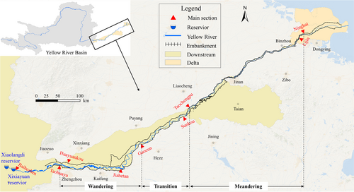
The Lower Yellow River in this paper is the area from Baihe Town below Xiaolangdi Dam to the estuary, with a channel length of 878 km. Among them, the reach from Xiaolangdi to Taohuayu is the transition section of the Yellow River from the mountain to the plain, with a channel length of 92 km. The reach from Taohuayu to Gaocun is a typical strong wandering river, with a length of 206.5 km and a width of 5–24 km, where erosion and deposition change dramatically. The reach from Gaocun to Taochengpu is a transition section from wandering to meandering river channel, with a length of 165 km and a width of 1.5–8.0 km. The reach from Taochengpu to Ninghai is a meandering river channel which is relatively smooth and stable, with a length of 322 km and a width of 1–3 km. The downstream reach from Ninghai is the Yellow River estuary section, with a channel length of 92 km (Figure 1).
The perched reach in the Lower Yellow River provides unique conditions for industrial and agricultural water supply along the river, which also guarantees the stable socioeconomic development and ecological sustainability. During the 28 years from 1972 to 1999 in the last century, the Lower Yellow River was cut off for 22 years. Especially in 1997, the Lower Yellow River was cut off for 226 days, with a length of 704 km, extending from the estuary upward to Kaifeng City in Henan Province. The frequent cut-offs in the Lower Yellow River have led to a drastic reduction of water and sediment resources in the estuary area, shrinking of the estuary freshwater wetlands, declined biodiversity, increased land salinization degree, and serious degradation of wetland ecological function.
2.2 Data source
The study data in this paper mainly involves hydrology, sediment, river morphology, ecological environment, and crop production. Among them, hydrology and sediment data were obtained from the water information network of the Yellow River Conservancy Commission, including the water level, discharge, runoff, sediment concentration, and sediment runoff of different stations and sections from 1960 to 2022. The river morphology data include the river floodplain elevation, the riverbed elevation of the main channel, the river boundary, and the flow dynamic axis position from 1960 to 2022. The ecological environment data were obtained from the Resource and Environment Science and Data Center (https://www.resdc.cn), including 7-phase (1980, 1990, 2000, 2005, 2010, 2015, and 2020) land use data with a spatial resolution of 30 m × 30 m. The irrigation water supply and crop production data from 1990 to 2020, were collected from Yellow River Water Resources Bulletin, Statistical Yearbook of Henan Province, and Statistical Yearbook of Shandong Province.
2.3 Methods
Sustainable development was first proposed in the World Conservation Strategy in 1980. Its goal is to achieve the coordination of natural, social, ecological, and economic aspects. The Lower Yellow River is a multiobjective and multilevel nonlinear system, involving complex restrictions and feedback relationships between the flow and sediment transport, regional eco-environment protection, and socioeconomic development (Cheng et al., 2014; Gorelick & Zheng, 2015; Meng et al., 2022; Sivapalan et al., 2014). Highlighting the integrity of the river system, Jiang et al. (2020) divided the river system into water-sediment (WS), eco-environment (EE), and socioeconomy (SE) subsystems according to the service function. As a whole, the three subsystems determined the operation state of the river system (Jiang et al., 2021).
- 1.
Sustainability of flow and sand transport
 ()
() is the mainstream oscillation rate, namely the difference between the oscillation amplitude in previous year and current year;
  is the mainstream oscillation acceleration, namely the difference between the oscillation rate in previous year and current year;
  and
and  are the correction parameters, which are estimated by least square method. The larger the RSIRR, the greater the mainstream wandering migration amplitude. RSIRRl = 2 and RSIRRh = 4.5 are the lower and upper thresholds of the mainstream oscillation amplitude. If RSIRR > RSIRRh, the cross-section is extremely unstable; and if RSIRR < RSIRRl, the cross-section is stable.
- 2.
Sustainability of ecological environment
 ()
() ()
() ()
() ()
()- 3.
Sustainability of social economy
The sustainability of social economy is to realize stable regional socioeconomic development within the capacity of resources and environment. The Lower Yellow River, located in the Huang-Huai-Hai Plain, is an important grain production base in China. Since Xiaolangdi Reservoir has been put into operation, it has greatly improved the water diversion guarantee rate for the Lower Yellow River irrigation area by utilizing ice flood and spring flood. Accordingly, the crop production and irrigation water volume in the Lower Yellow River irrigation area was used to evaluate the sustainability of social economy. Moreover, to eliminate the influence of water-saving technology on the water consumption of Yellow River diversion, the irrigation water volume was obtained by multiplying the actual irrigation water diversion and the effective utilization coefficient of farmland irrigation water.
- 4.
Coordinated development of flow and sediment transport, ecological environment, and crop production.
 ()
()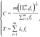 ()
() is the number of subsystems;
  is the DI of subsystems, which were obtained by the weighted average of different indicators;
  is the weight coefficient of subsystem, and considering that the three subsystems of flow and sediment transport, ecological environment and crop production play equally important roles,
  (Shi et al., 2020). To eliminate effects of dimension and order of magnitude, all indicators were standardized. The value range of D is [0,1]. The larger the value, the higher the coordination level. Based on relative studies, we divide the CCD into five levels (Ariken et al., 2021). The classification criteria are shown in Table 1.
| Coupling coordination degree | Category |
|---|---|
| [0, 0.2] | Highly uncoordinated |
| (0.2, 0.4] | Moderately uncoordinated |
| (0.4, 0.6] | Reluctantly coordinated |
| (0.6, 0.8] | Moderately coordinated |
| (0.8, 1] | Highly coordinated |
3 RESULTS AND DISCUSSION
3.1 Flow and sediment transport
The Sanmenxia and Xiaolangdi (XLD) stations are the control stations of the upper and lower reaches of Xiaolangdi Reservoir, respectively. Here, we analyzed the runoff and sediment runoff variations in the two stations during 1960–2022, as shown in Figure 2. Xiaolangdi Reservoir, as an incomplete annual regulation reservoir, does not have a strong role in regulating annual runoff, almost maintaining an equal annual inflow and outflow. But it plays a crucial role in retaining sediment. During 2000–2022, the average annual sediment runoff of the Sanmenxia station was 291 million tons, while that of the Xiaolangdi station was 111 million tons. The cumulative siltation amount of Xiaolangdi Reservoir was 4.14 billion tons and the sediment retaining ratio was 61.8%. The water and sediment regulation of Xiaolangdi Reservoir has played a vital role in controlling the elevation of the lower Yellow River channel because the lower river channel would be elevated by around 2 m without it.

The changes of erosion and siltation amount of the channel, bankfull discharge (expressed by bankfull discharges of six important sections), the elevation difference between flood plain and channel, and RSIRR in the Lower Yellow River during 1960–2022 are shown in Figure 3. It can be seen that the Lower Yellow River was silted in most years from 1960 to 1999, with a cumulative siltation volume of 3.266 billion m3, which led to a fluctuating decline trend in bankfull discharge. Especially since the mid-1980s, the discharge capacity of the main channel has been shrinking. A short-term intense scour phenomenon occurred between 1961 and 1964, primarily attributed to the water storage and sediment detention of Sanmenxia Reservoir. Due to the effects of the water and sediment regulation of Xiaolangdi Reservoir, as well as changes in the runoff and sediment runoff of the Upper Yellow River, the Lower Yellow River experienced a continuous erosion of 2.402 billion m3. Accordingly, the discharge capacity of the main channel recovered significantly. The bankfull discharge of Huayuankou, Jiahetan, and Gaocun recovered to more than 6500 m3/s, while that of Sunkou, Aishan, and Lijin recovered to more than 4700 m3/s.
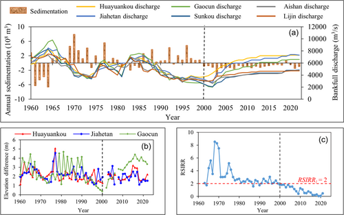
From the lateral morphological characteristics, the elevation difference between flood plain and channel of Huayuankou and Jiahetan decreased slightly around 2000, and that of Gaocun increased significantly. This indicates that the development of the secondary perched river in the wandering reach from Taohuanyu to Jiahetan had little changes, while the reach from Jiahetan to Gaochun experienced an obvious improvement. From the longitudinal morphological characteristics, the river regime of the wandering reach gradually tended to be stable on the whole. The value of RSIRR during 1960–1999 was mostly above RSIRRl, which suggests that the river regime was in an unstable state. After 2000, the river regime was effectively controlled and the value of RSIRR was below RSIRRl, as a result of the water and sediment regulation of Xiaolangdi Reservoir and the enhancement of channel regulation projects. This demonstrates that the river regime of the reach was basically in a stable state.
3.2 Ecological environment
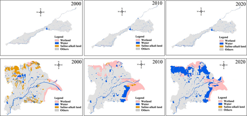
The changes of ecosystem patterns in the Lower Yellow River and delta during 1980−2020 are shown in Figure 4. It shows that the area of wetland, waters, and saline-alkali land changed dramatically in the past four decades. The wetland and water ecosystem area of the Yellow River Delta increased observably during 2000–2020, but the saline-alkali land area decreased sharply during 2000–2010. Especially, the wetland and water ecosystem area increased rapidly by 125.82% and 241.65% respectively after the operation of Xiaolangdi Reservoir (2000). It is worth noting that ecological water was continuously replenished to the Yellow River Delta National Nature Reserve during water and sediment regulation since 2008, bringing “blood transfusion” improvement to the ecological environment of the Yellow River Estuary Delta and offshore areas. As shown in Figure 6, the water ecosystem area of the Yellow River Delta National Nature Reserve increased from 49.7 km2 in 2008 to 69.0 km2, and that of Qingshuigou and Diaokou Rivers increased by 14.3 and 5.0 km2, respectively.
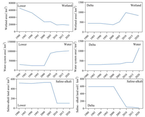
The water ecosystem area of the Lower Yellow River was small and the salinization level was severe because of frequent cut-offs before 2000. But after that, the water ecosystem area in the Lower Yellow River and the estuarine delta experienced a significant increase by 319.60% (Figure 5). The salinization level of the Lower Yellow River and the estuarine delta decreased significantly by 89.65%.
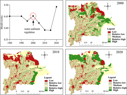
The changes of biodiversity in the Yellow River Delta during 1980–2020 were further analyzed (Figure 6). The habitat quality presented a “U-shaped” change trend in the past four decades with an increase of 8.75%. Specifically, it showed a rapid downward trend during 2000–2010, a stable trend during 2010–2015, and a rapid growth of 26.00% during 2015–2020. This increment may be related to the implementation of freshwater replenishment in the Yellow River Delta during water and sediment regulation after 2008. The increased wetland and water ecosystem area plays an important role in maintaining the ecological environment of plants and animals and improving regional ecosystem service function and biodiversity (Yang et al., 2017; Zhao et al., 2018). At present, the number of bird species in the Yellow River Delta National Nature Reserve has increased from 187 to 371.
3.3 Crop production
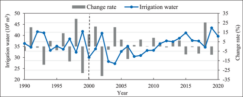
The change of irrigation water volume in the irrigation area of the Lower Yellow River is shown in Figure 7. It presents a fluctuating decline trend from 3.63 billion m3 in 1990 to 2.72 billion m3 in 2004 with a reduction of 25%. After 2004, this situation improved remarkably. The irrigation water volume increased from 2.72 to 3.96 billion m3 with an increase of 31%. This is because Xiaolangdi Reservoir redistributed annual runoff and improved the guarantee rate of water diversion in the Lower Yellow River irrigation area.
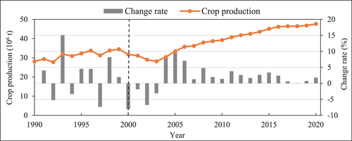
The change of crop production in the irrigation area of the Lower Yellow River during 1990–2020 is shown in Figure 8. Crop production showed a similar changing tendency to the irrigation water volume. After 2004, crop production achieved growth for 16 consecutive years with an increase of 71%. This is partly due to the continuous improvement of the irrigation guarantee rate in the Yellow River irrigation area, which has enabled crops to be adequately irrigated and has promoted higher grain yields.
3.4 Coordinated development level of flow and sediment transport, ecological environment, and crop production
Figure 9 shows the changes of DI of flow and sediment transport, ecological environment, and crop production in the Lower Yellow River during 1990–2020. The DI of the three subsystems presented an upward trend on the whole. The difference is that the DI of flow and sand transport and crop production showed a decreasing trend before 2000 and a rapidly increasing trend after 2000, while that of the ecological environment kept slow growth during the whole period. In general, the development level of crop production was highest before 2000, while that of flow and sediment transport was highest after 2000.
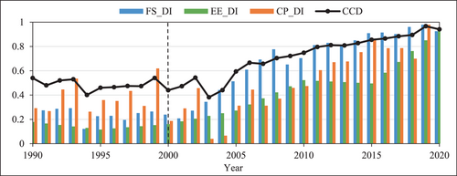
The coordinated development level of flow and sediment transport, ecological environment, and crop production was further analyzed (Figure 9). The CCD of the three subsystems was on a rise from 0.54 in 1990 to 0.94 in 2020. To be specific, CCD fluctuated between 0.4 and 0.6 during 1990–1999, and belonged to the reluctantly coordinated level. This is because the development level of the three subsystems in this period was not high. After 2000, CCD remained at the reluctantly coordinated level due to the “drag” of the crop production subsystem. This began to improve after 2004 when CCD continued to increase, and it reached the moderately coordinated level in 2006 and the highly coordinated level in 2012.
4 CONCLUSION
- 1.
The flow and sediment transport capacity of the Lower Yellow River channels was significantly improved. After 2000, the downstream channels showed continuous erosion with a cumulative erosion of 2.402 billion m3. The bankfull discharge of the main river channel recovered to more than 4700 m3/s. The river regime of wandering reaches was further controlled in a stable state.
- 2.
The ecosystem pattern in the Lower Yellow River and delta was obviously optimized. After 2000, the area of wetlands and waters increased by 125.82% and 318.54%, respectively, while that of saline-alkali land decreased by 89.65%. The ecological environment of the Yellow River Delta was greatly improved as a result of ecological water replenishment after 2008. The ecological environment index experienced a rapid increase of 26% during 2015–2020, which reached its highest level since 1980.
- 3.
The development of crop production in the Lower Yellow River continued to improve. The irrigation water volume increased from 2.72 billion m3 in 2004 to 3.96 billion m3 in 2020, and crop production also increased for 16 consecutive years from 2.8 × 10⁶ t (2004) to 4.8 × 10⁶ t (2020). This has strongly supported the high-quality development of social economy in Henan and Shandong Provinces.
- 4.
The coordinated development level of flow and sediment transport, ecological environment, and crop production in the Lower Yellow River increased sharply. Overall, the coordinated development level continuously improved from the reluctantly coordinated level before 2000 to moderately coordinated level during 2004–2015, and then to highly coordinated level during 2016–2020.
ACKNOWLEDGMENTS
This study was funded by the National Key Research and Development Program of China (2021YFC3200400), the National Natural Science Foundation of China (U2243601), the Young Elite Scientists Sponsorship Program by Henan Association for Science and Technology (2022HYTP023) and the Central Public-Interest Scientific Institution Basal Research Fund for Chinese Academy of Tropical Agricultural Sciences (HKF202114).
ETHICS STATEMENT
None declared.
Open Research
DATA AVAILABILITY STATEMENT
Author elects to not share data.


