Human affinity for rivers
Abstract
Human civilization prospers along rivers worldwide. Here, we investigated human–river relations by revealing the linkage between water and habitability for human settlements, and socioeconomic and cultural development across China. We found that human–water co-occurrence relationships are self-similar over sub-basins for different scales of stream-order in the river networks. According to the earlier complete demographic census conducted during the reign of the Qing Dynasty (1776), there has been a general tendency for inhabitants to live close to rivers, characterized by population density associated with habitability cored by water under a near-natural state, which still remains to date (2019) even after long-term population growth and human interventions. Throughout history, we have extended the linkage of human settlements to humanistic attributes with river networks, derived four different modes of human aggregation towards rivers, and elucidated the geographical diversity of river density, population density, cultural prosperity, and clusters of ethnicity, particularly the Western and the Northeast culture established in the arid (desert) areas, the Huaxia culture in the alluvial plains, the Loess/Nomadic/Southwestern Ethnic culture in the plateaus, and the Qi-Lu/Wu-Yue/Linnan culture in coastlands across the whole country. This work is also of significance to understanding long-term human–water relationships at a global scale.
1 INTRODUCTION
Throughout history, humans have chosen to live close to rivers due to the availability of agricultural and domestic water supply, natural resources, navigation, and trade (Kummu et al., 2011). Records on human affinity for rivers can be traced early to the Classic of Mountains and Rivers (Yuan, 2014) during the Pre-Qin Period (Paleolithic Period—221 bc). Alongside the world's great rivers, people have extended a new dimension of social progress, established settlements, developed riverine economic activities, and explored the intellectual and artistic domains of the human mind (Best, 2019; Hasan, 1997).
River networks are hierarchical systems with both natural and human dimensions. Statistically, rivers with different stream-orders follow certain geometric laws, notably identified by different schemes such as the Horton (1945) and Strahler (1952, 1957) stream-order rules, along which self-similarity in natural river networks has been confirmed (Y. C. Wang et al., 2018; Zanardo et al., 2013). Moreover, river density, defined as the ratio of the total stream number or channel length in a catchment to the total catchment area, is also an effective factor characterizing the degree of development of river networks, which usually corresponds to plentiful precipitation and high vegetation coverage (X. B. Chen et al., 2019). Compared with the perceived physical characteristics of river networks, there exists a gap in understanding river systems from the human perspective, for example, human settlements and behaviors. Globally, preferential downstream clustering of human settlements has been observed across continents (Fang et al., 2018). In particular, the outlets of great rivers are more attractive for human settlements compared to other coastal areas because of favorable opportunities for nature resources, geographic advantages, and ecological assets, even though humans would be more vulnerable to flood risk (Tellman et al., 2021).
The geospatial pattern of human settlements could be regarded as a symbol of the complex human–nature relationship influenced by an interplay of varying factors. Besides proximity to the river, the local land elevation and latitude are also important geographical considerations for human settlements (Kummu et al., 2016; Viviroli et al., 2020). It has been reported that around 50% of the population dwells within the area between 20°N and 40°N, where most of the world's development and poverty-related problems also co-exist (Kummu & Varis, 2011). Moreover, human settlers have made continuous strides towards socioeconomic and cultural development, mirrored by lifestyle, production, architecture, ethnic, and other social characteristics (Hasan, 1997; Singh et al., 2017). For example, human behavior has even stretched to a cultural perspective of river networks through colorful river naming practices (Y. J. Liu et al., 2010; Y. C. Wang et al., 2019), while relations between rivers and the origin of language and expansion were phylogenetically evidenced with historic human populations and their cultures (M. H. Zhang et al., 2019).
Over the centuries, the relationship between people and rivers has become more complicated due to increasing anthropogenic interference and climate change (L. Li et al., 2020; Maavara et al., 2020; Ni et al., 2022; Y. C. Wang et al., 2020; Wu et al., 2021). On the other hand, the reliance of humans on direct proximity to rivers has been buffered due to enhanced capability of water diversion and exploitation of alternative sources (Scanlon et al., 2012). Hence, population density seemed not so closely coupled with croplands spreading towards inland zones (Kummu et al., 2016). These raised widespread concerns about the diverse trajectories of settlement proximity to major rivers induced by heterogeneities of climate, urbanization, and economic development at regional and global scales (Ceola et al., 2015; Fang & Jawitz, 2019; Veldkamp et al., 2017).
In the present paper, we investigated human–river relationships through the linkage between water and habitability for human settlement, and socioeconomic and cultural development across China. Based on the earlier complete demographic census conducted during the reign of the Qing Dynasty (1776), we interpreted the preferential orientation of people toward rivers in a near-natural state. By revealing the geographical diversity of river density, population density, cultural prosperity, and clusters of ethnicities, the human–nature harmony is elucidated in conjunction with the representative modes of human aggregation through long-term development, which is also helpful for understanding human–water interactions in the rest of the world.
2 MATERIALS AND METHODS
2.1 Data sources
Digital elevation modes (DEMs) at 30 m × 30 m resolution for extraction of river networks and basin boundaries were available at https://search.earthdata.nasa.gov/search. The referenced river network data for validation and Gridded population data at 1 km × 1 km resolution for China were derived from http://www.resdc.cn/. Both the annual mean precipitation map and the climatic regionalization map of China were obtained from the Atlas of Physical Geography of China (Department of Geography Northwest Normal University, 1984). The annual average aridity index data for 1970–2000 were available at https://doi.org/10.6084/m9.figshare.7504448.v3. Terrain slope was calculated based on the 90 m × 90 m resolution DEMs available at http://www.gscloud.cn/. Population data for the Qing Dynasty (1776) at the prefecture scale were obtained from the History of Population in China, Qing Dynasty (Ge, 2001). Global population gridded data sets were assessed via https://sedac.ciesin.columbia.edu/data/set/gpw-v4-population-count-rev11. Dynastic litterateur data for China from the Zhou Dynasty to the Qing Dynasty were collected from historic classics of China (Mei, 2004). Prefecture unit boundary polygon files of China in the Qing Dynasty were derived from CHGIS (2003). The polygon file was further clipped using the present China boundary map for better comparison. Chinese provincial administrative boundary data were obtained from http://www.resdc.cn/.
2.2 Extraction of river networks
Drainage networks and the corresponding basin boundaries for China were extracted using a high-efficiency algorithm based on a size-balanced binary search tree (Bai et al., 2015). The extraction system involves five steps: (1) filling local depressions; (2) determining flow directions; (3) accumulating upslope areas; (4) identifying river channels in terms of threshold values of critical source area and local slope; and (5) vectorizing geographic features. In this study, the threshold values of critical source area (number of grid cells) and local slope were determined to be 20 and 0.01, respectively. For endorheic rivers in the Northwest China and the Tibetan Plateau, pretreatment on DEMs was undertaken (Y. C. Wang et al., 2019).
2.3 River system hierarchy
 ()
()2.4 Quantification of natural and humanistic factors
 ()
() ()
() ()
()Finally, cultural prosperity in a particular dynasty was represented by the number of litterateurs per province (NL, Person) recorded in the historic classics of China (Mei, 2004).
2.5 Correlation analysis
Relationships between factors characterizing geographic conditions, human settlements, and cultural development were identified by Pearson or Spearman correlation analysis. For all statistical analyses, a value of p < 0.01 (99% confidence level) was considered significant. IBM SPSS 19.0 statistical software was used in the relevant analysis.
3 RESULTS AND DISCUSSION
3.1 Habitability of human settlements
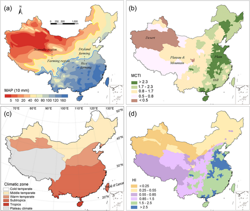
Human habitability generally depends on geographic and climatic conditions. Figure 1a shows the mean annual precipitation (MAP) across China. North-west China, with MAP < 400 mm, is a nomadic region where animal husbandry dominates. Much of the remainder of China is farmland due to substantial rainfall. The farming region can be separated about the 800 mm isohyet into dry and rice farming areas in northern and southern China. Figure 1b shows the spatial distribution of a modified compound topographic index (MCTI, Methods) based on the ratio of aridity to topographic slope. The index is higher in east China, which comprises hills and plains (MCTI > 1.7), especially in coastal and estuarine areas, but lower in west China, which contains plateau and steeply sloping mountainous regions (0.5 < MCTI < 1.7) and arid desert regions (MCTI < 0.5). Latitude, which in turn affects ambient temperature, is of the utmost importance to human well-being, productivity, and cultural development (James, 1972). Figure 1c shows the climatic zones of China, where tropical, subtropical, and warm-temperature zones lie within latitudes 20°N–40°N and are optimal for human residence and development (Kummu & Varis, 2011). Attractiveness for human settlement is quantified in terms of the habitability index (HI), which combines MCTI and latitude. As shown in Figure 1d, coastal areas (HI > 2.5) and alluvial plain areas (1.5 < HI < 2.5) of the Yangtze and the Yellow rivers are more preferable for human settlements, compared with plateau regions (0.55 < HI < 1.5) and high-latitude regions (arid desert or cold northeast China, HI < 0.55).
3.2 Human–water co-occurrence relationships at varying scales
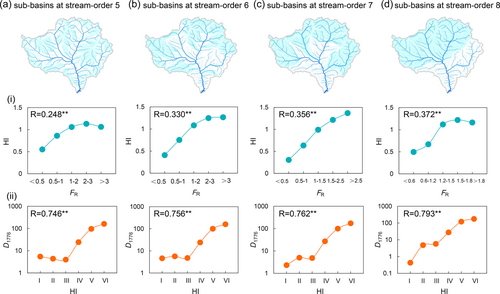
To eliminate uncertainty arising from increased human mobility in recent centuries, the near-natural population density is determined from the census information conducted in the year 1776 during the Qing Dynasty (D1776), when complete provincial demographic statistics (Ge, 2001) became commonly established and the tendency for inhabitants to live close to rivers was still strong. Then, human–water relationships in river networks could be analyzed through the linkage between natural river frequency (FR, 10−2km−2), habitability index (HI), and population density in the Qing Dynasty (D1776, Person km−2) for 9834, 2252, 508, and 112 sub-basins at different stream-orders (5–8) in China. The positive feedback of HI to increased FR reveals that conditions suitable for human aggregation occur more frequently in areas of higher river density (Figure 2i). D1776 also shows a significant positive correlation with HI, confirming that HI is an effective indicator of the scale of human aggregation (Figure 2ii). The consistency of results across different scales demonstrates a robust fractal structure of human–water co-occurrence relations in hierarchical river networks despite the spatial heterogeneity of geographical environments and diversity of human aggregation patterns and lifestyles.
3.3 Preferential orientation of inhabitants towards rivers
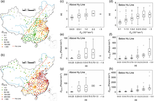
The general tendency for inhabitants to live close to rivers since ancient times is fairly identified by the so-called Hu Line (W. Qi et al., 2016), which divides China into two regions (Figure 3a,b). The southeast region of China (below the Hu Line) is more attractive for human settlement due to its natural advantages of abundant water resources in addition to fertile soil and plentiful sunlight. The number of rivers with catchment areas greater than 100 km2 per unit area (FR) in the regions below the Hu Line is 4.37 × 10⁻³ km−2, which is 21% higher than that in regions above the Hu Line. The mean value of HI in the regions below the Hu Line (1.87) is fourfold higher than that above the Hu Line (0.45). From the census information, the mean D1776 in the region below the Hu Line (101 Person km−2) is significantly greater than that above the Hu Line (15 Person km−2). A higher correlation between FR and HI (Figure 3c,d), as well as FR and D1776 was observed in areas below the Hu Line, suggesting an essential role of rivers in human aggregation in areas with dense river networks. The mean D1776 increased with FR below the Hu line (Figure 3e), but remained unchanged above the Hu line (Figure 3f), suggesting a diversity of human aggregation patterns and lifestyles across the whole country. Interestingly, the distributions of population density in 1776 (Figure 3a) and 2019 (Figure 3b) are generally similar from the perspective of the Hu Line, even though China has experienced rapid population growth and urbanization. Meanwhile, the dependence of D1776 and D2019 on HI is also at a similar level, particularly in the regions below the Hu Line (Figure 3e,f). It is expected that river networks would continue to play key roles in shaping spatial patterns of human settlements and clusters of economic entities in the absence of dramatic climate change.
3.4 Characteristics of typical human aggregation modes
By considering the geographical environment, it is possible to map four main human aggregation characteristics (Figure 4). Each set of characteristics has a corresponding range of habitability and population densities. In arid (desert) areas, people tend to live at oases or migrate upstream along the river network, driven by drought events exacerbated by severe evaporation and the drying out of downstream reaches (Ling et al., 2013; Xie et al., 2017). In the northeast plains, several water resources and fertile black soil provide suitable agricultural conditions, but the higher latitude and cold temperatures result in lower population density due to insufficient natural heat energy (Gao, 2012). Sunlight is therefore a primary factor for settlement aggregation in northeast China, where human settlements preferentially cluster on southern slopes (Mode I with a mean D1776 = 4.59 Person km−2, Figure 4a). Fluvial plains are important for human settlement because of their natural advantages of water, cultivated land, and heat resources; such plains supported the greatest advances in ancient China (Macklin & Lewin, 2015). In the extensive fluvial plains of the North and the South of China, abundant water supply, fertile soil, and a warm, humid climate provide ideal conditions for dry-land agriculture and rice production, thus feeding the majority of China's population (Mode II with mean D1776 = 128.27 Person km−2, Figure 4b). Three Mode III subtypes are prevalent in plateau areas, where the local geomorphology also influences human aggregation (Mode III with mean D1776 = 17.50 Person km−2, Figure 4c): Mode III-1 in the Loess Plateau characterized by loess landforms (J. C. Li et al., 2017); Mode III-2 in the Yunnan-Guizhou Plateau dominated by karst landforms (M. X. Liu et al., 2016); and Mode III-3 in the Qinghai-Tibetan Plateau composed of glacial permafrost landforms (F. H. Chen et al., 2015). In the Loess Plateau, the scale of human settlements is constrained by the fragmented loess landform with interlaced gullies, a semiarid climate, very severe soil erosion, and a fragile eco-environment. Human settlements mostly aggregate at the base of loess ridges and hillocks. In the Yunnan-Guizhou Plateau, the karst landform scarcely contains any cultivatable land and undergoes severe soil erosion, leading to high flood risk and a low degree of habitability, therefore resulting in low population density. Here, people preferentially build settlements on hillside terraces close to rivers to enable the abstraction of water at minimum flood risk. Climatic gradients and geographic constraints of the Qinghai-Tibetan Plateau have led to a vertical distribution in human settlements, which preferentially cluster either at the foot of mountains, where the climate is relatively mild, or near the mountain summits, where glacial meltwater can be accessed. Mode IV occurs in coastal areas, where the scale of aggregation is the highest due to the availability of better water resources, low-sloped flatlands, shipping, and trading opportunities (Bianchi, 2016) (mean D1776 = 202.83 Person km−2, Figure 4d). Mode IV can be further divided into three subtypes according to their tidal characteristics (Z. Y. Wang et al., 2012): Mode IV-1 related to the Yellow River Delta, Mode IV-2 related to the Yangtze River Delta, and Mode IV-3 related to the Pearl River Delta.
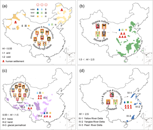
The different modes of population aggregation towards water bodies in particular areas lead to geographical diversity in not only ethnicity and language but also local culture. For example, Mode I is associated with the Western Regions Culture (Yu, 1981) and the Northeast Culture (Gao, 2012) (Figure 4a). Mode II relates to the dominant Chinese culture (Qian, 1994) (Figure 4b), the Huaxia Culture, introduced before the Zhou Dynasty (1046 bc–256 bc) by the Han ethnic group. Mode III is characterized by the Guan-Shan Culture (Loess Plateau), the Southwestern Ethnic Culture (Yunnan-Guizhou Plateau), and the Nomadic Culture (Tibet Plateau) (Figure 4c). The Guan-Shan Culture (J. C. Li et al., 2017) experienced its first golden age during the Zhou Dynasty. The Southwestern Ethnic Culture (Z. Q. Zhang, 2004) peaked during the Qin–Han Dynasties (221 bc–220). Meanwhile, the Nomadic Culture (J. F. Chen, 2014) experienced great prosperity during the Ming and Qing Dynasties (1368–1912). Mode IV is marked by the Qi-Lu Culture (Wang & Wang, 2008) (Yellow River Delta), the Wu-Yue Culture (Zhang, 1991) (Yangtze River Delta), and the Linnan Culture (Tan, 2002) (Pearl River Delta) (Figure 4d), the former being most prominent in the Han Dynasty and the latter two being the most prominent in the Tang-Song Dynasties (618–1279).
3.5 Evolution of cultural prosperity from the riverine perspective
As a consequence of human aggregation toward water, the populated areas with high habitability also achieve cultural prosperity. Here, we introduce a cultural prosperity index, given by the recorded number of litterateurs in a particular dynasty (DL, Method). Figure 5a shows the dynamic changes that occurred in the distribution of cultural centers in China over the past 2000 years. From the Zhou dynasty to the Tang dynasty (618–907), the majority of litterateurs resided in the most prosperous provinces of North China, primarily along the middle and lower reaches of the Yellow River. In the South Song Dynasty (1127–1279), the cultural center of China had transferred to South China, with litterateurs attracted towards the middle and lower reaches of the Yangtze River, and rivers in Zhejiang and Fujian provinces. In the Qing dynasty, culture throughout China approached maturity, with the cultural prosperity index DL progressively increasing from the inland to the east coastal areas, peaking in Jiangsu (481 Persons), Zhejiang (411 Persons), and Jiangxi (116 Persons) Province.
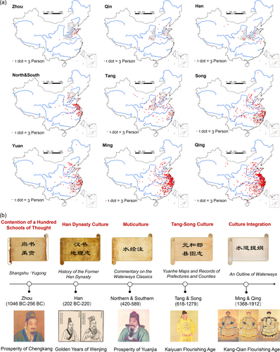
Benefiting from cultural prosperity, numerous rivers were named accordingly in terms of the geographic environment of regions flowing through, as well as local cultural characteristics and language habits. The cultural brand of human–river relations has been partially condensed in the river chorography through a series of milestone works (Figure 5b): The Chinese Classics (Yugong) (Legge, 2000) during the Warring States Period (475 bc–221 bc), Geographical Records in the History of the Han Dynasty (Dubs, 1938) in the Han Dynasty (202–220), Commentary on the Waterways Classics (D. Y. Li, 1894) in the Northern Wei Dynasty (515–527), Yuanhe Records of Prefectures and Counties (J. P. Li, 1983) in the Tang Dynasty (813), An Outline of Waterways (Z. N. Qi, 1878) in the Qing dynasty, and more recently, the Encyclopedia of Rivers and Lakes (Editorial Committee of Encyclopedia of Rivers and Lakes in China, 2014). In addition, historic river regulation strategies and grand hydraulic engineering works (e.g., the Lingqu Canal and Dujiangyan irrigation system) are also great legacy of Chinese human–river culture over the past 2000 years.
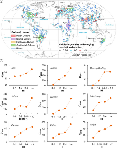
The human affinity for rivers and cultural prosperity along rivers is not limited to the national scales. On the global scale, a great number of rural settlements are clustered near the tributaries, and middle-large sized cities (each of population >0.5 million Persons) are distributed along the mainstream rivers stretching to estuarine areas (Figure 6). It seems that population density (D2015, Person km−2) increases with increasing HI in most great river basins worldwide (Figure 6), though exceptions do exist in high-latitude or arid regions. Areas with higher habitability (HI> 5) are frequently found in East Asia, South Asia, Western Europe, the eastern region of North America, and the southeastern region of South America, where the majority of the world's total population is settled (Zhang, 2013). Similarly, human aggregation catalyzed cultural prosperity in a variety of realms represented worldwide by Occidental Culture, Islamic Culture, Indian Culture, East Asian Culture, South-East Asian Culture, and Meso-African Culture (Deng, 2012).
4 CONCLUSIONS
We confirm the preferential orientation of human affinity for rivers through the linkage between natural river density, human livability, population density, and cultural prosperity in China. Compared with the distribution of population density derived from the demographic census in the Qing Dynasty (1776) under a near-natural state, we find that the relationship between population density and habitability, demarcated by the so-called “Hu Line”, generally holds to date (2019) despite long-term natural and anthropogenic changes in the past centuries. Moreover, self-similarity of the human–water co-occurrence relationship exists over sub-basins at varying stream-orders in river networks. We further extend human-water linkage to humanistic perspectives and interpret cultural prosperity and clusters of ethnicity under four representative modes of human aggregation towards rivers, including the splendid Chinese cultures developed in the arid (desert) areas, the alluvial plains, the plateaus, and the coastlands across the whole country. This study also highlights the importance of human–water harmony for historical, socioeconomic and cultural developments in global river ecosystems.
ACKNOWLEDGMENTS
The authors are grateful to the National Natural Science Foundation of China (Nos. 52109075 and 51721006).
ETHICS STATEMENT
The authors confirm that this article does not contain any studies with animal or human subjects.
Open Research
DATA AVAILABILITY STATEMENT
The data included in this study are available upon request from the corresponding author.


