Extreme Rainfall-Producing Echo Training Processes During Two Landfalling Typhoons in East China
Abstract
Echo training represents the primary mechanism through which rain bands precipitate extreme rainfall events. This study employed a combination of observational data and ERA5 reanalysis data to examine two instances of “echo training” that occurred following the landfall of typhoons Soudelor (2015, Process 1) and Fitow (2013, Process 2) in China. The findings indicate notable differences in the environmental background, characteristics, and the organization of convective rainbands between these two “echo training” processes. During Process 1, a well-developed convective system accompanied by a deeper boundary layer convergence between the cold pool and the easterly flow is observed. The presence of baroclinic structures permits the uplift of warm and humid air from the ocean that facilitated by the solenoidal term. During this period, the dispersion queues on both sides of the rainband contributed to the strengthening of convection and enabled convective cells to traverse the length of the rainband for an extended duration. In Process 2, the comparative wind between the easterly flow and the weak cold pool resulted in relatively shallow convergence, while the warm rain process dominated. The continuous generation of new cells occurred at the eastern boundary of the rainband, while dissipation occurred at the western boundary, resulting in persistent heavy rainfall for the covered area.
1. Introduction
The formation of quasistationary or stagnant mesoscale convective systems (MCSs) frequently results in the occurrence of heavy rainfall, which can subsequently lead to the development of floods and mudslides. This phenomenon represents a significant challenge for meteorological forecasting [1]. The “echo training” process [2], which is one of the primary aspects of convection responsible for extreme rainfall, refers to the quasistationary MCS associated with organized convective storms passing through one place successively [3–7]. Schumacher et al. [8–10] demonstrated that extreme rainfall-producing MCSs are predominantly organized in two modes: the back-building quasistationary mode and the training line adjoining stratiform mode.
To illustrate the back-building quasistationary mode “echo training” in China, the enhanced southwesterly jet in the afternoon brought sufficient water vapor to the windward side of the mountain, resulting in the lifting of new convective cells on the southwest side of the MCS [11]. Conversely, Peters and Schumacher [12] have shown that stratiform cloud merging convection is more likely to develop in the presence of downward the vertical wind shear over a cold pool. Additionally, research has also indicated that “echo training” typically occurs from afternoon to early evening, associated with warm and humid airflow and/or a low-level jet (LLJ) [13]. The deep southwesterly jet typically leads to highly consistent convective echo morphology and movement direction [14], with the deep convective cells that tilt downstream spaced along the convergence line [15]. The formation and maintenance of the “echo training” process is believed to be the result of neatly ordered meso- and micro-scale secondary vertical circulation [16].
The primary cause of extreme rainfall during landfalling typhoons is the “echo training” process in the spiral rainband [17–19]. This can be attributed to the convergence of mesoscale disturbances (or disturbance vortices) along coastal regions, which creates optimal conditions for convection formation and development within the typhoon rainband [20]. Recent case studies have been conducted to analyze the morphological characteristics of the typhoon “echo training” effect. For instance, the alterations in cloud condensation nuclei (CCN) concentration markedly influence the timing of storms, the frequency, spatial, and temporal distributions of precipitation, as well as the cloud base and top heights for the deep wet convective system [21]. However, the general and differentiated characteristics of meso- and micro-scale structures of the “echo training” effect in landfalling typhoons remain unclear.
In this regard, both Typhoon Soudelor (2015, Process 1) and Typhoon Fitow (2013, Process 2) exhibited the typical “echo training” process after making landfall, leading to extreme rainfall in the coastal region of Zhejiang province in China. To date, effective forecasting methods for the development and maintenance of such linear mesoscale convective rainbands are absent, and further investigation is recommended. Hence, this study investigates the organization and maintenance of these two “echo training” processes during landfalling typhoons in China with multiple datasets. We believe the findings will enhance our basic knowledge and skill in nowcasting.
2. Materials and Methods
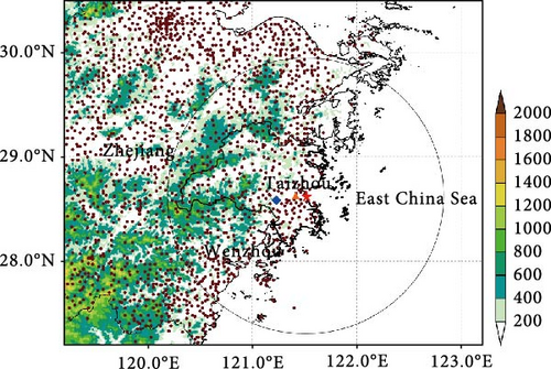
The study employs the tropical cyclones best track dataset for the Western North Pacific compiled by the Shanghai Typhoon Institute of China Meteorological Administration and ERA5 (the fifth generation ECMWF reanalysis for the global climate and weather) hourly global reanalysis data, with a spatial resolution of 0.25° × 0.25°, to examine large-scale circulations. Surface observations conducted over East China are used to investigate the spatial distribution of precipitation, temperature, and wind. Furthermore, convective organization modes are examined using S-band Doppler radar situated in Taizhou (Figure 1). The S-band radar implements the VCP21 scanning strategy, which performs a volumetric scan at nine elevations, including 0.58, 1.58, 2.48, 3.48, 4.38, 6.08, 9.98, 14.68, and 19.58, every 6 min. Moreover, three-dimensional 72-h backward trajectories are calculated utilizing the NCEP Global Data Assimilation System (GDAS) 6-h model analyses and the NOAA Hybrid Single-Particle Lagrangian Integrated Trajectory (HYSPLIT) model.
3. Results
3.1. Event Overview
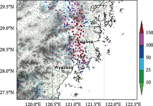
Typhoon Soudelor (2015) made landfall in Putian City, Fujian province at 1400 UTC on August 8, 2015, as a severe tropical typhoon (Table 1). The spiral rainband, distributed in a southeast-to-northwest direction, remained stationary at the northeast quadrant of the typhoon from east Wenzhou to Taizhou and the Siming Mountains. This phenomenon, as referred to the “echo training” feature, persisted for ~11 h. During this period, over 108 meteorological stations in Eastern Zhejiang province recorded accumulated rainfall exceeding 100 mm. The rainfall center manifested in Taizhou City, where the total rainfall exceeded 300 mm, and the highest 1-h (3-h) rainfall was 84.9 mm and 205.9 mm, respectively (Figure 2a).

| Number | TC name | Maximum wind speed during landfall (m s−1) | Landing area | “Echo training” periods (UTC) | Maximum accumulated rainfall (mm) |
|---|---|---|---|---|---|
| 1 | Souldelor (2015) | 30 |
|
07 : 00–18 : 00, August 9 | 313.3 |
| 2 | Fitow (2013) | 42 |
|
12 : 00, October 7−00 : 00, October 8 | 252.0 |
Typhoon Fitow (2013) made landfall in Fuding City, Fujian province, as a severe typhoon at 1700 on October 6, 2013. Concurrently, Typhoon Danas (2013) reached the eastern East China Sea. The linear mesoscale convective rainband between these two typhoons exhibited a strengthening trend after making landfall, resulting in persistent rainfall for ~12 h. The rainfall amounts at 117 stations exceeded 100 mm, with Taizhou experiencing the highest amount of 252.0 mm (Figure 2b).
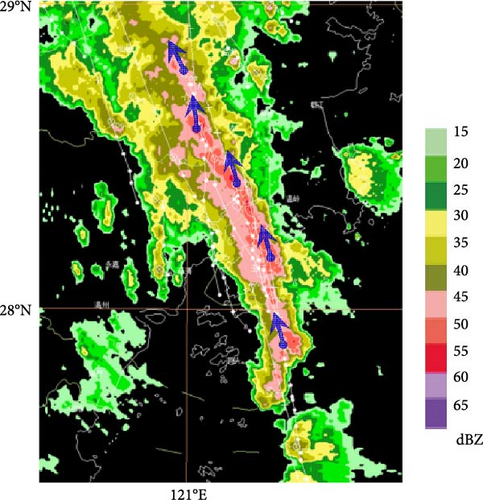
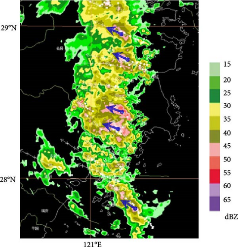
Although both “echo training” processes have produced extreme rainfall in East Zhejiang, there were notable differences in the organizational and developmental modes between them. Figure 3 shows the distribution of composite reflectivity and the direction of convection cell movement during the two processes. During Process 1, the convective rainband exhibited an SSE‒NNW trend of movement and was comprised of convective cells arranged in rows, with new convective cell motion parallel to the rainband. In contrast, during Process 2, the convective rainband exhibited an south–north trend as new convective cells merged into the eastern boundary of the rainband. The moving direction of the convective cells was nearly perpendicular to the stagnant rainband.
3.2. Comparison of Largescale Circulations and Synoptic Conditions
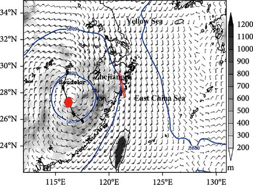
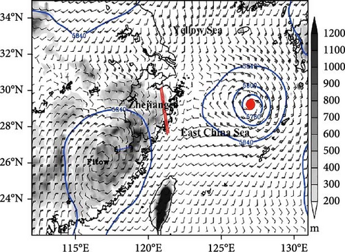
Figure 4 illustrates that the long axis of the “echo training” rainbands was approximately aligned with the ambient 500 hPa wind. The rainband of Process 1 developed within the expansive southerly flow situated between the 580 isobar of Typhoon Soudelor and the 588 isobar of the subtropical high. The wind speed over the area of extreme rainfall reached 22 m s−1. In contrast, the rainband during Process 2 was located between Typhoon Fitow and Typhoon Danas, with a relatively weak 500 hPa wind (ranging from 4 to 6 m s−1).
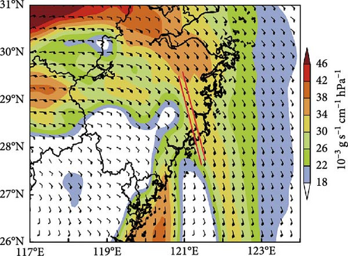
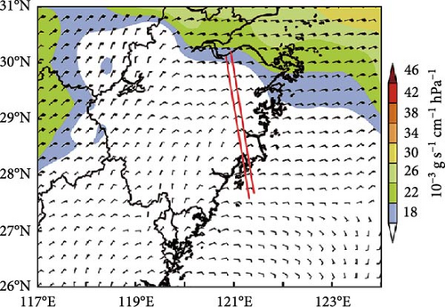
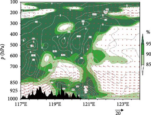
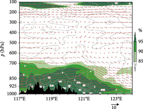
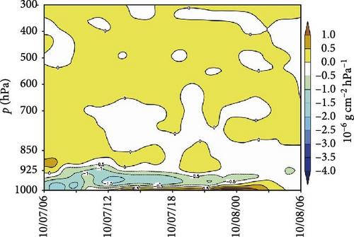
Additionally, discrepancies are observed in the water vapor transport pathway (Figure 5a,b). The strong water vapor flux at low latitudes reaches ~28 × 10−3 g s−1 cm−1 hPa−1 during Process 1, while the westward transport of moisture was lower than 20 × 10−3 g s−1 cm−1 hPa−1 during Process 2. However, the uplift and condensation of water vapor during these two processes occurred between the coastline and the windward slope of inland hills (Figure 5c,d). Meanwhile, the convergence of the water vapor flux during both processes was concentrated in the boundary layer below 925 hPa, with the maximum value exceeding 3.0 × 10⁻⁶ g cm−2 hPa−1 for Process 1 and 1.5 × 10⁻⁶ g cm−2 hPa−1 for Process 2, respectively (Figure 5e,f).

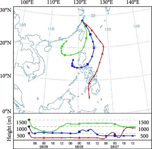
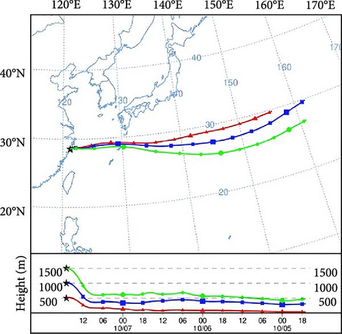
The 72-h backward trajectory (every 6-h) of water vapor sources during the two processes was further investigated using Lagrange tracking with the HYSPLIT4.8 model (Figure 6). The initial altitudes were 500 m, 1000 m, and 1500 m, respectively. As shown in Figure 6a, the water vapor in Process 1 originated from the South China Sea and the East Philippine Ocean, whereas that of Process 2 was mostly transported from the northwest Pacific Ocean.
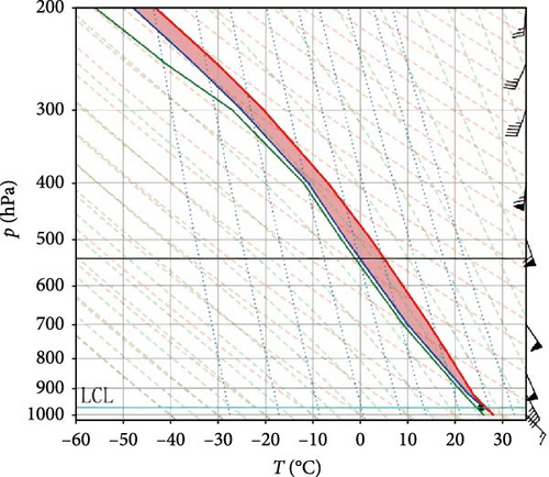
The soundings observed at Hongjia station indicated the presence of a conditionally unstable boundary during the two processes (Figure 7). In particular, the troposphere was nearly fully saturated during Process 1. The southeasterly jet extended from 925–500 hPa, with wind speeds exceeding 20 m s−1 between 850 and 400 hPa. The wind speed difference between the ground and 850 hPa was 12 m s−1, indicating substantial vertical wind shear during this process. Moreover, the convective available potential energy (CAPE) value was 1698 J kg−1, with a negligible CIN (8.4 J kg−1). In Process 2, the near-saturated layer was thinner (below 600 hPa), and the difference between temperature and dew point exceeded 20 K above 600 hPa. The wind speed below 850 hPa did not surpass 8 m s−1, with a moderate vertical wind shear between the ground level and 700 hPa. In this instance, the CAPE was 742 J kg−1.

3.3. Comparison of Meso- and Micro-Scales Thermal and Dynamical Characteristics
With regard to Process 1, Typhoon Soudelor resulted in rainfall over 100 mm within a 24-h period in the hilly areas situated to the west of 121.2°E. A cold pool was formed in this area, with surface temperatures remaining below 26°C. In contrast, surface temperatures to the east of 121.2°E increased to ~30°C due to the sustained influence of warm and moist air from the southeast. The temperature distribution indicates the emergence of a mesoscale temperature front zone situated over the cold pool region (Figure 8a). The scattered weak convection exhibited gradual linear organization characteristics, culminating in the formation of a linear mesoscale rainband trending in a southeast–northwest direction.
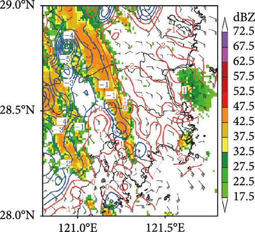
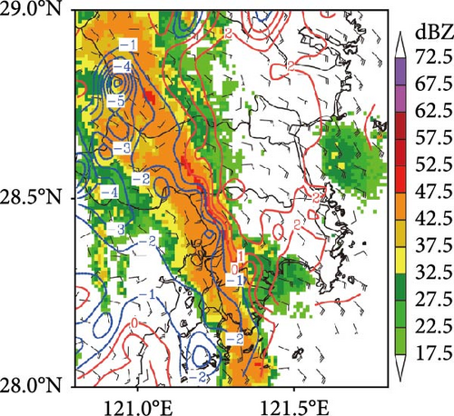
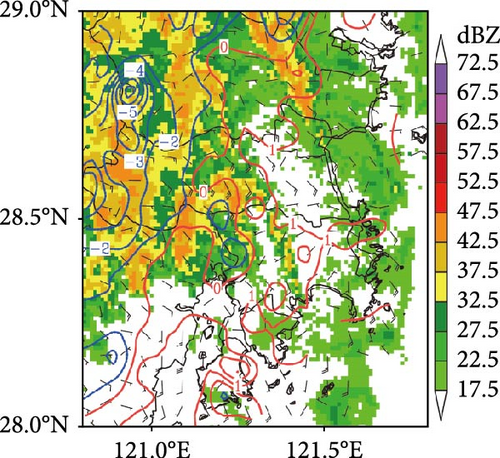
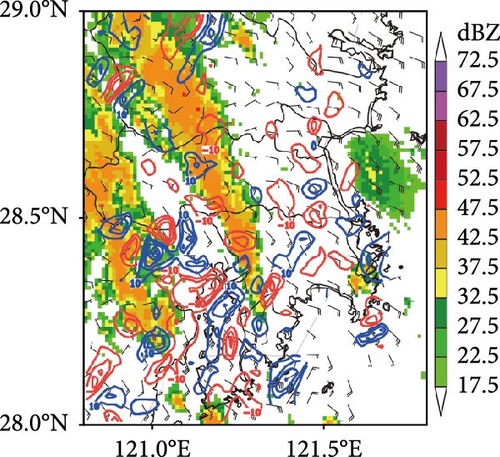
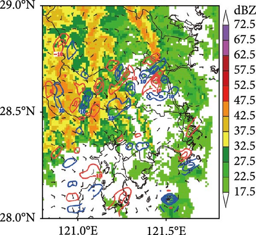
Subsequently, the mesoscale frontal zone was quasistationary and the temperature anomalies near the surface intensified (Figure 8b). The cold pool rapidly intensified as the temperature differential between the two flanks of the convective rainband reached 4°C. The southeasterly flow in the coastal region reached 15.6 ms−1. Consequently, a meso-γ scale convergence center was formed at the east edge of the rainfall area (Figure 8e), exhibiting a convergence rate in excess of 10 × 10−4 s−1. The rainband was well-organized to form an “echo training” process. Convective cells with reflectivity factors exceeding 50 dBZ proceeded in a northward in sequence, resulting in heavy rainfall exceeding 200 mm in Taizhou City. By 1800 UTC, the linear structure of the mesoscale rainband had dissipated (Figure 8c).
The aforementioned observations illustrate that the interaction between the southeasterly flow and the inland cold pool (caused by prolonged heavy rainfall) is conducive to the formation of a mesoscale front zone. This further promotes the lifting of warm and moist air by the solenoidal term. The positive and negative divergence pairs generated by lateral friction under the hilly area of Eastern Zhejiang serve to reinforce the organization of the convective rainband. In this regard, the southeasterly jet represents a fundamental condition for the formation of the mesoscale frontal zone and convergence.
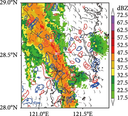
For Process 2, the surface temperature in the coastal region of Zhejiang increased to 28°C−30°C, coinciding with a cessation of rainfall as Typhoon Fitow weakened. However, the hilly area (west of 121.3°E) experienced rainfall for approximately 3 h longer than the surrounding regions, and the near-surface temperature remained at around 24°C throughout this period. From 1100 UTC, scattered weak cells over the sea approached the land amidst the strong easterly flow. Following the landing, the scope and intensity of convection developed gradually to form an south–north stripe rainband (Figure 9a). The rainband was located in a coastal area where the disturbance temperature is higher, with a meso-γ scale convergence center was present to the east of the rainband (Figure 9d).
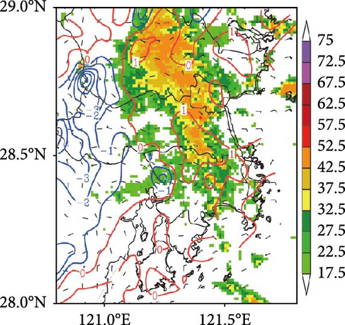
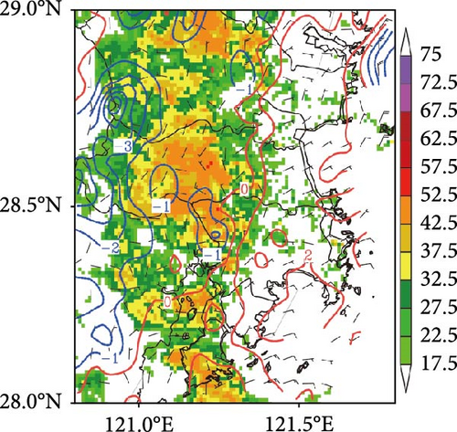
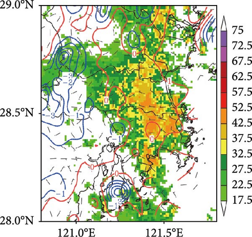
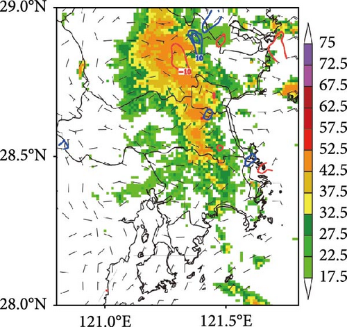
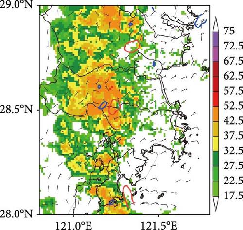
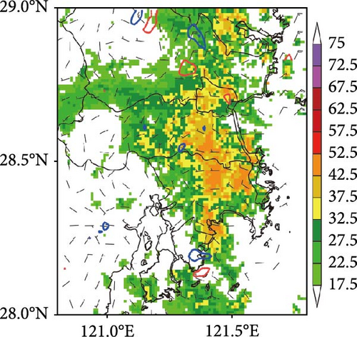
While the rainband remained in a quasistationary state with a relatively weak easterly air flow (6 m s−1) in the eastern sector, two meso-γ scale convergence centers have developed in the rainband (Figure 9e), with a temperature anomaly of 2°C (Figure 9b). The surface convergence and mesoscale barotropism exhibited slight enhancement, though not to the same degree as in Process 1. Subsequently, the rainband retreated to the east of 121.3°E, accompanied by a reduction of convergence and temperature anomalies (Figure 9c–f). In general, Process 2 indicates that persistent rainfall can occur in the absence of a strong mesoscale barocline and convergence, due to the coordination between a continuously weak easterly flow and a weak but stagnant cold pool, resulting in strong and continuous rainfall.
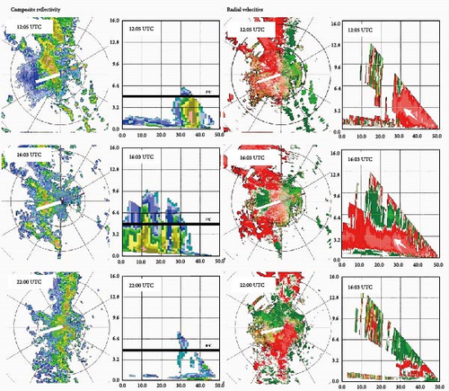
Previous research suggests that the conjunction of LLJ with a warm tongue would augment the θse at lower levels and curtail the convection inhibition energy, thereby creating a conducive milieu for the genesis and evolution of convection [22]. The VWP production of Doppler radar is an effective method for accurately identifying the wind field over the radar coverage area [23]. Here, the vertical structure of convection during the two processes was compared using radar reflectivity factor, radial velocity structure, and VWP products (Figures 10 and 11).
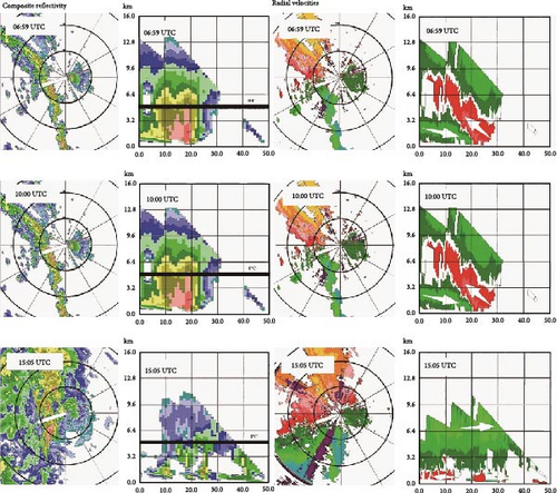
At 06 : 59 UTC on August 9, 2015, the southeasterly wind was dominated below 5 km height, with a 20 m s−1 jet observed at 1.2–3.7 km height. The 30 (40) dBZ echo top exceeded 5 (7) km in altitude, indicative of the involvement of ice-phase processes. At about 10 : 00 UTC, the southeasterly jet (over 20 m s−1) expanded upwards to 6.1 km, in conjunction with the southwesterly flow of the cold pool, forming a deep convergence zone that extended from the ground to ~5 km in height. In these circumstances, the maximum reflectivity factor increased rapidly to 55 dBZ at 1.5–2 km. This low centroid and high-intensity feature was conducive to the formation of heavy rainfall [24]. At 18 : 05 UTC, the wind direction at 5 km altitude changed from south to southwest while the rainband dissipated.
During Process 2, a deep ESE air flow (4–8 m s−1) occurred at ~5.5 km above the coastal region at 1205 UTC on October 7, 2013. Figure 11 shows that the 30 dBZ echo top can reach as high as 5 km, while the echo centroid over 45 dBZ was located at a height of 1–2 km, implying that warm rain process are dominant in the formation of heavy rainfall. Between 1600 and 1700 UTC, a nearly 50 km long north–south convergence zone was formed below 1.5 km altitude. The 30 dBZ echo top was mainly distributed at elevations below 3.2 km. The comparative wind speed on both sides of the convergence zone (ranging from 5 to 10 m s−1) resulted in stagnant convergence and persistent rainfall in that area. After 2100 UTC, the ambient wind changed to southwest at 3.4 km altitude and to northwest near the surface, causing the dissipation of the convergent flow and the eastward retreat of the rainband. The analysis indicates that the convergence of the westerly wind from the cold pool and the easterly wind from the open ocean represents a pivotal factor in the genesis and sustenance of the mesoscale convective typhoon rainband.
4. Conclusions
Both Typhoon Soudelor (2015) and Fitow (2013) resulted in extreme rainfall in Taizhou, Zhejiang province, in association with an “echo training” process following their landfall in East China. However, the two analogous linear mesoscale convective rainbands occurred in disparate environmental contexts. In light of the aforementioned findings, it can be posited that the timing and location of the observed “echo training” phenomenon are contingent upon the angle between the mesoscale front (or shear line) and the long axis of the rainband, irrespective of the direction of convective cell movement. The quasistationary mesoscale front zone, formed by the interaction between the cold pool and the warm and humid sea breeze, serves as a continuous stimulus for the generation of new convective cells. This mechanism is of particular significance in the context of the stagnation of convective rainbands, which are known to produce persistent heavy rainfall.
Specifically, during Typhoon Soudelor, a deep boundary layer convergence occurred between the cold pool and the easterly flow, which initiated convective cells and strengthened the organization of convection. This enabled convective cells to migrate along the long axis of the rainband, thereby facilitating the formation of the back-building quasistationary “echo training” process (Figure 12a). In contrast, during Typhoon Fitow, new convective cells were generated at the eastern boundary due to relatively shallow convergence under a weak cold pool. These cells then propagated perpendicular to the convective line, resulting in persistent heavy rainfall in a training line-adjoining stratiform mode (Figure 12b).


As we have comprehensively demonstrated the synoptic conditions, and meso- and micro-scale thermal and dynamical characteristics of two different modes of extreme rainfall-producing “echo training” processes caused by landfalling typhoons, the results of this study will inform the development of more efficient strategies and models for disaster prevention and mitigation by forecasters and researchers. However, given that only two cases were observed despite their obvious differences, further observations are required to enhance the findings and refine the conceptual model (Figure 12). We are currently engaged in relevant observation and analysis.
Conflicts of Interest
The authors declare no conflicts of interest.
Author Contributions
Conceptualization: Zhimei Weng, Sinan Gu, and Wen Gu. Methodology: Zhimei Weng, Kai Wang, and Li Gao. Software: Zhimei Weng and Yecheng Feng. Validation: Yecheng Feng and Boyan Lu. All authors have read and agreed to the published version of the manuscript.
Funding
This research was funded by the Taizhou Science and Technology Project of Zhejiang (grant no. 1901gy17), the joint funds of the Zhejiang Provincial Natural Science Foundation of China (grant no. LZJMZ23D050004), Shanghai Typhoon Research Foundation of China (grant no. TFJJ202410), and Zhejiang Meteorological Science and Technology Project (2023YB25).
Acknowledgments
The authors thank Professor Yu Xiaoding from China Meteorological Administration Training Center and Doctor Wen Long from Beijing University for their suggestions on the optimization of the article.
Open Research
Data Availability Statement
The data used to support the findings of this study are available upon request from the author.


