[Retracted] Self-Driving Tour Travel Route Planning Model Construction Using Recurrent Neural Network
Abstract
With the continuing increase of people’s living standards, tourism has now become the primary mode of holiday and leisure activity. Scientific and reasonable route planning can best meet people’s essential needs, provide detailed planning in terms of travel time and cost, resolve the impact of various external factors, and realize the complementary benefits of scenic tourism while ensuring that each factor configuration is optimized. External factors such as trip time, cost, travel date, and transport mode all have an impact on route planning. In order to develop a mathematical model and gather other information, it is frequently essential to determine two or more of these influencing elements. The ideal plan for the influencing elements is to first develop an optimal self-driving trip route that meets all of the requirements. This strategy is becoming increasingly popular among the general public, and it focuses on how to spend the least amount of money in order to visit more tourist attractions, construct the most reasonable routes, and provide circumstances for tourists to save time and money. The purpose of this study is to examine the topic of self-driving travel route planning and to suggest the creation of a route planning model. In this paper, a self-driving journey route planning model is built using a recurrent neural network model. The driving route is designed with a high-speed priority strategy, and the travel route selection problem takes into account the consumption condition as well as the quantity of scenic sites. The developed model is used to optimize self-driving trip routes, and the results are promising.
1. Introduction
Tourism has now become the primary mode of recreation and leisure, owing to the continuous improvement of people’s living standards. Self-drive tours are reasonably priced. The departure time, attraction time, and rest time can all be customized. You can choose where you want to live and what standards you want when it comes to living arrangements. What climate to eat in, where to eat, and what to eat can all be customized. Food, clothing, housing, and transportation, as well as group tours and even going to the bathroom, are all planned by themselves. Because the self-driving tour necessitates you driving and organizing everything yourself, you may encounter a variety of scenery along the way. You can either immediately stop and enjoy it or continue on your way. You can bring more items on a self-driving tour. You can travel by car or in a group. It will be very heavy and inconvenient to move around if you bring too many items. The majority of self-driving cars, in general, are not alone. On the other hand, the people in the car are either family or friends. They are at ease as they converse and laugh along the way. Unlike a tour group, they do not know each other and have nothing to say.
As people’s living standards rise, traveling has become a popular leisure activity for them to partake in during their vacations. And now, when people go on vacation, many of them prefer to travel by car. Self-driving travel has many advantages over traditional group travel. To begin with, self-driving tours are unquestionably more convenient than group tours. After all, when you go on a group tour, almost all of the itineraries are limited, and it is even specific as to which time period you should go to which scenic spot, and when the time period will begin. The rest is generally unsatisfactory. When traveling in a group, it is common for the tour guide to force you to shop, resulting in unnecessary consumption. Of course, you cannot buy it, but that leads to arguments and ruins the travel mood. This phenomenon will not exist if you are traveling by car. When compared to group tours, self-driving tours can actually reduce consumption significantly. You can consider more affordable and suitable plans for yourself, prepare everything for the trip, and leave yourself a more perfect journey in every way.
Of course, self-driving travel is not perfect, and it has flaws of its own. To begin with, having a car is a requirement for self-driving travel. Despite the fact that people’s lives are improving, many people in their late 1990s and early 2000s still do not own a car. Even if they do not travel in a group, they can only take a popular Tool travel option. Furthermore, when compared to group tours, self-driving tours to an unfamiliar location are more likely to be deceived and cause problems. If the road conditions are unfamiliar, time may be lost, as well as a safety accident. Furthermore, driver fatigue and car breakdowns in the middle of the road are unavoidable issues. Even self-driving tours, however, have a number of issues. However, in general, its benefits outweigh its drawbacks. Every year during the holidays, people with the means will generally choose to travel by car in order to have a more enjoyable travel experience. This, combined with the free holiday policy, makes self-driving ideal.
Scientific and reasonable route planning can meet people’s necessary needs to the greatest extent possible, make detailed planning in terms of travel time and travel cost, resolve the impact of various external factors, and realize the complementary benefits of scenic tourism while ensuring that each factor is configured optimally. It is necessary to build a scientific route planning model, whether from the perspective of tourists’ needs or from the perspective of various external factors that affect the efficiency and quality of tourism. Self-driving tours are becoming increasingly popular as a form of tourism, and it is the goal that people pursue to study and spend the least amount of money to visit as many scenic spots as possible. Designing a reasonable travel route can save tourists time and money while also providing a scientific and effective reference for their trip.
2. Related Information
2.1. Problems Existing in Self-Driving Tours
A self-driving tourist must plan a trip based on the list of 5A scenic spots published by my country’s Tourism Administration. The tourist is expected to travel to 220 5A-level scenic spots in my country over the course of ten years, and the travel itinerary must meet the following requirements. Tourists are only allowed to travel for 30 days per year, and they can only take two trips per year. The travel time is limited to 15 days per visit, and the 5A-level scenic spot is limited to one day per visit. The self-driving tour is only available from 9 a.m. to 7 p.m. every day, with a maximum driving time of 6 hours. A full-day tour must guarantee a driving time of no more than 2.5 hours, and a half-day tour must guarantee a driving time of no more than 4 hours. On the highway, the average tourist speed is around 48 kilometers per hour, while the highway speed is around 95 kilometers per hour. Tourists typically spend one day in each province’s capital, with scenic spots open from 9 a.m. to 5 p.m.
2.2. Solution Strategy
The high-speed route is prioritized in the driving route design. Using 250 5A scenic spots in my country as points, the national optimal tourism design plan is created using an improved circle algorithm and Matlab programming. To improve the scientificity of the plan, the road route planning graph is regarded as a graph in graph theory, the city is regarded as a node, and the distance between the nodes is regarded as a coefficient to compile a matrix relative to the graph and then calculate the minimum distance from the starting point to the scenic spot. The data collection is clustered from scenic spot to scenic spot, and the cluster analysis method is used to analyze and group 250 scenic spots at the same time. Cluster analysis is performed using the classical cluster analysis algorithm [1–3] in conjunction with its geographical location. The majority of tourist attractions are combined using the clustering method, and then the scenic spots are visited in units. The ant colony algorithm [4, 5] can compute the time needed for the tour as well as the travel time of self-driving traffic. As a result, the planning objective can calculate the shortest route by calculating the minimum distance between any two junctions. When the intermediate nodes are removed and other scenic locations are to be visited directly, a direct passage can be provided, making the problem more concise. The Floyd algorithm [1, 6] can be used to determine the shortest distance between scenic locations. It is a symmetric matrix, and the element unit in the matrix is hours, as determined by the previous consistent conditions. The total time required to travel to the scenic spot to be visited can be calculated by programming the ant algorithm. Then, add up the time it takes to visit each scenic spot to get the total time spent visiting all scenic spots.
2.3. Self-Driving Tour Planning
The following is a typical self-driving tour itinerary: Determine when you will be traveling back and forth for a few days first. The amount of time available for a trip is limited; no matter how far you travel, you must return to the starting point, so time limits how far you can travel to the destination. To choose the farthest destination, the second step is to calculate a reasonable round-trip mileage based on the time available. You cannot just go out and drive; you have to stop and take in the sights and smells of life. While the most beautiful scenery can be found on the road, good scenery is worth stopping for, quietly enjoying, and immersing yourself in. After all, there are a lot of them. The area must be traversed on foot or over mountains and mountains, which is time-consuming and exhausting, and sufficient rest time must be provided. As a result, the distance between the starting point and the farthest destination should be reasonable. The third step is to use mobile phone navigation to determine the preliminary round-trip route, which is then fine-tuned based on the waypoint’s surroundings. Simultaneously, focus on the round-trip as much as possible without going back, preferably in a circle. To ensure that the journey is not a monotonous hurry, I choose a place worth visiting and stay for one night in a place that can be easily reached in one day without stopping on the way. The fourth step is to plan the daily stay and accommodation points based on the general route map. If the stop point is not worth playing, use it as a rest point instead. If it is worthwhile to play, you can stay for a day and a half, run for half a day, and play for half a day. If it is too early to play for the day, try to get to the next destination as soon as possible; there is no need to stay another night unless the night here is appealing. The fifth step is to decide which attractions or activities will be arranged based on the stop point. Do not be greedy for too many scenic spots; instead, go to one of the same scenic spots; there is no need to check in one at a time. Sixth, consider whether the daily itinerary, including the destination, driving mileage, main attractions, play time, and so on, is balanced and reasonable as a whole. If there are no issues, set the self-driving route and itinerary in stone. My strategy is to book hotels and plane tickets first, and then cancel them for free, because the biggest benefit of self-driving travel is the ability to simply leave. Time is limited; rather than overusing it, insist on being uncompromising. Typically, the factors listed above must be considered when traveling by car. This method consumes the organizer’s energy and necessitates a significant amount of time spent researching routes, comparing costs, and so on. An intelligent self-driving travel planning method that serves the masses must be proposed urgently.
3. Travel Route Planning Model for Self-Driving Tour Based on Recurrent Neural Network
3.1. Recurrent Neural Network Model
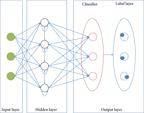
The recurrent neural network (RNN) evolved from the Hopfield network proposed by Saratha Sathasivam in 1982, but it was not widely used at the time due to implementation difficulties. The deep expression ability of recurrent neural networks to mine time series information and semantic information in data was not fully utilized until more effective recurrent neural network structures, such as deep recurrent neural network [7–9], were proposed. RNN is widely used in sequence data processing [10, 11], speech recognition [12, 13], image processing [14–17], and other scenarios. RNN is primarily a three-layer architecture, with input, hidden, and output layers. Figure 1 depicts the basic structure of an RNN. The input layer is one of them, and it is used to input the data to be processed. The model learns and optimizes the parameters in the hidden layer. The output layer includes the classifier and the label layer. The Softmax layer is another name for the classifier. This layer classifies and estimates the hidden layer’s output and chooses the label with the highest probability.
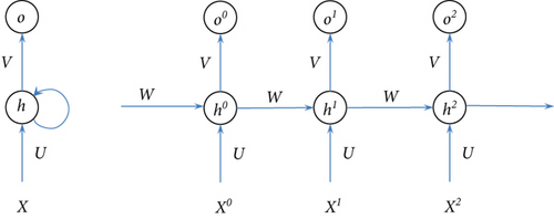
There is a type of recurrent neural network known as the long short-term memory (LSTM). LSTM’s improved structure allows information to selectively change the state of each instant in the recurrent neural network using some gate structures [18].
An artificial intelligence learning system [19] built by Google, Tensorflow, powers this experiment on a Windows PC using the Spyder and Python programming environments. The neural network’s training is completely undetectable. TensorFlow provides a visualization tool, TensorBoard, to make the structure and parameter modification feedback of the neural network clearer. TensorBoard is a useful tool for monitoring the performance of TensorFlow. Table 1 shows the starting parameters used in this study. There are around 3000 model iterations before the accuracy and loss function are stabilized. During model training, the batch size variable contains a high number of training examples. A huge amount of computer memory will be utilized during network backpropagation if all training samples are directly inserted into the model for training at once. The training samples are therefore batch-trained. There are approximately two times as many batches as there are people in the world. With the experiment’s number of training samples and the number of training data samples, the total number of training data samples is 32. This experiment uses a value of 32 for the RNN hidden size variable, which is set to 1 while training the network with this value. RNN_ hidden_ layers can be increased in order to reduce model error, but this increases network complexity and training costs, as well as the risk of overfitting. It is set to 2 layers by default. To determine learning rate, the exponential decay approach is used. Learning rate can be set at a bigger value in the exponential decay approach, which can be reduced until it reaches an optimal value over a period of time. n classes is a variable that specifies the number of classes. The samples are sorted into two categories for the experiment. Loss functions are steady at approximately 0.24, and the final model accuracy is around 0.92. Listed in Table 1 are the parameters used to train the model.
| Variable | Variable meaning | Value |
|---|---|---|
| epochs | Number of training iterations | 3000 |
| batch_size | Number of training data samples in a single session | 32 |
| RNN_hidden_size | Number of hidden layer nodes | 2 |
| RNN_hidden_layers | The number of hidden layers of the neural network | 2 |
| Learning_rate | Initial learning rate | 0.001 |
| n_class | Number of categories | 2 |
| Features_number | Number of features | 13 |
4. Experiment
4.1. Driving Route Modeling
The design of the traffic route is based on the high-speed prioritization technique. The best tourist route in the country is constructed using the improved circle algorithm, which is based on 300 5A-level beautiful places throughout the country as nodes. This demonstrates the rationale and practicability of the improved circle algorithm. According to graph theory, cities are equivalent to nodes on a road map, and the sparse matrix corresponding to the road map has the distance between nodes written in terms of the distance between nodes as a coefficient. Then, in order to arrange a specific trip itinerary, determine the shortest distance between the starting point and the scenic location in question. As part of the ant colony algorithm’s data preprocessing step, the fuzzy C-means clustering (FCM) method is utilized to arrange 300 tourist picturesque places into groups of similarity. Scenic locations are categorized as units, and their longitude and latitude are taken into consideration, as well as the FCM algorithm, which is utilized for clustering. Figure 3 depicts the outcomes of the study.
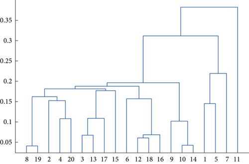
According to the clustering method, the majority of tourist attractions are consolidated into 12 scenic locations, which are then visited in the same manner as scenic spots. The ant colony method is capable of calculating the browsing time in the beginning, including the time spent on the tour in the scenic area as well as the time spent consuming traffic on the road. As a result, the planning goal is to find the shortest path between any two scenic spots. As a result, if one scenic spot in the middle is ignored and one wishes to visit another scenic spot, there can be hundreds of passages to make the problem more intuitive and simple, as can be seen in the example below. The RNN method is used to determine the shortest travel time between the two picturesque locations in question. A symmetric matrix with members in hours, according to the prior assumptions, is represented by the matrix. When the ant colony method is used to construct the software, it is possible to determine that all picturesque sites must be visited in the shortest amount of time possible while driving. When combined with the tour time at each picturesque location, you can estimate the total time required to see all of the scenic locations. Figure 4 depicts the exact principle in question.
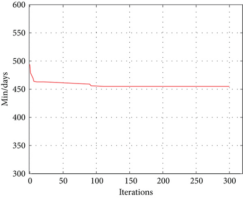
As can be seen on the diagram above, the shortest possible circumnavigation time is around 1 year and 98 days. Following cluster analysis, the total amount of time required to see all of the picturesque sites is a fixed value: 12 years and 10 days. The overall duration is made up mostly of the smallest number of tours and the shortest length of stay, which adds up to 13 years and 12 days. According to this figure, it would take a traveler at least 13 years to travel through all 300 5A picturesque locations.
4.2. Route Optimization Modeling
Tourists want to visit 300 5A scenic locations across the country within the next ten years, and they are looking for the best value as well as the best experience. This is an example of a route optimization problem. The solution can be summarized as follows: When the number of tourist attractions has been identified, create an optimal planning model, and plan a tourist route with the lowest possible cost as the goal when determining the best planning model. Assume that the total cost includes the cost of the lodging plus the cost of travel. Create a self-driving tour planning model with the help of the RNN model. Table 2 contains the information that was utilized to construct the model.
| No. | Departure | Place to stay | Accommodation fee/yuan | Toll/yuan | Travel time/h | Attractions | Browsing time/h |
|---|---|---|---|---|---|---|---|
| 1 | Hangzhou, Zhejiang | Beijing | 580 | 795 | 12.5 | Forbidden City | 2 |
| 2 | Nanjing, Jiangsu province | Beijing | 600 | 840 | 13.3 | Badaling Great Wall | 2 |
| 3 | Suzhou City, Jiangsu province | Nanjing, Jiangsu province | 600 | 135 | 2.3 | Zhongshan scenic area | 1 |
| 4 | Nanjing, Jiangsu province | Hangzhou, Zhejiang | 580 | 247 | 3 | West Lake | 1.5 |
| 5 | Hangzhou, Zhejiang | Shanghai | 650 | 175 | 1.8 | Safari | 2 |
| 6 | Zhoushan City, Zhejiang Province | Shaoxing City, Zhejiang Province | 460 | 154 | 1.4 | Lu Xun’s hometown Shenyuan scenic spot | 1 |
| 7 | Wuzhen, Zhejiang Province | Zhoushan City, Zhejiang Province | 460 | 290 | 3.2 | Zhoushan Putuo Mountain scenic area | 1.5 |
| 8 | Shanghai | Shanghai | 600 | 0 | 0 | Shanghai science center | 1.5 |
| 9 | Nanjing, Jiangsu province | Nanjing, Jiangsu province | 550 | 0 | 0 | Zhongshan cemetery scenic area | 1 |
| 10 | Suzhou City, Jiangsu province | Suzhou City, Jiangsu province | 550 | 0 | 0 | Humble Administrator’s garden | 0.5 |
| 11 | Nanjing, Jiangsu province | Huangshan City, Anhui Province | 480 | 780 | 4 | Huangshan scenic area | 2 |
| 12 | Jinhua City, Zhejiang Province | Kaihua County, Zhejiang Province | 320 | 248 | 2.8 | Kaihua root palace Buddhist cultural tourism zone | 0.5 |
| 13 | Hangzhou, Zhejiang | Xi’an, Shaanxi Province | 500 | 1430 | 14.1 | Qin Shi Huang terracotta warriors and horses Museum in Xi’an | 1.5 |
| 14 | Suzhou City, Jiangsu province | Guangzhou, Guangdong | 680 | 1580 | 16.4 | Guangzhou Changlong tourist resort | 2.5 |
| 15 | Hangzhou, Zhejiang | Aba prefecture, Sichuan Province | 580 | 2085 | 24.5 | Jiuzhaigou scenic spot | 2 |
Tourists can go from Xi’an to Hangzhou, then to Huzhou, then Jiaxing, Wuzhen, Zhoushan, Shaoxing, Jinhua, Kaihua County, Chun’an County, and Shanghai, as illustrated in Table 1. In the case of a family of three traveling together, the rental car charge is 300 yuan per day, which includes fuel and toll taxes. For accommodation in provincial capital cities, the cost is 200 yuan per person per day; for accommodation in prefectural level cities, the cost is 150 yuan; and for accommodation in county towns, the cost is 100 yuan. The combined fuel consumption of the expressway and toll fee is one yuan every kilometer traveled. The fuel consumption rate on regular roads is 0.6 yuan every kilometer traveled. Taking into consideration all other natural elements and unforeseen circumstances, the overall cost is comprised of the transportation costs, the lodging costs, and the cost of visiting the scenic location. The total of the three costs is 42510 + 81350 + 59231 yuan, for a total of 183091 yuan. The total cost of a trip for a family of four traveling the same route is the transportation cost plus the cost of lodging and the cost of sightseeing. The total of the three costs is 47548 + 92342 + 62184 yuan, which is 202074 yuan in total.
A family of three traveling together is assumed to be traveling the following route: Nanjing-Suzhou-Hangzhou-Jinhua-Shaoxing-Shanghai-Huangshan. The car rental fee is assumed to be 300 yuan per day (fuel and toll fees are calculated separately), and the accommodation in the provincial capital city is 200 yuan per person/150 yuan/day per person per day in prefecture-level cities and 100 y. For expressways with tolls, the fuel consumption is one yuan per kilometer traveled, while for conventional highways, the fuel consumption is six cents per kilometer traveled. Taking into consideration all other natural elements and unforeseen occurrences, the overall cost is comprised of the transportation cost, the lodging cost, and the cost of the beautiful site tour. The three types of expenses are broken down as follows: 28943 + 41326 + 40322 = 110591 yuan in total. If a family of four travels the same route, the total cost is comprised of the transportation cost, the hotel cost, and the cost of the beautiful location tour, all added together. The total amount of the three types of expenses is 30078 yuan + 43465 yuan + 43688 yuan = 11231 yuan.
A family of three traveling together is assumed to take the following route: Hangzhou - Jiaxing - Jinhua - Shaoxing - Nanjing - Suzhou - Xi’an. The car rental fee is assumed to be 300 yuan per day (fuel and toll fees are calculated separately), while the cost of accommodation in the provincial capital city is 200 yuan per person/150 yuan per person per day in prefecture-level cities and 100. For expressways with tolls, the fuel consumption is one yuan per kilometer traveled, while for conventional highways, the fuel consumption is six cents per kilometer traveled. Taking into consideration all other natural elements and unforeseen occurrences, the overall cost is comprised of the transportation cost, the lodging cost, and the cost of the beautiful site tour. The three types of expenses are denoted as 30217 + 41026 + 36521 = 107764 yuan in the breakdown. If a family of four travels the same route, the total cost is comprised of the transportation cost, the hotel cost, and the cost of the beautiful location tour, all added together. The total amount of the three types of expenses is 35228 yuan, 40632 yuan, and 39876 yuan, for a total of 115736 yuan.
5. Conclusion
To summarize, as people’s living conditions have improved, tourism has grown in popularity as a popular holiday leisure activity. When visiting beautiful places, especially on self-driving tours, people are often concerned about how long it will take them, what they will see, and how much it will cost. A comprehensive self-driving trip itinerary planning model can be created to serve as a specific reference for the advancement of self-driving travel and to compute the most efficient route. This study proposes the development of an RNN-based model for self-driving tour route planning. This sophisticated model-based route planning for self-driving tours saves both time and money. Because RNN is a deep learning method, there are several parameters in this model that must be checked and changed, resulting in a long training period for the model. We will try to find a solution to this conundrum in future research.
Conflicts of Interest
The author does not have any possible conflicts of interest.
Open Research
Data Availability
The data used to support the findings of this study are available from the corresponding author upon request.


