Rural Tourism Resource Research Based on Multisensor and Geographic Information Big Data
Abstract
With the continuous improvement of living standards, the rapid development of tourism, and increasing maturity of traveler behavior, tourism has become an essential part of people’s daily life. Also, in recent years, with the continued development of economic and global integration, coordinated development has become a global trend. After more than 30 years of development and exploration, rural tourism in China is increasingly diversified. The accelerated development of a new socialist countryside and the integrated development of urban and rural areas provide important options for urban residents to escape from their habitual environment and seek leisure, comfort, and relaxation. Meanwhile, rural tourism development is based on certain resources and has a great coupling relationship with China’s urban and rural development. As a result, rural tourism has long become a hot issue for academic research. However, with the continuous promotion of rural revitalization, rural tourism in China has presented some serious problems such as resource overdraft. These issues have caused serious harm to China’s rural tourism resources and cultural heritage. On this basis, it is necessary to view rural tourism development from the perspective of coordinated regional development. Specifically, rural tourism resources should be characterized through a method of character selection to sort out rural development paths. At the same time, the development of regional tourism linkages for villages with shared source markets, dense location distribution, and similar landscape resources can effectively avoid regional homogeneous competition, form complementary advantages, and achieve sustainable development of regional economy, culture, and society. In addition, with the continuous development of information technology and computer technology in recent years, the construction of digital countryside has been completed. In other words, the conditions are in place to establish a rural tourism resource information platform that combines tourism information database and geospatial framework. The establishment of rural tourism resources information system will meet the information requirements of tourists and tourism management departments and lay the foundation of information technology for the development of rural tourism. Therefore, this study combines multisensor and geographic information big data technology to explore rural tourism resources. After that, based on the analysis of the evaluation results, specific regional overall linkage development strategies are proposed in four aspects: coordinating regional resources, optimizing resource allocation, integrating spatial types, and establishing regional brands. This can provide an effective strategic support for the diversified development direction of rural tourism.
1. Introduction
As a new force in tourism, rural tourism has emerged as a dynamic force in the rapid urbanization of cities and towns [1]. With the penetration of foreign rural tourism ideas and the subjective demand of domestic rural tourism, rural tourism in China has developed significantly. With the continuous development of rural tourism, more and more stakeholders have started to pay attention to the past, present, and future of rural tourism [2–4]. Since 2005, there has been an explosion of research results related to rural tourism, and rural tourism has become a research hotspot in the tourism field. As a large agricultural country with a history of thousands of years of farming civilization, China has a vast territory and a large area [5]. However, due to differences in ethnicity, climate, and region, villages with diverse spatial forms, diverse cultural components, and distinctive regional characteristics have been formed over a long period of time. Villages are seeing economic and humanistic activities based on the natural geographic environment, and they are the units of settlements with regional characteristics formed by local residents during their long lives [6]. The village is not a stable entity, but a product of the interaction between human society and ecological environment over a long period of time [7]. The landscape resources are the most obvious and vivid potential development resources of villages, which are the basis for distinguishing from other regional characteristics and forming regional personality [8].
With the continuous promotion of rural construction under the rural revitalization strategy, rural tourism development has become a proven development method for rural conservation and development [9]. As shown in Figure 1, the scenery in rural tourism is quite great. However, while rural tourism development is vigorously advocated, the phenomenon of similar models and mechanical replication of mainstream development concepts is still common [10]. In this context, a series of development problems such as one-sided villages [11], environmental pollution [12, 13], and disorderly development [14] have emerged. These problems have caused great losses to many of China’s resource-rich and richly endowed villages. In addition, the rapid development of rural tourism has exacerbated the incongruous tendency to change the rural landscape while increasing economic income [15]. After all, landscape resources with local characteristics are the basic connotation of highlighting the characteristic appearance of the countryside. However, in the face of the gradual urbanization and commercialization of rural landscape, the disorderly use of rural landscape resources is the most urgent problem facing rural construction at present.

Rural landscape usually refers to the complex result of economic, social, natural, and human phenomena within a certain geographical area and is also subject to the constraints of both natural conditions and human activities. Due to the complex background of the meaning of both rural and landscape, scholars in different fields have different understanding of the concept of rural landscape [16]. From the perspective of geographical scope, rural landscape refers to the spatial landscape of human settlements and behavioral activities other than urban areas [17]. From the viewpoint of landscape composition, rural landscape is a landscape environment complex composed of rural settlement landscape, economic landscape, cultural landscape, and natural environment landscape [18]. In terms of landscape function, rural landscape has the function of providing agricultural products, maintaining ecological balance, and serving as a tourist resource [19]. What is more, from the viewpoint of landscape characteristics, rural landscape is different from urban landscape in terms of low interference, less destructive, and stronger natural attributes.
Although many scholars have studied rural tourism from different perspectives in recent years, there is still no clear and unified grounded theory on how to define the concept of rural tourism. Since rural tourism has similarities in sustainability to agritourism and ecotourism, and the diversity of tourism product development is increasing [20], as a result, the generalization of the concept of rural tourism is worsening, and scholars are often confused about the meaning of some rural tourism concepts. In addition, the government and the tourism industry are unable to formulate targeted policies and implement management practices [21]. These factors have greatly affected and hindered the rapid development of rural tourism [22]. In addition, the topic of rural tourism development has attracted the attention of scholars in recent years and is becoming a hot topic in international rural tourism research. In the early stages of research, the focus was more on government-related factors and rural tourism hardware facilities, making the scope of research on rural tourism development relatively narrow [23]. However, in recent years, with the widespread development of rural tourism activities, a large number of scholars have begun to conduct field research and analysis. Nevertheless, there are still many imperfections in the current research on the influencing factors of rural tourism development.
What is more, quantitative research has not been carried out well compared to the current extensive qualitative research. This has not only increased the ambiguity and uncertainty of the research on the impact factors of rural tourism development but also made it difficult to concisely represent and present the complex logical relationships among the impact factors [24]. As an example, the question of who has a greater influence on rural tourism development factors remains ambiguous. After all, it is difficult to quantify and present the results of qualitative research on the extent to which the influencing factors affect each other [25]. This situation suggests that there is still much room for research and much room for improvement in the academic field of impact factors in rural tourism development. The study of impact factors is the basis for the industry’s own improvement and policy formulation. As a result, there is a strong need to study the impact factors of rural tourism development based on quantitative methods.
Regional tourism linkage refers to the breaking of administrative boundaries of each tourist place within a certain geographical area. At the same time, according to the inherent correlation of tourism resources, interregional association and collaboration, with the power of regional tourism as a whole, participate in the competition and then realize the development process of common development of each tourist destination [26]. The development of tourism destinations in neighboring regions inevitably faces competition with each other, which in turn leads to the problem of common tourism products, mutual substitution, and lack of distinctive brand characteristics in each region. Regional tourism linkage is essentially a development model that enhances the attractiveness and competitiveness of regional tourism through interregional cooperation and collaboration, bringing into play the advantages of each resource and achieving complementary advantages [27].
The Central Plains has been the main body of traditional Chinese civilization since ancient times and is one of the poles of propagation and birthplace of China’s traditional civilization. The villages in close proximity to each other enjoy similar cultural and historical backgrounds due to their geographical distribution [28]. Faced with the opportunity of rural tourism development, the contradiction and conflict between the state of the heritage and the profound heritage can easily lead to vicious competition such as homogeneous development or IP competition. Regional tourism linkage is the practical part of regional linkage theory, which helps to drive regional development with tourism as the starting point, and is one of the models of regional linkage development [29]. In the context of new rural construction and the development of regional tourism linkage theory, many regions have begun to combine regional tourism linkage with rural planning practices. These initiatives are often able to maximize the development of landscape resources, maximize the value of resource utilization, and complement the advantages of the surrounding areas to achieve sustainable development [30].
Rural tourism development has become a hot topic in rural studies. Diversified ideas have emerged, but most of them remain in the microscopic perspective of single analysis and isolated development [31]. While regional tourism linkage as a new development trend has been studied to a certain extent, it is not very closely integrated with the countryside, and the relevant research base is also weak. This study provides a new theoretical basis for the development of rural tourism from a more macroscopic perspective and the linkage of resources to drive rural construction, which has certain theoretical value for rural development.
This study looks at the development of villages from a regional perspective and provides guidance on the construction status of the vast single development with no characteristics and insufficient capacity by linking resources. As a result, the status quo of isolated development and blind development of rural units in the region can be changed, and a regional synergistic development relationship can be established. This is conducive to the sustainable development of the rural ecological environment and region-wide economic growth, greatly increasing the efficiency of rural industries and farmers’ income. What is more, through the development of regional tourism linkage, we can effectively get rid of the homogenization of rural development and form regional characteristic IPs, thus establishing the overall image of the region, driving the regional economy with resource linkage, and effectively stimulating the derivation of rural cultural and creative products. While driving the optimal development of cultural and creative industries, it will also deepen the connotation of tourism, improve the income of rural tourism, and promote regional economic development.
2. Rural Tourism Resource System
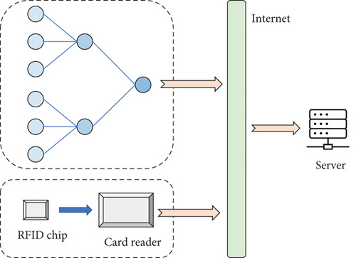
The rural tourism resource system consists of RFID system and multisensor system, which mainly realize the data collection function. The data required to be collected include tourists’ geographical location information, historical relics’ location information, as well as temperature, humidity, and wind data of key areas. Among them, the location information of tourists and cultural relics can be collected by RFID system. Temperature, humidity, and wind information can be collected through a multisensor system. The overall hardware composition is shown in Figure 2.
2.1. Multisensor System
Multisensor network is a network system consisting of multiple sensor nodes distributed in certain specific areas according to certain coverage requirements. By connecting various types of sensors, the system transmits and summarizes the specified data information in a distributed environment to a computer management terminal by means of signals in an accurate and real-time manner. Subsequently, the management terminal is used to control and manage the wireless sensor network and related facilities, thus completing the required application services. The system collects temperature, humidity, and wind speed data of visitors through sensing devices and uses ZigBee technology to form a wireless sensor network to transmit data information.
According to the technology specified by ZigBee is a short-range, low-power wireless communication technology, mainly applicable to the field of automatic control and remote control, which can be embedded in various devices. To be specific, ZigBee defines 3 basic topologies: star topology, cluster topology, and mesh topology. The ZigBee network topology is shown in Figure 3.
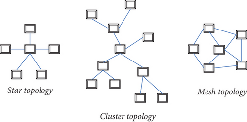
Star structure is less energy consuming and simple to deploy, but less ductile. The mesh structure is more reliable but consumes more energy. Cluster structure has the advantages of both low energy consumption and good scalability and repairability. At the same time, the number of nodes and communication range are limited due to the wide range of monitoring in the scenic area and need to be deployed in key areas and remote spots of the scenic area. Therefore, a cluster type structure is chosen for the node arrangement in the scenic area weather information monitoring system.
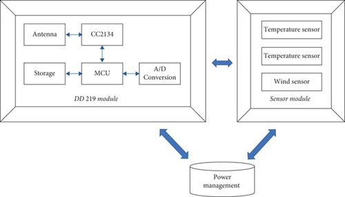
The sensor node model consists of a processor, a sensor, a ZigBee transceiver, and a power module. The processor is divided into two parts: microcontrol unit and memory. The microcontrol unit is responsible for processing the data collected by the sensors and managing the control information, and the memory is used to store the sensors and routing information. The ZigBee transceiver is used to transmit and receive data wirelessly. The actual sensor node used in the system is mainly composed of DD219 module, sensor module, and power supply device. The hardware configuration of ZigBee sensor node is shown in Figure 4.
2.2. RFID System
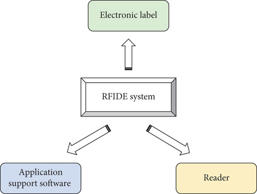
RFID system is usually composed of several parts, such as electronic tags, readers, and application support software (Figure 5). The electronic tag has a unique electronic code; the tag stores a certain format of electronic data, often as the identification information of the item to be identified. The reader and the electronic tag can carry out data transmission according to the agreed communication protocol. Usually in the contactless mode, the reader sends out the data collection command; the electronic label parses the command according to the communication protocol and then transmits the identification data in the memory back to the reader.
The main function of RFID tags is to store the coded information of the items to be identified. Unlike bar codes, which are read passively, RFID tags must automatically or, under the prompting of an external force, actively transmit the internal data information. They are usually low-power integrated circuits with magnetic field induction coils, antennas, storage media, and controllers. Due to differences in classification standards, tags have multiple categories.
Depending on the power supply method, electronic tags can be divided into active tags and passive tags. The active tag obtains electrical power through an internally embedded battery, so it has sufficient power and high circuit stability. Its main disadvantage is that the size of the tag is larger, the production cost is higher, and the service life is limited by the battery power. In addition, with the gradual consumption of electrical energy, the distance of signal transmission will become shorter and shorter, which eventually affects the normal operation of the RF system. Passive tags do not have internal batteries and require external energy to read properly. The more common energy-capable devices used in passive tags are coils and antennas. When the tag enters a specific working area, the antenna will receive electromagnetic waves, so the coil produces induction current, after the circuit integration to provide energy to the tag. Passive tags can be used for a long time or even permanently and are suitable for use in systems where chip information is frequently read and written. It has low production cost and long life and is lighter than active tags, also known as passive tags. The main disadvantage of passive tags is that the data reading distance is short, and the signal strength is limited by the size of the current, so a reader with high sensitivity is needed to achieve reliable reading.
As to the type of electronic chip used and the actual system function, there are significant differences in the design of the reader. The most basic function of the reader is to read the data from the electronic chip. In addition to this, the reader also requires signal state control, parity error checking, and other functions. The electronic chip contains not only the valid information to be transmitted but also specific additional data. The reader controls the reception and transmission of the data stream by means of the additional information it reads. From the technical realization aspect, the core of the RFID technology is the selection of the electronic tag, and the reader is designed according to the electronic tag. Although the reader in RFID system is much more expensive than the electronic tag, but in the actual application, the number of electronic tags is very large, and the number of readers used will be much less. The performance of the reader used in the rural tourism resource system is shown in Table 1.
| Parameter | Specification |
|---|---|
| Signal modulation method | GSHK |
| Frequency | 1.65 GHz |
| Communication distance | 10-20 m |
| Power | +12 V DC |
| Communication interface | JK234 |
| Operating temperature | -20~60 Celsius |
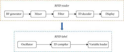
The reader mainly sends RF signals of specific frequency through the antenna. When the electronic chip enters the working area of the transmitting antenna, it generates an induction current. It is then activated by the electrical energy and sends the internal coded information through the chip’s built-in antenna. The system receives the carrier signal from the tag antenna and transmits it to the reader via the reader antenna, which demodulates and decodes the received signal and sends it to the server for corresponding processing. The principle of communication between the RFID reader and the electronic chip is shown in Figure 6.
In the rural tourism system, the main applications of RFID system are as follows. First, the scenic area is divided into small independent areas. In these small areas of some key location points, set RFID readers, and try to keep the role of these readers area does not interfere with each other, specifically, can use the reading method of timing polling and set the reader reading card cycle time. When a visitor carries an RFID electronic ticket through a specific area, RFID readers in that area read all the electronic ticket information within the sensing range. The collected data can then be sent to a data processing center for consolidation and analysis.
3. Geographic Information Big Data
Geographic information big data analysis is the technology required to realize online geographic information services on the Internet. The application of this technology has important practical significance in promoting the wide application of mapping results, promoting the common construction and sharing of geographic information resources, and transforming geographic information services. In addition, the big data technology of geographic information can promote geographic information to better serve the development of tourism resources. With the rapid development of tourism industry, the demand of tourists for tourism geographic information services is getting higher and higher. The application of big data analysis technology of geographic information can solve the bottleneck problem of tourism GIS and provide authoritative geographic information service for the establishment of rural tourism resource system.
3.1. Framework of Geographic Information Big Data
The tourism resource management system built based on the public service platform of geographic information adopts the technology of geographic information big data to realize the design of UI layer. Then, the UI layer is designed by calling the service interface abstracted by the platform to load the data provided by the platform, such as digital line map, orthophoto map, and tourism thematic data. The digital line drawing data is mainly based on the public map data, and various public information collected is overlaid, and the content is reduced and simplified to generate tile data. It should be noted that the compiled electronic map data and its tile data need to pass the audit of the administrative department of surveying and mapping at or above the provincial level and obtain the audit number before they can be run on the Internet as public data. The framework of geographic information big data can be seen in Figure 7.

3.2. Database Construction
The database construction of the geographic information public service platform is the basis for the platform to provide geographic information services, which is used to store a variety of spatial data, basic mapping cattle production data, and other kinds of thematic data. The database composition of the geographic information public service platform is shown in Figure 8.
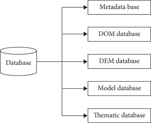
DEM and DOM data can be stored in the library, or the data can be stored in the form of files, and a file search directory can be established. DOM data are stored in two ways: in chunks and in whole chunks after fusion. Then, tiles are generated according to the rules, stored in file format, and indexed using multilevel subdirectories. The thematic database is mainly established for the geographic information data required by various thematic applications running on the geographic information public service platform. For example, the tourism-specific data applied in the tourism resource management system based on the public service platform of geographic information studied in the thesis. Specifically, the establishment of tourism thematic database is realized by collecting and organizing relevant business data and thematic application data after conducting a large amount of market research on tourist attractions and tourists, etc.
4. Conclusion
Geographic information data describe the patterns of natural events. Because of the large variety and volume of this data, it is of great importance to analyze and mine it. In this paper, we conduct a visualization study of the geographic information data in rural tourism resources in the context of digital earth and smart city advocated by the state. On this basis, this study designs and develops a tourism resource management system based on the public service platform of geographic information from the user requirements and the results of digital city construction. The system takes the public users as the target, closely combines the tourism thematic data with geospatial data, and realizes the map visualization of the traditional tourism resources with the map as the platform. Therefore, the system is able to provide different tourism services to the public users. In addition, the application of plug-in technology to the development of the tourism system provides the greatest convenience for updating, maintaining, and expanding the system later. It also provides a digital, professional, scientific, and networked management platform for managers to improve work efficiency and decision-making.
However, the system designed in this paper is only a visual presentation, and its analysis and early warning still need to rely on human judgment. The next step of research is how to automate the analysis and early warning based on existing data to provide real intelligent help for tourism resource development and rural disaster prevention.
Conflicts of Interest
The author declares that there are no conflicts of interest.
Acknowledgments
The study was supported by the “Young Backbone Teachers Support Program of Henan Polytechnic University, China (grant no. 2019XQG-13)”, by the Soft Science Project of Henan Province in 2019 (grant no. 192400410200), and by the Soft Science Project of Henan Province in 2022 (grant no. 222400410174).
Open Research
Data Availability
The labeled dataset used to support the findings of this study are available from the corresponding author upon request.


