[Retracted] Topological Sustainability of Crop Water Requirements and Irrigation Scheduling of Some Main Crops Based on the Penman-Monteith Method
Abstract
The following method was used to apply the topology of the current study of evapotranspiration ETo, net irrigation demand, irrigation schedules, and total effective rain fall of different crop models: using the Food and Agriculture Organization′s (FAO) CROPWAT 8.0 standard software and the CLIMWAT 2.0 tool and the FAO-56 Penman-Monteith approach to examine the variable topology of evapotranspiration ETo. Due to high temperatures in summer with an annual mean of 6.33 mm/day, the topological demonstration of reference evapotranspiration (ETo) increases from 2.84 mm/day in January to a maximum of 9.61 mm/day in July. Effective rainfall fluctuates from 0 mm to 53.4 mm. Total irrigation topological indices requirements were 308.3 mm/dec, 335.9 mm/dec, 343.6 mm/dec, 853 mm/dec, and 1479.6 mm/dec for barley, wheat, maize, rice, and citrus, respectively. The physical topological indices due to low demand in winter and high demand in summer, the total net irrigation, and gross irrigation for clay loamy soils for wheat (210.6 mm and 147.4 mm), barley (176.6 mm and 123.6 mm), citrus (204.5 mm and 143.2 mm), and maize (163.9 mm and 114.7 mm), but not for rice. This topology demonstrates that wheat has 4, barley has 4, citrus has 12, maize has 4, and rice crop has 12 irrigation schedules in a year.
1. Introduction
The topology of agricultural technology development for wheat, rice, maize, citrus, and barley in Saudi Arabia faces enormous challenges, which are average of arid areas described with water shortage, low precipitation, and above average evapotranspiration requirement. The greatest source of irrigation water is acquired from groundwater. The farming segment expended more than 85% of water ingesting, which achieved more than 23 billion m3 in 2012; see [1]. An efficient and precise assessment of CWR is necessary for preparing, constructing, operating, and controlling farm systems due to a rise in the demand of water with time. Precise assessment of CWR can assist to sustain cost-effective utilization of water reserves for irrigation. Evapotranspiration (ET) performs the most important part in topological sustainability of irrigation water [2].
Groundwater is an important source of freshwater of strategic importance for a country’s and its people’s long-term development. Management of water resources has become a hot topic in recent years, with the goal of ensuring sustained quality and availability while also meeting economic and social development objectives [3, 4].
Under conditions of limited water resources, the CROPWAT model can help improve useful suggestions for increasing yield production [5]. It enables the expansion of irrigation practice suggestions, the design of irrigation timetables under various water allocation requirements, and the estimation under rainfed or shortfall irrigation conditions. The approximate yield reduction is caused by water pressure and climate factors. According to the modeling results, the significant yield decline occurred in the embryonic stage in both rainfed and watered situations [6, 7].
CROPWAT and CLIMWAT softwares are used by many researchers for the estimation of CWR, and irrigation pattern and preparation. These tools were built by the “Food and Agriculture Organization” (FAO) for assisting researchers in water irrigation investigations and irrigation sustainability [7–11]. CLIMWAT is a climate data bank that works in conjunction with software application CROPWAT. CROPWAT uses meteorological data from over 5000 climate stations across the world to determine agricultural water requirements, irrigation source, and planning for a range of crops. Aimed at the stations in its database, CLIMWAT delivers lengthy-term monthly base values of the climatical limitations required for the Penman-Monteith method computation of evapotranspiration: mean relative humidity, mean high daily temperature, mean minimum daily temperature, mean sunshine hours, mean wind speed, and monthly total and effective rainfall [9, 12]. In the current analysis, the IWR and irrigation scheduling of rice, maize, citrus, barley, and wheat in Qassim region, Saudi Arabia, were investigated using the CLIMWAT and CROPWAT models.
2. Methodology and Materials
2.1. Working Area
Al-Qassim Province, as shown in Figure 1, is located at the heart of Saudi Arabia, geographically at the center of the Arabian Peninsula. The total population of this region is 1370727 and the total area of this region is 58046 km2. This region is an agricultural asset of Saudi Arabia. The total cultivated area is 453099 m2, the total harvest area is 427050.1 m2, and the total production is 236505 (ton) [13]. The average minimum and maximum temperatures are 16.5°C and 31.4°C in 2019. The average humidity, wind, and sunshine of this region are 30%, 238 km/day and 8.1 per hour, respectively. The latitude and longitude of Qassim are 26°30’N and 43°76’E with an altitude of 650 m. The average rainfall of Qassim is 183 mm [14–16].

2.2. Topology of FAO Penman-Monteith Method to Estimate Reference Evapotranspiration (ETo)
In Table 1 results in column 9 show that the ETo gradually increases from nearly 2.84 mm/day in January to the highest worth of approximately 9.61 mm/day in Jul. Then it again declines steadily to 2.97 mm/day in December as shown in Table 1 and Figure 1. The maximum ETo rises from 5.26 to 6.98 mm/day in April. The average yearly ETo was 6.33 mm/day in 2019.
| Month | Tmin °C | Tmax °C | Tmean °C | Humidity % | Wind km/day | Sun hours | Radiation MJ/m2/day | ETo mm/day | Rainfall (mm) | Effective rainfall (USDA S. C. method) (mm) |
|---|---|---|---|---|---|---|---|---|---|---|
| January | 6.5 | 18.4 | 12.45 | 52 | 216 | 6.8 | 13.4 | 2.84 | 18.0 | 17.5 |
| February | 8.2 | 21.6 | 14.9 | 43 | 216 | 7.9 | 16.7 | 3.77 | 10.0 | 9.8 |
| March | 12.3 | 26.4 | 19.35 | 36 | 259 | 6.7 | 17.5 | 5.26 | 59.0 | 53.4 |
| April | 16.9 | 30.9 | 23.9 | 31 | 302 | 7 | 19.6 | 6.98 | 37.0 | 34.8 |
| May | 22 | 36.9 | 29.45 | 24 | 302 | 8.3 | 22.4 | 8.79 | 4 | 4 |
| June | 23.7 | 40.5 | 32.1 | 16 | 259 | 10.3 | 25.5 | 9.47 | 0 | 0 |
| July | 24.5 | 41.4 | 32.95 | 16 | 259 | 10.2 | 25.2 | 9.61 | 0 | 0 |
| August | 24.4 | 41.1 | 32.75 | 13 | 216 | 10 | 24.2 | 8.6 | 0 | 0 |
| September | 22.4 | 39.4 | 30.9 | 17 | 173 | 8.5 | 20.6 | 6.96 | 0 | 0 |
| October | 17.2 | 33.9 | 25.55 | 23 | 216 | 8.2 | 17.8 | 6.31 | 4 | 4 |
| November | 12.4 | 25.8 | 19.1 | 38 | 216 | 8 | 15.2 | 4.37 | 20.0 | 19.4 |
| December | 7.8 | 20.1 | 13.95 | 51 | 216 | 5.4 | 11.3 | 2.97 | 31.0 | 29.5 |
| Total | 183 | 172.3 | ||||||||
| Average | 16.5 | 31.4 | 23.95 | 30 | 238 | 8.1 | 19.1 | 6.33 |
In Table 1, the maximum effective rainfall was 53.4 mm in November, 2019, although it was zero in June to September and between 4 mm and 37 mm in the other months of year 2019. The total twelve-month effective rainfall was expected to be 172.3 mm. There are various approaches to estimate the effective rainfall, e.g., fixed percentage 80%, dependable rain (FAO/AGLW method), empirical formula, and no rainfall. But, in this study, we use the US Agriculture Department of Soil Conservation Service (USAD S. C.) method which has developed a technique for determining effective rainfall using long-term meteorological and soil quality data. Perusing 50 years of rainfall information at 22 experimental stations representing various meteorological and soil conditions resulted in a complete analysis. Each day, the soil moisture balance was calculated by subtracting consumptive usage from the previous day’s balance and adding effective rainfall or irrigation. The soil input rate and rainfall intensities are not taken into account in this method to avoid a high level of complexity [2].
2.3. Crop Water Requirement (CWR) or Crop Evapotranspiration (ETc)
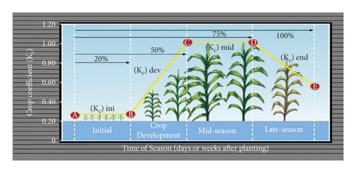
2.4. Topology of Net Irrigation Water Requirement (NIWR)
3. Discussion and Results
The region (Saudi Arabia), climatic location (Al-Qassim region), name of crop, sowing and harvesting period, and soil information were all included in the CROPWET and CLIMWAT package data (black clay soil). Once all data have been entered into the system, we calculate ETo using the Penman-Monteith method (equation (1)) and effective rainfall using the USDA S. C. method ((2a) and (2b)). The IWRs and effective rain of rice, wheat, citrus, maize (grain), and barley are shown in Tables 2–6. The CROPWAT program [9] was used to calculate all of the results. The crop’s scientific name, critical depletion, sowing and harvesting times, Kc value, rooting depth (m), yield response friction at various phases (beginning, growing, mid-season, and late-season), total number of days required for completion, and croup height (m) are shown in Tables 7–11.
| Year/Mon. | Decade | Stages | Kc | ETc mm/day | ETc mm/dec | Effective rainfall mm/dec | IWR mm/dec |
|---|---|---|---|---|---|---|---|
| Nov. | 2 | Nure | 1.20 | 0.52 | 3.1 | 6.7 | 0 |
| Nov. | 3 | Nurs/LPr | 1.12 | 2.68 | 26.8 | 7.8 | 110.1 |
| December | 1 | Nurs/LPr | 1.06 | 3.59 | 35.9 | 3.1 | 122.8 |
| December | 2 | Initial | 1.09 | 3.12 | 31.2 | 0.2 | 89.1 |
| December | 3 | Initial | 1.10 | 3.15 | 34.7 | 0.6 | 34 |
| January | 1 | Dev | 1.11 | 3.14 | 31.4 | 1 | 30.3 |
| January | 2 | Dev | 1.15 | 3.17 | 31.7 | 0.9 | 30.7 |
| January | 3 | Dev | 1.20 | 3.70 | 40.7 | 2.5 | 38.1 |
| February | 1 | Mid | 1.23 | 4.25 | 42.5 | 5.2 | 37.2 |
| February | 2 | Mid | 1.23 | 4.63 | 46.3 | 7.1 | 39.1 |
| February | 3 | Mid | 1.23 | 5.24 | 41.9 | 5 | 37 |
| March | 1 | Mid | 1.23 | 5.85 | 58.5 | 1 | 57.5 |
| March | 2 | Late | 1.22 | 6.42 | 64.2 | 0 | 64.2 |
| March | 3 | Late | 1.17 | 6.85 | 75.4 | 0.8 | 74.6 |
| April | 1 | Late | 1.13 | 7.22 | 72.2 | 4 | 68.2 |
| April | 2 | Late | 1.10 | 7.66 | 23 | 1.7 | 20.1 |
| Total | 659.3 | 47.9 | 853.0 |
| Year/Mon. | Decade | Stages | Kc | ETc mm/day | ETc mm/dec | Effective rainfall mm/dec | IWR mm/dec |
|---|---|---|---|---|---|---|---|
| December | 2 | Init | 0.3 | 0.86 | 5.2 | 6.5 | 0 |
| December | 3 | Init | 0.3 | 0.86 | 9.5 | 9.2 | 0.3 |
| January | 1 | Init | 0.3 | 0.85 | 8.5 | 7.1 | 1.4 |
| January | 2 | Dev | 0.38 | 1.05 | 10.5 | 5.7 | 4.8 |
| January | 3 | Dev | 0.68 | 2.1 | 23.2 | 4.9 | 18.3 |
| February | 1 | Dev | 0.99 | 3.43 | 34.3 | 2.5 | 31.8 |
| February | 2 | Mid | 1.18 | 4.44 | 44.4 | 0.9 | 43.6 |
| February | 3 | Mid | 1.18 | 5.04 | 40.4 | 6.5 | 33.8 |
| March | 1 | Mid | 1.18 | 5.63 | 56.3 | 14.9 | 41.4 |
| March | 2 | Mid | 1.18 | 6.22 | 62.2 | 20.7 | 41.5 |
| March | 3 | Late | 1.11 | 6.46 | 71.1 | 17.7 | 53.4 |
| April | 1 | Late | 0.81 | 5.22 | 52.2 | 14 | 38.2 |
| April | 2 | Late | 0.52 | 3.64 | 36.4 | 12.2 | 24.2 |
| April | 3 | Late | 0.33 | 2.5 | 7.5 | 2.6 | 3.2 |
| Total | 461.5 | 125.2 | 335.9 |
| Year/Mon. | Decade | Stages | Kc | ETc mm/day | ETc mm/dec | Effective rainfall mm/dec | IWR mm/dec |
|---|---|---|---|---|---|---|---|
| December | 2 | Init | 0.74 | 2.12 | 12.7 | 6.5 | 3.1 |
| December | 3 | Init | 0.7 | 2 | 22.1 | 9.2 | 12.9 |
| January | 1 | Init | 0.7 | 1.97 | 19.7 | 7.1 | 12.7 |
| January | 2 | Init | 0.7 | 1.92 | 19.2 | 5.7 | 13.5 |
| January | 3 | Init | 0.7 | 2.16 | 23.8 | 4.9 | 18.9 |
| February | 1 | Init | 0.7 | 2.42 | 24.2 | 2.5 | 21.7 |
| February | 2 | Dev | 0.7 | 2.64 | 26.4 | 0.9 | 25.5 |
| February | 3 | Dev | 0.7 | 2.99 | 24 | 6.5 | 17.4 |
| March | 1 | Dev | 0.7 | 3.35 | 33.5 | 14.9 | 18.6 |
| March | 2 | Dev | 0.7 | 3.71 | 37.1 | 20.7 | 16.4 |
| March | 3 | Dev | 0.71 | 4.12 | 45.3 | 17.7 | 27.6 |
| April | 1 | Dev | 0.71 | 4.53 | 45.3 | 14 | 31.3 |
| April | 2 | Dev | 0.71 | 4.95 | 49.5 | 12.2 | 37.3 |
| April | 3 | Dev | 0.71 | 5.39 | 53.9 | 8.5 | 45.3 |
| May | 1 | Dev | 0.71 | 5.87 | 58.7 | 3.9 | 54.8 |
| May | 2 | Mid | 0.71 | 6.33 | 63.3 | 0.1 | 63.3 |
| May | 3 | Mid | 0.71 | 6.47 | 71.2 | 0 | 71.1 |
| June | 1 | Mid | 0.71 | 6.59 | 65.9 | 0.1 | 65.7 |
| June | 2 | Mid | 0.71 | 6.75 | 67.5 | 0 | 67.5 |
| June | 3 | Mid | 0.71 | 6.78 | 67.8 | 0 | 67.8 |
| July | 1 | Mid | 0.71 | 6.86 | 68.6 | 0 | 68.6 |
| July | 2 | Mid | 0.71 | 6.91 | 69.1 | 0 | 69.1 |
| July | 3 | Mid | 0.71 | 6.65 | 73.2 | 0 | 73.2 |
| August | 1 | Mid | 0.71 | 6.37 | 63.7 | 0 | 63.7 |
| August | 2 | Mid | 0.71 | 6.13 | 61.3 | 0 | 61.3 |
| August | 3 | Mid | 0.71 | 5.74 | 63.2 | 0 | 63.2 |
| September | 1 | Mid | 0.71 | 5.3 | 53 | 0 | 53 |
| September | 2 | Late | 0.74 | 5.05 | 50.5 | 0 | 50.5 |
| September | 3 | Late | 0.74 | 4.92 | 49.2 | 0.1 | 49 |
| October | 1 | Late | 0.74 | 4.86 | 48.6 | 0.5 | 48 |
| October | 2 | Late | 0.74 | 4.72 | 47.2 | 0.8 | 46.4 |
| October | 3 | Late | 0.74 | 4.22 | 46.5 | 2.7 | 43.8 |
| November | 1 | Late | 0.74 | 3.7 | 37 | 4.9 | 32.1 |
| November | 2 | Late | 0.74 | 3.22 | 32.2 | 6.7 | 25.6 |
| November | 3 | Late | 0.74 | 2.88 | 28.8 | 7.7 | 21.1 |
| December | 1 | Late | 0.74 | 2.49 | 24.9 | 9.4 | 15.5 |
| December | 2 | Late | 0.74 | 2.12 | 8.5 | 4.3 | 3.1 |
| Total | 1656.4 | 172.5 | 1479.6 |
| Year/Mon. | Decade | Stages | Kc | ETc mm/day | ETc mm/dec | Effective rainfall mm/dec | IWR mm/dec |
|---|---|---|---|---|---|---|---|
| December | 2 | Init | 0.3 | 0.86 | 5.2 | 6.5 | 0 |
| December | 3 | Init | 0.3 | 0.86 | 9.5 | 9.2 | 0.3 |
| January | 1 | Dev | 0.37 | 1.06 | 10.6 | 7.1 | 3.5 |
| January | 2 | Dev | 0.63 | 1.74 | 17.4 | 5.7 | 11.7 |
| January | 3 | Dev | 0.92 | 2.83 | 31.1 | 4.9 | 26.2 |
| February | 1 | Mid | 1.18 | 4.09 | 40.9 | 2.5 | 38.3 |
| February | 2 | Mid | 1.24 | 4.66 | 46.6 | 0.9 | 45.7 |
| February | 3 | Mid | 1.24 | 5.28 | 42.2 | 6.5 | 35.7 |
| March | 1 | Mid | 1.24 | 5.89 | 58.9 | 14.9 | 44 |
| March | 2 | Late | 1.23 | 6.5 | 65 | 20.7 | 44.2 |
| March | 3 | Late | 1.03 | 6.01 | 66.1 | 17.7 | 48.5 |
| April | 1 | Late | 0.72 | 4.61 | 46.1 | 14 | 32.1 |
| April | 2 | Late | 0.45 | 3.17 | 25.3 | 9.7 | 13.2 |
| Total | 464.9 | 120.2 | 343.6 |
| Year/Mon. | Decade | Stages | Kc | ETc mm/day | ETc mm/dec | Effective rainfall mm/dec | IWR mm/dec |
|---|---|---|---|---|---|---|---|
| December | 2 | Init | 0.3 | 0.86 | 5.2 | 6.5 | 0 |
| December | 3 | Dev | 0.31 | 0.89 | 9.8 | 9.2 | 0.6 |
| January | 1 | Dev | 0.56 | 1.59 | 15.9 | 7.1 | 8.8 |
| January | 2 | Dev | 0.91 | 2.5 | 25 | 5.7 | 19.4 |
| January | 3 | Mid | 1.17 | 3.6 | 39.6 | 4.9 | 34.7 |
| February | 1 | Mid | 1.18 | 4.07 | 40.7 | 2.5 | 38.1 |
| February | 2 | Mid | 1.18 | 4.43 | 44.3 | 0.9 | 43.4 |
| February | 3 | Mid | 1.18 | 5.01 | 40.1 | 6.5 | 33.6 |
| March | 1 | Mid | 1.18 | 5.6 | 56 | 14.9 | 41.1 |
| March | 2 | Late | 1.11 | 5.85 | 58.5 | 20.7 | 37.8 |
| March | 3 | Late | 0.81 | 4.7 | 51.7 | 17.7 | 34 |
| April | 1 | Late | 0.48 | 3.08 | 30.8 | 14 | 16.8 |
| April | 2 | Late | 0.28 | 1.96 | 5.9 | 3.6 | 0 |
| Total | 423.4 | 114.2 | 308.3 |
| Crop Name | Rice | Scientific Name | Oryza sativa | |||||
|---|---|---|---|---|---|---|---|---|
| Planting date (KSA) | 15th December, 2020 | |||||||
| Harvest date | 13th April, 2021 | Growth stage | ||||||
| Stages | Nursery | Land prep | Initial | Develop | Mid | Late | Total | |
| Total | Puddling | |||||||
| Length (days) | 30 | 20 | 5 | 20 | 30 | 40 | 30 | 150 |
| Kc dry values | 0.70 | 0.30 | 0.50 | ⟶ | 1.05 | 0.70 | ||
| Kc wet value | 1.20 | 1.05 | 1.10 | ⟶ | 1.20 | 1.05 | ||
| Rooting depth (m) | 0.10 | ⟶ | 0.60 | 0.60 | ||||
| Puddling depth (m) | 0.40 | |||||||
| Nursery area (%) | 10 | |||||||
| Critical depletion | 0.20 | 0.20 | ⟶ | 0.20 | 0.20 | |||
| Yield response friction | 1 | 1.09 | 1.09 | 1.09 | 1.09 | |||
| Crop height (m) | 1 | |||||||
- Only for rice crop we added nursery and land preparation time and Kc wet value; results show that at nursery stage, the Kc dry values and Kc wet values are 0.70 and 1.20; at land preparation stage, the Kc dry values and Kc wet values are 0.30 and 1.05; at land preparation stage, the Kc dry values and Kc wet values are 0.30 and 1.05; at initial and developing stages, the Kc dry values and Kc wet values are 0.50 and 1.10; at mid-season stage, the Kc dry values and Kc wet values are 0.05 and 1.20; and at late season stage, the Kc dry values and Kc wet values are 0.70 and 1.05.
| Crop Name | Spring Wheat | Scientific Name | Triticum aestivum | ||
|---|---|---|---|---|---|
| Planting date (KSA) | 15th December 2020 | ||||
| Harvest date | 23rd April 2021 | ||||
| Stages | Initial | Develop | Mid | Late | Total |
| Length (days) | 30 | 30 | 40 | 30 | 130 |
| Kc values | 0.30 | ⟶ | 1.15 | 0.30 | |
| Rooting depth (m) | 0.30 | ⟶ | 1.20 | 1.20 | |
| Critical depletion | 0.55 | ⟶ | 0.55 | 0.80 | |
| Yield response friction | 0.40 | 0.60 | 0.80 | 0.40 | |
| Crop height (m) | 1 | ||||
- The Kc value at the initial and developing stage is 0.30; at mid-season stage, the Kc is 1.15, and at late season stage, the Kc value is 0.30.
| Crop Name | Citrus ca bars | Scientific Name | Rutaceae | ||
|---|---|---|---|---|---|
| Planting date (KSA) | 15/12/2020 | ||||
| Harvest date | 14/12/2021 | ||||
| Stages | Initial | Develop | Mid | Late | Total |
| Length (days) | 60 | 90 | 120 | 95 | 365 |
| Kc values | 0.70 | ⟶ | .65 | 0.70 | |
| Rooting depth (m) | 1.40 | ⟶ | 1.40 | 1.40 | |
| Critical depletion | 0.50 | ⟶ | 0.50 | 0.50 | |
| Yield response friction | 1 | 1 | 1 | 1 | 1 |
| Crop height (m) | 4 | ||||
- The Kc value at the initial and developing stage is 0.70; at mid-season stage, the Kc is 0.65; and at the late season stage, the Kc value is 0.70.
| Crop Name | Maize Grain | Scientific Name | Zea mays | ||
|---|---|---|---|---|---|
| Planting date (KSA) | 15/03/2020 | ||||
| Harvest date | 17/07/2020 | ||||
| Stages | Initial | Develop | Mid | Late | Total |
| Length (days) | 20 | 35 | 40 | 30 | 125 |
| Kc values | 0.30 | ⟶ | 1.20 | 0.35 | |
| Rooting depth (m) | 0.30 | ⟶ | 1.00 | 1.00 | |
| Critical depletion | 0.55 | ⟶ | 0.55 | 0.80 | |
| Yield response friction | 0.40 | 0.40 | 0.30 | 0.50 | 1.25 |
| Crop height (m) | 2 | ||||
- The Kc value at initial and developing stage is 0.30; at mid-season stage, the Kc is 1.20; and at late season stage, the Kc value is 0.35.
| Crop Name | Barley | Scientific Name | Hordeum vulgare | ||
|---|---|---|---|---|---|
| Planting date (KSA) | 15/10/2020 | ||||
| Harvest date | 11/02/2021 | ||||
| Stages | Initial | Develop | Mid | Late | Total |
| Length (days) | 15 | 25 | 50 | 30 | 120 |
| Kc values | 0.30 | ⟶ | 1.15 | 0.25 | |
| Rooting depth (m) | 0.30 | ⟶ | 1.10 | 1.10 | |
| Critical depletion | 0.55 | ⟶ | 0.55 | 0.90 | |
| Yield response friction | 0.20 | 0.60 | 0.50 | 0.40 | 1.00 |
| Crop height (m) | 1 | ||||
- The Kc value at initial and developing stage is 0.30; at mid-season stage, the Kc is 1.15; and at late season stage, the Kc value is 0.25.
Tables 2–6 reveals the results of total irrigative water requirements (IWRs), total effective rainfall and crop evapotranspiration (ETc) of five crops (rice, wheat, citrus, maize, and barley) in Qassim region; KSA are according to this order respectively:
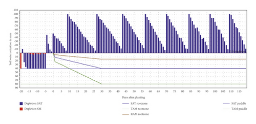
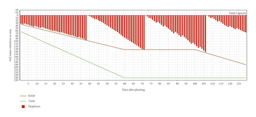
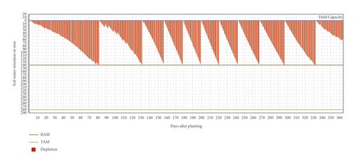
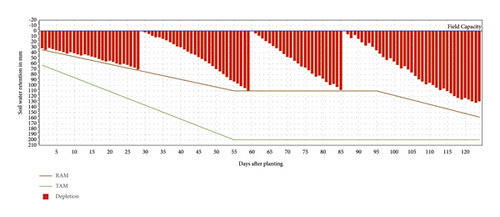
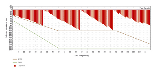
In Tables 2–6 results reveal that 172.5% of effective rainfall has been recorded by citrus, 152.2% has been recorded by wheat, 120.2%, 114.2%, and 47.9% have been recorded by maize, barley, and rice, respectively, and Tables 12–16 shows the net irrigation mean and gross irrigation mean for clay loamy soils for wheat (210.6 mm and 147.4 mm), barley (176.6 mm and 123.6 mm), citrus (204.5 mm and 143.2 mm), and maize (163.9 mm and 114.7 mm), but not for rice crop. This analysis demonstrates that wheat has 4, barley has 4, citrus has 12, maize has 4, and rice crop has 12 irrigation schedules in a year. Figures 3–7 demonstrate the irrigation schedules of rice, wheat, citrus, maize, and barley, respectively [21].
| Date | Day | Stage | Eta (%) | Puddl. | Rain (mm) | Ks (fract.) | Percol. | Depl. SM (mm) | Net Gift (mm) | Loss (mm) | Depl. (mm) |
|---|---|---|---|---|---|---|---|---|---|---|---|
| 25-Nov | −19 | PrePu | 90 | Prep | 0 | 0.9 | 0 | 41 | 91.3 | 0 | 40 |
| 10-Dec | −4 | Puddl | 100 | Prep | 0 | 1 | 0 | 4 | 90 | 0 | 40 |
| 14-Dec | 0 | Puddl | 100 | OK | 0 | 1 | 4.9 | 0 | 54.3 | 0 | 4.3 |
| 23-Dec | 9 | Init | 100 | OK | 4.8 | 1 | 3.1 | 0 | 95.5 | 0 | -4.5 |
| 10-Jan | 27 | Dev | 100 | OK | 0 | 1 | 3.1 | 0 | 100.4 | 0 | 0.4 |
| 26-Jan | 43 | Dev | 100 | OK | 0 | 1 | 3.1 | 0 | 95.3 | 0 | -4.7 |
| 9-Feb | 57 | Mid | 100 | OK | 0 | 1 | 3.1 | 0 | 95.3 | 0 | -4.7 |
| 22-Feb | 70 | Mid | 100 | OK | 0 | 1 | 3.1 | 0 | 100.8 | 0 | 0.8 |
| 8-Mar | 84 | Mid | 100 | OK | 0 | 1 | 3.1 | 0 | 98.3 | 0 | -1.7 |
| 21-Mar | 97 | End | 100 | OK | 0 | 1 | 3.1 | 0 | 100.1 | 0 | 0.1 |
| 2-Apr | 109 | End | 0 | 1 | 3.1 | 0 | 100.8 | 0 | 0.8 | ||
| 13-Apr | End | End | 2 | 1 | 38 | 0 |
- Depl. = Depletion (mm); Percol. = percolation; Ks is the adjustment coefficient for water stress.
| Date | Day | Stage | Rain (mm) | Ks (fract.) | Eta (%) | Depl. (%) | Net Irr. (mm) | Deficit (mm) | Loss (mm) | Gr. Irr. (mm) | Flow (L/s/ha) |
|---|---|---|---|---|---|---|---|---|---|---|---|
| 22-Jan | 8-Feb | Dev | 0 | 1 | 100 | 56 | 98.8 | 0 | 0 | 141.2 | 0.42 |
| 24-Feb | 12-Mar | Mid | 0 | 1 | 100 | 57 | 136.8 | 0 | 0 | 195.5 | 0.69 |
| 31-Mar | 16-Apr | End | 0 | 1 | 100 | 61 | 147.4 | 0 | 0 | 210.6 | 0.7 |
| 23-Apr | End | End | 2 | 1 | 100 | 25 |
| Date | Day | Stage | Rain (mm) | Ks (fract.) | Eta (%) | Depl. (%) | Net Irr. (mm) | Deficit (mm) | Loss (mm) | Gr. Irr. (mm) | Flow (L/s/ha) |
|---|---|---|---|---|---|---|---|---|---|---|---|
| 15-Dec | 1 | Init | 0 | 1 | 100 | 51 | 142.1 | 0 | 0 | 203 | 23.5 |
| 6-Mar | 82 | Dev | 0 | 1 | 100 | 51 | 141.9 | 0 | 0 | 202.7 | 0.29 |
| 25-Apr | 132 | Dev | 0 | 1 | 100 | 51 | 142.6 | 0 | 0 | 203.8 | 0.47 |
| 20-May | 157 | Mid | 0 | 1 | 100 | 50 | 140.4 | 0 | 0 | 200.6 | 0.93 |
| 11-Jun | 179 | Mid | 0 | 1 | 100 | 51 | 143.6 | 0 | 0 | 205.2 | 1.08 |
| 2-Jul | 200 | Mid | 0 | 1 | 100 | 51 | 142.2 | 0 | 0 | 203.2 | 1.12 |
| 23-Jul | 221 | Mid | 0 | 1 | 100 | 51 | 144 | 0 | 0 | 205.6 | 1.13 |
| 14-Aug | 243 | Mid | 0 | 1 | 100 | 51 | 141.5 | 0 | 0 | 202.1 | 1.06 |
| 8-Sep | 268 | Mid | 0 | 1 | 100 | 51 | 142.4 | 0 | 0 | 203.4 | 0.94 |
| 7-Oct | 297 | End | 0.3 | 1 | 100 | 51 | 143.7 | 0 | 0 | 205.2 | 0.82 |
| 12-Nov | 333 | End | 0 | 1 | 100 | 51 | 143.2 | 0 | 0 | 204.5 | 0.66 |
| 14-Dec | End | End | 0 | 1 | 0 | 21 |
| Date | Stage | Day | Rain (mm) | Ks (fract.) | Depl. (%) | Eta (%) | Net Irr. (mm) | Deficit (mm) | Loss (mm) | Gr. Irr. (mm) | Flow (L/s/ha) |
|---|---|---|---|---|---|---|---|---|---|---|---|
| 12-Jan | Dev | 29-Jan | 0 | 1 | 55 | 100 | 73.6 | 0 | 0 | 105.2 | 0.42 |
| 12-Feb | Mid | 29-Feb | 0 | 1 | 57 | 100 | 114.4 | 0 | 0 | 163.4 | 0.61 |
| 10-Mar | Mid | 26-Mar | 0 | 1 | 57 | 100 | 114.7 | 0 | 0 | 163.9 | 0.73 |
| 18-Apr | End | End | 0 | 1 | 64 | 100 |
| Date | Day | Stage | Rain (mm) | Ks (fract.) | Eta (%) | Depl. (%) | Net Irr. (mm) | Deficit (mm) | Loss (mm) | Gr. Irr. (mm) | Flow (L/s/ha) |
|---|---|---|---|---|---|---|---|---|---|---|---|
| 10-Jan | 27 | Dev | 0 | 1 | 100 | 56 | 93.5 | 0 | 0 | 133.6 | 0.57 |
| 11-Feb | 59 | Mid | 0 | 1 | 100 | 55 | 121.1 | 0 | 0 | 173 | 0.63 |
| 12-Mar | 88 | Mid | 0 | 1 | 100 | 56 | 123.6 | 0 | 0 | 176.6 | 0.7 |
| 13-Apr | End | End | 6.4 | 1 | 100 | 37 |
4. Conclusion
In these results, “ETo has increased from 2.84 mm/day to 9.61 mm/day, while effective rainfall has increased from 0 mm to 53.4 mm. For barley, wheat, maize, rice, and citrus, the overall IWRs were 308.3 mm/dec, 335.9 mm/dec, 343.6 mm/dec, 853 mm/dec, and 1479.6 mm/dec, respectively. Except for rice, total net irrigation and total gross irrigation for clay loamy soils are 210.6 mm and 147.4 mm, 176.6 mm and 123.6 mm, 204.5 mm and 143.2 mm, and163.9 mm and 114.7 mm, respectively, due to low demand in winter and high demand in summer. Wheat, barley, citrus, maize, and rice have irrigation schedules of 4, 4, 12, 4, and 12, respectively”, according to the data. Tables 2–6 show the novelty of this work.
Abbreviations
-
- IWR:
-
- Irrigation water requirements
-
- Dev.:
-
- Development
-
- Init.:
-
- Initial
-
- Irr. Req.:
-
- Irrigation requirement
-
- Gr. Irr.:
-
- Gross irrigation
-
- Net Irr.:
-
- Net irrigation
-
- ETc:
-
- Crop evapotranspiration
-
- ETo:
-
- Reference evapotranspiration
-
- NIR:
-
- Net irrigation requirement
-
- Depl.:
-
- Depletion
-
- Percol.:
-
- Percolation
-
- ITS:
-
- Irrigation time schedules
-
- IM:
-
- Irrigation management
-
- (USDA) S. C.:
-
- United States Department of Agriculture Soil Conservation
-
- P. M.:
-
- Penman-Monteith
-
- TAM:
-
- Total available moisture or the total amount of water available
-
- RAM:
-
- Readily available water or the quantity of TAM that the crop can pick up from the source not including water stress.
Conflicts of Interest
The authors declare that they have no conflicts of interest to report regarding the present study.
Authors’ Contributions
Methodology was developed by W. A.; investigation was carried out by W. A.; formal analysis was performed by M. K.; resources were provided by W. A. and J. R.; data collection was done by Z. A.; reviewing and editing were done by W. A. and M. A.; conceptualization was done by M. A.; software was provided by W. A. and J. R.; original draft was written by W. A. and M. K.
Acknowledgments
The authors extend their appreciation to the deputyship for Research & Innovation, Ministry of Education in Saudi Arabia for funding this research work through the project number IFP-2020-20.
Open Research
Data Availability
The data that support the findings of this study are available from the corresponding author upon reasonable request.


