Hydroid assemblages across the Atlantic–Mediterranean boundary: is the Strait of Gibraltar a marine ecotone?
Abstract
Strong gradients in physico-chemical properties between abutting water masses create prominent transition zones in the marine environment. The Strait of Gibraltar forms the well defined boundary between the Mediterranean and Atlantic, and this paper examines spatial variation of hydroid assemblages in this transition zone. Although several studies highlighted the transitional character of the Strait and defined it as an ecotone, the benthic hydroid assemblages did not show differences between the Gulf of Cádiz and the Alboran Sea. However, there is an asymmetrical influence of the Atlantic waters on the coastal benthic ecosystems of the Alboran Sea, which maintains a more Mediterranean character in the hydroid assemblages of the northern coast, whereas a more Atlantic character was found in the rest of the studied sites. The transition zone between Atlantic and Mediterranean benthic communities could be associated with an Atlantic Influence Zone rather than with the Strait of Gibraltar itself.
Introduction
The Strait of Gibraltar forms the boundary of three zoogeographical regions: Mauritanian, Mediterranean and Lusitanian (Carballo et al. 1997; Medel & López-González 1998). The Strait is the only natural communication between two different water masses (Candela 1991): the Mediterranean Sea, an almost isolated oceanic system, and a large ocean basin, the North Atlantic.
The Strait presents complex oceanographic processes and morphometry (García Lafuente et al. 2002; Jackson 2004). In general, the more saline and denser Mediterranean waters flow at depth westward through the Strait into the Atlantic and Atlantic waters flow above in an eastward direction, into the Mediterranean Sea (Bormans et al. 1986). The Gulf of Cádiz (including the Strait of Gibraltar) is characterized by tidal ranges exceeding 2 m (Candela 1991), whereas in the Alboran Sea the tidal range rarely reaches 15 cm (Larnicol et al. 2002). Moreover, in the Mediterranean, surface temperatures range between 11–13 °C in winter and 25–30 °C in summer (Bouillon et al. 2004). In the Gulf of Cádiz, surface temperature varies between 16.5 and 22.5 °C (Vargas et al. 2003). The seasonal pattern of benthic suspension feeders in the Mediterranean Sea differs from that in cold temperate seas, and a summer dormancy appears to be the predominant feature in their seasonal dynamic (Coma et al. 2000).
With regard to the biological properties of the Strait, studies on benthic organisms have highlighted its transitional character (Medel & Vervoort 1995; Carballo et al. 1997; Medel et al. 1998; Naranjo et al. 1998). These studies focused mainly on the European side of the Strait and their approach was to produce an extensive faunistic list on a local scale and compare it with similar lists from different localities on a presence–absence basis. Guerra-García et al. (2009) used a different approach, carrying out a community study and providing quantitative data on the peracarid fauna from the Strait of Gibraltar. They used a local scale (10s of kilometers around the Strait) and they did not find any clear change along the Mediterranean-Atlantic axis, concluding that this is a homogeneous area.
Although the transition between two different communities is generally designated as an ecotone (for instance Longhurst 2007), this name is often used for rapid transitions, usually associated with abrupt changes in the physical environment or in the external stress situation owing to human activities (Odum 1971). In the marine environment, ecotones are typically present in the shore, separating marine and terrestrial habitats, or within an estuary, separating the freshwater and seawater habitats (Attrill & Rundle 2002; Schlacher et al. 2008). But not all transitions between different communities exhibit these properties and different kinds of transition exist. For example, an ecocline is a more gradual transition usually associated to a gradual transformation of at least one major environmental factor (Whittaker 1970; Attrill & Rundle 2002).
This study examines spatial variation in hard bottom assemblages of hydroids on a regional scale (100s of kilometers), across the Atlantic–Mediterranean and the African–European axes. The fraction of hard bottoms contains a concentration of an important part of the biodiversity of the aquatic environments (Bianchi et al. 2004) and hydroids are among the most abundant and characteristic sessile animals of marine hard-bottom communities (Boero & Fresi 1986). The benthic hydroids have emerged as good bioindicators of environmental conditions (Boero 1984; Mergner 1997; Jones 2002). Finally, we explored the variation in the number of hydroid species across these two axes.
Material and Methods
Sampling and sorting
The study was conducted between August and September 2007. To explore the differences between the Atlantic and the Mediterranean hydroid assemblages we collected samples in seven sites (10s to 100s of kilometres apart), covering the Gulf of Cádiz (Eastern Atlantic Ocean) and the Alboran Sea (Western Mediterranean) (Fig. 1). Two stations (some 100s of meters to a few kilometres apart) were randomly selected in each site, with two transects in each station (some meters or 10s of meters apart). Every transect was subdivided into four depth bands (0/−5m, −5/−10m, −10/−15m and −15/−20 m), following the methodology of Boero & Fresi (1986). All localities were steep rocky cliffs with low levels of human use.
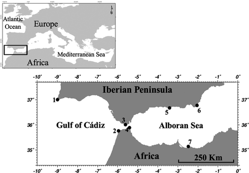
Field collections were made by SCUBA diving using visual collection techniques (Boero & Fresi 1986; Di Camillo et al. 2008; Puce et al. 2009). To homogenise the sampling effort, all samples were collected by the same, previously trained operators. The operator moved at a constant speed along each transect collecting samples of all substrates (and potential substrates) and colonies detected, in a band of 1 m wide. This methodology possibly has a lower quantitative precision than scratching off the complete surface of the sampling unit like quadrats, but it allows using a large sampling unit which more efficiently represents the hydroid diversity and microhabitat diversity in shallow coastal benthic habitats (Boero & Fresi 1986; Di Camillo et al. 2008; Puce et al. 2009). Specimens were sorted and identified to the maximum level of taxonomic resolution possible, in most cases to species level. Samples were preserved in either 90% ethanol or 4% formalin. Abundance estimates were made by counting the number of hydrocauli with polyps in the sample.
Spatial design and data analysis
Our design included five factors: (i) ‘Sea’ (fixed, two levels, Atlantic, the samples in the Gulf of Cádiz; and Mediterranean, the samples in the Alboran Sea samples); (ii) ‘Latitude’ (fixed, two levels, North, the samples located in the Iberian Coast; and South, the samples in the African Coast); (iii) ‘Depth’ (fixed, four levels: 0–5 m, 5–10 m, 10–15 m and 15–20 m); (iv) ‘Site’ (random, nested in Sea); (v) ‘Station’ (random, nested in Site). There were two replicates for every combination of depth × station.
We used a distance-based permutational multivariate analysis of variance (PERMANOVA; Anderson 2001; McArdle & Anderson 2001) to partition variance in assemblages composition according to the above design. The analysis was based on a Bray–Curtis similarities matrix on square root-transformed data as a distance measure among samples (Bray & Curtis 1957). The homogeneity of multivariate dispersion among the groups of each factor of interest was tested by PERMDISP (Anderson 2006).
Given that the previous analysis did not show significant differences in the factors ‘Sea’ and ‘Latitude’, we performed an exploratory analysis to look for significant evidence (P < 0.05) of genuine clusters in the assemblages data. We used a combination of CLUSTER analysis (on Bray–Curtis similarities matrix and group average algorithm) and ‘Similarity profile’ (SIMPROF) tests (Clarke & Gorley 2006). A SIMPROF test was performed at each significant node of the dendogram to ascertain whether the particular group of samples being subdivided contained significant internal differences.
Additionally, the possible changes in the number of species between Atlantic–Mediterranean and African–European assemblages were explored by means of a general linear model (GLM). We used the same experimental design as described for the multivariate analysis but using the complete transects as sampling units, without distinguishing depth bands. Data were rank-transformed (RT-1) (Conover & Iman 1981) to meet the assumptions of the analysis and the Newman–Keuls test (Underwood 1997) was used for a posteriori comparison of the means.
The total number of species per site was graphically explored with individual-based rarefaction curves (Gotelli & Colwell 2001).
SIMPROF-CLUSTER analysis, as well as the GLM, showed an area of Atlantic influence that included sites in the Atlantic and South Alboran Sea. In this area of Atlantic influence, we explored the relationship between the total number of species per site and the distance to the Strait, using a regression analysis. As a predictor variable we used the shortest distance through the sea between a given site and the central point of the Strait of Gibraltar.
Results
Spatial variability in assemblages composition
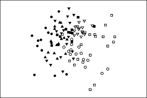
The nMDS plots in Fig. 2 shows the distribution of the samples from the two seas based on biological assemblages; it suggests that Atlantic and Mediterranean as well as north and south assemblages were not distinct. Results of the multivariate analyses using PERMANOVA are reported in Table 1, and revealed significant differences in the structure of the hydroid assemblages among depths but not between Atlantic and Mediterranean or with latitude. In addition, assemblages differed significantly among sites and stations within sites. The multivariate dispersion did not show significant differences within the four levels of the factor ‘Depth’ (PERMDISP F = 32.642, df1 = 3, df2 = 102, P(perm) = 0.089). Although the differences with depth gradient were significant, there was not a consistent pattern (see significant interactions in Table 1). Given their random nature, the differences in random factors and their interactions were not explored further.
| Source | df | SS | MS | Pseudo-F | P(perm) |
|---|---|---|---|---|---|
| Sea | 1 | 19,394 | 19,394 | 1.785 | 0.199 |
| Latitude | 1 | 13,083 | 13,083 | 1.205 | 0.332 |
| Depth | 3 | 14,410 | 4803.4 | 1.801 | 0.041a |
| Sea × Latitude | 1 | 13,042 | 13042 | 1.201 | 0.409 |
| Sea × Depth | 3 | 8707.9 | 2902.6 | 1.093 | 0.368 |
| Latitude × Depth | 3 | 5347.7 | 1782.6 | 0.675 | 0.889 |
| Sea × Depth × Latitude | 3 | 6973.3 | 2324.4 | 0.877 | 0.641 |
| Site (Sea × Latitude) | 3 | 31,898 | 10,633 | 3.130 | 0.001a |
| Station [Site (Sea × Latitude)] | 7 | 24,024 | 3432 | 2.793 | 0.001a |
| Depth × Site (Sea × Latitude) | 9 | 23,612 | 2623.6 | 1.496 | 0.003a |
| Depth × Station [Sea (Sea × Latitude)] | 21 | 37,036 | 1763.6 | 1.435 | 0.001a |
| Residual | 50 | 61,440 | |||
| Total | 105 | 264,810 |
- a Significant terms.
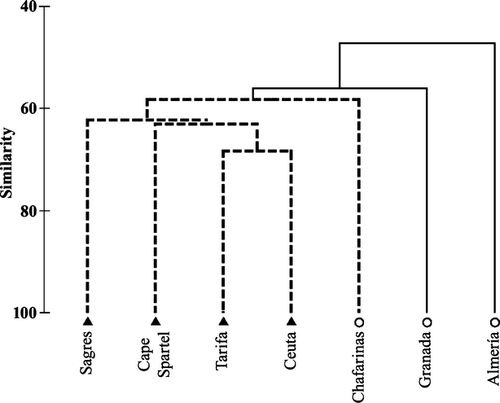
The SIMPROF (Fig. 3), detected a genuine cluster formed by Atlantic sites plus Chafarinas (Southern Alboran Sea). The analysis performed at this node confirmed that this group did not contain significant internal differences (π = 1.01; P = 0.267). The differences between this cluster and Granada (π = 1.37; P = 0.047) and between them and Almería (π = 2.97; P = 0.01) were significant.
Species richness
The total number of hydrocauli collected was 132, 138. The total number of hydroid taxa recorded was 105, comprising 20.5% of all Anthothecata and 51.6% of all Leptothecata described for the Mediterranean fauna (Bouillon et al. 2004).
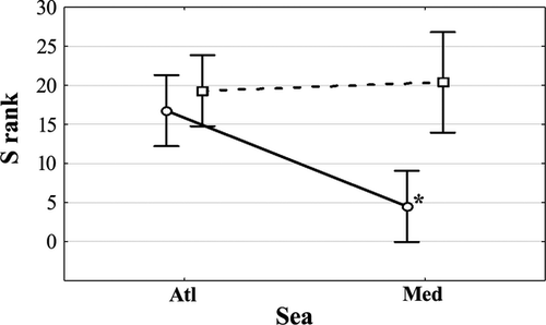
The univariate analysis of the number of species per transect showed significant interactions between ‘Sea’ and ‘Latitude’ (Table 2), indicating that the differences in ‘Latitude’ were not homogeneous across levels of the factor ‘Sea’. The analysis of the interaction by an a posteriori Newman–Keuls test confirmed as significant the lower number of species in the North Mediterranean with respect to the rest of the sites that could not be statistically distinguished. Given the significant interactions, the two levels of the factor ‘Latitude’ are represented separately in Fig. 4, showing the Newman–Keuls results. Tarifa (in the North) and Ceuta (in the South) showed the maximum average number of species per transect; Granada and Almería sites (in the North Mediterranean) showed the lowest average number of species (Fig. 4).
| SS | DF | F | P | |
|---|---|---|---|---|
| Sea | 256.562 | 1 | 9.7699 | 0.052 |
| Latitude | 484.777 | 1 | 18.4604 | 0.023a |
| Sea × Latitude | 283.556 | 1 | 10.7979 | 0.046a |
| Site (Sea × Latitude) | 78.781 | 3 | 2.4633 | 0.147 |
| Station [Site (Sea × Latitude)] | 74.625 | 7 | 0.2963 | 0.944 |
| Error | 503.750 | 14 |
- a Significant terms.
In agreement with the previous analysis, the rarefaction curves (Fig. 5) showed that Almería (46) and Granada (39) had the lowest total number of species per site and Tarifa (69) and Ceuta (68) the highest, with Cape Spartel (66), Chafarinas (62) and Sagres (59) in an intermediate position.
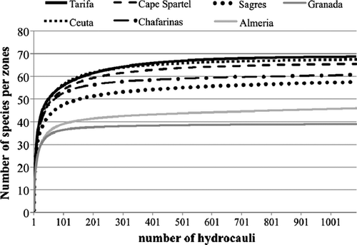
On the other hand, regression analysis revealed a clear negative correlation between the total number of species per site and the distance to the Strait of Gibraltar (r2 = 93.99%; P = 0.006). Tarifa and Ceuta presented the highest number of species, with these values decreasing as the distance to the Strait increased.
Discussion
The Atlantic Ocean and Mediterranean Sea have distinct hydrological and environmental conditions (Candela 1991). However, our results show that the multivariate structure of the coastal hydroid assemblages cannot be neatly distinguished between the two basins in the nearby coasts to the Strait of Gibraltar. The PERMANOVA analysis did not show significant differences in benthic hydroid assemblages on rocky shores.
The northern sites of the Alboran Sea showed a significantly lower number of species per transect. When exploring the Iberian Coast and the Moroccan Coast separately (Fig. 4), an abrupt transition between the Atlantic and Mediterranean in the north became apparent. At the southern coast, on the other hand, there is no evident change in the number of species between these two basins.
The Alboran Sea is strongly influenced by the inflowing Atlantic waters (Candela 1991), Indeed, the Alboran Sea is considered a ‘key point’ for new entries of Atlantic hydrozoan species into the Mediterranean (Ramil & Vervoort 1992; Medel & Vervoort 1995; Medel et al. 1998; Boero et al. 2003). This inflow creates an asymmetric circulation through the Strait and through the Alboran Sea (Echevarría et al. 2002; Skliris & Beckers 2009). The Atlantic water passes eastward along the northern part of the Alboran Sea (the Atlantic Jet) and forms two anticyclonic gyres (Western Alboran Gyre and Eastern Alboran Gyre), which reach the African Coast (La Violette & Lacombe 1988; Millot 1992; Vargas-Yáñez et al. 2002). The northern coast of the Alboran Sea, in contrast, is influenced by Mediterranean waters (Northern Current), coming from the Catalan Sea, and flowing down the Spanish Mediterranean Coast towards the Strait of Gibraltar (Bouzinac et al. 2003). Although this water mass loses its influence close to the Strait (Sarhan et al. 2000), it is likely to impart a typical Mediterranean character to the northern coast.
A summer impoverishment is a typical seasonal pattern in the Mediterranean coastal ecosystems, mainly for suspension feeders (Coma et al. 2000; Coma & Ribes 2003). Under these conditions, many hydrozoans disappear, leaving only dormant basal stolons (Boero & Fresi 1986; Bavestrello et al. 2006). However, this summer dormancy was not found in the southern site of the Alboran Sea (Chafarinas). Due to administrative and technical problems, we could not sample an additional site in the Southern Mediterranean area and the lack of replication within this area does not allow us to unequivocally distinguish whether this is a local phenomenon or whether it represents the typical situation at the southern coast of the Alboran Sea.
However, the most robust multivariate analysis (SIMPROF) showed that Chafarinas formed a cluster with the Atlantic sites, which supports the idea that this is a general phenomenon instead of a local exception. This cluster would constitute an area of Atlantic influence which would include the southern coast of the Alboran Sea, but the northern coast of this sea would be excluded. In the middle between these two coasts, in the Alboran Island (Maldonado & Uriz 1995) the presence of two different sponge assemblages was documented, one with a Mediterranean affinity and one with an Atlantic affinity, separated by an ecotone. The circulation of water masses in the Alboran Sea and their asymmetric influence on the pelagic environment is well known (for instance García Lafuente et al. 1998; Vargas-Yáñez et al. 2002; Bouzinac et al. 2003); our data provide the first indication that this may extend to benthic communities.
The Strait of Gibraltar is a very important biogeographical area and several studies have highlighted its transitional character (Medel & Vervoort 1995; Carballo et al. 1997; Medel et al. 1998; Naranjo et al. 1998). Some of researchers defined it as an ecotone (Naranjo et al. 1998). Ecotones can contain an increased number of species, incorporating faunal elements from both abutting systems (Attrill & Rundle 2002; Whitfield et al. 2012). Hydrozoan and sponge faunas in the Strait of Gibraltar have greater affinity with the Mauritanian region (Carballo et al. 1997; Medel & López-González 1998), but ascidians, anthozoans and opisthobranchs have a higher biogeographical affinity with the Mediterranean region (López-González 1993; Naranjo 1995; Naranjo et al. 1998; Cervera et al. 2004), whereas cheilostomate bryozoan fauna is more similar to the Boreal Province (López de la Cuadra & García-Gómez 1994). Furthermore, several studies have recorded a higher number of species in the Strait than in nearby areas (Carballo et al. 1997; Guerra-García & Izquierdo 2010; Izquierdo & Guerra-García 2011). And indeed, the Strait of Gibraltar (including European and African coasts) is considered a ‘hot spot’ for marine biodiversity (Templado 2011). Using a regional scale, we also recorded the highest number of species in the two sites in the Strait of Gibraltar (Tarifa and Ceuta, Fig. 5). The regression analysis also showed that the total number of species changes linearly with the distance to the Strait when we analysed the area of Atlantic influence. This supports the idea of its role as a regional ‘hot spot’ for biodiversity.
The term ecotone has been defined as a narrow transition zone of relatively rapid change between two different and relatively homogeneous community types (Odum 1971; Attrill & Rundle 2002). However, although several environmental variables change abruptly in the Strait of Gibraltar, such as tidal amplitude (Candela 1991), our results do not support the existence of two distinguishable hydroid assemblages in one side or the other of the Strait of Gibraltar. A more significant change in benthic communities could be associated with the transition between this area of Atlantic influence and the North Alboran Sea, rather than with the Strait of Gibraltar itself. More work is needed to test this hypothesis.
Acknowledgements
This study was supported by project P05-RNM-369 (Consejería de Innovación, Ciencia y Empresa de la Junta de Andalucía) and two Spanish Ministry grants: Ministry of Education and Science PCI2005-A7-0347 and Ministry of Foreign Affairs and Cooperation A/5481/06 and A/8688/07. Stefano Piraino's contribution has been supported by Ministero dell'Università e della Ricerca Scientifica e Tecnologica (COFIN, PRIN and FIRB projects) and Ministry of Environment and Protection of Land and Sea (Italy-Israel Cooperation, R & D. Proposal 2007), by the CONISMA-CMCC project ‘The impacts of biological invasions and climate change on the biodiversity of the Mediterranean Sea’ and by the European Commission – Seventh Framework Programme – VECTORS project ‘Vectors of Change in Oceans and Seas Marine Life, Impact on Economic Sectors’ (VECTORS).
We thank D. De Vito, F. Boero and M. D. Medel, who helped us with the identification of some specimens. Also thanks to Dr J. C. García Gómez (University of Seville), Dr. A. Moukrim (University of Ibn Zohr, Agadir) and B. El Moimni (University of Tangiers) for their help, as well the Technological and Scientific Diving Unit of the University of Cádiz, who assisted us in sampling expeditions.
The publication of this paper is supported by CONISMA, the Italian National Interuniversity Consortium for Marine Sciences.
Conflicts of Interest
None of the authors have any potential conflicts of interest.


