Water Sources of Dominant Species in Three Alpine Ecosystems on the Tibetan Plateau, China
Supported by the National Key Basic Research Program (NKBRP, 2005CB422005) and “Knowledge Innovation Engineering” of the Chinese Academy of Sciences (No. KZCX3-SW-339-04)
Abstract
Plant water sources were estimated by two or three compartment linear mixing models using hydrogen and oxygen isotope (δD and δ18O) values of different components such as plant xylem water, precipitation and river water as well as soil water on the Tibetan Plateau in the summer of 2005. Four dominant species (Quercus aquifolioides, Pinus tabulaeformis, Salix rehderiana and Nitraria tangutorum) in three typical ecosystems (forest, shrub and desert) were investigated in this study. Stable isotope ratios of the summer precipitations and the soil water presented variations in spatial and temporal scales. δ18O values of N. tangutorum xylem water were constant in the whole growth season and very similar to those of deep soil water. Water sources for all of the plants came from both precipitations and soil water. Plants switched rapidly among different water sources when environmental water conditions changed. Rainwater had different contributions to the plants, which was influenced by amounts of precipitation. The percentage of plant xylem water derived from rainwater rose with an increase in precipitation. Water sources for broad-leaved and coniferous species were different although they grew in the same environmental conditions. For example, the broad-leaved species Q. aquifolioides used mainly the water from deep soil, while 92.5% of xylem water of the coniferous species P. tabulaeformis was derived from rainwater during the growth season. The study will be helpful for us to fully understand responses of species on the Tibetan Plateau to changes in precipitation patterns, and to assess accurately changes of vegetation distribution in the future.
Plant growth is often limited by available water supplies in arid and semiarid areas. Normally, water sources for plants in these regions are mainly derived from precipitation, soil water, runoff water and groundwater. It has been suggested that available water for plants in these regions predominantly originates from spring-summer precipitations and groundwater (Ehleringer et al. 1991) and that the significance of summer rainwater to plant growth depends on the amount of summer precipitations (Dobrowolski et al. 1990). However, there is still little direct information about the use of summer precipitations by plants at present.
Changes of precipitation patterns in spatial and temporal scales have a great influence on plant species composition and community structures (Ehleringer et al. 1991). Variations in plant water sources and water uptake patterns are important for terrestrial ecosystem responses to changes of precipitation distributions (Canadell et al. 1996; Sharon et al. 1999). Hence, quantitative identification of plant water sources is essential for our understanding of vegetation responses to spatial and temporal changes in precipitation and assessing accurately the future vegetation distribution changes in semiarid and arid areas.
It is difficult to determine plant water sources in traditional ways because belowground functions of plants have seldom been assessed clearly to date (Williams and Ehleringer 2000). Excavation of roots to determine their spatial distribution is destructive, time consuming and impractical in many ecosystems (Meinzer et al. 2001). Analysis of stable isotopes of hydrogen and oxygen in water at natural abundance levels has proved a very useful tool for surveying water sources used by plants in natural ecosystems (Ehleringer and Dawson 1992; Brunel et al. 1995; Dawson and Ehleringer 1998). Nowadays stable isotopic technology is widely used to trace water sources of vascular species (Smith et al. 1991; Jackson et al. 1999; Muttiah et al. 2005). A growing body of evidence has shown that shrub species with deep roots mainly used deep soil water or groundwater, and wood species used the mixture of several water sources. Hardwood species used greater amounts of groundwater, a reliable water source compared with rainwater, than coniferous species when the precipitation was relatively scarce (Dawson et al. 1991; Flanagan et al. 1992; Stratton et al. 2000).
Despite this, direct measurements of plant water sources are still lacking at present, especially on the Tibetan Plateau. The Tibetan Plateau is often considered as “the third pole of the earth” and the “ridge of the world”, with a mean elevation of more than 4 000 m above sea level (a.s.l) and it covers an area about 2.5 million km2 in the southeast of the Asian continent (Li and Zhou 1998; Zheng and Zhu 2000). Annual precipitation decreases gradually from the south-east to the north-west on the Tibetan Plateau because of topographic features and characteristics of the atmospheric circulation. As a result, typical alpine vegetation zones of forest, shrub, meadow, steppe and desert appear in succession from the southeast to the northwest (Zheng et al. 1979). We supposed that zonal vegetation heterogeneity on the Tibetan Plateau resulted mainly from different local water conditions caused by variations in annual precipitation. We hypothesized that dominant plants across the precipitation gradient would exhibit a clinal off-on response on using precipitations. In the present study, four dominant species in three typical vegetations on the Tibetan Plateau were selected to test the hypothesis by analyzing plant water sources and their variations with precipitations.
Results
δD, δ18O values of precipitation, soil water and plant water
Obvious variations in stable isotope ratios of summer precipitations were found in the present study. δD was in the range of 10.02‰ and −167.41‰ while δ18O was in the range of 0.74‰ and −24.10‰. Stable isotope ratios for precipitations in Lhasa and Linzhi plots were more negative than those in the Golmud plot (Figure 1). The meteoric water line for precipitations in the plots was y = 7.10x − 5.44 (Figure 2; R2 = 0.97, P < 0.05). Compared with precipitation, soil water in the Golmud plot also exhibited less negative isotope ratios than that collected in the Linzhi and Lhasa plots (Figure 3). Stable isotope ratios for soil water in Linzhi and Lhasa plots were easily influenced by precipitations and strong evaporation in the plateau due to thin soil structure. Therefore, there was no significant difference for stable isotope ratios of different depths of soil water in the two plots.
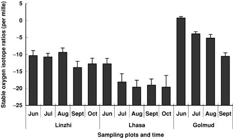
δ18O values for summer precipitations in the three plots on the Tibetan Plateau.
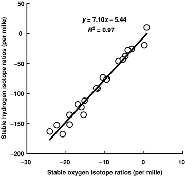
Meteoric water line for precipitations of the sampling plots on the Tibetan Plateau.
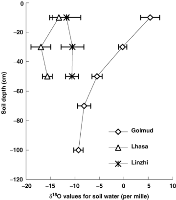
Spatial distribution of mean soil water δ18O in the three plots on the Tibetan Plateau (the data were from all the samples in this study, n = 25).
However, marked variations for δ18O values of different depths of soil water were observed in the Golmud plot (Figure 3). δ18O values were higher for surface soil water than those of deep soil water. Moreover, surface soil water had a greater extent of δ18O values than deep soil water did in all of the sampling times (data not shown). δ18O values for soil water below 60 cm were relative constant with the changes of soil depth and the sampling times. Stable isotope values of soil water at 100 cm depth remained constant during the whole summer, and were very similar to those of groundwater (1.7 m in the plot; δ18O = −9.47 ± 0.16‰, n = 10).
δ18O values for plant xylem water in the Golmud plot were less negative than those in the Lhasa and Linzhi plots (Figure 4). Salix rehderiana had the smallest xylem water δ18O values among the four species (Figure 4B). δ18O values of Nitraria tangutorum xylem water were constant in the whole growth season and very similar to those of the deep soil water (Figure 4A). δ18O values of plant xylem water were different obviously for the two dominant species in Linzhi plot (Figure 4C). δ18O values for xylem water of Pinus tabulaeformis varied greatly, while those of Quercus aquifolioides were relatively constant among different months.
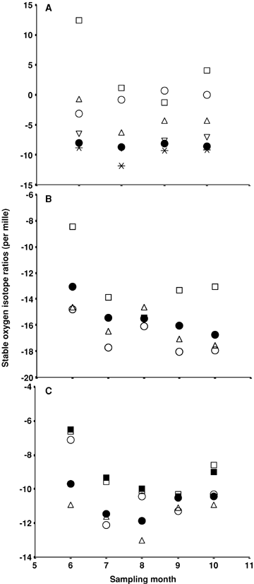
Stable oxygen isotope ratios of plant xylem water (closed symbols) and soil water (open symbols) in Golmud (A), Lhasa (B) and Linzhi (C) in the summer of 2005.( •) Nitraria tangutorum in Golmud, Salix rehderiana in Lhasa and Quercus aquifolioides in Linzhi. (▪) Pinus tabulaeformis in Linzhi. 10 cm (□); 30 cm (○); 50 cm (▵); 70 cm (▿);100 cm (*).
Water sources for the plants
No river or stream water, even ephemeral runoff water could be found in the Golmud plot due to the small annual precipitation in the area. Deep soil water and groundwater were regarded as one potential water source of plants in the Golmud plot because of their very similar stable isotope ratios. For the same reason, we treated precipitation and surface runoff water as one potential water source of plants in the Linzhi and Lhasa plots.
Water used by plants was mainly derived from deep soil in the Golmud plot. Precipitations had small contributions to plant growth in the plot. Plant xylem water was completely from deep soil water in June when monthly precipitation was only 1.4 mm. However, more than 40% of the plant xylem water was derived from rainwater when precipitation amounted to 23.4 mm in July.
Just as in the Golmud plot, plants mainly used the water from deep soil in the Lhasa plot. More than half of plant xylem water was derived from rainwater when precipitation was 104.3 mm in July. A larger rainfall in August caused floodplains in the river near the sampling plot. Plants were inundated on the sampling day and plant xylem water was completely derived from precipitation in the plot. However, mean rainwater use ratios were only 28.2% in June, July and October when precipitation was accidentally small.
The two dominant plants in the Linzhi plot used different water sources although they grew in the same area. Q. aquifolioides mainly used the water from deep soil, however, most of plant xylem water for P. tabulaeformis was derived from precipitation. A total of 87.2% of the plant xylem water of Q. aquifolioides was derived from soil water in the growth season on average. Only 10.5% of xylem water of Q. aquifolioides was from precipitations in July, September and October. The increase of precipitation promoted rainwater use ratios for Q. aquifolioides. In June and August when precipitation was relatively large, 30.5% and 43.2% of xylem water were from rainwater, respectively. While for P. tabulaeformis, more than 75% of xylem water was derived from rainwater during the growth season. On average, 92.5% of plant xylem water for P. tabulaeformis was from precipitation from June to October in 2005.
All of the plants used a mixture of soil water and precipitations in present study. The rapid switch among different water sources was observed for all of the plants when environmental water conditions changed. Our results indicated significant differences among species in the uptake of summer precipitations (Table 1). Rainwater use ratios increased with an increased amount of precipitation for all four plants (Figure 5).
| Plots | Dominant species | Percentage of plant xylem water from precipitation (%) | ||||
|---|---|---|---|---|---|---|
| Jun. | Jul. | Aug. | Sept. | Oct. | ||
| Golmud | Nitraria tangutorum | 0a | 42.6a | 17.2a | 9.1a | no data |
| Lhasa | Salix rehderiana | 36.6b | 51.1a | 100.0b | 36.4b | 21.4a |
| Linzhi | Quercus aquifolioides | 30.5b | 11.9b | 43.2c | 10.3a | 9.2a |
| Pinus tabulaeformis | 100.0c | 100.0c | 100.0b | 84.2c | 78.1b | |
- a, b, c, dSignificant difference in the same column. n = 10. P < 0.05.
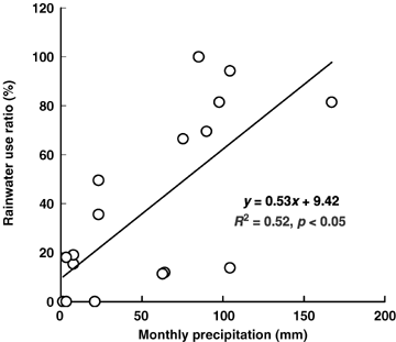
The relationship between precipitation and the percentage of plant xylem water derived from rainwater on the Tibetan Plateau.
Discussion
Variations of stable isotope ratios for summer precipitations were caused mainly by different water vapor sources and weather conditions on the Tibetan Plateau (Tian et al. 2001). Precipitations experienced vapor coagulation, water evaporation, elevation change and many other physical and chemical processes, which strongly influenced hydrogen and oxygen isotope fractionation (Yan et al. 1998). Different water sources had distinct isotopic signatures due to their different water circle patterns (Burgess et al. 2000). These variations provide the basis for quantitative determinations of different water sources used by plants (White et al. 1985; Brunel et al. 1995).
We found that water penetrating to deep soil layers was more depleted in the heavier isotopes than surface soil water in the Golmud plot. In addition, stable isotope ratios of surface soil water varied wildly among different months, whereas those of deep soil water were maintained constant and similar to those of groundwater. We believe that unlike stable isotope values of surface soil water, which were strongly influenced by precipitations and evaporation, stable isotope values of deep soil water were influenced mainly by groundwater.
Spatial and temporal variations of water sources for different plants were obvious, especially for the plants in arid areas (Gregg 1991). Diversity of root distribution caused broad variations in plant water sources and water uptake models (Pennuelas et al. 1999). Many plants in the arid and semiarid zones had dimorphic root systems: surface roots potentially took up water from growth season precipitations, while deeper roots extracted water in the deep soil that was recharged from last winter and spring precipitations (Williams and Ehleringer 2000). The surface roots were inactive in droughty seasons (Flanagan et al. 1992), while deep roots kept active to extract soil water during the time when the precipitations were unreliable (Ehleringer and Dawson 1992). All of the plants except P. tabulaeformis in the present study used water mainly from deep soil when precipitation was relative small. However, a rapid switch to surface soil water use was observed in the plants when precipitation increased, which perhaps promoted the activity of plant surface roots (Williams and Ehleringer 2000). All of the four dominant plants on the Tibetan Plateau switched to use greater amounts of rainwater when precipitation increased. Local water conditions caused by variations in annual precipitations perhaps have important influences on the zonal vegetation distribution on the Tibetan Plateau.
River water was not always the optimal water source for riparian species (Dawson and Ehleringer 1991; Smith et al. 1991; Muttiah et al. 2005), which was also confirmed by our result that intermittent water from the rivers near the sampling plots were not the main source for S. rehderiana in the Lhasa plot and Q. aquifolioides in the Linzhi plot. Use of groundwater or deep soil water was helpful for plants to survive water deficiency in arid areas (Shi et al. 2003). Broad-leaved and coniferous species had different water sources, although they were in the same area. A possible explanation is that there is a significant difference in rooting patterns and root activity. For example, Meinzer et al. (2001) showed that competition for limited soil water during the dry season could be reduced by species-specific differences in leaf phenology as well as differences in rooting patterns and root activity.
From ecophysiological studies, it is clear that some species may positively respond to shifts of precipitation patterns and some others may respond negatively, which will cause changes in plant community structure in this region (Lin et al. 1996; Weltzin and McPherson 1997). Our results showed that there were different water use sources for plant species with different life forms in the Linzhi plot. This implied that different species responded differently to changes of precipitation patterns. However, only one dominant species was concerned in the two ecosystems in Golmud and Lhasa plots, considering the economy and huge work of sampling and measuring. Therefore, it is necessary to carry out research on water sources for more key species in these ecosystems. It will be helpful for us to fully understand the response of species to ongoing climate changes, and to analyze changes of vegetation distribution in the future.
The Tibetan Plateau has been experiencing warming and drying since the 1950s (Zheng et al. 2002). That would have a strong influence on the plants that use water mostly from precipitation, such as P. tabulaeformis in the Linzhi plot. Changes in precipitation distribution have fewer effects on the plants that mainly depend on groundwater and deep soil water. These plants have a greater possibility to survive and thrive in the future when decreasing local precipitation occurs.
Materials and Methods
Study areas
As a result of the interference of the north-west monsoon from the Indian Ocean, the rainy season begins from the south-east to the north-west on the Tibetan Plateau. Annual precipitation decreases gradually from the south-east to the north-west, 70–90% of which is concentrated in summer, from June to September. Annual precipitation is less than 50 mm in the north, whereas it is up to 500 mm in the south of the Tibetan Plateau.
A comprehensive investigation was conducted in the summer of 2004, mainly focusing on vegetation distribution in the typical ecosystems. Three plots (100 m × 100 m), uniform in species composition and cover, were established on the Tibetan Plateau based on previous investigation, which consisted of a gradient of mean annual precipitation (Figure 6). These plots have been little interfered by human activities. We also considered the feasibility and convenience for sampling on the Tibetan Plateau. The dominant species in each plot are presented in Table 2.
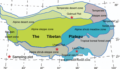
The location of study sites on the Tibetan Plateau.
| Vegetation type | Dominant species | Location | Elevation (m) | Mean temperature (°C) | Annual precipitation (mm) | |
|---|---|---|---|---|---|---|
| Golmud | Desert shrub | Nitraria tangutorum | 36°2450.3′E, 94°5635.4′N | 2 973 | 6.6 | 42 |
| Lhasa | Alpine shrub | Salix rehderiana | 29°4038.5′E, 91°1910.9′N | 3 674 | 9.3 | 496 |
| Linzhi | Tropical rain forest | Quercus aquifolioides and Pinus tabulaeformis | 29°1337.3′E, 94°1355.7′N | 2 958 | 9.8 | 552 |
Sample collecting
On the 15th and 30th day of each month from June to October in 2005, plant stem and soil samples were collected in three plots. The effects of interferences on stable isotope composition were eliminated by maintaining consistent collecting samples.
Plants with intermediate size classes (about 10 cm basal diameter) were selected to avoid the possibility of juvenile or senility effects. Suberized twigs, approximately 0.2 cm in diameter, were cut from sunlit branches in the middle of plant canopies at midday. The twigs were immediately enclosed in screw-cap glass vials, which were sealed using parafilm for subsequent analysis of hydrogen and oxygen isotope ratios (δD and δ18O). For each species, five plants were sampled repeatedly.
Soil samples were collected using a hand auger from 10, 30, 50, 70 and 100 cm depths in each plot. However, soils deeper than 70 cm in the Lhasa and Linzhi plots were not collected owing to the underlying rock. Soil samples were separated into two parts: one was sealed in glass vials for isotopic analysis of soil water; the other was sealed in soil tins for subsequent analysis of gravimetric water content (percentage water, measured as g water/g soil).
Precipitation was collected twice a month in each plot, one during the 1st to 15th day and the other during the 16th to 0th day of each month, respectively. Stream water was collected in the Lhasa and Linzhi plots and groundwater was collected in the Golmud plot on each sampling day. It was impractical to obtain groundwater in the Lhasa and Linzhi plots and stream water in the Golmud plot.
Samples were collected at the same time among the three plots. All of the water, plant, and soil samples were kept in a dry cooler until transfer to the lab for analysis of isotope ratios.
Analysis, calculation and statistics
Water was extracted from plant xylem and soil samples using cryogenic vacuum distillation in the stable isotope laboratory in the Institute of Botany, the Chinese Academy of Sciences (Ehleringer and Osmond 1989). Hydrogen and oxygen isotope ratios (δD and δ18O) for all of the samples were analyzed on a Finnigan Delta-S isotope ratio mass spectrometer (Finnegan MAT 253, Institute of Geographical Sciences and Natural Resources Research, CAS).
 (1)
(1) (2)
(2) (3)
(3) (4)
(4) (5)
(5)Errors from sample collecting, transporting and analyzing may have resulted in negative values for water use ratios by plants. Those values were set to zero, indicating that plants didn't use the source at the time. If stable isotope ratios of plant xylem water did not differ from those of water sources all of the time, the use ratios of the source by plants was set to 100, indicating that water used by plants was derived from the source completely.
Meteorological data including air temperature and precipitation were collected from local weather stations of the China Meteorological Administration (CMA). Data were subjected to anova followed by Duncan's multiple range test. Simple linear regression analysis was also carried out. Correlation coefficients (r) were verified at the P < 0.05 levels.
(Handling editor: Jian-Xin Sun)


