Humus on the Rocks—Water Storage Capacity of Tangelhumus is Essential for Water Retention in Limestone Mountains
Academic Editor: Hermann Jungkunst
Funding: This research was supported by the Waldklimafonds of the German Bundestag, Project No. 22WC406302.
1 Introduction
Rock-humus soils are found primarily in mountainous areas, where they are an important part of the soil landscape. Since they often only occur in small areas, their importance is frequently underestimated on large-scale maps. For example, this soil class is not shown at all on the 1:1,000,000 scale soil map of Europe (Panagos 2006), not even in mountainous regions. This is despite the fact that in the Bavarian Alps, rock-humus soils account for around 10% of the landscape (Olleck et al. 2021; cf. Figure 1). In the Polish part of the Tatra Mountains, a proportion of approximately 3.5% has been reported (Stolarczyk et al. 2024). In addition, the pedological classification of rock-humus soils is not straightforward. In the WRB classification system, they are largely classified as Folic Histosols, but can also be found within the group of Leptosols (Leitgeb et al. 2013). National classification systems often vary considerably in how they categorise these soils. In Bavaria, for example, they can be found under the designations Felshumusböden (rock-humus soil) and O/C-Böden (O/C soil; O for organic, C for parent material of soil development) (LfU 2017). What all rock-humus soils have in common is that their ecology is determined exclusively by the humus layer. It serves as the only rooting zone, nutrient store and water store. If the humus layer disappears, bare rock remains. Due to their unique formation conditions, the properties of the humus layers over rock differ significantly from those of typical humus layers of mineral soils. For this reason, they are classified in a separate humus class, which is widely referred to as Tangelhumus (Kolb and Göttlein 2021). In the Bavarian Alps, Tangel-humus preferentially forms over solid or coarse carbonate rocks with low residual clay content and can reach a thickness of more than 100 cm. It is mainly found in the montane to subalpine zone of the Limestone Alps, where a cool and humid climate favours the accumulation of organic matter (Kolb and Kohlpaintner 2018). However, such humus layers can be found not only on calcareous but also on acidic bedrock, showing expected differences in pH and cation composition at the contact zone with the respective bedrock (Stolarczyk et al. 2024; Kolb and Göttlein 2022). In addition to chemical properties, understanding the water storage capacity of Tangelhumus is crucial, both for estimating the water supply of the trees and for assessing the landscape water regimes. Extensive tables are available for the water storage capacity of mineral soil horizons, differentiated by texture, bulk density and humus content (AK Standortskartierung 2016). However, such values are not available for Tangelhumus horizons. Therefore, pF curves were derived for Tangelhumus horizons of the Bavarian Limestone Alps, which allowing for quantification of the storage potential for plant-available water (plant available water capacity, PAWC) and the total water retention (field capacity, FC).

2 Material and Methods
In the Bavarian Limestone Alps, three sites with Tangelhumus were sampled (Figure 1). The Simetsberg site, a mixed mountain forest (beech, spruce, maple, fir), is located in the Werdenfelser Land near lake Walchensee at an altitude of 927 m. The pure Norway spruce stand Lange Au is situated in the Mangfallgebirge close to lake Tegernsee at 943 m asl. In the Berchtesgadener Alpen, the Lattenberg site is a Norway spruce forest at 1436 m asl. The bedrock of Simetsberg and Lange Au is dolomite (Hauptdolomit) and that of Lattenberg is limestone (Dachsteinkalk).
The pF curves were determined using the HYPROP and WP4C analysers from METER (Munich). The HYPROP method is based on the evaporation method according to Schindler (1980). The measuring range was extended by Schindler et al. (2010) and ranges from water saturation to near the permanent wilting point (pF 4.2). Values around and above pF 4.2 were measured with the WP4C dew point potentiometer. For the analyses, undisturbed sample cylinders (diameter 8 cm, height 5 cm) were taken from Tangelhumus horizons, each with a volume of 250 cm3.
Sampling proved challenging, as obtaining intact sample cylinders from the often densely rooted Tangelhumus profiles is difficult. The measurement of the water tension curve with HYPROP typically took between 15 and 22 days, with some samples requiring up to 38 days. During this time, continuous contact between the shrinking sample and the built-in minitensiometer had to be maintained, and if contact was lost the measurement and sample were discarded. On average, the total processing time for a single sample required 3–4 weeks.
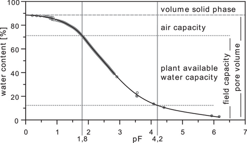
In the laboratory, samples were fully saturated with water and placed in the HYPROP system. Measurement progress was monitored, and data were recorded using the HYPROP-View software (METER). The pF curves were modelled by integrating the WP4C measurements with the HYPROP-FIT software (METER; Pertassek et al. 2015) using the ‘unconstrained van Genuchten-Mualem’ method.
To estimate the importance of the humus layer to the landscape water budget, a simple model based on the method proposed by Haude (1952) was used to calculate the evapotranspiration of a virtual coniferous stand on humus layers of different thickness using the formulae and tables given in BGR (2000). Although the Haude method is easy to use and requires only few input data, it gives quite good results (DVWK 1996). Meteorological data from the Mittenwald-Buckelwiesen weather station (station number 3307) near the Simetsberg site were used to run the model on a daily basis. For this station, the German weather service (DWD) provides quality-controlled open data for the years 1937–2022 (https://opendata.dwd.de). To represent the range of possible water balances, the years with the warmest (2003), driest (1947), coolest (1974) and wettest (1966) growing seasons (May–October) were selected for analysis.
3 Results and Discussion
Figure 2 shows the modelled water tension curve and the characteristic values derived for an Oh horizon. The values for all measured samples are listed in Table 1. Total pore volume (TPV) ranges between 80.5% and 89.9% and air capacity (AC) between 17.4% and 30.2%. FC ranges from 56.3% to 71.9% and PAWC from 40.6% to 59.8%. At the Simetsberg site, all relevant Tangelhumus horizons could be sampled. However, there was no clear trend in the measured values with developing humification from Of to Oh to Ovh. Deviations within a horizon (measured for Oh) and between sites were generally greater than differences due to humification. Thus, the mean values given in Table 1 provide a good estimate of the water-holding capacity across an entire Tangelhumus profile.

|
Location Horizon |
Total pore volume (TPV) | Air capacity (AC) | Plant available water capacity (PAWC) | Bound water (BW) | Field capacity (FC) |
|---|---|---|---|---|---|
| Simetsberg | |||||
| Of/Oh (3–8 cm; BD = 0.121 g/cm3) | 87.3 | 20.1 | 54.5 | 12.7 | 67.2 |
| Oh (10–15 cm; BD = 0.160 g/cm3) | 86.1/89.5 | 23.3/30.2 | 49.1/45.9 | 13.7/13.4 | 62.8/59.3 |
| Ovh (18–23 cm; BD = 0.174 g/cm3) | 87.6/88.2 | 20.7/21.3 | 51.0/49.4 | 15.9/17.5 | 66.9/66.9 |
| Lange Au | |||||
| Oh (7–12 cm; BD = 0.142 g/cm3) | 88.6 | 17.4 | 58.9 | 12.3 | 71.2 |
| Oh (13–18 cm; BD = 0.144 g/cm3) | 82.1 | 19.7 | 48.3 | 14.1 | 62.4 |
| Ovh (19–24 cm; BD = 0.161 g/cm3) | 89.9 | 18.0 | 59.8 | 12.1 | 71.9 |
| Lattenberg | |||||
| Oh (15–20 cm; BD = 0.177 g/cm3) | 86.4/86.5 | 21.1/21.4 | 49.1/49.9 | 16.2/15.2 | 65.3/65.1 |
| Oh (20–25 cm; BD = 0.187 g/cm3) | 83.5 | 22.5 | 45.8 | 15.2 | 61.0 |
| Oh/Ovh (33–38 cm; BD = 0.178 g/cm3) | 80.5 | 24.4 | 40.6 | 15.7 | 56.3 |
| Mean ± SD | 86.4 ± 2.9 | 21.7 ± 3.3 | 50.2 ± 5.4 | 14.5 ± 1.7 | 64.7 ± 4.6 |
| for comparison | |||||
| silt (Uu TRD 3)a | 45 | 7 | 26 | 12 | 38 |
| raised bog peat (z3 SV3)b | 93 | 20 | 60 | 13 | 73 |
Compared to silt, the mineral soil with the highest PAWC, Tangelhumus horizons have a TPV nearly twice as high, a PAWC more than twice as high and a much higher AC. Only raised bog peat exhibits higher values than Tangelhumus (Table 1). However, the measured values for the Ovh-horizon at Lange Au come very close to the values reported for raised bog peat.
The very high water storage capacity can lead to water stagnation, particularly in the Ovh-horizon, during the heavy precipitation events typical for the Alpine region. This effect is likely intensified by an additional capillary barrier at the transition to the underlying parent material. The resulting temporary oxygen deficiency, combined with the rather cool temperatures, leads to impaired decomposition conditions and could therefore be an important stabilising factor for Tangelhumus layers.
Using the average values for each site from Table 1 and the average Tangelhumus thickness at each site, the storage capacity for plant available water can be estimated (Table 2). These high values ensure a good water supply for the forest stand and a high storage capacity during heavy rainfall events. However, climate change, with rising temperatures, fewer wet periods and persistently high nitrogen inputs, promotes mineralisation and thus leads to a gradual degradation of Tangelhumus (Gangkofner and Göttlein 2014). This degradation of humus reduces the available rooting space of humus-dominated forest sites, reduces their water-holding capacity and, in extreme cases, even harms their forest viability.
| Location | Thickness (cm) | PAWC (mm) | FC (mm) |
|---|---|---|---|
| Simetsberg | 52 | 260 | 336 |
| Lange Au | 36 | 201 | 247 |
| Lattenberg | 37 | 172 | 229 |
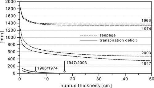
Estimating the water budget based on humus layer thickness with a simple model (Figure 3) reveals some interesting aspects. When evapotranspiration of the stand no longer can be satisfied by the plant available water of the humus layer, the model computes a transpiration deficit. For the warmest and driest year as well as for the coldest and wettest year, the calculated curves of transpiration deficit are very close together. The arrows given in Figure 3 indicate the humus thickness below which the model calculates seven or more consecutive days of water deficit for the stand. Due to the high PAWC of Tangelhumus, in combination with high precipitation in the Bavarian Alps in cold and wet years, 6 cm of humus is enough to provide the stand with water. In warm and dry years, at least 17 cm is needed. Over the long term, this implies that stands with a humus thickness below 17 cm are susceptible to drought, and that the thinner the humus layer, the lower the chance of forest survival. This threshold value of about 17 cm is supported by unpublished data from a study where we measured humus thickness in 24 forested Tangelhumus sites, spruce forests and mixed mountain forests, in Allgäu, Werdenfelser Land, Mangfallgebirge and Berchtesgadener Alpen regions, totalling 344 measurements. Only two measurements, 12 and 16 cm, were lower than the above-mentioned threshold. Lower values, however, are found in degrading forests.

Figure 3 also shows the estimated seepage depending on humus thickness. In cool and wet years, seepage remains nearly constant down to a humus thickness of about 6 cm, because water loss by evapotranspiration is quickly compensated by precipitation and the humus layer remains saturated most of the time. In warm and dry years, seepage gradually increases from 50 cm down to 6 cm thickness, because the humus storage capacity is not fully used, and as a consequence seepage becomes dependent on humus thickness. Below 6 cm, seepage increases dramatically as humus thickness decreases towards 0 cm, because finally there is no longer any humus to store water or vegetation to utilise it through evapotranspiration. Transforming a humus rock soil into bare rock results in a fast and nearly quantitative seepage of every rain event. Comparing seepage at 17 cm humus, the thickness at which a mountain forest can just about survive also in dry years, with a completely degraded site (0 cm humus) for all four modelled years there is a dramatic increase in seepage of more than 500 mm. For comparison, this value is about the total annual precipitation of Würzburg (1971–2000: 583 mm; Würzburg-Heidingsfeld; open data DWD).
4 Importance on the Landscape Level
As shown in Figure 1, the proportion of forests growing on Tangelhumus ranges from 5% to 19%, with the lowest value in Allgäu and the highest value in the Berchtesgadener Alpen. The vitality of forests on Tangelhumus is therefore of great importance for water retention in the landscape. If these forests are threatened by disasters such as windthrow, bark beetle or the degradation of Tangelhumus due to a warming climate, their protective functions against avalanches and rockfall can, at least partially, be compensated by technical measures such as avalanche barriers or rockfall fences. However, there is no feasible technical substitute for their role in water retention.
Acknowledgements
The study was carried out as part of the ‘Alpenhumus’ project (funding reference: 22WC406302) funded by the German Federal Government's Forest Climate Fund (Waldklimafonds).
Open access funding enabled and organized by Projekt DEAL.
Open Research
Data Availability Statement
Data sharing not applicable to this article as no datasets were generated or analysed during the current study.


