Facies analyses and depositional setting of the Lower Cretaceous Shurijeh–Shatlyk formations in the Kopeh Dagh–Amu Darya Basin (Iran and Turkmenistan)
Abstract
The Lower Cretaceous siliciclastic fluvial to shallow marine Shurijeh–Shatlyk formations together form one of the main reservoir successions in the Kopeh Dagh–Amu Darya Basin (NE Iran, Turkmenistan, and north of Afghanistan). Sedimentary facies and thickness changes in the Shurijeh–Shatlyk formations show complex variations throughout the basin, which highlight the importance of understanding the controlling factors on facies distribution and depositional setting for future hydrocarbon exploration. Integration of 3D seismic data, 13 boreholes, and five surface stratigraphic sections led to identification of lithofacies and facies associations. The results allow subdivision of this siliciclastic succession into four stratigraphic units (A, B, C, and D). Our study indicates that base-level changes interacted with palaeotopography inherited from Middle Jurassic basin rifting, Upper Jurassic carbonate reefs/patch reef distributions, and reactivation of the deep basin faults, to control the Shurijeh–Shatlyk depositional setting and sedimentary facies distribution. Our findings show that the Aghdarband and Badkhyz–Maimana palaeo-highs affected the Kopeh Dagh–Amu Darya Basin throughout deposition of the Shurijeh–Shatlyk formations. Allogeneic processes and active tectonics, related to the Valanginian Late Cimmerian Orogeny, caused a base-level fall, exposure of Upper Jurassic carbonate sediments, and deposition of a carbonate pebbly conglomerate unit in the western part of the study area. This base-level fall led to the deposition of thick evaporites in the western area and conglomerate in the eastern parts of the Kopeh Dagh. Due to a Hauterivian sea-/base-level rise, several deltas formed in the basin, which form the main reservoir zone in the Murgab Depression and Khangiran Field in Turkmenistan and Iran.
1 INTRODUCTION
The Kopeh Dagh–Amu Darya Basin (KDADB) is one of the most important hydrocarbon (mostly gas) provinces in the world (Kryuchkov, 1996; Ulmishek, 2004). This basin hosts several giant and small gas fields such as Galkynysh (the largest gas field in the basin), Dauletabad, Shaltyk, Khangiran, and Gonbadli (Figure 1a: Afshar-Harb, 1979; Kavoosi, Lasemi, Sherkati, & Mossavi-Harami, 2009; Klett et al., 2006; Moussavi-Harami & Brenner, 1992; Ulmishek, 2004). The KDADB formed after closure of the Palaeotethys Ocean between Eurasia and Gondwana during the Cimmerian Orogeny (Brunet et al., 2017; Garzanti & Gaetani, 2002). The Palaeotethys suture zone forms the southern basin boundary (Brunet et al., 2017; Robert et al., 2014; Sheikholeslami & Kouhpeyma, 2012; Stocklin, 1977; Wilmsen, Fürsich, Emami, Majidifard, & Taheri, 2009) which is exposed in north-east Iran and north Afghanistan (Figure 1b).
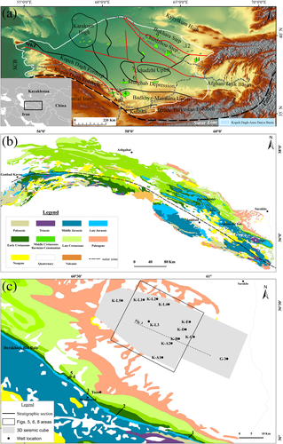
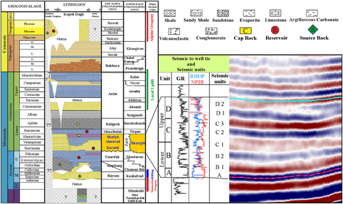
Relatively continuous deposition of sedimentary rocks in the KDADB began during Middle Jurassic rifting near the Pamir region (Figure 1a), in the east to the Caspian Basin to the west of the study area and continued through to Miocene time (Klett et al., 2006; Moussavi-Harami & Brenner, 1992; Ulmishek, 2004). However, there are several hiatuses within the Cretaceous–Palaeocene succession in the south-western part of the basin (Figure 2, and see Brunet et al., 2017; Robert et al., 2014). Based on depth-structural and isopach maps (Brunet et al., 2017), depocentres in the KDADB are mostly oriented WNW–ESE. Compression occurred during the Alpine Orogeny and closure of the Neotethys Ocean during Neogene–Quaternary time (Robert et al., 2014). The resultant folded and thrusted sediments form several NW–SE trending anticlines and synclines in the basin that are exposed in north-east Iran and Turkmenistan (Figure 1).
Upper Jurassic carbonates and Lower Cretaceous non-marine strata form the main gas reservoir zones in the KDADB (Afshar-Harb, 1969, 1982; Kavoosi, Lasemi, Sherkati, & Mossavi-Harami, 2009; Kryuchkov, 1996; Moussavi-Harami & Brenner, 1990; Ulmishek, 2004). Some small oil fields have been explored in the eastern part of the basin, which produce from Upper Cretaceous and Palaeocene reservoirs (Klett et al., 2006; Ulmishek, 2004). Hydrocarbons are mainly generated from Upper Bajocian to Bathonian shales of the Kashafrud Formation and probably from Middle Jurassic shales and marls of the Chaman Bid Formation in the Kopeh Dagh (Kalantari, 1987; Robert et al., 2014; Saadati et al., 2016) and Middle Jurassic shale and coals in the Amu Darya (Ulmishek, 2004). Hydrocarbon reservoirs in eastern Kopeh Dagh are genetically thermogenic (Saadati et al., 2016).
The Lower Cretaceous succession is known as the Shurijeh Formation in Iran and the Karabil, Almurad, and Shatlyk formations in Turkmenistan and Afghanistan (Afshar-Harb, 1979; Brookfield & Hashmat, 2001; Klett et al., 2006; Moussavi-Harami & Brenner, 1992, 1993; Ulmishek, 2004; Figure 2). In this study, we use both equivalent formations together (Shurijeh and Shatlyk [instead of Karabil, Almurad, and Shatlyk]) to avoid the complexity of different formation names in Iran and Turkmenistan. Lower Cretaceous siliciclastic reservoirs contain more than 50% of the gas reserves in the basin and are the main reservoir zones in the Dauletabad, Shaltyk, Malay, Chartak, Bayram-Ali, Khangiran, and Gonbadli fields (Afshar-Harb, 1979; Kryuchkov, 1996; Pashayev, Gavril'cheva, & Redzhepov, 1993; Ulmishek, 2004). The upper part of the Shurijeh–Shatlyk formations (Hauterivian) is the reservoir zone in most of these fields, especially in the Murgab Depression (Figure 1) where 90% of explored gas reserves produce from these sandstones (Kryuchkov, 1996; Ulmishek, 2004). The Lower Cretaceous succession forms two distinct reservoir zones in the giant Khangiran Gas Field of the Kopeh Dagh, NE Iran. The Shurijeh–Shatlyk succession in the KDADB consists of fluvial, deltaic, and shallow marine lithofacies. This succession overlies the Upper Jurassic (calcareous) Mozduran Formation in the Kopeh Dagh Foldbelt and evaporites (Gaurdak Formation) in the central and eastern parts of the KDADB (Figure 2; Afshar-Harb, 1982; Kavoosi, 2014; Moussavi-Harami & Brenner, 1990; Ulmishek, 2004).
The Shurijeh–Shatlyk formations were deposited after a widespread marine regression during Late Jurassic–Early Cretaceous times. Sedimentary facies distributions in these formations show variations from mixed siliciclastic–evaporites in the east (north Afghanistan, Uzbekistan, and Turkmenistan) to non-marine siliciclastics in the south (East Kopeh Dagh Foldbelt) and siliciclastic–evaporites–carbonate in the west (near Khor and Hamam-Ghaleh). Any prediction of reservoir potential depends on developing and understanding of the controlling factors on facies distribution and depositional setting of the reservoir rocks. Hence, this research aims to understand the palaeo-environmental setting and sedimentary facies variations in the Lower Cretaceous sequence in the basin, focusing on the eastern Kopeh Dagh Foldbelt where an extensive subsurface data and outcrops are available.
2 GEOLOGICAL SETTING
Subsidence in the KDADB began along ENE–WSW longitudinal faults during the Middle Jurassic (Afshar-Harb, 1982; Brunet et al., 2017). Synrift sediments rest with an angular unconformity on Devonian to Triassic sedimentary and arc, back-arc volcanic rocks, which are exposed in the Aghdarband erosional window (eastern Kopeh Dagh Foldbelt), as well as north of Afghanistan (Brookfield & Hashmat, 2001; Ruttner, 1991, 1993; Zanchetta et al., 2013). The synrift succession consists of conglomerate, sandstone, siltstone, shale, and coal-bearing rocks (the Kashafrud–Baysun formations). The Upper Bajocian to Tithonian shale and argillaceous limestone (Chaman Bid Formation) covers the Kashafrud–Baysun formations on the central and western parts of the Kopeh Dagh Foldbelt (Afshar-Harb, 1979; Kalantari, 1987). The Upper Bajocian to Tithonian Chaman Bid succession formed in the deeper parts of the platform. This formation is present in the Khangiran Field and pinches out towards the Gonbadli and south of the gas fields along the outcrop belt in the Mozduran Range.
Upper Jurassic carbonates of the Mozduran–Kugitang formations rest unconformably on the Kashafrud–Baysun formations (Bajocian to Callovian) in eastern and southern parts of the basin. These carbonates pass laterally into coastal siliciclastic sediments towards the basin margin and palaeo-highs such as the Aghdarband erosional window towards the south-east (Kavoosi, Lasemi, Sherkati, & Mossavi-Harami, 2009; Moussavi-Harami & Brenner, 1992; Zand-Moghadam, Moussavi-Harami, Mahboubi, & Aghaei, 2016). In the Murgab Depression and eastwards of the basin, Callovian–Oxfordian carbonate rocks (Kugitang Formation) are overlain by thick evaporites of the Kimmeridgian–Tithonian Gaurdak Formation (Klett et al., 2006; Ulmishek, 2004). Thin anhydrite layers of Gaurdak Formation are present in the Gonbadli Field but are absent in the western and southern parts of the basin as well as the Khangiran Field.
The non-marine Shurijeh–Shatlyk formations were deposited after a Late Jurassic-Early Cretaceous regional marine regression, due to closure of the central Iran and Helmand basins during the Late Cimmerian Orogeny (Brunet et al., 2017; Golonka, 2004; Thomas, Cobbold, Shein, & Le Douaran, 1999). These formations rest with erosional contact on the Mozduran and Gaurdak formations and gradually change upward to the Barremian carbonate rocks of the Tirgan and Okuzbulak formations (Figure 2). The Shurijeh–Shatlyk siliciclastic facies were deposited in a fluvial setting in the lower part and fluvial to shallow marine environments in the upper part of the formation (Afshar-Harb, 1969; Klett et al., 2006; Mortazavi, Moussavi-Harami, & Mahboubi, 2013; Moussavi-Harami & Brenner, 1992, 1993; Ulmishek, 2004). Generally, the thickness of Shurijeh–Shatlyk formations increases to the Kopeh Dagh Foredeep and varies from ~40 m in the Nar (near the Aghdarband erosional window) to more than 1,000 m in the Khor and Hamam-Ghaleh areas; but this thickness variation is not continuous. To the west of the Kopeh Dagh Foldbelt, the thickness of the Shurijeh–Shatlyk formations decreases and gradually changes to marine calcareous and argillaceous carbonates of the Zard Formation. In addition, in some regions such as north of Afghanistan, the Murgab Depression, and in the Afghan-Tajik Basin, the thickness of the Shurijeh–Shatlyk sequence decreases where it is deposited in lagoonal to deltaic and continental environments (Klett et al., 2006; Kryuchkov, 1996; Pashayev, Gavril'cheva, & Redzhepov, 1993; Ulmishek, 2004).
Although there are limited studies on the sedimentological characteristics of the Shurijeh–Shatlyk formations, particularly in the eastern part of the basin (Turkmenistan, Uzbekistan, and Afghanistan), recent studies on the Kopeh Dagh Foldbelt have indicated that the Shurijeh–Shatlyk formations were deposited in arid to semiarid climatic conditions in palaeolatitudes of about 30° to 40° N (Fursich, Brunet, Auxie'tre, & Munsch, 2015; Mortazavi, Moussavi-Harami, Brenner, & Mahboubi, 2013; Moussavi-Harami, Mahboubi, Nadjafi, Brenner, & Mortazavi, 2009; Thomas, Cobbold, Shein, & Le Douaran, 1999). In addition, Moussavi-Harami and Brenner (1990) suggested that the siliciclastic sediments of the Shurijeh Formation have metamorphic, igneous and sedimentary sources that derived from south and south-west of Mashhad (i.e., north-east Iran).
3 METHODS AND MATERIALS
The study area is located in the eastern Kopeh Dagh Foldbelt, north-east of Iran (Figure 1). In this study, we used 1,000-km2 3D of time-migrated seismic data, subsurface data from 13 wells and five surface measured stratigraphic sections (Figure 1c) to analyse the depositional setting of the Shurijeh–Shatlyk formations in the KDADB.
In order to interpret and map the subsurface geological features within the siliciclastic succession, a 3D seismic cube with 25 × 25-m bin size (acquired during two seismic surveys in late 1990s and early 2010s) was interpreted. Eight horizons were identified on seismic data throughout the Shurijeh Formation (Figure 2). Interpretation of seismic data provides amplitude variations, which depends on rock properties. Three-dimensional seismic data interpretation involves extracting time slices and horizontal slice in plan view, providing map views over geological time for the analysis of ancient buried geomorphological surfaces (Brown, 2011; Chopra & Marfurt, 2007; Davies, Posamentier, Wood, & Cartwright, 2007; Posamentier & Kolla, 2003). Beyond classic seismic stratigraphy and vertical seismic section analysis, horizon slices (cuts through a seismic data cube) from tracking seismic horizons have been used for the interpretation of channels and other geological features. The relevant attributes such as seismic amplitude, coherency, instantaneous spectral decomposition (based on continuous-wavelet transforms [CWTs]), and RMS (root mean square) attributes have been extracted along the interpreted horizons for evaluation of geological features and their lateral and vertical variations.
To interpret the subsurface data in the drilled wells, we reviewed 50 boreholes and then selected 13 wells for detailed analysis. Wireline logs used in this study include gamma ray (GR), spontaneous potential (SP), resistivity (LLD), density (RHOB), sonic (DT), and neutron logs (NPHI). In addition, we used cutting samples in every 1 m (in some cases 30 cm) from the Shurijeh Formation in all of the studied wells as well as core data of five wells including KB, KC, KD, KL4, and G3 wells (Figure 1c).
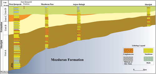
As outlined above, the Shurijeh Formation is exposed in the south of study area (Figure 1) and, hence, is an ideal location for field observations. In this study, we measured and sampled five stratigraphic sections (from east to west) including the Shurijeh Village, Anjeer-Bulagh, Mozduran Pass, East Qorqoreh, and West Qorqoreh (Figure 1c). Note that the thickness of the Shurijeh Formation from the east to the west is 92, 143, 190, 217, and 286 m, respectively. In the field, sedimentary facies, facies associations, and architectural elements have been identified based on lithology, primary sedimentary structures, unit geometry, and the nature of bedding contacts with adjacent units.
4 RESULTS
Moussavi-Harami and Brenner (1990) subdivided the Shurijeh Formation into three distinct portions based on lithostratigraphy. Unit A (the lower unit) consists of shale with thin- to medium-bedded and planar cross-stratified sandstone, which changes upward to thick-bedded and cross-stratified conglomerate, with minor amounts of cross-stratified pebbly sandstones and mudstone. Unit B (the middle unit) is composed of fine- to coarse-grained cross-stratified and parallel-laminated pebbly sandstone with minor mudstone. Unit C, the uppermost unit consists of a fining-upward sequence beginning with conglomerate and sandstone, followed by silty and gypsiferous shale.
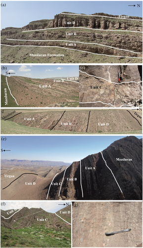
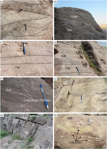
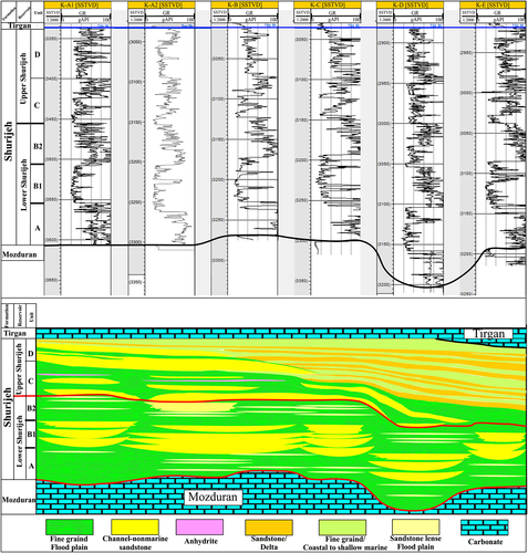
Our stratigraphic analyses, based on surface and subsurface data, indicate that the conglomerate facies recorded at the base of the upper unit by Moussavi-Harami and Brenner (1990) comprises a unique sedimentary component, distributed throughout much of the study area both in outcrop and subsurface (i.e., the gas fields; Figures 3-6). These conglomerates are mostly composed of carbonate pebbles and quartz (Figure 3g), with the former derived from Upper Jurassic Mozduran Formation (Moussavi-Harami & Brenner, 1990). The conglomerate fines upward and grades to thin-bedded fine-grained sandstone, mudstone, and shale. This unit is mostly present in the western portion of the study area and is absent eastward in the Mozduran Pass. However, two thin layers (20 to 30 cm thick) of the carbonate pebbly conglomerate are also present in the Anjeer-Bulagh (Figures 3c and 4). Northward in the Khangiran Field, carbonate pebbly microconglomerate and sandstone facies are present and pinch out to the east towards the Gonbadli Field. The upper part of this unit is composed of shale, claystone, and siltstone, and there is a thin anhydrite layer present at the top in the Khangiran Field (Figure 6). In the following sections, lithofacies and facies associations are described.
4.1 Lithofacies
The Shurijeh Formation, in the eastern Kopeh Dagh, is mainly composed of milky white quartzose conglomerate, sandstone, and shale. Texturally, the polymictic conglomerates are poorly sorted, with sub-angular to rounded grains. Clasts are mainly quartz, but some metamorphic, igneous, and sedimentary fragments are also present. The sandstones are commonly cross-stratified in the lower parts, while it is thick to massive in the upper part with the presence of palaeosols and bioturbation. In our analyses, based on primary sedimentary structures, texture, internal bedding architectures, and grain compositions, we identified 11 terrigenous and three non-terrigenous lithofacies in the Shurijeh Formation including terrigenous coarse-grained (conglomerates), medium-grained (sandstones), fine-grained (mud rock and shales), and non-terrigenous palaeosols, anhydrite, and siliciclastic-carbonate hybrid lithofacies. Field photos, description, and interpretation of each lithofacies are briefly presented in Table 1 and Figure 5. Petrographic analyses of conglomerates and sandstones in various facies show that they have a similar bulk composition dominantly mono- and poly-crystalline milky white quartz, metamorphic, chert, and igneous rock fragments, and feldspars, except a carbonate pebbly conglomerate facies (Gch).
| Code | Facies | Description | Interpretation |
|---|---|---|---|
| Gt | Complex trough cross-stratified conglomerate | Grains are sub-rounded to round that mostly are quartz. Form lenses with lower erosional surface. | Deposition in longitudinal barriers in fluvial systems (Miall, 1985) |
| Gm | Massive grain-supported conglomerate | Clast-supported, sandy conglomerate with clast of granular to cobbles size. Commonly massive but may have diffused horizontal bedding. Bed thickness is irregular following the topography of the erosion surface below. | Deposition by high-energy currents same as debris flow in deeper parts of channels (Bridge, Alexander, Collier, Gawthorpe, & Jarvis, 1995; Köykkä, 2011; Miall, 2006) |
| Gp | Planar cross-stratified conglomerate | Clast-supported sandy conglomerate with clast of 2 mm to 5 cm. clasts are sub-rounded. Thickness of the cross-bedded sets are 10 to 40 cm. | Deposition in effect of migration of cross tongue bars in braided fluvial systems (Miall, 1985) |
| Gch | Horizon-stratified carbonate pebbly conglomerate | Grains are mostly composed of sub-rounded micritic carbonate pebbles and quartz, which stratified horizontally in middle Shurijeh F. | Deposition by high-energy currents in longitudinal barriers in channels |
| Gh | Horizon-stratified conglomerate | Grains are mostly composed of sub-rounded quartz, igneous and metamorphic rock fragments and chert. Mostly with normal graded bedding. | Deposition in longitudinal barriers with low sinuses channels (Miall, 1985). |
| Sm | Massive sandstone | Fine to medium grain size. Some parts changed to pebbly sands. Include calcrete and palaeosols horizons. Trace fossils are abundant. | Deposition by high sedimentation rates and sudden decrease in discharge (Owen, 1996; Røe, 1987). |
| Sp | Planar cross-stratified sandstone | Medium to coarse sands with low angle planar bedding. | 2D sandy dunes and simple bars (Cant & Walker, 1978). |
| Sh | Horizontally laminated sandstone | Medium to coarse sand that may change to pebble size. Thickness of layers change from 10 cm to more than 1 m and laterally extent to several hundred metres. | Deposition in flood plain of channels (Khalifa & Catuneanu, 2008; Miall, 2006). |
| Fhiss | Horizontally interbedded silts and sands | Interbedded of thin layers of fine grain sandstone and siltstone. Mostly in upper parts of sequence. | Low-lying wetlands on the floodplain with variable drainage conditions (Miall, 1985). |
| Fl | Laminated claystone and siltstone | Grey to brown-grey laminated claystone and siltstone associated with shales and sandstones. | Deposited as suspended sediments in floodplain at the end of flooding stages. |
| Shale | Shale | Green and purple alternates of shale that repeated. Mostly present in top of the sequence. Interbedded gypsum shale deposited in ponded water in the gas field area. | Deposition in flood plain, marine environments, or coastal plain. |
| Pc | Palaeosol | This facies change from calcite nodules to continuous and continues horizons with thickness ranges from 10 cm to maximum 1 m. | Calcretes formed in arid to semiarid climatic conditions mostly through evaporation, degassing with no biological activity in vadose and phreatic (Moussavi-Harami, Mahboubi, Nadjafi, Brenner, & Mortazavi, 2009). |
| Hybrid | Sandy limestone | Clasts are floated in carbonate mud, which is neomorphed during diagenesis. Quartz is the main clast. | These facies are associated with shale and Fl and present in top of formation, which deposited in coastal plain. |
| And., Gyp. | Anhydrite and Gypsum | This microfacies includes white to light grey nodular and layers of anhydrite and gypsum. | Deposited in abounded channels in floodplain on the Khangiran Gas Field. |
4.2 Facies association
We subdivided the Shurijeh Formation into four facies associations based on specific depositional settings including: (1) multi-storey, fluvial channel; (2) single-storey, fluvial channel; (3) floodplain; and (4) coastal to shallow marine.
4.2.1 Multi-storey, fluvial channel
Description
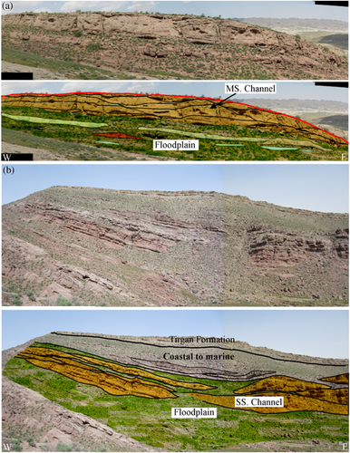
This facies association is made up of lenticular poorly sorted conglomerate bodies, which extend laterally for tens of metres. Lower and upper contacts of the bodies are erosional which laterally change to a high-relief erosional surface (Figure 7a). Clast sizes range from 4 to 16 cm, which are floating in a medium- to coarse-grained sandy matrix. The conglomerate beds are composed of massive, cobble-supported conglomerates (Gm), horizontal stratified conglomerates (Gh and Gch), trough cross-stratified conglomerates (Gt), planar cross-stratified conglomerates (Gp), massive sandstones (Sm), and rarely horizontal stratified sandstones (Sh; Figure 5). Internally, these lithofacies show a well-defined fining-upward succession. The thickness of this facies association varies from less than 1 to 15 m in the study area. To the north (Khangiran Field) and downstream, the conglomeratic facies laterally changes to dominantly medium- to coarse-grained sandstone and siltstone lithofacies that are shown by a blocky motif in GR logs in the lower part of the Shurijeh Formation (Figure 6).
Interpretation
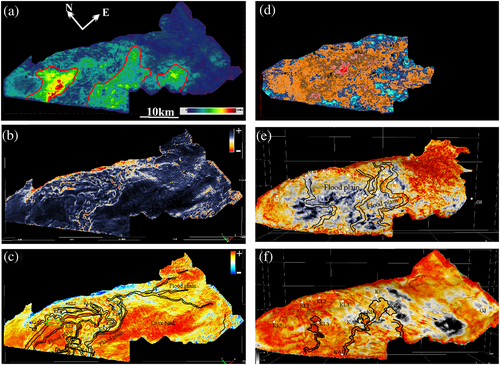
Facies analysis indicates that large-scale fining-upward cross-strata and horizontal cross-strata, bounded by erosive surfaces, may have been deposited during migration of sand bars downstream and are associated with vertical aggradation in fluvial channels (Bridge, 1993; Jo & Chough, 2001;Miall, 2014; Scherer, Goldberg, & Bardola, 2015). Stratified conglomerates can be formed during migration of longitudinal bars in low sinuosity gravelly fluvial channels (Jo & Chough, 2001; Therrien, 2006). The thick-bedded to massive clast-dominated conglomerates with irregular and poorly sorted clasts can be interpreted as high-strength turbulent flow deposits. Coarse-grained facies, multi-storey conglomerates, and sandstone bodies and downstream accretion of macroforms along the outcrop suggest that deposition may have taken place in a low-sinuosity braided fluvial system. Seismic geomorphological maps and the blocky motifs of GR logs in the Khangiran Field (Figures 6 and 8b,c) suggest that this facies association is deposited in a braided multichannel fluvial system.
4.2.2 Single-storey, fluvial channel
Description
This facies association consists mostly of fine- to medium-grained sandstones, including thick to massive bedded (Sm), horizontal bedded (Sh), planar cross-stratified (Sp), and trough cross-stratified (St) sandstone lithofacies (Figures 5 and 7b). There are trough cross-stratified intraformational conglomerates (Gt) at the basal erosional surface of sandstone bodies. The sandstone bodies reached up to 10 m with limited lateral accretion. The lenticular sandstone facies contain calcareous palaeosols (Figure 5e) and bioturbation in the upper parts of the formation. The single-storey fluvial channel deposits formed thick lenticular sandstone bodies along the outcrop belt in upper parts of the Shurijeh Formation.
Interpretation
The lenticular sandstones with basal erosional surface and unidirectional palaeocurrents can be interpreted as a fluvial channel system (Miall, 2014). Limited lateral accretion with vertical aggradation suggests low sinuosity channels with relatively low lateral migration (Miall, 2014; Scherer, Goldberg, & Bardola, 2015). Analysis of the equivalent horizons on seismic data and attribute maps in the Khangiran Field shows low-sinuosity rivers at that time (Figure 8e). Note that point bars were not developed and channel migration is limited throughout deposition. In addition, the occurrence of calcretes in the sandstone facies reveals water table fluctuation and formation of calcretes in vadose and phreatic phases in fluvial systems (Miall, 2014; Moussavi-Harami, Mahboubi, Nadjafi, Brenner, & Mortazavi, 2009).
4.2.3 Floodplain
Description
The reddish claystone, thin to massive mudstone, and shale are the main lithofacies in this association. Thickness and distribution of these facies vary throughout the succession and ranges from 50 cm up to 4 m in the study area. Shales in the lower parts are argillaceous, while in the upper part are gypsiferous green and purple. Fine-grained sandstones with horizontal lamination and siltstones are present. Note that calcrete is observed in some fine-grained sandstone and siltstone facies in the Shurijeh Formation. Thicknesses increase from outcrop in the south to the Khangiran Field in the north, where thin gypsum and anhydrite layers are recorded in boreholes (Figure 6). The lithofacies of this association are mostly associated with single-storey fluvial channel association.
Interpretation
The occurrence of reddish fine-grained lithofacies associated with thin sandstone facies and palaeosols is interpreted as a floodplain deposit. The reddish colour and occurrence of calcretes indicate oxidation and development of palaeosols in arid to semiarid climatic conditions (Ghazi & Mountney, 2011; Jo & Chough, 2001; Moussavi-Harami, Mahboubi, Nadjafi, Brenner, & Mortazavi, 2009; Scherer, Goldberg, & Bardola, 2015). The floodplain was expanded during deposition of the lower and upper Shurijeh Formation in the gas fields. However, thickness, distributions, and association with single-storey fluvial channel show that expansion of the floodplain was much wider during deposition of the upper parts of the Shurijeh Formation (Figures 6 and 7).
4.2.4 Coastal plain to marine
Description
The dominant lithofacies of this association are well-sorted, cross-stratified, and horizontal laminated sandstones and mixed siliciclastic–carbonate lithofacies. They are deposited at the top of the Shurijeh Formation (Figure 7b). Thickness of the sandstone units vary from 30 cm to 1 m. Mixed siliciclastic–carbonate facies are mainly present in the Khangiran Field; however, only a few thin layers (40 cm) have been identified along the outcrop to the south. This facies association contains a coarsening-upward sandstone–shale (from borehole cuttings) and well-log motif in the Khangiran Field (Figure 6). In addition, a thin carbonate layer is present in upper Shurijeh to the west of the Khangiran Field.
Interpretation
An association of cross-stratified or laminated fine-grained sandstone lithofacies, as well as siltstone, mudstone, and silty to clayey gypsiferous shale (at top of channel sandstones), and the presence of the mixed siliciclastic–carbonate facies, in outcrop and subsurface, are interpreted as coastal to shallow marine environments. In addition, analyses of seismic attributes revealed the expansion of the marine environment and occurrence of deltaic system (Figure 8) that will be discussed below.
4.3 Palaeotopography
Relative sea-level fall during the Late Jurassic–Early Cretaceous led to progradation of the shoreline to the north-west–west of the KDADB (Brunet et al., 2017; Golonka, 2004; Thomas, Cobbold, Shein, & Le Douaran, 1999; Ulmishek, 2004). This widespread regression resulted in the exposure and erosion of some parts of the basin that had a major impact on deposition and distribution of sedimentary lithofacies in the study area. Correlation of the Shurijeh succession along the outcrop belt shows that there had been two palaeo-high surfaces at the base of the Units A and C (Figure 4). As seen in Figures 4 and 9a, the thickness of the Shurijeh succession decreases to the east–south-east, towards the Aghdarband erosional window, where some parts of the Upper Jurassic–Lower Cretaceous rocks have been eroded. A decrease in the thickness of Shurijeh Formation to the east indicates that the Aghdarband area formed a local high during deposition of the Shurijeh–Shatlyk formations. Seismic data and attribute maps reveal the distribution of a fluvial system and irregular palaeotopography at the base of the Shurijeh Formation (Figure 8). Based on seismic and stratigraphic data, the thickness of the Shurijeh–Shatlyk sequence decreases towards the east–south-east to less than 40 m at the Nar section. This evidence further supports our interpretation that the palaeo-highs were present during deposition of the Lower Cretaceous deposits to the south and east in the Aghdarband erosional window, as well as the Badkhyz–Maimana high areas.
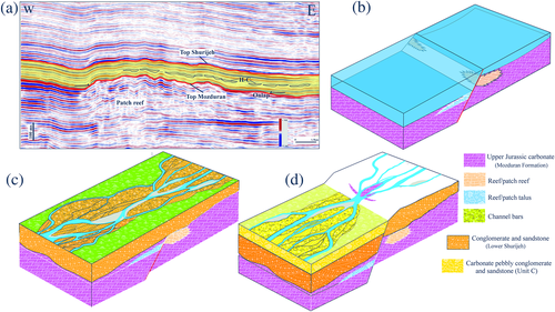
The main fluvial channel belt in the Unit A of the Shurijeh Formation is coincident with the Upper Jurassic patch reefs in the Khangiran Field and outcrop (Figure 9a). The distribution of patch reefs and their interaction with the erosional processes influence the Lower Cretaceous channels distribution that will discussed below. For example, stratigraphic analyses of the East and West Qorqoreh sections show remarkable differences in thickness (about 60 m) over an area of less than 1 km.
The second uplift occurred at the base of the Unit C, where erosion of the carbonate deposits occurred during deposition of the carbonate pebbly conglomerate of Unit C (Figures 4 and 8). Petrographic studies indicate that carbonate pebbles were mainly derived from the Mozduran Formation in the south. Analyses of boreholes and seismic data indicate that the carbonate pebbly conglomerate/microconglomerate fluvial channel facies is absent in the Gonbadli Field. In addition, the interpreted channels on the seismic attributes and well logs in the Khangiran Field show variable distribution and flow direction of the channels in relation to the Units A and B during deposition of the pebbly conglomerate facies (Figure 8). Hence, most parts of the study area (Gonbadli Field and eastern Mozduran Pass) were exposed during this time.
5 DISCUSSION
During deposition of the synrift Kashafrud–Baysun formations (Middle Jurassic), a marine environment was established to the east–south-east of the basin (Brunet et al., 2017; Poursoltani & Gibling, 2011; Poursoltani, Moussavi-Harami, & Gibling, 2007; Ulmishek, 2004). Then, a carbonate platform formed during the Late Jurassic, where a semicircular barrier reef complex formed on the eastern and central parts of the basin (from Chardzhou to the west and south-west; see fig. 7 in Ulmishek, 2004). Patch reefs were identified in the Khangiran Field and along the outcrop belt to the south (Figure 9a). The back reef (carbonate shelf) was separated on the northern and western parts from deep marine facies towards the south and south-east (to the north of Afghanistan) by the barrier reefs (Ulmishek, 2004). In the Kopeh Dagh and Dauletabad ranges, thick, shallow back-reef carbonate rocks were deposited during Oxfordian to Tithonian time (Kavoosi, 2014; Kavoosi, Lasemi, Sherkati, & Mossavi-Harami, 2009; Lasemi, 1995; Mahboubi, Moussavi-Harami, Carpenter, Aghaei, & Collins, 2010). At the same time, the carbonate facies changes to siliciclastic coastal and delta facies towards the basin margins and palaeo-highs, such as the Aghdarband area (Zand-Moghadam, Moussavi-Harami, Mahboubi, & Aghaei, 2016). Carbonate facies deposition continued until the Tithonian and probably to the Early Cretaceous in the Kopeh Dagh Foldbelt (Kavoosi, Lasemi, Sherkati, & Mossavi-Harami, 2009; Mahboubi, Moussavi-Harami, Carpenter, Aghaei, & Collins, 2010; Zand-Moghadam, Moussavi-Harami, Mahboubi, & Aghaei, 2016). While in the Murgab Depression, the Callovian to Oxfordian shallow carbonate facies was overlaid by the thick salt–anhydrite of the Gaurdak Formation (Ulmishek, 2004). As stated, the Upper Jurassic carbonates and evaporites are overlain by continental deposits of the Shurijeh (in the Kopeh Dagh) and Karabil (in the Amu Darya) formations. The age of the boundary between marine and continental deposits is not recognized, precisely, but the generally accepted age is Tithonian–Berriasian based on ostracods, foraminifers, and algae from carbonates of the lagoonal and shallow marine deposits (Jamali, 2011; Kim, Salimova, Abduasimova, & Meshchankina, 2007; Mortazavi, 2013). Therefore, it is not recognized which part of the basin (Kopeh Dagh or Amu Darya) was exposed, initially. Herein, in the southern parts of the basin, we divided the Shurijeh succession into two parts (lower and upper Shurijeh) for better understanding of the depositional history of this reservoir formation and are discussed as follows:
5.1 Lower Shurijeh
During the Late Cimmerian Orogeny (Late Jurassic–Early Cretaceous), most parts of the KDADB were exposed to erosion (Brunet et al., 2017; Klett et al., 2006; Siehl, 2015; Ulmishek, 2004). Our studies and previous studies of palaeocurrent analyses by Jamali (2011) and Mortazavi (2013) indicate that in Early Cretaceous times, rivers flowed from the south and south-east towards the north and north-west in the study area. In addition, some data such as depth-structure, isopach maps, and cross-sections (Brunet et al., 2017), increases the proportion of quartz with respect to other detrital grains the east to the west in the Kopeh Dagh Foredeep (Ulmishek, 2004), uplift in the northern Afghanistan and Uchadzhi area (Klett et al., 2006; Siehl, 2015), and northward decreases of grain size in the north Afghanistan (Brookfield & Hashmat, 2001) support our interpretation that the main fluvial direction in the Amu Darya Basin was from the east–south-east towards the west–north-west during Early Cretaceous time. On the other hand, thinning of the shallow marine carbonate deposits of the Mozduran, as well as siliciclastics of the Shurijeh Formation to the east in the easternmost parts of the Kopeh Dagh Foldbelt, indicates that the Aghdarband erosional window was a palaeo-high during the Late Jurassic–Early Cretaceous. Moreover, westward-trending channels in the Gonbadli Field and stratigraphic variation of the Shurijeh–Shatlyk deposits on the eastern Kopeh Dagh Foldbelt reveal a direct link between the Aghdarband palaeo-high and Badkhys Uplift in a short period of time during Late Jurassic–Early Cretaceous.
In addition, and as can be seen in Figure 9a, the main channel belt is located on carbonate build-ups in the Khangiran Field. Interaction between erosional processes and carbonate sediments resulted in the distribution of fluvial channels between patch reefs. The location of the rift system in the KDADB is poorly understood, due to deep burial faults which have been locally distinguished on seismic data (Robert et al., 2014). Seismic profiles reveal that the formation and development of carbonate build-ups are related to Mid-Jurassic basin rifts. However, the presence of reefs in the outcrops and subsurface suggests that they formed at the top of horst blocks of rifting systems (Figure 9b). It is also possible that atoll reefs (as reported from deeper part of the basin by Ulmishek, 2004) developed on the horst blocks in the north of Afghanistan.
Furthermore, based on seismic attribute analyses in the Khangiran Field, the main palaeocurrent direction had changed to north–north-west in the downstream area (Figures 8b and 3c). Our study shows that some channels on the Gonbadli Field (Figure 8c) flowed from the east to the west (from the Badkhyz Uplift towards the Gonbadli and Khangiran). Sharp changes of channel strike both in the Khangiran and Gonbadli fields can be related to the impact of the Ashgabat Fault (MKF), which was probably active at that time (Brunet et al., 2017; Noemani Rad, Gharabeigli, & Soleimany, 2016).
5.2 Upper Shurijeh
Changes from the lower to the upper Shurijeh are very abrupt in the eastern side of the study area (Mozduran Pass and its eastern side). The base of the upper Shurijeh Formation can be placed at the carbonate pebbly conglomerate (on outcrop) to microconglomerate (in the Khangiran Field). As outlined in the previous sections, the carbonate pebbles originated from the older stratigraphic sequences (Mozduran Formation). Towards the east, along the outcrop belt, Unit C pinches out in the Mozduran Pass; however, a very thin horizon of carbonate pebbly microconglomerates (Unit C about 20 to 50 cm) appears in the Anjeer-Bulagh section (Figures 3, 4, and 6). This indicates major depositional changes that led to erosion and, locally, deposition of the underlying sediments.
Jamali (2011) suggested that the coastal to shallow marine sandstones of the Unit D in eastern part of the Kopeh Dagh Foldbelt laterally change to the Valanginian–Hauterivian carbonate and Hauterivian clastic units in the Hamam-Ghaleh area. This marine transgression resulted in the deposition of the carbonate member (Early Hauterivian) of the Almurad Formation (VZG, 2004) in western Turkmenistan. The Valanginian–Hauterivian carbonates overlie a thick evaporite unit in the Hamam-Ghaleh area. There is an evaporite unit present between two carbonate units which indicates sea-level fall during the Early Cretaceous time in this area. According to the correlation by Jamali (2011), the relative sea-/base-level fall in the Hamam-Ghaleh is similar to the study area which led to exposure of the basin before/during deposition of the Unit C. Therefore, erosion of the Upper Jurassic carbonates resulted in the formation of the carbonate pebbly conglomerates of the Unit C in the Shurijeh Formation.
As mentioned earlier, deposition of the Shurijeh Formation is mainly controlled by Middle Jurassic basin rifts and fault displacement in the basin. A possible scenario for the local deposition of carbonate pebbles in the Shurijeh Formation is the reactivation of normal faults in the eastern Kopeh Dagh Foldbelt (Figure 9b,d). Based on this interpretation, faulting could have led to a base-level fall and exposure of Upper Jurassic carbonates on the footwalls and deposition of conglomerates in the downstream area (hanging walls; Figure 9b,d). Therefore, tectonic activity during (Early?) Valanginian time may have affected the KDADB and led to deposition of coarse clastic rocks. This sea-/base-level fall could be controlled by allogeneic parameters, such as a major global sea-level fall, as reported by Haq, Hardenbol, and Vail (1987), Snedden and Liu (2010), and Haq (2013) during the Valanginian.
Seismic data and facies analyses show a sea-/base-level rise during deposition of the Unit D of the Shurijeh Formation (Hauterivian), where depositional systems change from fluvial to siliciclastic coastal and shallow marine environments. On the other hand, seismic data (Figure 8f) reveal a delta in the Khangiran Field (Figure 8f). Deltaic sediments have also been reported in the Shurijeh Formation from the western side of the study area (Jamali, 2011; Mortazavi, 2013). As mentioned above, the Hauterivian Shatlyk Sandstone Bed was deposited in a deltaic setting in the Murgab Depression and Dauletabad-Donmez Field (Tashliev et al., 1985; Ulmishek, 2004). The delta in the Khangiran Field is different from the Shatlyk delta, as the thickness of the Shatlyk Sandstone Bed decreases towards the Khangiran Field (to <10 m) and Khangiran delta pinches out towards Turkmenistan (Figure 8f). The Khangiran delta formed on the north slope of the Aghdarband palaeo-high and Shatlyk delta was deposited on the west–north-west side of the Badkhyz–Maimana Uplift.
6 CONCLUSIONS
The Lower Cretaceous succession (Shurijeh Formation) of the Kopeh Dagh–Amu Darya Basin can be subdivided into four stratigraphic units (A, B, C, and D). Based on lithofacies analyses, the Shurijeh Formation comprises 11 terrigenous and three non-terrigenous lithofacies, which formed four facies associations including multi-storey fluvial channel, single-storey fluvial channel, floodplain, and coastal to shallow marine associations. Our study reveals that there were two local highs (Aghdarband erosional window and Badkhyz–Maimana Uplift) during Early Cretaceous time that controlled deposition, facies distribution, and thickness variations of the Shurijeh–Shatlyk formations in the south of the KDADB.
Seismic attribute maps show that fluvial channels on the lower Shurijeh Formation follow Upper Jurassic patch reef distributions in the Khangiran Field. On the other hand, Middle Jurassic basin rifting has controlled the occurrence and distribution of these reefs/patch reefs in the basin. We suggest that the occurrence of the fluvial channels in the lower Shurijeh Formation was controlled by base-level changes, basin rifting, Upper Jurassic reef/patch reef distributions, topography, and tectonic activities of the basin.
In this study, we identified an erosional surface within the Shurijeh sequence that is related to basin fault reactivity and coincident with a Valanginian global sea-level fall. This led to the exposure of eastern–south-eastern parts of the study area and deposition of carbonate pebbly conglomerates (Unit C) along the outcrop belt and in the Khangiran Field. This base-level fall also led to deposition of thick evaporites in the central Kopeh Dagh Basin. During the Hauterivian, there was a sea-level rise that resulted in the deposition of a coastal to shallow marine siliciclastic environment in the southern and eastern parts of the basin. In addition, the main sandstone reservoir and gypsiferous shale (as a cap rock) were deposited in a deltaic environment in the Khangiran Field and Murgab Depression.
ACKNOWLEDGEMENTS
First, the authors would like to acknowledge and thanks Dr. Alastair Ruffell for his suggestions and editorial work that improved our manuscript significantly. We express our gratitude to the Exploration Directorate (NIOC) for sponsoring, data preparation, and permission to publish. We are grateful to Dr. Jalil Ghalamghash and Dr. Khalil Baharfirouzi (Geological Survey of Iran) for providing the fieldwork facilities and other logistic support. We are grateful to Dr. Maryam Mortazavi for information of the West Qorqoreh section. We also thank the Department of Geology at the Ferdowsi University of Mashhad for supporting this project (Research Project Code: 3/27868).


