The interplay between extrinsic and intrinsic controls in determining floodplain wetland characteristics in the South African drylands
Abstract
Controls on the characteristics of floodplain wetlands in drylands are diverse and may include extrinsic factors such as tectonic activity, lithology and climate, and intrinsic thresholds of channel change. Correct analysis of the interplay between these controls is important for assessing possible channel–floodplain responses to changing environmental conditions. Using analysis of aerial imagery, geological maps and field data, this paper investigates floodplain wetland characteristics in the Tshwane and Pienaars catchments, northern South Africa, and combines the findings with previous research to develop a new conceptual model highlighting the influence of variations in aridity on flow, sediment transport, and channel–floodplain morphology. The Tshwane–Pienaars floodplain wetlands have formed in response to a complex interplay between climatic, lithological, and intrinsic controls. In this semi-arid setting, net aggradation (alluvium >7 m thick) in the wetlands is promoted by marked downstream declines in discharge and stream power that are related to transmission losses and declining downstream gradients. Consideration of the Tshwane–Pienaars wetlands in their broader catchment and regional context highlights the key influence of climate, and demonstrates how floodplain wetland characteristics vary along a subhumid to semi-arid climatic gradient. Increasing aridity tends to be associated with a reduction in the ability of rivers to maintain through-going channels and an increase in the propensity for channel breakdown and floodout formation. Understanding the interplay between climate, hydrology and geomorphology may help to anticipate and manage pathways of floodplain wetland development under future drier, more variable climates, both in South African and other drylands. Copyright © 2016 John Wiley & Sons, Ltd.
Introduction
Drylands (hyperarid, arid, semi-arid and dry-subhumid regions) are characterized by net water deficits owing to low, often highly variable, precipitation and high evapotranspiration. Despite such deficits, many drylands contain perennial, intermittent (seasonal) or ephemeral rivers. These dryland rivers are maintained by discharges generated in distant, more humid uplands or by local rainfall–runoff events (Tooth and Nanson, 2011; Tooth, 2013), and depending on hydroperiods (flooding extent, depth and duration), may be associated with extensive floodplain wetlands. The morphological and sedimentary characteristics of these floodplain wetlands in drylands are very diverse and remain to be fully documented and explained (Tooth and McCarthy, 2007), particularly regarding the relative importance of extrinsic and intrinsic controls.
Limited previous work has shown that at the broadest scale, most moderate to large floodplain wetlands in drylands form and develop in response to extrinsic factors (e.g. tectonic activity, lithology, climate) that typically combine with intrinsic factors (e.g. threshold channel responses to downstream declines in discharge, stream power, and sediment transport capacity). Extrinsic controls may be associated with the development of local base levels (e.g. tectonic faulting, resistant bedrock outcrops, blocking aeolian or fluvial sedimentation) that promote low energy conditions and wetland formation in reaches upvalley (e.g. Tooth and McCarthy, 2007; McCarthy et al., 2011; Joubert and Ellery, 2013; Tooth et al., 2014). Intrinsic controls, such as river channel size decreases and sediment aggradation that occur in response to downstream declines in discharge and stream power, may promote floodplain wetlands independently of, or in association with, these broader-scale changes in local base level (e.g. Tooth et al., 2002a; Ralph and Hesse, 2010). Within these wetlands, channel and floodplain characteristics may vary widely. Many wetlands are characterized by continuous, through-going channels but others are characterized by discontinuities, with channel breakdown commonly being associated with the formation of distributary channels and/or floodouts (e.g. O'Brien and Burne, 1994; McCarthy and Ellery, 1998; Tooth et al., 2002a, 2002b, 2004, 2014; Pietsch and Nanson, 2011; Grenfell et al., 2014; Ralph et al., 2011, 2015).
While the scientific understanding of extrinsic and intrinsic controls on floodplain wetland characteristics is improving, many uncertainties remain. For instance, the combinations of tectonic, lithological, climatic and other factors that govern the thresholds between the existence of continuous, through-going channels and discontinuous channels remain poorly constrained. Attempts have been made to isolate the role of climate in driving such changes to wetland structure and functioning (e.g. Grenfell et al., 2014) but need to be supported by a wider range of case studies of wetlands in different climatic settings in order to augment empirical datasets and develop conceptual models.
As a contribution to this research effort, this paper combines new data from the Tshwane–Pienaars (pronounced TSWA-nay - PEE-nahs) floodplain wetlands with previous research from other floodplain wetlands in the South African drylands. We assess whether broad-scale differences in floodplain wetland morphological characteristics are related to climatic (aridity) gradients, whereby subhumid fluvial systems are characterized by through-going channels and sediment throughput but more arid systems are characterized by fluvial discontinuity and sediment accumulation. Hence, the aims are to: (i) describe the geomorphology of the rivers and associated floodplain wetlands in the Tshwane and Pienaars catchments; (ii) outline the extrinsic and intrinsic controls on channel and floodplain characteristics; (iii) compare these floodplain wetlands with the characteristics of other South African wetlands; and (iv) present a conceptual model highlighting the influence of variations in aridity on floodplain wetlands that may be applicable to drylands more generally. Given that future changes to drier and/or more variable climates are likely to impact significantly on drylands globally [Intergovernmental Panel on Climate Change (IPCC), 2013], such research is needed to characterize and quantify the processes determining floodplain wetland characteristics, both for scientific and applied purposes. In particular, many wetlands in drylands are key deliverers of ecosystem services [Mitsch and Gosselink, 2000; Millennium Ecosystem Assessment (MEA), 2005], and so development of more robust geomorphological data and concepts may help with the development of conservation, remediation and management policies (e.g. McCarthy et al., 2010).
Regional Setting
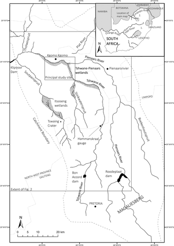
The Tshwane and Pienaars Rivers are located in northern South Africa and form part of the larger Limpopo River catchment (Figure 1, inset). Upstream of the Klipvoor Dam in the west (Figure 1), the combined catchment area is ~6940 km2. The headwaters of the Tshwane and Pienaars Rivers arise in the Magaliesberg at elevations of around ~1470 m above sea level (a.s.l.), and then both rivers flow north for ~90 km towards the towns of Kgomo Kgomo and Pienaarsrivier, respectively. The upper catchments are heavily urbanized (Greater Pretoria area). Several dams have been built for industrial, domestic and agricultural water supply, and there is substantial irrigation along the middle reaches of the Pienaars River. At Pienaarsrivier, the Pienaars River turns west (Figure 1), and then the Tshwane River joins from the south near Kgomo Kgomo. Downstream of the Tshwane–Pienaars confluence, the river is sometimes referred to as the Moretele River, but to avoid confusion, in this paper the river will be referred to as the Pienaars as far as the Klipvoor Dam (Figure 1). Near the confluence and extending downstream, extensive floodplain wetlands cover ~55 km2 (Figure 1) and are characterized by prominently leveed, meandering trunk channels, oxbows, palaeochannels and backswamps.
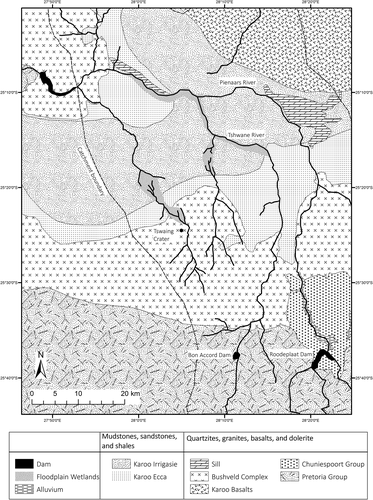
The geology of the Tshwane–Pienaars catchments comprises Pretoria Group shales and quartzites in the headwaters, with sandstones, mudstones and shales of the Karoo Supergroup (Ecca and Irrigasie Formation) in the lower reaches (Figure 2). Dolerite intrusions and granites of the Bushveld Complex (Lebowa Suite) crop out locally, particularly in the middle reaches and approaching Klipvoor Dam (Figure 2).
Climate in the area is characterized by distinct wet (November through March) and dry (April through October) seasons. Mean annual precipitation (MAP) is ~585 mm, falling mostly in the wet season during convective thunderstorms, whilst mean annual potential evapotranspiration (MAE) is ~1750 mm [Working for Wetlands, 2008; Gauteng Department of Agriculture and Rural Development (GDARD), 2011]. The aridity index is 0.33, as defined by MAP/MAE [United Nations Environment Programme (UNEP), 1992]. Despite urban and agricultural developments in the catchments, discharges in the Tshwane and Pienaars Rivers remain perennial, albeit strongly seasonal (Figure 3). During the wet season, the floodplains of both rivers are inundated by overbank flows and local rainfall, while during the dry season, low flows are confined to the main channel and many backswamps, oxbows and abandoned channels slowly desiccate.
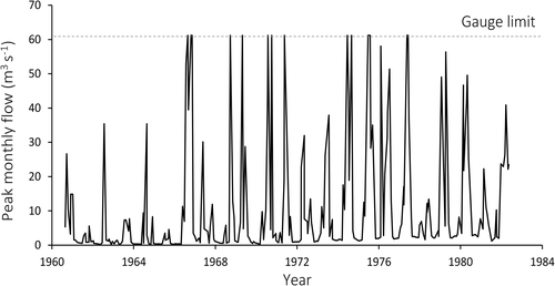
Given the depth to groundwater throughout much of the Pienaars catchment (>10 m), little to no base flow in the river can be attributed to groundwater [Department of Water Affairs and Forestry (DWAF), 1999]. Sewage discharge and irrigation returns likely have increased base flows in both the Tshwane and Pienaars Rivers, however, as seen on the Tshwane where there is evidence for a slight increase in dry season base flow over the 1961 to 1982 interval (Figure 3). There are no measured sediment transport data, but the quartzites and granites in the headwaters and middle reaches of the rivers break down to supply predominantly fine-grained material (e.g. minor gravel, sand, silt, and clay) to reaches farther downstream.
Natural vegetation in both catchments is dominated by grassland, mixed bushveld, and open woodland. Hillslopes flanking the floodplain wetlands support shrubs and trees (e.g. Senegalia mellifera, Acacia tortilis, Colophospermum mopane). In floodplain wetland areas, the dominant vegetation is grasses (Setaria incrassate, Ischaemum afrum) and exotic willows (Salix spp.) on the channel banks, with reeds (Phragmites spp.) and bulrushes (Typha spp.) characterizing backswamps with near-permanent standing water and regularly flooded palaeochannels and oxbows. Locally, water lilies (Nymphaea spp.) occupy open standing water in oxbows and palaeochannels.
The principal study site is located in the lower reaches of the Tshwane River and extends downstream along the Pienaars River until ~10 km upstream of Klipvoor Dam (Figure 1). The floodplain wetlands in these reaches are important waterbird habitats and have been minimally altered by weirs or other flow control structures (Marais and Peacock, 2008). Despite likely poor water quality entering the wetlands and some subsistence cattle grazing, the wetlands are in good geomorphological condition. There is no evidence of the deeply entrenched channels or gullies that in some other South African catchments provide evidence for base-level controlled channel incision (e.g. Keen-Zebert et al., 2013) or significant human impacts (e.g. Boardman et al., 2003).
One aim of this study is to assess the influence of climate on floodplain wetland characteristics, so it is important to place the Tshwane–Pienaars wetlands in their broader catchment and regional context. Consequently, additional investigations focussed on two other wetlands in the Tshwane-Pienaars catchment; the wetlands on the Stinkwaterspruit tributary (upstream catchment area ~ 165 km2) and the Itsoseng wetlands on the Soutpanspruit tributary (upstream catchment area ~ 120 km2) (Figure 1). Both wetlands are characterized by discontinuous channels and floodouts (here comprising unchannelled floodplains and reedswamps) and their investigations provide a basis for comparison with the characteristics of the Tshwane and Pienaars floodplain wetlands.
Methods
The Tshwane–Pienaars floodplain wetlands were investigated using aerial photographs, satellite imagery, geological maps, and field surveys. Recent (2012) aerial photographs at 1:30 000 scale provided the basis for detailed mapping of geomorphological features, such as palaeochannels, oxbows, alluvial ridges, knickpoints and backswamps. The mapping framework was based on a hierarchical system developed for floodplain wetlands in Australia by Hesse and Ralph (2011): ‘landforms’ are grouped by their dominant processes of formation and modification (e.g. fluvial, aeolian, lacustrine, anthropogenic), and ‘landform types’ comprise the landforms (e.g. palaeochannel, oxbow, alluvial ridge). In addition to mapping, morphological analysis was used to define downstream channel and floodplain trends. Using standardized methods for both rivers, quantified characteristics included floodplain width, channel sinuosity, bankfull channel width, number of channels, and floodplain and channel gradients.
Longitudinal profiles for the Tshwane and Pienaars Rivers were derived from 5 m contour intervals on 1:10 000 scale orthophoto maps and from georeferenced topographic data in ArcMap. Correspondence between the longitudinal profiles and local lithology was assessed using the 1:250 000 Geological Map Series (Sheet 2526 Rustenburg and Sheet 2528 Pretoria).
Topographic field surveys were conducted using an automatic level and supported by observations and descriptions of geomorphological and sedimentological features, particularly during and following a wet season flood (March 2015). Following the method of Bjerklie (2007), discharge and stream power were modelled for the rivers using remotely sensed channel morphology data. Meander wavelength, bankfull channel width, floodplain slope, and channel slope were measured using satellite imagery and orthophoto maps, and channel depth was estimated (surveyed cross-sections of the lower Tshwane River indicated an average channel depth of 1.95 m, which was used for all discharge calculations). A velocity calculation based on these morphological parameters allowed discharge and stream power to be calculated (equation based on hydraulic geometry relationships between river morphology variables, meander wavelength, channel width, channel slope, and flow velocity – see Bjerklie, 2007), and this process was completed at 1 km intervals downstream along 35 and 55 km long reaches of the Tshwane and Pienaars Rivers, respectively. As meander wavelength is a key variable in Bjerklie's (2007) method of estimating velocity, discharge and stream power, estimations could not be made where the channel is relatively straight, such as in the confined headwater reaches and the lower confined reach of the Pienaars near Klipvoor Dam. For comparison with these modelled values, discharge and stream power were also estimated for the lower Tshwane River using the Manning equation. Channel dimensions were taken from four cross-section surveys, slope was derived from orthophoto maps, and roughness was assessed by assigning Manning's n values to channels following field observations (Arcement and Schneider, 1989).
Results
Downstream changes in select channel and floodplain variables along the Tshwane and Pienaars Rivers are outlined in Table 1 and illustrated in Figures 4-11. These changes are outlined below with particular emphasis placed on describing and explaining the characteristics of the floodplain wetlands.
| Average gradient (m m−1)a | Average sinuosityb | Average floodplain width ( ± SD; km) c | Average channel width (± SD; m) d | Dominant underlying lithologye | Bed materialf | ||
|---|---|---|---|---|---|---|---|
| Floodplain (± SD) | Channel (± SD) | ||||||
| Tshwane River | |||||||
| Confined headwaters | 0.015 ± 0.009 | 0.015 ± 0.009 | 1.00–1.20 | 0.05 ± 0.09 | 20.7 ± 6.5 | Quartzite, Shale, Granite | Bedrock, sand and gravel |
| Partly confined middle reaches | 0.0048 ± 0.004 | 0.0051 ± 0.007 | 1.20–1.70 | 0.31 ± 0.29 | 19.3 ± 4.0 | Sandstone, Mudstone, Shale, Granite | Mud, sand and minor gravel – partly alluvial |
| Unconfined lower reaches (floodplain wetlands) | 0.0015 ± 0.0007 | 0.00083 ± 0.0003 | 1.50–2.70 | 1.13 ± 0.28 | 10.9 ± 1.5 | Sandstone, Mudstone, Shale | Mud, sand and minor gravel – fully alluvial |
| Pienaars River | |||||||
| Confined headwaters | 0.012 ± 0.01 | 0.011 ± 0.01 | 1.00–1.19 | 0.02 ± 0.04 | 19.7 ± 3.7 | Quartzite, Shale | Bedrock, sand and gravel |
| Partly confined middle reaches | 0.003 ± 0.002 | 0.002 ± 0.001 | 1.49–2.07 | 0.59 ± 0.52 | 14.1 ± 3.7 | Sandstone, Mudstone, Shale, Granite | Mud, sand and minor gravel – partly alluvial |
| Unconfined lower reaches (floodplain wetlands) | 0.0008 ± 0.0001 | 0.0004 ± 0.00005 | 1.71–3.60 | 1.23 ± 0.28 | 9.2 ± 1.7 | Sandstone, Mudstone, Shale | Mud, sand and minor gravel – fully alluvial |
| Lower confined reach | 0.001 ± 0.0009 | 0.001 ± 0.0009 | 1.00–1.50 | 0.19 ± 0.18 | 20.5 ± 4.0 | Granite | Bedrock, sand and gravel |
- a Floodplain and channel gradient measured using 5 m contour topographic data and measuring tool in ArcMap (elevation change/valley or channel distance).
- b Sinuosity measured along 1 km reaches of the channel (channel distance/straight line distance).
- c Floodplain width measured every kilometre downstream. Boundary between floodplain and valley hillslope estimated using topographic data derived from a 30 m digital elevation model (DEM) of the region and distinct vegetation zonation patterns (hillslope vegetation versus floodplain vegetation).
- d Bankfull channel width measured every 1 km downstream, generally focussing on straighter sections (inflection points) to avoid results being skewed by local increases in channel width at meander bends.
- e Lithologies derived from 1:250 000 geological map series (2526 Rustenburg and 2528 Pretoria).
- f Channel bed material estimations follow field observations and identification of bedrock outcrop in channels in aerial photographs.
Longitudinal profiles, and channel and floodplain characteristics
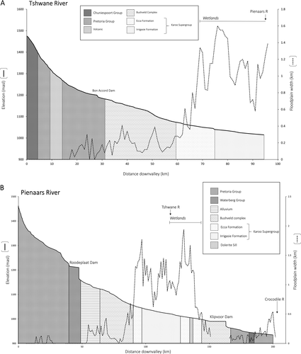
In the Tshwane and Pienaars catchments, changes in longitudinal profiles and in channel and floodplain characteristics are closely associated with lithological variations. Confined, relatively steep, straight channels with floodplains that are absent or limited in width (< 0.2 km) are generally associated with more erosion-resistant lithologies (e.g. Pretoria Group quartzites and Bushveld Complex granites) while unconfined, lower gradient, meandering channels with wide floodplains (~1–2 km) tend to be associated with the more erodible sandstones and shales of the Karoo Supergroup (Figures 4-6).
The upper ~17 km of the Tshwane River is confined and relatively steep (~0.01 m m−1), with floodplain alluvium largely absent (Figure 4A). Continuous floodplain begins farther downstream, with floodplain width increasing from <0.4 km to >1 km once the river crosses from Bushveld Complex granites to Karoo Supergroup sandstones and shales (Figure 4A). In these lower reaches, slope decreases sharply (< 0.001 m m−1). Similarly, the upper ~50 km of the Pienaars River is confined and relatively steep (~0.01 m m−1) with floodplain alluvium largely absent (Figure 4B). Downstream of Roodeplaat Dam, floodplain width widens to ~0.4 km, before increasing sharply to >1.5 km once the Pienaars River crosses from the Bushveld Complex granites to the Karoo Supergroup sandstones and shales. Floodplain gradient is very low in reaches that lie atop the Karoo bedrock (~0.0008 m m−1) but steepens significantly (~0.002 m m−1) farther downstream as the Pienaars River crosses from the Karoo sandstones to Bushveld granites. Here, there is a concomitant sharp decline in floodplain width to <0.3 km (Figure 4B).
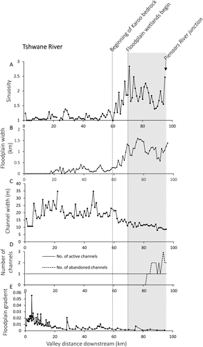
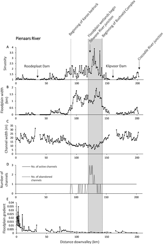
On both the Tshwane and Pienaars Rivers, channel characteristics also exhibit marked downstream changes (Table 1; Figures 5 and 6). Confined headwater reaches tend to have relatively wide (> 20 m), straight (sinuosity <1.2) channels, the partly confined middle reaches have relatively wide (> 15 m), moderately sinuous (< 2) channels, and the unconfined lower reaches have narrower (< 15 m), more sinuous (> 2) channels (Table 1). On both rivers, these marked increases in channel sinuosity and the number of sinuous abandoned channels in the middle and lower reaches (Figures 5D and 6D) indicate that the dominant forms of channel adjustment are by meander migration and channel avulsion. On the Pienaars River, the channel again becomes laterally confined downstream of the floodplain wetlands, and has a morphology similar to the headwater reaches (Figure 6).
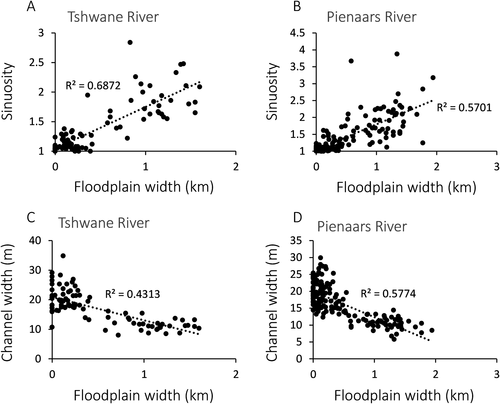
On both the Tshwane and Pienaars Rivers, there are strong positive correlations between floodplain width and channel sinuosity (Figures 7A and 7B), but strong negative correlations between floodplain width and channel width (Figures 7C and 7D). Floodplain wetlands occur where floodplain widths are greatest (up to ~2 km) and sinuosities are maximized (locally >3.5), but where channel widths are lowest (locally ~5 m). Below the Tshwane–Pienaars confluence, floodplain width and channel sinuosity both decrease once the Pienaars River starts to traverse the Bushveld Complex granites, while channel width increases once more (Figure 6).
Downstream changes in discharge and stream power
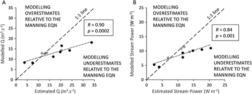
For the unconfined lower reaches of the Tshwane River, bankfull discharge and stream power were modelled by following the method of Bjerklie (2007) and also estimated using the Manning equation. Comparisons between the two sets of results reveal positive correlations (Figure 8). Despite some over- and under-estimations of the modelled discharges and stream powers relative to the Manning equation estimates, the strength of the relationship (Figure 8) indicates that similar trends will be identified with both methods.
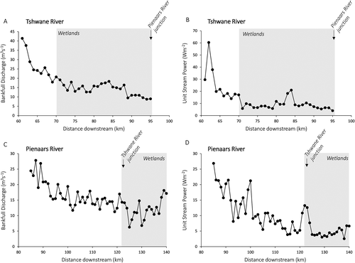
Plots of the modelled discharges show that both the Tshwane and the Pienaars Rivers experience downstream declines in discharge and unit stream power once they enter the partly confined middle and unconfined lower reaches (Figure 9). Bankfull discharge along the middle Tshwane River is initially ~40 m3 s−1 but declines to ~9 m3 s−1 by the Pienaars River junction (Figure 9A). Unit stream power follows a similar pattern, declining from between ~30 and 60 W m−2 in the middle reaches to <5 W m−2 by the Pienaars junction (Figure 9B). Along the Pienaars River, discharge decreases downstream from between ~20 and 30 m3 s−1 to between ~5 and 15 m3 s−1 (Figure 9C) while unit stream power decreases from between ~20 and 25 W m−2 to ~5 W m−2 (Figure 9D).
Channel and floodplain morphology within the Tshwane–Pienaars wetlands
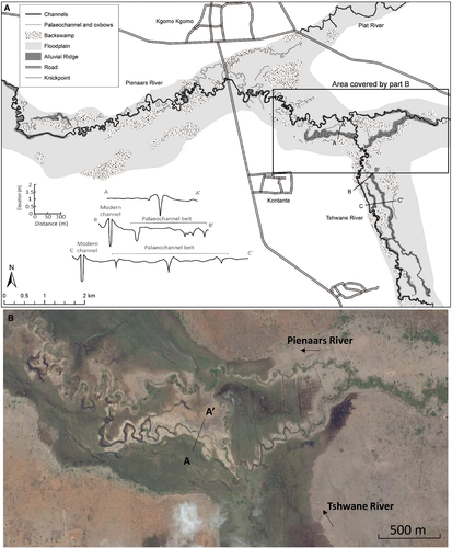
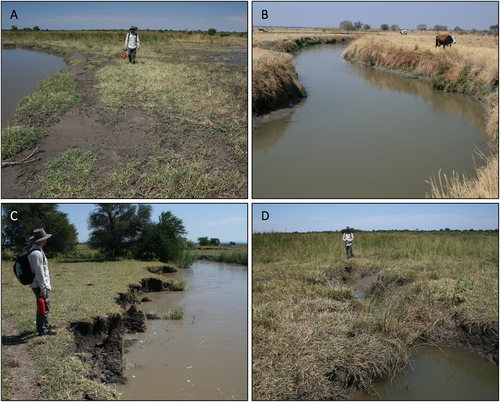
A geomorphological map (Figure 10A), and aerial and ground-level photographs (Figures 10B and 11) illustrate the range of channel and floodplain features present in the Tshwane–Pienaars floodplain wetlands. Through these wetlands, the Tshwane River decreases from ~14 m to ~9 m wide and sinuosity is variable. Relatively straight (< 1.3) reaches are separated by more sinuous reaches (> 3), with all reaches displaying prominent levees that stand up to 0.6 m above the adjacent floodplain and backswamps (Figure 10A). Numerous local cutoffs have formed oxbows and the modern channel is flanked by many straight to sinuous palaeochannels up to ~1–5 km long (Figures 10 and 11B).
This range of channel and floodplain features provides evidence for widespread lateral meander migration, active sedimentation, and channel avulsion, as was confirmed by field observations along the lower Tshwane during and following bankfull floods (March 2015). Field surveys revealed fresh vertical accretion of fine sand on levees (Figure 11A) although nowhere is there evidence for crevasse splays (Figure 10), suggesting that most medium to coarse sand and minor gravel remains within the base of the channels. Field surveys also revealed widespread evidence for oblique accretion of clay, silt, and fine sand on banks point bars and counterpoint bars. Bank collapse (toppling and slumping) was observed along straighter reaches and on concave banks (Figure 11C), and may have occurred in response to stage decreases as the steep, saturated banks collapse under their own weight. Field observations also revealed evidence for small (< 1 m high), steep knickpoints that have retreated some tens of metres headwards from the channel banks into adjacent backswamps (Figure 11D), especially on the western floodplain margin where backswamps are situated in the depression between the channel levee and the adjacent hillslope (Figures 10A and 11A). Knickpoint retreat likely occurs as overbank floodwaters drain from the backswamps to the channel after the passage of the peak floodwave. Continued knickpoint retreat may lead to formation of a new channel on a topographically-lower part of the floodplain, and ultimately may result in abandonment of an older, more elevated channel reach. Backswamps are also prominent towards the confluence with the Pienaars River, particularly where overbank floodwaters pond against a prominent (~0.5 m high) alluvial ridge that is related to a palaeochannel of the Pienaars River (Figure 10B). This ponding likely also promotes backflooding of the lower Tshwane River and may help to explain why there is no evidence for a discharge increase along the Pienaars immediately downstream of the Tshwane junction (Figure 9C). Across the floodplain wetlands generally, the fine-grained nature of overbank sediment (dominantly clay, silt, and minor sand) means that overbank floodwaters and local rainfall do not infiltrate readily, which typically prolongs surface inundation.
Within the floodplain wetlands, the Pienaars River is also characterized by a highly sinuous (> 2.5) channel that displays evidence for active lateral meander migration, sedimentation and local avulsion (Figure 10). Many of the larger meanders have distinct scroll bar (ridge and swale) topography associated with lateral migration and numerous oxbow lakes and palaeochannels are present. Numerous knickpoints extend from channels into backswamps.
Interpretations
Channelled floodplains
Overall, the floodplain wetlands of the Tshwane and Pienaars Rivers are characterized by a similar range of geomorphological processes and forms (Figures 4-11). Both rivers undergo downstream declines in discharge and stream power, and in the unconfined lower reaches possess prominently leveed, sinuous channels that display evidence of lateral meander migration, active sedimentation, and avulsion. A complex interplay between extrinsic and intrinsic controls appears to determine these floodplain wetland characteristics.
The broadest scale control on floodplain wetland characteristics is catchment lithology, which influences the degree of valley confinement, floodplain width, and alluvial accommodation space. On both the Tshwane and the Pienaars Rivers, lithological variations control the transition from confined headwater reaches, to partly confined middle reaches, to the unconfined lower reaches with floodplain wetlands. The confined and partly confined upper and middle reaches are associated with relatively resistant quartzite and granite outcrop while the unconfined reaches farther downstream are underlain by more erodible sandstones and shales (Figures 2 and 4). At the downstream end of the floodplain wetlands, the Pienaars River reverts to a confined channel where resistant Bushveld Complex granites crop out (Figure 4B). Similar to other resistant bedrock outcrop in South African rivers (Tooth et al., 2002a, 2004; Grenfell et al., 2008, 2014; Keen-Zebert et al., 2013), this granite outcrop restricts lateral meander migration and incision, thereby providing a relatively stable local base level for the upstream reaches of the Pienaars River (Figure 12). Lateral migration has occurred atop the more erodible rocks upstream, over time leading to the formation of a broad valley with a wide, aggrading floodplain. In turn, the aggrading Pienaars River acts as the local base level for the Tshwane River, particularly because a prominent alluvial ridge acts to pond Tshwane River floodwaters, promoting sedimentation and prolonging inundation (Figures 10B and 12).
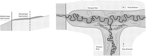
While catchment lithology thus exerts a broad control on the location of the Tshwane–Pienaars floodplain wetlands, net aggradation within the wetlands is promoted by downstream declines in discharge, stream power and sediment transport capacity. As shown by studies of other South African and Australian wetlands in drylands, downstream decreases in discharge and associated sedimentation arise from a complex interplay between climatic and intrinsic controls (e.g. O'Brien and Burne, 1994; Tooth et al., 2002b, 2014; Ralph and Hesse, 2010; Pietsch and Nanson, 2011). In the confined headwater reaches of the Tshwane and Pienaars Rivers, relatively large discharges are competent to transport supplied sediment and the channels have stable beds or undergo net incision. Once the channels begins to traverse wider floodplains farther downstream, however, discharge starts to decrease (Figures 9A and 9C) owing to transmission losses resulting from seepage through bed and banks, increased evapotranspiration as overbank floodwaters disperse, and a general lack of significant tributary inputs. Downstream discharge decreases are associated with decreases in stream power (Figures 9B and 9D) and thus sediment transport capacity. Finer sediment is deposited on levees and alluvial ridges (Figure 11A), while coarser bedload sediment remains largely within the channel beds, contributing further to downstream channel size decreases.
In the unconfined lower reaches, lateral meander migration leads to some reworking of alluvium, but net vertical aggradation is clearly occurring. Topographic surveys (Figure 10A) and satellite imagery (Figure 10B) reveal the prominent alluvial ridges and levees of the modern channels and palaeochannels in the Tshwane–Pienaars wetlands, and augering indicates that all channels are fully alluvial and not grounded on bedrock. Alluvial sediment is at least 7 m thick, and combined with the floodplain width (1–2 km), indicates substantial sediment storage in these floodplain wetlands. Development of prominent alluvial ridges and/or levees primes some older, more elevated channel reaches for avulsion and abandonment, with flows commonly being diverted into new channels on topographically-lower parts of the floodplain. As Larkin et al. (in review) demonstrate, these new channels typically form when knickpoints develop at breaches in the channel banks and retreat headward as overbank floodwaters drain from the backswamps (Figure 11D). In other South African floodplain wetlands, this process of incisional avulsion (Tooth et al., 2007, 2009) has been shown to be another key process by which meandering channels rework floodplain alluvium, and the numerous palaeochannels in the Tshwane–Pienaars floodplain wetlands suggest that here too avulsion is a key component of channel–floodplain dynamics. Finally, as noted earlier, the development of prominent alluvial ridges and levees on trunk channels can also prolong inundation and promote sedimentation along tributaries such as the Tshwane.
Unchannelled floodplains (floodouts)
Other floodplain wetlands in the Tshwane and Pienaars catchments are characterized by distinctly different channel and floodplain features. The Stinkwaterspruit and the Soutpanspruit, for instance, are both characterized by discontinuous channels and floodouts. Stinkwaterspruit is an ephemeral tributary of the Tshwane River (Figure 1). Approximately 8 km upstream from the confluence, the channel breaks down into numerous straight distributary channels, many of which terminate at a floodout (Figure 13A). Very little sediment is transported beyond the floodout, and water likely reaches the Tshwane only during the largest floods. The Itsoseng wetlands occur where Soutpanspruit breaks down into a series of straight distributary channels, forming a floodout that is characterized by an unchannelled reedswamp (Figure 13B). Much sediment is trapped within the floodout, and deposition has formed a pronounced fan-shaped lobe with a slightly steepened downstream edge (Figures 13B and 13C). Similar to the situation in some other South African floodplain wetlands (Grenfell et al., 2014; Tooth et al., 2014), discontinuous ephemeral rivers (Schumann, 1989; Bull, 1997; Merritt and Wohl, 2003), and floodouts in eastern Australia (Gore et al., 2000), shallow headcutting channels have formed on the slightly steepened downstream edge, and serve to convey the limited flows seeping across the floodouts.
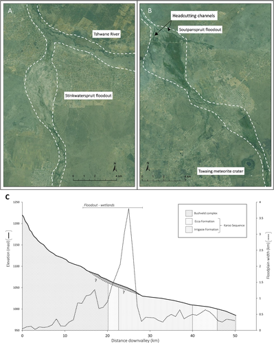
By comparison with the larger Tshwane and Pienaars Rivers, where there is a strong lithological influence on floodplain width and wetland location (Figure 4), clear or systematic lithological influences on these discontinuous systems are less readily apparent. On the Stinkwaterspruit, channel breakdown and floodout formation occur atop the sedimentary lithologies of the Karoo Supergroup (Figure 2). On the Soutpanspruit, channel breakdown starts on the Bushveld Complex granite, and the Itsoseng wetlands have developed atop the transition to the Karoo Supergroup lithologies where they reach maximum width (Figures 2 and 13C). Additional morphological, hydraulic and sedimentological analyses of these wetlands will be required to determine whether channel breakdown and floodout formation is related to decreases in slope, and associated reductions in stream power and sediment transport capacity, that may coincide with the transition from Bushveld Complex granite to Karoo Supergroup lithologies (e.g. Figure 13C).
Evidence from other small, discontinuous channels in the catchment, however, suggests that lithological influences may be muted relative to other possible influences on channel breakdown. For instance, the Plat River, a south-flowing tributary of the Pienaars River near the town of Kgomo Kgomo (Figure 1), does not maintain a channel to the confluence but instead is characterized by a discontinuous, sinuous channel which terminates in backswamps (Figure 10A). Downslope, a sinuous palaeochannel appears to have formerly maintained a course to the Pienaars (Figure 10A) but is now slowly being infilled. A similar situation occurs in some other South African and Australian floodplain wetlands where wetlands or temporary lakes develop along small tributaries that are blocked by alluvial ridges and/or levees developed along trunk channels (O'Brien and Burne, 1994; Finlayson and Kenyon, 2007; Grenfell et al., 2009). In the case of the Plat River, channel breakdown may have been driven by base level rise associated with the aggradation of the Pienaars floodplain wetland.
Discussion
In the Tshwane and Pienaars catchments, it is intriguing that such a variety of floodplain wetlands are found in close proximity in an area with similar extrinsic (lithological, climatic) controls. Larger rivers such as the Tshwane and Pienaars undergo downstream declines in discharge and stream power but maintain continuous, through-going channels, while some smaller rivers are more discontinuous, with channel breakdown leading to floodout formation. Across the South African drylands more generally, similar contrasts can be found. In the subhumid parts of eastern and north-eastern South Africa, most floodplain wetlands tend to be characterized by continuous, through-going channels (e.g. Tooth et al., 2002a; Grenfell et al., 2009), while in the semi-arid to arid parts of northern and south-western South Africa, many channels are more discontinuous and associated with floodouts (Tooth et al., 2002b; Grenfell et al., 2014). Although there are some notable exceptions (e.g. Tooth et al., 2014; Joubert and Ellery, 2013), this broad pattern suggests that at the subcontinental scale, climate may exert a strong, possibly dominant, influence on floodplain wetland characteristics, albeit in combination with local lithological and intrinsic factors.
A conceptual model of climatic influences on floodplain wetland characteristics
- The Klip River wetlands have formed upvalley of a resistant dolerite sill that promotes lateral channel migration and valley widening in the reaches upstream (Tooth et al. 2002a; Marren et al., 2006). In this subhumid setting, discharge increases slightly downstream and the Klip River maintains a continuous, through-going channel. Long-term vertical aggradation rates are effectively zero (Rodnight et al., 2005; Marren et al., 2006, Tooth et al., 2007, 2009), suggesting an approximate balance between sediment input and output.
- The Tshwane–Pienaars wetlands (this study) are located in a more semi-arid climate, which leads to downstream decreases in discharge and channel size. Net vertical aggradation in the wetlands results from an imbalance between sediment input and output. Despite downstream decreases in channel size, both the Tshwane and Pienaars Rivers nonetheless maintain continuous, through-going channels, although evidence for channel breakdown and floodout formation on several smaller tributaries suggests that both rivers may be operating close to a threshold between through-going and discontinuous. In the larger Tshwane and Pienaars Rivers, discharges are sufficient to maintain continuous channels, whereas in smaller rivers with lower and/or more irregular discharges, this appears to not be the case.
- The Nyl River wetlands are located in a marginally more arid setting, and this river and many of its tributaries are also subject to downstream decreases in discharge and channel size (Tooth et al., 2002b; McCarthy et al., 2011). Many channels get progressively smaller downstream before terminating at floodouts. Along the unchannelled part of the main Nyl valley, net aggradation is clearly occurring, as evidenced by alluvial deposits that are up to 35 m thick (Tooth et al., 2002b; McCarthy et al., 2011). Local aridity and vegetation growth leads to high evapotranspiration, as evidenced by subsurface chemical sedimentation and the formation of salinized islands on the floodouts (Tooth et al., 2002b).

| Wetland | Local climatic setting (MAP, MAE and aridity index) | Key factors influencing development of floodplain wetlands | Geomorphological features and processes associated with the wetlands | Key references and other example wetlands | |
|---|---|---|---|---|---|
| Klip River, Free State, South Africa | Subhumid (~800 mm, ~1890 mm; aridity index – 0.42) | Wetlands located upvalley of erosion-resistant dolerite sill, which resists downcutting and promotes lateral migration and floodplain wetland formation. | Mixed bedrock-alluvial, through-going channel. Oxbows, backswamps, palaeochannels, meandering channels, scroll bars, muted levees and alluvial ridges | Tooth et al., 2002b, 2004, 2007; Marren et al., 2006
Nsonge River, eastern South Africa – Grenfell et al., 2014 |
|
| Tshwane–Pienaars Rivers, North West Province, South Africa | Semi-arid (~585 mm, ~1750 mm; aridity index – 0.33) | Pienaars wetlands formed upstream of resistant granite bedrock. In the reaches upstream, downstream declines in discharge and stream power promote channel size decreases, lateral instability, sediment accumulation and wetland formation. | Fully alluvial, narrowing but through-going channel. Oxbows, backswamps, palaeochannels, prominent levees and alluvial ridges, floodouts on some tributaries | This study | |
| Nyl River, Northern Province, South Africa | Semi-arid (~623 mm, ~2400 mm; aridity index – 0.26) | Downstream declines in channel size and sediment transport efficiency predispose the Nyl to channel breakdown. Farther downvalley, prograding tributary fan sediments promote ponding and floodout formation. | Fully alluvial channel that declines in size downstream. Floodout formation, backswamps, islands formed by chemical sedimentation resulting from high evapotranspiration | Tooth et al., 2002a; McCarthy et al., 2011
Seekoei River, central South Africa – Grenfell et al., 2014 |
Climatic influences relative to other extrinsic and intrinsic factors
These observations complement and extend previous attempts to isolate the influence of climate on wetland forms and processes in the South African drylands. Using an east–west transect, Grenfell et al. (2014) compared two different wetlands that have formed on Karoo Supergroup sandstones and mudstones upstream of intrusive dolerite dykes; the Nsonge River in the subhumid Drakensberg foothills, eastern South Africa (aridity index 0.59) and the Seekoei River in semi-arid, central South Africa (aridity index 0.18). The Nsonge River is characterized by a through-going, laterally migrating channel with very little vertical aggradation (Grenfell et al., 2014). The Seekoei River is characterized by a discontinuous channel separated by floodouts. Avulsion is driven by aggradation on the floodout, and channels reform on the steepened downstream end of the associated sediment lobe. Similar to our findings and interpretations, Grenfell et al. (2014) argue that while the flows along the Nsonge River are able to maintain a through-going, meandering channel that slowly recycles floodplain sediment, the more seasonal, sporadic flows along the Seekoei are not sufficient to maintain a continuous channel and sediment is sequestered in floodouts for longer periods of time.
This comparison of floodplain wetlands across the South African drylands supports an hypothesis that increasing aridity, with its influence on discharge and sediment transport capacity, tends to be associated with a reduction in the ability of rivers to maintain through-going channels and an increase in the propensity for channel breakdown and floodout formation (Figure 14). Other extrinsic controls (especially local and regional lithological variations) and intrinsic controls can exert influences on floodplain wetland characteristics but in many instances climate may be the dominant control. These insights are significant in view of future climate projections that suggest that total rainfall in southern Africa will either decline or remain constant, but in either instance is likely to become more spatially and temporally variable (IPCC, 2013). While river responses to such climatic changes are hard to predict, the range of fluvial processes and forms observed across the climatic gradient outlined above may provide indications of the future developmental pathways of some floodplain wetlands. Both across South Africa and other drylands that may be subject to similar climate changes, it is possible that currently through-going rivers may become discontinuous under increasingly arid climates and/or more variable rainfall, with significant implications for changes to water supplies, sediment storage, habitat provision, and many other ecosystem services. Against this backdrop, further study of rivers such as the Tshwane and Pienaars, both of which appear to be operating close to a threshold between continuous and discontinuous river styles, will be particularly important. These rivers might be seen to represent ‘sentinel wetlands’ for examining channel and floodplain responses to future climatic changes, and may also provide test cases for the development of adaptive management strategies or mitigation measures to limit undesirable changes to wetland ecosystem service delivery.
Conclusion
The findings presented in this paper demonstrate the complex interplay between extrinsic and intrinsic controls on the characteristics of floodplain wetlands in drylands. By combining a detailed examination of the Tshwane–Pienaars floodplain wetlands with previous findings from several other South African wetlands, we have developed a new conceptual model that explains variations in floodplain wetland characteristics across a subhumid to semi-arid climatic gradient. Wetter, subhumid systems are characterized by an approximate balance between sediment supply and sediment transport, which helps to maintain through-going channels, while more arid systems are characterized by decreasing sediment transport capacity, leading to aggradation and channel breakdown. Ergodic reasoning can be used to suggest that as aridity increases in drylands due to anthropogenic climate change, some currently through-going rivers may become more discontinuous, with significant implications for changes to downstream water supply, sediment storage, habitat provision and many other ecosystem services. Further analysis of the interplay between extrinsic and intrinsic factors may provide a firmer basis for anticipating and managing potential wetland changes, particularly under projected future drier, more variable climates, both in South Africa and other drylands. The challenge for geomorphologists will then be to translate such research findings into knowledge that can be assimilated by wetland managers and implemented in on-the-ground activities.
Acknowledgements
This research was funded by a British Society for Geomorphology Postgraduate Research Grant (Larkin), a National Geographic Young Explorers Grant (No. 9670-15: Larkin, Ralph, Tooth and McCarthy), and Macquarie University postgraduate research funds (Larkin). Additional fieldwork costs were supported by discretionary research funds (Ralph). Michael Grenfell is thanked for providing aerial photographs, topographic maps and a digital elevation model (DEM) of the Tshwane and Pienaars Rivers.


