Influence of subaqueous processes on the construction and accumulation of an aeolian sand sheet
ABSTRACT
In aeolian sand sheets the interaction between aeolian and subaqueous processes is considered one of the principal factors that controls this depositional environment. To examine the role played by the subaqueous processes on the construction and accumulation of sand sheets, surface deposits and subsurface sedimentary sections of a currently active aeolian sand sheet, located in the Upper Tulum Valley (Argentina), have been examined. On the sand sheet surface, airflows enable the construction of nabkhas, wind-rippled mantles (flattened accumulations of sand forming wind ripples), megaripples, and small transverse dunes. Subaqueous deposits consist of sandy current ripples covered by muddy laminae. The latter are generated by annual widespread but low-energy floods that emanate from the nearby mountains in the aftermath of episodes of heavy precipitations. Deposits of subaqueous origin constitute 5% of the accumulated sand sheet thickness.
The construction of the sand sheet is controlled by meteorological seasonal changes: the source area, the San Juan river alluvial fan, receives sediment by thaw-waters in spring–summer; in fall–winter, when the water table lowers in the alluvial fan, the sediment is available for aeolian transport and construction of the sand sheet area. The flood events play an important role in enabling sand sheet accumulation: the muddy laminae serve to protect the underlying deposits from aeolian winnowing. Incipient cement of gypsum on the sand and vegetation cover acts as an additional stabilizing agent that promotes accumulation. Episodic and alternating events of erosion and sedimentation are considered the main reason for the absence of soils and palaeosols. Results from this study have enabled the development of a generic model with which to account for: (i) the influence of contemporaneous subaqueous processes on the construction and accumulation in recent and ancient sand sheets; and (ii) the absence of developed soils in this unstable topographic surface. Copyright © 2013 John Wiley & Sons, Ltd.
Introduction
This paper examines the sedimentary processes and depositional architecture of a currently active, intermontane aeolian sand sheet, located in the Upper Tulum Valley (San Juan Province, Argentina), which is affected by seasonal fluvial floods that spread over the entire surface of the sand sheet in the aftermath of episodes of heavy precipitation.
Aeolian sand sheets are extensive, flat to gently undulating sandy surfaces covered predominantly with wind ripples and small dunes that lack an active slipface, such as nabkhas or zibars (Fryberger et al., 1979; Kocurek and Nielson, 1986; Laity, 2008; Pye and Tsoar, 2009). Modern aeolian sand sheets constitute a significant proportion of desert systems worldwide and, although most well-known examples are located at the margins of dune fields (Fryberger et al., 1979), a number of examples have been also documented from coastal, alluvial fan, ephemeral river, and periglacial settings (Kocurek and Nielson, 1986; Langford, 1989; Mountney and Russell, 2004, 2006). Within areas of aeolian sand sheet, many factors operate individually or in combination to retard aeolian dune development, including low rate of sand supply, high water table, surface cementation or binding, periodic flooding, the presence of a significant population of coarse-grained sediment, and vegetation (Kocurek and Nielson, 1986; Breed et al., 1987; Chakraborty and Chakraborty, 2001).
In a Late Cretaceous aeolian sand sheet, Basilici et al. (2009), Basilici and Dal' Bó (2010), and Dal' Bó et al. (2010) demonstrated that the sand availability during the phase of construction of the sand sheet was limited by the presence of Bk or Bkm soil horizons (calcrete), formed during a previous phase of topographic stability and pedogenesis. These cemented horizons protected the underlying deposits from the deflationary processes of the wind, thereby limiting the availability of sediment for aeolian transport. In the Upper Tulum Valley current active aeolian sand sheet and their recent sedimentary successions are notable for the absence of hardened soil or palaeosol horizons; thus, other factors should influence the low availability of sand in this sand sheet for aeolian transport.
Interactions between aeolian and subaqueous processes are an important sedimentological component of desert environments (Glennie, 1970; Mountney, 2006), and have been described in modern (Ahlbrandt and Fryberger, 1981; Kocurek, 1981; Langford, 1989; Bullard and Livingstone, 2002; Bullard and McTainsh, 2003; Al Farraj and Harvey, 2004; Saqqa and Atallah, 2004; Mountney and Russell, 2009), as well as ancient depositional settings (Langford and Chan, 1988, 1989; Veiga et al., 2002; Mountney and Jagger, 2004). Despite this, relatively few studies have specifically examined aeolian/subaqueous processes in aeolian sand sheet (Trewin, 1993; Chakraborty and Chakraborty, 2001; Maxwell and Haynes, 2001; Tripaldi and Limarino, 2008).
In general, it is believed that aeolian processes are dominant in arid climate phases (aeolian-dominated system, sensu Bullard and Livingstone, 2002) and subaqueous activity is restricted to more humid climate phases (fluvial-dominated system, sensu Bullard and Livingstone, 2002). Few studies have attempted to investigate the interactions of aeolian and subaqueous-derived sediments as a consequence of short-term or contemporaneous autogenic processes, which sometimes result in vertical interbedding of aeolian and subaqueous facies (Lancaster, 1997; Krapf et al., 2005; Tripaldi and Limarino, 2008; Mountney and Russell, 2009).
The aim of this paper is to understand how repetitive, high-frequency flood events in combination with other constraining factors can act to dictate the architecture, construction and accumulation of the aeolian sand sheet. Specific objectives of this study are as follows: (i) to describe the morpho-depositional superficial structures and the lithofacies in the exposed sedimentary succession and to interpret them in terms of formative sedimentary processes; (ii) to characterize a geometrical model of the deposits in term of architectural elements; (iii) to apply the principles of construction, accumulation, and preservation of an aeolian system (Kocurek, 1999, 2003; Kocurek and Lancaster, 1999) to this present sand sheet.
This work has two significant aspects that may be applied to the study of recent and ancient sandy sheet systems: (i) it considers the influence of contemporaneous subaqueous processes to generate the architecture of an aeolian sandy sheet; (ii) it verifies the conditions required for the development of pedogenesis in these environments.
Geological and Climate Setting
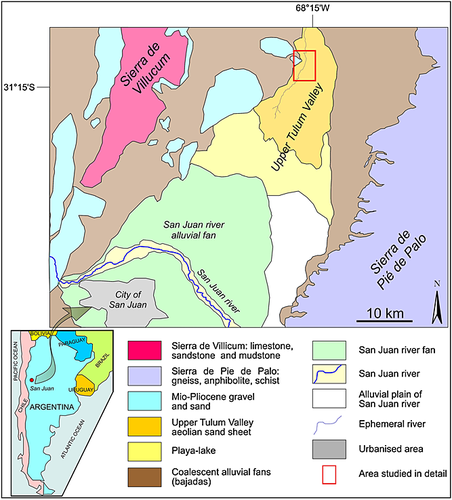
The aeolian sand sheet considered in this study covers an area of ~105 km2 in the Upper Tulum valley, which is located about 45 km north of the city of San Juan (Argentina) (Figure 1). The Upper Tulum Valley is an intermontane depression that trends NNE–SSW; the Sierra de Pie de Palo is its boundary to the east and the Sierra de Villicum is to the west. The sand sheet is present from an altitude of 620 m asl to 585 m asl, from the NNE towards the SSW portion, having a mean slope of 0.13°. On its western side the sand sheet is crossed by a dry river channel, with maximum width of 130 m, which in a downstream direction (SSW), progressively decreases, disappearing at the transition to a playa-lake (Figure 1). At the western and eastern sides, small, coalescent alluvial fans form a bajada that separates the sand sheet from the Palaeozoic and older bedrock (Figure 1). At its southern margin the aeolian sand sheet gradually passes into a playa-lake (cf. Briere, 2000), characterized by precipitation and growth of superficial gypsum crusts. Southwards the playa-lake is delimited by the widespread alluvial fan of the San Juan river, developed at the point where it emerges from the Precordillera gorges, and by the alluvial plain of the same river (Figure 1) (Lloret and Suvires, 2006; Suvires and Luna, 2008). The Sierra de Pie de Palo is part of the geo-structural province of the Sierra Pampeanas, and it is formed by Proterozoic high-grade metamorphic rocks (amphibolite, gneiss, biotitic and feldspathic schist). The Sierra de Villicum is part of the Argentine Precordillera geo-structural province, it is composed of Palaeozoic carbonate rocks and, secondarily, of sandstone and mudstone. On the western margin of the sand sheet, Mio-Pliocene gravel and sand, crop out in small hills (Servicio Geológico Minero Argentino, 2000) (Figure 1). An active northwest fault plane exists beneath the Tulum Valley at the depth of 5–35 km. Meigs et al. (2006) proposed a structural model where thrust faults and/or monocline folds are the near-surface expression of this northwest-dipping fault plane (their Figure 11). These active superficial structural elements delimit the Tulum Valley basin, which has accumulated an almost 3000 m thick succession of deposits from the Late Miocene to the present (Servicio Geológico Minero Argentino, 2000; Lloret and Suvires, 2006; Meigs et al., 2006).
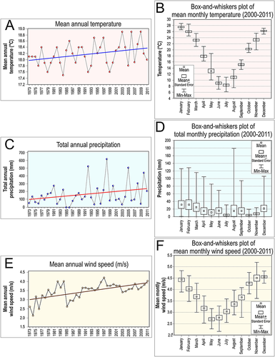
The area of the Upper Tulum Valley sand sheet is a rain shadow desert, controlled by the Andean Cordillera, which acts as a topographic barrier to the humidity coming from the Pacific Ocean. Since 1973, weather data (data available at http://www.tutiempo.net/clima/San_Juan_Aerodrome/873110.htm) have been recorded from the Meteorological Station of the Airport of San Juan, which is located approximately 40 km to the SSW of the study area. Based on the climatic data for the period 1973–2011, the mean annual temperature is 18.2 °C, with mean annual maximum and minimum temperatures of 26.6 °C and 10.3 °C, respectively; the mean annual temperature displays a weak increase (Figure 2(A)). Data recording monthly temperature for the period 2000 to 2011 exhibit maximum temperatures in December–March and minimum temperatures in May–August (Figure 2(B)). The annual precipitation from 1973 to 2011 varies from 0.25 to 618.7 mm, the mean value is 194.7 mm (Figure 2(C)), with a gradual increase. The monthly analysis of the available climatic data from 2000 to 2011 show that more than 70% of the total annual precipitation fall in the period from December to April (Figure 2(D)), although with some anomalies for the period from 2007 to 2011. Climate data also reveal that up to 64% of the annual precipitation can fall in only one day. According to the Köppen–Geiger climate classification this area can be classified as Group BWh, where B means dry (arid or semiarid) climate, W means desert climate and h means low latitude climate. The hydric balance is negative, because evaporation greatly exceeds precipitation rates; the volume of annual precipitations only accounts for 5% of the total amount of evaporated water (Suvires, 2004). From 1973 to 2011, the mean annual wind speed registered a steady increase from 3 to 4 m s-1 (Figure 2(E)). From 2000 to 2011 the mean monthly wind speed was >4 m s-1 in October–February and <3 m s in May and June (Figure 2(F)). Wind is not a limiting factor for sand movement because the threshold wind velocity required to induce sand transport (approximately >3 m s-1 at 2 m from the surface) (Livingstone and Warren, 1996), is attained episodically, principally during summer months (Figure 2(F)). No data regarding wind direction were available from the meteorological station. During the field work the main wind direction was towards N20–30. This direction is in agreement with data recorded in the present study from sedimentary structures that indicate a net direction of sediment transport towards N–NE, as described below.
Although the vegetation cover is present over the entire sand sheet surface with a density of 3–7% of the topographic surface, it tends to be preferential developed along the axis of the dry river channel, where its density can reach 30%. Dominant species comprise seasonal Graminae, perennial shrubs (Bulnesia retama, Geoffroea decorticans, Larrea divaricata) or small trees (Prosopis flexuosa). The vegetation cover decreases progressively towards the SSW, towards the playa-lake.
Data Set and Methods
General morphological features were mapped at regional scale using Landsat ETM + and Google Earth images that were later verified on the ground. Over the course of two field seasons (October 2008 and January 2011), the superficial morpho-depositional bedforms and the subsuperficial sedimentary succession were described in detail in an area of c. 10 km2 of the sand sheet (Figure 1). Other less-detailed descriptions were made where the sand sheet undergoes transition to the playa-lake. On the ground, the morphological characteristics of the main bedforms (dunes, wind ripples, wind megaripples, current ripples, flooding deposits) have been assessed by measuring the dimensions (long and short axis length, height), crestline orientation, textural features, and relationship with the other morphological elements. Five nabkha dunes were dissected along their long and short axes to describe the internal organization of the beds (geometry, texture, bounding surfaces, lithofacies). Subsuperficial analyses were undertaken through examination of natural outcrops on the erosive banks of the dry river channel, which expose a sedimentary succession below the present topographic surface up to 3.1 m thick. Three vertical (2.0–3.1 m thick) and two horizontal (up to 350 m wide) stratigraphic sections were measured and analysed to define the textural features, geometry, bounding surfaces, and lithofacies of the beds. Forty-seven sand samples were collected and analysed for texture and petrography. One of these was collected to determine optically stimulated luminescence (OSL) dating. OSL analysis was carried out at the Laboratory of Glasses and Dating of the Faculdade de Tecnologia de São Paulo, Brazil, using an OSL Automated System, model 1100-series of Daybreak Nuclear Instruments.
Surface Sedimentology
Non-depositional and deflationary areas
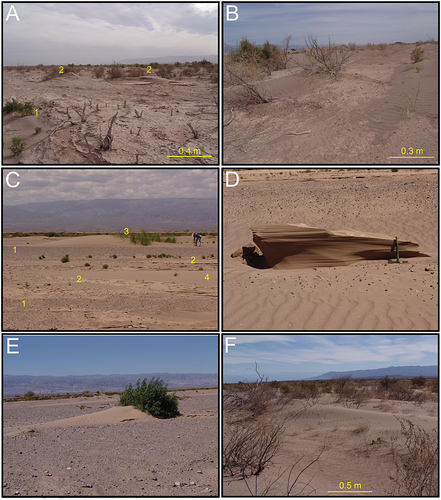
In October 2008, most of the sand sheet was overlain by laminae of light yellow orange mud with desiccation cracks (Figure 3(A)). Most of the aeolian features were partially disrupted by the flooding event (which probably occurred on 5 September 2008) and overlain by mud. Evidence for post-flood renewal of active aeolian deposition was present mainly around the dry river channel belt for a width of around 1 km (Figure 3(B)), whereas the rest of the area constituted a bypassing surface at the time of study.
Deflationary areas are not common on the Upper Tulum Valley sand sheet. Gravel lags, composed of pebbles and armoured balls, are observed within the dry channel, probably generated by winnowing of previously deposited fluvial sediments (Figure 3(C)). Gravel lags also characterize the surface of small outcrops of Mio-Pliocene gravelly sands, where ventifact pebbles are common. Aeolian erosion may generate small yardang-like structures within the dry channel (Figure 3(D)) (cf. Laity, 1994).
Aeolian processes and deposits
On this sand sheet the main aeolian bedforms are nabkha dunes, wind ripples, wind megaripples, and small transverse dunes.
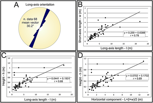
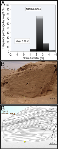
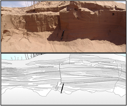
Nabkha (or nebkha or coppice) dunes (Langford, 2000) are the most common bedforms identified in the field (Figure 3(E)). Nabkha dunes are active and anchored dunes, that comprise deposition of sand that develop directly downwind from an obstacle, which typically takes the form of xerophytic and halophytic species of shrubs (Larrea divaricata, Geoffroea decorticans, Bulnesia retama, Atripex lampa), small trees (Prosopis flexuosa), and/or small herbs. The downwind portion and the flanks of the dunes are entirely covered by wind ripples (Figure 3(E) and (F)). Most developed bedforms occur along the margins of the dry-channel bed (Figure 3(F)), where several nabkhas overlap forming amalgamated dunes by lateral linking and merging. Data recording the orientation of long axis, height, long and short axis length of 68 nabkha dunes are reported in Table 1 and Figure 4. The relationships between their short- and long-axis length (Figure 4(B)), height and long-axis length (Figure 4(C)), and height and horizontal component (Figure 4(D)) display a positive correlation, which is described by a linear function fitted to the data. The internal structure of the nabkhas is dominated by planar and low-angle laminae, characterized by <1–5 mm thick alternations of well-sorted, subangular to subrounded, fine-, or medium fine-, and very fine-grained sand (Figure 5(A)). Inverse grading of the laminae, emphasized by very coarse-grained sand mud clasts, is relatively common. In section along the short axis of the dune, the laminae dip 6–12° in the same direction as the dune flank, and they form sets up to 0.12 m thick and 0.35 m wide (Figure 5(B)). In longitudinal section, the laminae and the bounding surfaces are inclined at gentle angles (0.5–3º), with a lateral continuity of more than 1 m (Figure 6). Different orders of erosional bounding surfaces, horizontal and up to 12° dip, divide the lamina set (Figures 5(B) and 6). Bioturbation is mainly associated with the penetration of sub-vertical roots.
| Long-axis direction | Long-axis length (m) | Short-axis length (m) | Height (m) | |
|---|---|---|---|---|
| Max | 45º | 21.7 | 5 | 1.1 |
| Min | - | 0.5 | 0.2 | 0.07 |
| Mean | - | 4.43 | 1.78 | 0.38 |
The laminae that constitute the internal structure of the nabkhas are the expression of superficial wind ripples, they correspond to the deposition of subcritically climbing translatent strata (Hunter, 1977). These laminae display greater dip on the lateral flanks of the dune, where wind ripples climb up to 12°, whereas the wind ripple climbing angle is 0.5–3º dip on the central part of the dune. Bounding surfaces that divide the lamina sets are caused by different phases of destruction and reconstruction of the dune as a result of different wind velocity and/or sand concentration on the airflow. The presence of vegetation is essential for the initiation, growth, and stabilization of nabkhas (Tengberg and Chen, 1998), because it acts as an obstacle to the air flow, causing deceleration and deposition of sand (Thomas and Tsoar, 1990).
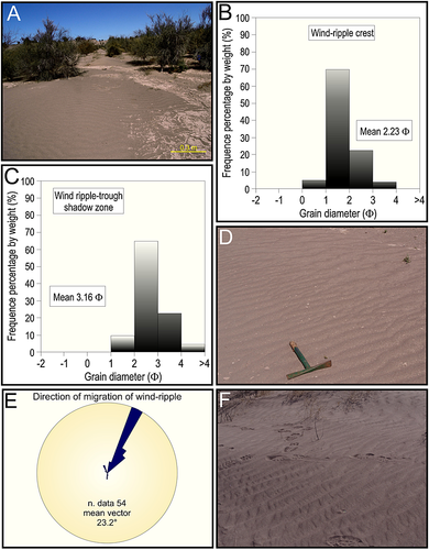
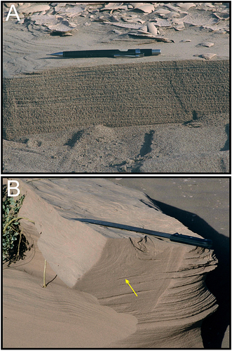
Wind ripples also occur on the interdune areas or in more open areas where they form flattened sand sheet of some tens of square metres, which is here referred to as wind-rippled mantle (Figure 7(A)). Ripple crest are characterized by moderately sorted, medium fine-grained sand (Figure 7(B)), while the ripple-trough shadow zone is covered by fine or very fine-grained sand (Figure 7(C)). A qualitative petrographic analysis reveals an assemblage composed, in order of abundance, of lithic fragments (mainly volcanic, secondarily carbonate clasts), quartz, and K-feldspars. Mud clasts, each a few millimetres to 30 mm across, cover and interbed with the sand (Figure 7(D)). Morphological parameters are in Table 2. In plan view, the ripple crests are straight or weakly undulated and bifurcated; the flow direction indicates movement toward N23 (Figure 7(E)), with a weaker dispersion, which reflects secondary wind directions, that locally produce interference ripple structures (Figure 7(F)). The internal structure of the wind-rippled mantles is constituted of fine-grained sandy laminae, 2–3 mm thick, alternated with very fine-grained sandy laminae, <1 mm thick, which correspond to subcritically climbing translatent strata (Hunter, 1977) (Figure 8(A)). The laminae are low-angle, parallel, and continuous for several metres; low-angle, erosive bounding surfaces, separate sets 0.08–0.45 m thick. Locally, the laminae are accentuated by a thin accumulation of very fine-grained sand clasts of magnetite (Figure 8(A)). Ductile soft-sediment deformations can be observed, probably produced by sand liquefaction (Figure 8(B)).
| Wind ripples | Wind megaripples | Current ripples | |
|---|---|---|---|
| Height (mm) | 2–5 | 10–50 | 10–20 |
| Spacing (m) | 0.05–0.225 | 0.6–1.2 | 0.09–0.18 |
| Mean of ripple index | 44.9 | 34 | 10.3 |
| Mean of ripple symmetry | 3.6 | 2.5 | 3.1 |
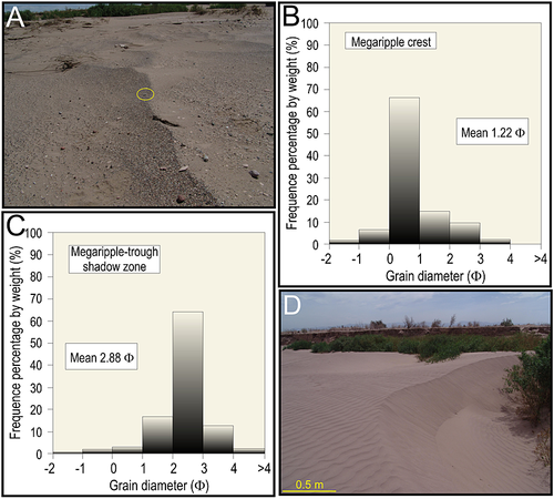
Megaripples (or granule ripples) (Sharp, 1963; Fryberger et al., 1992; Mountney and Russell, 2004) were observed only in a small area of 300 m2 on the bed of the dry river channel (Figure 9(A)). These asymmetric bedforms are composed of poorly sorted, fine-grained sand to granule; coarse-grained sand to granule clasts are concentrated on the ripple crest and on the stoss side near the crest (Figure 9(B)), whereas fine and medium-grained sand covers the megaripples-trough shadow zone (Figure 9(C)). Morphological parameters are in Table 2. The crestline is sinuous and the bifurcation are uncommon; in general, stoss sides are 10° dip and lee side up to 22° dip. These bedforms indicate a transport direction towards N30–45.
Dunes with well-developed, active slipfaces are uncommon in the study area. In October 2008, on the bed of the dry river channel, small crescent-shaped transverse dunes covered an area not greater than 400 m2 (Figure 9(D)), but they were no longer present in January 2011. The dunes were composed of well-sorted fine sand; their spacing was 10–12 m. These bedforms had slipfaces up to 1 m high, dipping 33°, and characterized by grain flow deposits; their stoss sides were covered by wind ripples and devoid of vegetation. Their presence within the bed of the dry channel may be due to the relatively greater availability of sand for aeolian construction and the absence of vegetation (Fryberger and Dean, 1979; Pye and Tsoar, 2009).
Subaqueous processes and deposits
On the Upper Tulum Valley sand sheet, subaqueous processes generate sandy current ripples overlain by laminae of light yellow orange mud.
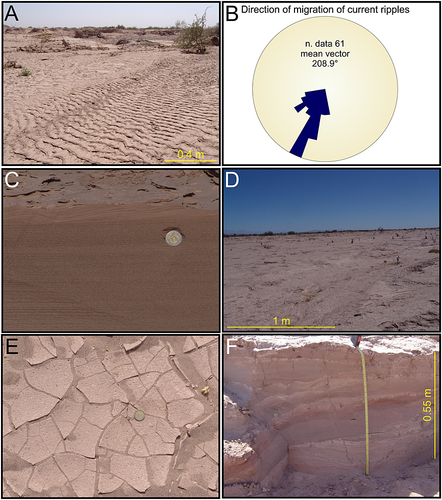
On the surface, the current ripples are asymmetric, they have straight crest lines, and current direction on average towards N209 (Figure 10(A) and (B)). Morphological parameters are shown in Table 2. These forms are composed of well-sorted to moderately well-sorted, very fine-grained sand. In section, the current ripples are organized in one to three sets of cross-laminations, 10–50 mm thick, with lateral continuity of tens of metres (Figure 10(C)). Current ripples abruptly overlie wind ripple strata, without apparent erosive surface; they are always overlain by a lamina of muddy deposits (Figure 10(C)). Muddy deposits (95% of the grain size distribution >4 phi) cover almost the entire sand sheet surface with a thickness varying between 1–10 mm (Figure 10(D)). On the surface, they are characterized by polygonal cracks, 20–100 mm in diameter, and display rain drop impressions, animal footprints, and bioturbation traces (Figure 10(E)). When cracked and broken into fragments, these muddy deposits also constitute an important source of low-density intraclasts. In small tranches, 0.6 m deep, one observes that muddy layers are commonly interbedded with wind ripple strata (Figure 10(F)).
The Upper Tulum Valley aeolian sand sheet is crossed along its western portion by a dry river channel, whose width varies between 25–130 m in the study area and decreases downwards to disappear towards the south. The channel is separated from the sand sheet by incised banks up to 3.5 m deep. During the field work subaqueous deposits, with the exception of those already described, were not observed on the channel bed, which was principally covered by aeolian deposits. The incised channel and gravel lags of armoured ball and pebbles, constituted of clasts coming from the nearby mountain-front catchment area, are the only evidence of fluvial processes. Satellite imagery from 2003 of this area from Google Earth (http://www.google.com/earth/index.html, last access in January 2013) has displayed a wide river channel bed without vegetation, locally characterized by elongated bedforms, similar to longitudinal fluvial bars. The same area in the following years, as observed directly or from satellite imagery, was covered by aeolian bedforms and vegetation. Therefore, one may conclude that the fluvial system has recurring active events with a minimal period of 10 years, but that the bedforms that are deposited during the stream flow have virtually no potential for long-term preservation as they are quickly reworked by aeolian processes.
The presence of current ripples and muddy deposits in an aeolian setting suggests periodical water-driven processes in the sand sheet area, as described by other authors (Ahlbrandt and Fryberger, 1981; Kocurek, 1981; Kocurek and Nielson, 1986; Lancaster and Teller, 1988; Langford, 1989; Langford and Chan, 1989). Small ripples with straight crest lines, covered by muddy deposits, indicate that the water flows were characterized by low velocities. The subaqueous deposits cannot have been originated by floods coming from the incised dry river channel, because these deposits are spread over the entire study area at topographic elevations up to 30 m above the river bed. Moreover, the absence in the channel bed of subaqueous dunes, bars, or debris flow deposits suggests that during the episodic floods the incised channel did not transport more water than the surrounding sand sheet area. In a study of the Jurassic Entrada Sandstone Formation (Utah), Kocurek (1981) described an array of subaqueous sedimentary features of interdune deposits in an aeolian system characterized by the absence of channels. This author interpreted the Jurassic water-laid deposits as products of ephemeral shallow floods associated to heavy precipitations. A flash flood can be generated in a desert environment as a consequence of a rainfall event, especially when the rain is of high intensity (Lancaster and Teller, 1988). According to the historical meteorological data available for the Upper Tulum valley, at least once a year a quantity of rain, which may correspond to up to 64% of the entire annual precipitation, falls. These relatively high-magnitude rainfall events result in flow into small (up to 0.5 m deep), channelized ephemeral creeks coming from the nearby mountains that invade the sand sheet areas generating a widespread flood. Thus, the subaqueous deposits of the Upper Tulum Valley sand sheet were interpreted as having been originated by heavy precipitations.
Subsurface Sedimentology
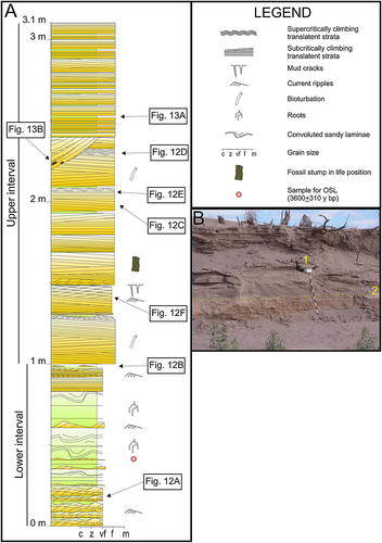
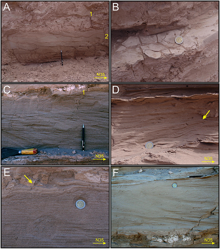
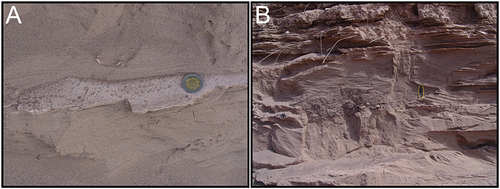
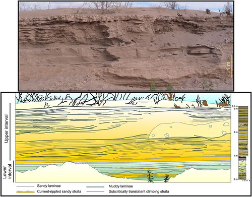
The river banks of the incised dry channel locally expose a sedimentary succession of up to 3.1 m in thickness (Figure 11). The lower interval of the section, up to 1 m (Figure 11(A)), is composed of sandy mud, light brownish grey (7.5YR7/2) or pale reddish orange (2.5YR7/4) in colour, 0.01–0.22 m thick, interbedded with very fine-grained sand, light brownish grey (7.5YR7/2) in colour, less than 1 to 50 mm thick (Figure 12(A)). Sandy mud beds are structureless. The thinnest sandy beds are planar parallel or convoluted; the thickest beds are organized in cross-laminated sets, 20–30 mm thick, commonly climbing and with foresets which indicate southward migration. These beds have tabular geometry, laterally extended more than 350 m. Root traces with partially preserved organic matter are common. OSL dating of a sample at 0.4 m of the section (Figure 11(A)) gave an age of 3.6 ± 0.31 ka (Table 3). The last portion of this interval (at 0.8–1 m in the section) (Figure 11(A)) displays sandy beds with pin stripe laminations (Fryberger and Schenk, 1988), which are overlain by very-fine grained sands with climbing sets with southward directed cross-laminations, and by a muddy lamina, which on the depositional surface exhibits mud cracks with curled-up structures, bioturbation traces, and rain-drop marks (Figure 12(B)). The upper surface of this lower interval is planar and extends laterally for more than 350 m (Figure 11(B)).
| Sample | Th (ppm) | U (ppm) | K (%) | Annual dose rate (mGy/yr) | Accumulated dose (Gy) | Age (years) |
|---|---|---|---|---|---|---|
| LSA | 10.493 ± 0.378 | 2.266 ± 0.044 | 0.133 ± 0.019 | 1650 ± 60 | 6.0 | 3600 ± 310 |
The cross-laminated sandy beds were deposited by southward-directed climbing current ripples; the structureless mud beds, interbedded with the sand, probably were deposited by settling from standing water bodies. Convoluted beds may be due to fluidization of the sand by high pore-water pressure (Allen, 1984) in a water-saturated substrate, whose presence can also be testified by the partial preservation of organic matter of the root traces. Each couplet of sand and sandy mud constitutes an event of deposition in a flooded area whose lateral continuity was far more than 350 m. However, root traces testify subaerial conditions, but with a water table that was near the surface, as suggested by the preserved organic matter and the convolute beds. Near the top of the lower interval (Figure 11(A)) dry wind ripple deposits indicate lowering of the water table and a gradual transition to the upper part. The absence of palaeosols and/or erosive surface suggest that the transition between the lower and upper interval occurred over a short time period. The upper interval of this section (1–3.1 m) comprises beds of sand 0.02–0.5 m thick, which are interbedded with laminae of mud, 1 to 10 mm thick. Most of the sandy beds have a lenticular shape with variable thickness and limited lateral continuity up to 10 m, separated by muddy laminae or erosive surfaces. The dominant sedimentary structure is planar or low-angle (<5°) parallel lamination, which is characterized by thin alternations of medium to fine-grained and very fine-grained sands, less than 1 mm to 10 mm thick (Figure 12(C)). It may be described as subcritically climbing translatent strata. Sandy laminations form sets 0.05–0.35 m thick, which are separated by erosive surfaces, parallel to the overlaying laminations. Mud clasts, up to 10 mm long, are commonly interbedded with the sandy laminations. Less commonly, northward asymmetrical, undulated laminations, up to 5 mm high, and with spacing of 0.1 m may be observed (Figure 12(D)). At times, thin strata, up to 0.25 m thick, of planar laminations with lateral continuity more than 10 m may be observed. One to three sets of fine- or very fine-grained sand with climbing cross-laminations, 5–25 mm thick, and foresets dipping 20–25°, which display asymmetric form sets migrating southwards, commonly overlie the planar or low-angle parallel laminations (Figure 12(C) and (E)). In one case, a bed, 0.25 m thick, with sets of climbing cross-laminations, similar to type B of Jopling and Walker (1968) was observed (Figure 12(F)). A thin lamina of mud overlies these cross-laminations; its continuity is limited to 15 m. On the exposed surface of these laminae, mud cracks, bioturbation, and raindrop imprints are commonly observed (Figure 13(A)). At times, muddy intraclasts or armoured balls are observed on erosive scour surfaces (Figure 13(B)). Bioturbation is common (Figure 12(E)). Buried stumps of bushes in life position, up to 0.3 m high, occur (Figure 11(B)).
The upper interval is composed of a succession of deposits that for the presence of coarser grain size, lenticular shape of the beds and of translatent climbing strata are strongly differentiated from the deposits of the lower succession and similar to the present sand sheet deposits. Most of these beds can be synthesized in a sequence, up to 0.5 m thick, composed for most of its thickness of fine-grained sands organized in cosets of subcritically climbing translatent strata, separated by deflation surfaces, and overlain by a few centimetres of very fine-grained sands with subaqueous current ripples and a lamina of mud (Figure 12(C) and (E)). This sequence represents the construction of a morphological element by the action of wind ripples, which, comparing it with what observed in the current sand sheet surface, can be interpreted as the preserved deposits of a nabkha dune. This is also confirmed by the presence of buried stumps of bushes in life position that constituted the natural barrier downwind of which the nabkha dune was built. In other cases, laterally continuous, planar laminations may be interpreted as subcritically climbing translatent strata and represent wind-rippled mantles. Current ripples and muddy laminae are the depositional product of periodic flood events that inundated the sand sheet surface. The frequent occurrence of muddy laminae indicate that various flooding events alternated with phases of construction of the sand sheet. Along with current ripples and muddy laminae, concave-up erosive surface, at times marked by isolated gravel lags, testify the action of water on a sand sheet area. The thickness of the subaqueous deposits does not exceed 5% of the entire thickness of the upper interval.
Architectural and Depositional Characteristics
The sedimentary succession of the Upper Tulum Valley is characterized by two intervals which represent two depositional systems with different architectural features (Figures 11(A) and 14). The lower interval is composed of tabular strata, more than 350 m laterally extended, deposited by subaqueous flows and it is interpreted as a playa-lake depositional system. The transition to the upper interval is gradual and characterized by interbedding of subaqueous and aeolian deposits. The absence of palaeosols and erosional surface testifies that the environmental conditions changed in a very short time. The upper interval displays sedimentary features similar to the deposits described on the current topographic surface. Thus, it is possible interpret this interval as an aeolian sand sheet. On the current topographic surface, the aeolian deposits are represented by nabkhas, wind-rippled mantles, megaripples, and transverse dunes. In the sedimentary succession only nabkha and wind-rippled mantle deposits have been identified (Figure 14). Megaripple deposits were not found, probably because they are uncommon even on the topographic surface, whereas transverse dune deposits are probably only transitional bedforms and have little chance of preservation. Subaqueous deposits are characterized by current-rippled sandy beds and laminae of mud. Local accumulations of gravel lags of pebbles and armoured balls, and uncommon concave-up erosive scours may testify stronger fluvial currents, whose deposits were reworked by wind activity during the long interval between one fluvial flood and the next.
Tripaldi and Limarino (2008) studied the interaction between aeolian and subaqueous depositional processes in a currently active intermontane aeolian sand sheet, located 200 km north of the Upper Tulum Valley. These authors described a fluvial sedimentary succession, characterized by hyperconcentrated flow deposits, locally forming longitudinal bars, which is interbedded in the fluvial belt area with aeolian deposits, characterized by nabkha, zibar, transverse dunes, and wind-rippled mantles. The influence of the subaqueous processes progressively decreases from the fluvial belt to the interchannel areas, where aeolian processes prevail (Tripaldi and Limarino, 2008). Unlike this example, in the Upper Tulum Valley aeolian sand sheet the volume of subaqueous deposits is extremely reduced, but they are spread over the entire sand sheet area. This aspect has a significant influence on the accumulation of the aeolian system, as discussed below.
A noteworthy aspect is that on the surface of the aeolian sand sheet, soils are not observed, and neither are there palaeosols within the sedimentary succession beneath it. The development of soil depends on climate, biological association, parent material, time, and topography (Jenny, 1941; Catt, 1990; Mack and James, 1992; Retallack, 2001). On the Upper Tulum Valley sand sheet, a relatively diffuse plant cover occurs, the parent material is constituted of lithoarenite sand with dominant volcanic fragments, the mean precipitation of the last 40 years is 194.7 mm y-1. Low rate of precipitations act to curtail the onset of soil formation, but also in arid conditions, with sufficient time in the order of 103 y, poorly-developed Aridisols, incipient soils (Entisols) or, at least, initial processes of pedogenesis, such as destratification or growth of small glaebules, may form in a stable topographic surface (Nettleton and Peterson, 1983; Allen and Wright, 1989; Watson, 1992). The time of deposition of the uppermost 2.7 m of the exposed sedimentary succession is 3.6 ± 0.31 ka (Table 3); this is sufficient time to develop pedogenic features (Allen and Wright, 1989). Nonetheless, no pedogenic or palaeopedogenic features have been observed on the surface or in the sedimentary succession of the Upper Tulum Valley sand sheet, with the exception of bioturbation from roots and animals; on the contrary, the primary sedimentary structures are very well preserved. Thus, it is likely that the main factor that inhibited the soil and palaeosol formation was the instability of the topographic surface. Based on the surface observations and on the interpretation of the sedimentary succession, it is likely that the construction of the sand sheet had been influenced by high-frequency alternating processes of erosion and sedimentation, which created an unstable topographic surface and limited the pedogenic processes to relatively intense bioturbation by plants and animals. These unstable conditions of the topographic surface are demonstrated at the surface by the presence of bedforms which were partially destroyed by floods or wind activity, and in subsurface by common erosive bounding surfaces, mud laminae and presence of buried bush stumps in life position.
Construction, Accumulation and Preservation of the Aeolian Sand Sheet
Several factors influence the construction of an aeolian sand sheet, such as evenly distributed cover of vegetation, presence of coarse-grained sediment, high water table, common floods, which wash away incipient dunes, development of superficial crusts, poor sandy input (Kocurek and Nielson, 1986; Lancaster, 1995; Chakraborty and Chakraborty, 2001; Pye and Tsoar, 2009). Each of these factors serves to restrict the availability of the sand to wind erosion and transport. In the case of the aeolian sand sheet of the Upper Tulum Valley, the style of vegetation cover, the direct and indirect effects of the floods, which rework the dunes, deposit a mud lamina and produce an early cementation of the sand, are probably the main controlling factors.
The construction of the sand sheet occurs due to deposition of sand in nabkha dunes and wind-rippled mantles, and to a lesser extent megaripples and small transverse dunes contribute. The subaqueous processes rework and partially destroy the aeolian bedforms, but they do not contribute significantly to the construction of the sand sheet depositional system. Most of the present sand sheet construction is concentrated along the dry river belt, due to the greater presence of vegetation cover, which decreases the wind velocity and creates shadow zones, and to the airflow disruption and expansion, as observed on the distal part of Sólheimasandur, southern Iceland (Mountney and Russell, 2006).
According to the models of genesis and evolution of an aeolian system suggested by Kocurek (1999, 2003) and Kocurek and Lancaster (1999) the construction of a desert system depends on three factors: wind transport capacity, sediment supply, and sediment availability (Kocurek, 1999). Observation from this study demonstrate that data indicate that the transport capacity of the wind is not a limiting factor in providing sediment for the aeolian sand sheet system. Deposition occurs in response to a localized reduction in the transport capacity of the wind due to the presence of obstacles to the airflow, such as vegetation and terraced river banks, and of expansion areas of the airflow (fluvial bed). The dominant wind observed during the field study comes from SSW, and this direction corresponds well with the main alignment of the nabkhas axes and with the direction of movement of the wind ripples (Figures 4(A) and 7(E)).
The sand, mostly constituted of lithic fragments of volcanic rock, could not have originated from the nearby mountains (Sierra de Villicum and Sierra de Pie de Palo). The former range is characterized by limestone, sandstone, and mudstone, and the latter by high degree metamorphic rocks. Neither do the Mio-Pliocene sediments, which crop out in the area, constitute a source of the sand because they are sheltered by a gravel lag. Thus, the likely source area of the sand is the San Juan fan depositional system, located 45 km SSW from the study area (Lloret and Suvires, 2006; Suvires and Luna, 2008). Indeed, the composition of the sand of the San Juan fan justifies the richness of volcanic fragments of the aeolian sand sheet, as San Juan river has almost 40 000 km2 of catchment area including the Andes Cordillera, where this kind of rock and clastic detritus is very common. The Upper Tulum Valley does not display a significant internal source of sediment (contemporaneous influx). Three main factors inhibit a significant reworking (cannibalism) of the recently deposited sands: (i) the annual floods overlie the entire sand sheet area with a lamina of mud, protecting the previous deposits; (ii) the flood waters, which contain a high percentage of soluble salts due to evaporation, have led to the precipitation of an incipient gypsum cement in the sand deposits; (iii) the vegetation cover binds the substrate and reduces near-surface wind velocity, thereby protecting the accumulation from aeolian deflation. The subaqueous flows generated by the annual no-channelized floods from the adjacent mountains and by the more than 10-yearly fluvial floods do not constitute an appreciable source of sand, because they only partially rework the previous aeolian sediments.
The San Juan alluvial fan is considered the source area of sediment of the Upper Tulum Valley sand sheet. The greater influx of sediment on the fan should occurs during the austral spring and at the beginning of the summer, as the river is supplied by thaw-waters (Figure 15(A)). In this season the sediment availability on the surface of the fan is low due to a high water table. On the surface of the sand sheet, vegetation, mud lamina and cementation inhibit the availability of sediment. These three features mainly operate during the summer when the precipitations favour the growth of the vegetation and cause the floods. On the contrary, in fall and winter the sediment availability increases when the water table lowers on the San Juan fan and floods do not occur on the sand sheet (Figure 15(A)). Wind transport capacity, sediment supply, and sediment availability have been plotted in an idealized sediment state diagram according to the model of Kocurek (1999) (Figure 15(B)). The diagram is constructed according to an annual cycle. It is during the spring and summer that most of the introduction of sediment into the system occurs, but this sediment is only partially available to the wind (CIAL – contemporaneous influx, availability limited) for the reasons discussed above, most of the sand is stored on the alluvial fan (SAL – stored sediment, availability limited). During the fall and winter the availability of the sand increases and the aeolian sand sheet is built using the previously stored sediment (LIAL – lagged influx, availability limited) (Figure 15).
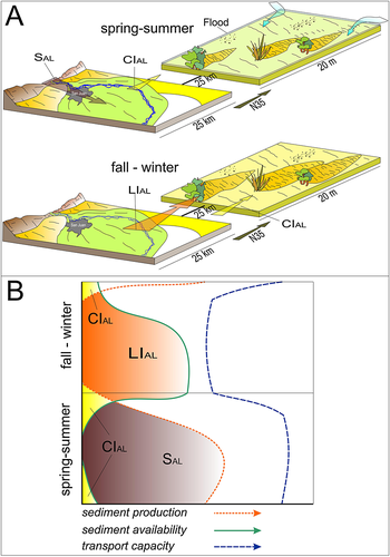
Accumulation occurs as a result of the transition of the constructed sediments below an accumulation surface; for aeolian system this means that accumulated sediments are no longer potentially available for transport or reworking by the wind, thus resulting in stabilization of the strata below the accumulation surface (Kocurek and Havholm, 1993; Kocurek, 1999). Most important factors that result in the accumulation of sediment in the sand sheet of Upper Tulum Valley are related to the floods on its surface. The widespread mud laminae, which overlie all the sand sheet area after each flood, forms a protective film that protects the recently deposited aeolian sand from wind erosion. The importance of this factor in protecting the sediments from erosion is demonstrated by the common presence of mud laminae for a lateral extension of many metres within the sedimentary succession of the sand sheet. The role of the muddy laminae in protecting the aeolian sediments is also recognized by Tripaldi and Limarino (2008) in the sand sheet area of Guandacol Valley, although there the extension of this fine-grained deposit is limited to the area near the dry river channel. In addition, in Upper Tulum Valley, weak cementation of the sand produced by gypsum cement is sufficient to hinder the wind erosion. Thus, the subaqueous processes, although not important for the construction of the aeolian sand sheet, are essential for its accumulation. The presence of vegetation is also a factor that promotes accumulation by means of its effect on air flow deceleration and sheltering from the deflation, but because of its relatively sporadic coverage of the topographic surface it constitutes only a secondary factor.
Preservation is the incorporation of the accumulated sedimentary succession into the geological record (Kocurek and Havholm, 1993; Kocurek, 1999). The preservation of the Upper Tulum Valley aeolian sand sheet is enabled by tectonic subsidence that generate accommodation. This valley is located in an active tectonic area, as indicated by the frequent and strong earthquakes (e.g. the 1944 San Juan devastating earthquake), and it is delimited by active compressive faults (Meigs et al., 2006). Moreover, the considerable thickness of the Mio-Pliocene deposits of the Tulum Valley suggest a relatively rapid time-averaged rate of sedimentation (Servicio Geológico Minero Argentino, 2000; Lloret and Suvires, 2006).
Conclusions
The aeolian sand sheet depositional system of Upper Tulum Valley (Argentina) is characterized by the interaction of aeolian and subaqueous processes. Aeolian processes are dominant throughout the year, although with variable intensity; on the surface, they form nabkhas and wind-rippled mantles, and secondarily megaripples and transverse dunes. Aeolian processes are responsible for the generation of deposits that comprise 95% of thickness of the sand sheet sedimentary succession. The subaqueous processes are characterized by annual floods, originated from the adjacent mountains, which spread over the whole area of the sand sheet. The velocity of non-confined flood water in the study region is so low that the floods only partially rework the previous aeolian bedforms and deposit current-rippled very fine-grained sand, overlain by laminae of mud. Thus, the subaqueous processes do not contribute significantly to the architectural construction of the sand sheet and do not constitute a significant source of sediment. Indeed, most of the sand comes from the San Juan river fan, located 45 km SSW, as testified by the petrographic features and by wind direction.
Figure 15 shows a model of construction of this aeolian sand sheet controlled by seasonal meteorological changes that may be applied in other modern or ancient sand sheets. Source of sediment is the alluvial fan of the San Juan river, which is supplied by thaw-water during the spring–summer. The construction of the sand sheet is mainly active during the fall–winter period, when the lowering of the water table on the alluvial fan and the absence of floods on the sand sheet increase the availability of sediment. Subaqueous deposits and processes have an important role in the accumulation of this aeolian sand sheet. The floods deposit mud laminae over the entire sand sheet area, which forms a protective film and hinders erosion by the wind of the underlying aeolian sand deposits. The style of interbeddings of muddy laminae and aeolian sand strata in the sedimentary succession demonstrates that this process has been common in the construction of the sand sheet. Further, a significant additional role is played by a weak gypsum cementation of the sand due to the saline flood water and by vegetation cover.
The absence of soil on the surface of the sand sheet and of paleosols in the underlying sedimentary succession is unusual because the general conditions required to generate at least an incipient soil exist. Bioturbation and buried small stumps in life-position are the only evidence of pedogenesis or palaeopedogenesis. The absence of palaeosols is interpreted to be a consequence of the instability of the topographic surface of the sand sheet.
The surface of the present aeolian sand sheet is subjected to periodic processes of aeolian deposition and deflation, as also flood events that rework the previous deposits. These processes are recorded in the sedimentary succession by different orders of erosive surfaces and mud laminae. In these conditions of continuous rejuvenation of the topographic surface the likelihood for generating soils is low.
Acknowledgements
The authors would like to thank Fapesp for the financing of this study (Projects 07/00140-6 and 07/02079-2). We are grateful to Carlos Borghi (Universidad de San Juan) for the taxonomic determination of the vegetation and to Arturo Curatola and Andrés for their great hospitality during the field work in the Estancia Don Carmelo (Argentina). Nigel Mountney, Gonzalo Veiga, and the Editors of ESPL are thanked for their helpful comment and observations in reviewing this manuscript. Alicia Reeves is always our ‘English guardian’.


