Simulating the effect of groundwater withdrawals on intermittent-pond vegetation communities
ABSTRACT
Groundwater withdrawals in a shallow unconfined aquifer can reduce water levels in connected wetlands and lead to changes in vegetation. I simulated the effect of withdrawals on the vegetation of intermittent ponds in the New Jersey Pinelands by first characterising the vegetation communities and associated hydrologic regimes of 15 ponds. A model, which was based on these results, was used in conjunction with simulated water-level drawdowns to predict changes in plant communities. Five dominant vegetation communities found at the study ponds included Carex striata, Chamaedaphne calyculata, and Vaccinium corymbosum patch types and aquatic-herbaceous and wetland-herbaceous types, which represent combinations of other vegetation types. A vegetation-hydrology model related mean vegetation cover for the five patch types to water level in 5-cm classes. Groundwater withdrawals were simulated by reducing pond-water depth by 5-cm intervals, and the resulting changes in modelled vegetation were assessed. Aquatic-herbaceous and wetland-herbaceous patch types displayed reductions in area beginning at the smallest simulated drawdowns evaluated. C. striata patch area changed only slightly for drawdowns ≤10 cm, but decreased steadily in response to greater drawdowns. C. calyculata and V. corymbosum patch areas increased for water-level reductions ≤15 cm and then decreased at drawdowns ≥20 cm. The area of combined pond-vegetation types, which represents the entire pond as a single vegetation community, consistently decreased at reductions of ≥10 cm. These simulations suggest that groundwater withdrawals favour the expansion of woody species into intermittent ponds, with eventual replacement of pond vegetation by adjacent forest vegetation if extreme hydrologic modifications occur. Copyright © 2011 John Wiley & Sons, Ltd.
INTRODUCTION
Shallow depressions that support intermittent ponds occur throughout the coastal plain of southern New Jersey (Wolfe, 1953; Lathrop et al., 2005). Hydrologic conditions associated with intermittent ponds in the New Jersey Pinelands are characterised by bankfull or flooded conditions in the early part of the growing season and dewatered conditions in the latter part of the growing season (Zampella and Laidig, 2003). Annual and seasonal water-level variations are associated with the presence of distinct vegetation communities in Pinelands ponds (Zampella and Laidig, 2003). Water-level-related vegetation communities also commonly occur in depression wetlands in other regions of the USA, including pondshores in the northeast (Zaremba and Lamont, 1993), Carolina bays in the southeast (Tyndall et al., 1990; Sharitz, 2003), and prairie potholes in the midwest (Kantrud et al., 1989; van der Valk, 2005). In addition to supporting wetland-shrub and emergent-herbaceous and aquatic-herbaceous vegetation communities, intermittent ponds contribute to regional biodiversity by providing habitat for unusual or rare aquatic and wetland plants (McCarthy, 1987; Zaremba and Lamont, 1993; Kirkman and Sharitz, 1994; Schneider, 1994; McHorney and Neill, 2007). For example, New Jersey locations for Dichanthelium hirstii, a wetland panic-grass and federal candidate species, are currently limited to a few Pinelands intermittent ponds. Pinelands ponds also provide breeding sites for nine native frog and toad species, including the state-endangered Pine Barrens treefrog (Hyla andersonii) (Bunnell and Zampella, 1999; Zampella and Bunnell, 2000; Bunnell and Ciraolo 2010). Although vegetation changes associated with altered hydrologic regimes have been described for ponds in other regions (Zaremba and Lamont, 1993; Sorrie, 1994; Kirkman et al., 1996), no attempts have been made to model potential vegetation changes in intermittent ponds in response to water-level drawdowns from groundwater withdrawals. Furthermore, in contrast to the previously cited studies, ponds associated with undeveloped regions in the New Jersey Pinelands provide a unique opportunity to examine vegetation-hydrology relationships in the absence of confounding factors such as upland agriculture, urban development, and intensive forest management.
Hydrologic conditions in Pinelands wetlands are primarily influenced by groundwater associated with the Kirkwood–Cohansey aquifer, a shallow unconfined system with unconsolidated sediments that underlies most of the Pinelands region (Rhodehamel, 1979a,1979b; Zapecza, 1989). Because of the connectivity between this aquifer and wetlands of the region, groundwater withdrawals from the aquifer can potentially alter the hydrology of adjacent wetlands. In an unconfined aquifer, groundwater pumping lowers the water table within a cone of depression that extends laterally away from the well (Winter, 1988), with direct impacts to wetland hydrology occurring if the cone of depression intersects the wetland. This effect was demonstrated in aquifer tests at two Pinelands locations, where groundwater pumping induced water-level declines in adjacent wetlands (Lang and Rhodehamel, 1963; Charles and Nicholson, ). The direct effects of groundwater pumping in the vicinity of a Massachusetts coastal plain pond underlain with unconsolidated glacial deposits of sand and gravel included reduced year-round pond-water levels and other changes to the hydrologic regime (McHorney and Neill, 2007).
This study on intermittent ponds is one component of a comprehensive project that assessed the potential hydrologic and ecological effects of groundwater withdrawals from the Kirkwood–Cohansey aquifer on various Pinelands aquatic and wetland systems (Pinelands Commission, 2003). In this study, I characterised major vegetation-community types in intermittent ponds and determined what hydrologic regimes are associated with these communities. A vegetation-hydrology model based on these results was then used in conjunction with simulated water-level drawdowns to predict possible shifts in plant communities that may result from groundwater withdrawals. The results of this study have direct applicability for assessing the impact of groundwater withdrawals on pond vegetation in the Pinelands.
MATERIALS AND METHODS
Study-site selection
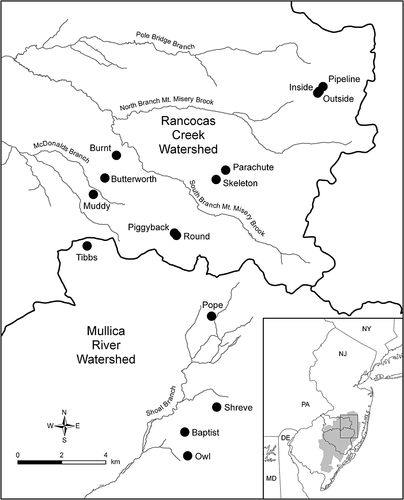
Fifteen intermittent ponds associated with the Rancocas Creek and Mullica River watersheds in the New Jersey Pinelands were selected (Figure 1). The ponds are located on state-owned lands, including Brendan Byrne State Forest, Bass River State Forest, and Greenwood Wildlife Management Area, and are associated with the Kirkwood–Cohansey aquifer system. Site-selection criteria included pond-size diversity, accessibility, the presence of an open-water centre during high-water conditions, and geographic proximity to McDonalds Branch, a small Rancocas Creek tributary where concurrent hydrologic and ecological studies on the Kirkwood–Cohansey aquifer were conducted (Walker et al., 2008; Laidig et al., 2010; Walker et al., 2011; Charles and Nicholson, ). All ponds are situated within extensive upland and wetland forests, with negligible amounts of developed and agricultural lands in the vicinity.
The 15 ponds appeared to be associated with naturally occurring depressions because steeply cut banks, an indicator of human disturbance associated with excavation (Zampella and Laidig, 2003), were absent. All of the ponds were discernable on digital aerial photography representing 1930 conditions (Sass, 1992). Based on a survey of aerial photography from the 1979, 1986, 1991, 1995–1997, 2000, and 2002 periods, there was no evidence of recent significant disturbances such as timber harvesting and wildfire in the immediate vicinity of the ponds.
Hydrologic conditions
Staff gauges were installed at the deepest point in each pond. Same-day and bimonthly (every 2 weeks) water-level measurements were collected at each gauge from March through October in 2005 and 2006. Water-level measurements were collected at least 3 days after a significant rain event (>2.5 cm) and when hydrographs from the nearby McDonalds Branch hydrologic-benchmark station (Mast and Turk, 1999) indicated baseflow conditions. To assess how closely pond-water levels were related, bimonthly water-level values for each pond were correlated with all other ponds using Spearman rank correlation.
To determine if hydrologic conditions associated with the 2005 and 2006 growing seasons differed from long-term conditions, monthly mean-discharge data for the McDonalds Branch hydrologic benchmark station and Mann–Whitney tests were used to compare study-period and long-term stream-discharge regimes. Long-term discharge data included all available growing-season values from October 1953 through October 2004. Discharge data were accessed online from the US Geological Survey Surface-Water Data for USA webpage (http://waterdata.usgs.gov/nwis/sw).
Bathymetry
To obtain pond bathymetry, water depths were measured in March and April 2005 along transects established perpendicular to the long axis of each pond. This period typically coincides with maximum water depth in Pinelands ponds (Zampella and Laidig, 2003). Depending on pond size, transects were established at 5-m or 10-m intervals with 10 to 15 transects in each pond. Water depths were recorded along the transects at three intervals, including 1-m intervals near the pond perimeter (an area often characterised by relatively high topographic relief), 2-m intervals within relatively small vegetation patches, and 4-m intervals in relatively large vegetation patches. A staff-gauge reading was recorded on the day that water-depth data were collected. The locations of water-depth collection points were recorded with a global positioning system (GPS) capable of submeter accuracy and exported to a geographic information system (GIS) to create a water-depth data layer. Raster bathymetric maps were constructed for each pond using the water-depth data layer, ArcView software (Environmental Systems Research Institute Inc., Redlands, CA, USA), and the inverse-distance-squared-weighted-interpolation (IDW) method set to a 1-m output grid-cell size. With the IDW method, water depths for individual grid cells were interpolated from the nearest five water-depth points within a maximum distance of 10 m.
Vegetation-patch delineation and characterization
Patches of homogenous vegetation within each pond were delineated in 2004 with a GPS that recorded positions at 1-s intervals. The location of the pond perimeter, which is defined in this study as the treeline of the adjacent forest, was also recorded. In general, the treeline corresponds to the extent of surface-water area during normal high-water conditions. The geodata were exported to a GIS and used to create pond-perimeter and vegetation-patch data layers.
Using a grid with 100 cross-hair points and the point-intercept method, vascular-plant-species cover and Sphagnum cover were measured in July–August 2005 in 1-m2 plots that were located within the vegetation patches. The number of plots established in the ponds was scaled according to pond area, and ranged from 15 to 87 with a mean (±1 SD) of 44 (±24). With the exception of patches where the density and structure of shrubs precluded access, plots were located according to a stratified-random design to ensure that all types of homogenous vegetation patches within each pond were sampled. The July–August period was selected for conducting cover measurements because many herbaceous species reach full cover at this time. The plots were revisited in October 2005, a period when all but one of the ponds had dried, and the species-cover values were modified if cover increased or if additional species were found. Although I did not attempt to identify Sphagnum species in the 1-m2 plots, I recorded the individual Sphagnum species present in each pond. The cover measurements collected from the 1-m2 plots were used to calculate mean cover for vascular-plant species and Sphagnum for each patch type in the ponds. Taxonomic nomenclature for vascular plants and Sphagnum was based on Gleason and Cronquist (1991) and Crum (1984), respectively. Voucher specimens representing most of the plant species encountered during the study were deposited in the Pinelands Commission herbarium.
Based on mean cover data from the 1-m2 plots, vegetation patches with ≥10% total vascular plant cover were assigned the names of the dominant vascular-plant species present. Patches with <10% total vascular plant cover were classified as mixed-herbaceous. Additionally, those mixed-herbaceous patches and named vegetation patches associated with the open-water centre of the ponds were combined to form wetland-herbaceous and aquatic-herbaceous patch types based on the habitat association (i.e. aquatic vs wetland) of individual herbaceous species present in the patch. Habitat associations were based on descriptions given by Gleason and Cronquist (1991) and Godfrey and Wooten (1979, 1981). Patches were designated as aquatic-herbaceous if the combined cover of aquatic species exceeded that of wetland species, whereas patches supporting a greater relative abundance of wetland species were classified as wetland-herbaceous types. A raster vegetation-patch map with 1-m grid-cell size was constructed for each pond. ArcView software (ESRI Inc., Redlands, CA, USA 1999–2006) was used to create the vegetation-patch map and to calculate the area associated with each vegetation patch in the ponds.
Vegetation-patch water levels
Raster bathymetric maps, raster patch-type maps, and the staff-gauge readings for the measurement date representing the maximum water-depth for the study period were used to calculate summary water-depth statistics for each vegetation-patch type in each pond. Mean water levels at high-water conditions associated with each of the most frequently occurring patch types were compared using Kruskal–Wallis ANOVA. Water levels representing high-water conditions were used because all of the vegetation communities are flooded at this time, allowing for relative water-level comparisons of patch types across the entire pond. Post-hoc comparisons were conducted using multiple comparisons of mean ranks (Siegel and Castellan, 1988). An alpha level of 0.05 was used to identify significant results for all statistical tests.
Vegetation-hydrology model
To assess potential water-drawdown impacts on patch-type area and to have broad applicability to ponds in the region, a vegetation-hydrology model was created. Raster bathymetry maps for each pond were broken into 5-cm water-depth classes. The proportion of area occupied by the individual vegetation patch types was calculated for each water-depth class. The patch-type proportions associated with each water-depth class were averaged across the 15 ponds and were used as probabilities to predict patch-type occurrence for each class (Auble et al., 1994). The area associated with each water-depth class was also calculated for each pond and averaged across the 15 ponds.
Drawdown simulations
Simulated water-level drawdowns, which represent permanent changes to pond water levels, were applied to the vegetation-hydrology model in 5-cm increments up to a maximum of 50 cm. For each of the water-level drawdown simulations, the total area of each patch type was calculated by summing the product of the patch-type probability and pond area associated with each water-depth class. I used graphs to evaluate the change in cover for the most frequently occurring patch types in response to the various water-level drawdown scenarios. I also evaluated the change in the combined cover of all pond vegetation patches because this combined pond-vegetation type serves to represent the entire pond as a single vegetation community.
RESULTS
Hydrologic conditions
Mean monthly growing-season discharge at McDonalds Branch for the study period did not differ significantly from long-term (1954 through 2004) mean monthly growing-season discharge (p = 0.44). This indicates that hydrologic conditions during the study period were similar to long-term conditions.
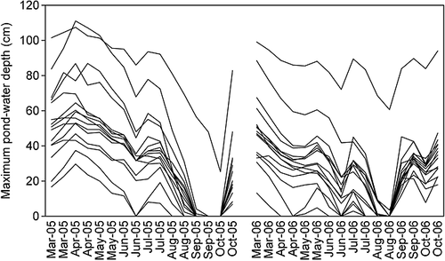
The 11 April 2005 water-level measurement represented high-water conditions for most of the ponds (Figure 2). Maximum pond-water depths for the study period ranged from 30 to 111 cm for the 15 ponds. With the exception of a single pond in 2005 and two ponds in 2006, all ponds dried completely by the end of the growing season in both years. Bimonthly water levels collected on 32 sampling dates were significantly correlated among the 15 ponds (mean ± 1 SD Spearman r = 0.88 ± 0.09, p < 0.05), indicating that the ponds exhibited similar patterns in growing-season water-level fluctuations.
Vegetation
Species inventory
A total of 68 vascular-plant taxa, including 44 herbaceous and 24 woody species, were found at the 15 ponds (Table 1). Herbaceous species that occurred at more than one half of the ponds included Carex striata, Eleocharis flavescens var. olivacea, Drosera intermedia, Nymphaea odorata, Panicum verrucosum, Xyris difformis, Utricularia fibrosa, and Woodwardia virginica. Twenty-four (55%) of the herbaceous species occurred at three or fewer ponds. With the exception of C. striata and U. fibrosa, most herbaceous species were typically characterised by low abundance. Total-species richness ranged from 19 to 43 at the 15 ponds. The majority of the herbaceous taxa were associated with the open-water centre of the ponds. Based on a plant-classification scheme described by Zampella et al. (2006), all of the herbaceous and woody plant species encountered at the ponds are considered native to the Pinelands. Two species listed by the New Jersey Pinelands Commission as threatened or endangered in the region, including Nymphoides cordata, a floating-leaved aquatic, and Rhynchospora inundata, an emergent wetland species, each occurred at a single site in the open-water centre.
| Species | Classification | % | Species | % |
|---|---|---|---|---|
| Herbaceous species | Woody species | |||
| Brasenia schreberi | aquatic | 33 | Acer rubrum | 100 |
| Eleocharis robbinsii | aquatic | 27 | Acer rubrum (seedling) | 27 |
| Eriocaulon aquaticum | aquatic | 7 | Amelanchier canadensis | 40 |
| Eriocaulon compressum | aquatic | 20 | Aronia arbutifolia | 80 |
| Nuphar variegata | aquatic | 7 | Betula populifolia | 13 |
| Nymphaea odorata | aquatic | 60 | Cephalanthus occidentalis | 20 |
| Nymphoides cordata | aquatic | 7 | Chamaecyparis thyoides | 7 |
| Orontium aquaticum | aquatic | 13 | Chamaedaphne calyculata | 93 |
| Juncus militaris | aquatic | 7 | Clethra alnifolia | 47 |
| Proserpinaca pectinata | aquatic | 20 | Eubotrys racemosa | 93 |
| Scirpus subterminalis | aquatic | 7 | Gaultheria procumbens | 13 |
| Utricularia fibrosa | aquatic | 53 | Gaylussacia baccata | 20 |
| Utricularia geminiscapa | aquatic | 40 | Gaylussacia dumosa | 47 |
| Amphicarpum purshii | wetland | 7 | Gaylussacia frondosa | 60 |
| Carex striata | wetland | 80 | Ilex glabra | 73 |
| Cladium mariscoides | wetland | 13 | Kalmia angustifolia | 87 |
| Cyperus dentatus | wetland | 20 | Lyonia ligustrina | 20 |
| Decodon verticillatus | wetland | 27 | Lyonia mariana | 67 |
| Drosera filiformis | wetland | 7 | Nyssa sylvatica | 73 |
| Drosera intermedia | wetland | 73 | Pinus rigida | 100 |
| Dulichium arundinaceum | wetland | 33 | Rhododendron viscosum | 27 |
| Eleocharis flavescens var. olivacea | wetland | 80 | Sassafras albidum | 7 |
| Eleocharis microcarpa | wetland | 40 | Smilax rotundifolia | 87 |
| Eleocharis tricostata | wetland | 13 | Vaccinium corymbosum | 100 |
| Erianthus giganteus | wetland | 7 | Vaccinium macrocarpon | 27 |
| Euthamia tenuifolia | wetland | 7 | Sphagnum Species | |
| Fimbristylis autumnalis | wetland | 7 | Sphagnum angermanicum | 7 |
| Hypericum canadense | wetland | 33 | Sphagnum bartlettianum | 40 |
| Juncus pelocarpus | wetland | 47 | Sphagnum cuspidatum | 100 |
| Panicum longifolium | wetland | 7 | Sphagnum flavicomans | 7 |
| Panicum verrucosum | wetland | 60 | Sphagnum henryense | 13 |
| Panicum virgatum | wetland | 13 | Sphagnum macrophyllum | 7 |
| Panicum spretum | wetland | 27 | Sphagnum magellanicum | 47 |
| Rhexia virginica | wetland | 40 | Sphagnum palustre | 13 |
| Rhynchospora alba | wetland | 27 | Sphagnum papillosum | 13 |
| Rhynchospora fusca | wetland | 13 | Sphagnum pulchrum | 60 |
| Rhynchospora inundata | wetland | 7 | Sphagnum recurvum | 47 |
| Scirpus cyperinus | wetland | 7 | Sphagnum tenerum | 13 |
| Scleria reticularis | wetland | 7 | — | — |
| Triadenum virginicum | wetland | 20 | — | — |
| Utricularia subulata | wetland | 47 | — | — |
| Woodwardia virginica | wetland | 53 | — | — |
| Xyris difformis | wetland | 60 | — | — |
| Xyris smalliana | wetland | 20 | — | — |
Thirteen (30%) of the herbaceous species were classified as aquatic plants (Table 1). These consisted primarily of floating-leaved, submerged, or free-floating plants that are typically associated with standing or flowing water. The remaining species were wetland plants that are typically associated with moist or wet soil of bogs, marshes, wet woods, or swamps.
Twelve species of Sphagnum were found at the 15 ponds, with individual ponds supporting from one to eight species (Table 1). Sphagnum cuspidatum occurred at all of the ponds, and this species appeared to be especially abundant in the open-water centre of the ponds. Three Sphagnum species were uncommon, and each occurred at a single site.
Patch-type inventory
Twenty-five vegetation-patch types were identified at the 15 ponds (Table 2). Patches dominated by Chamaedaphne calyculata and Vaccinium corymbosum, both woody species, and C. striata, a persistent herbaceous perennial, were the most frequently occurring patch types. Most herbaceous-patch types associated with the open-water centre of the ponds occurred infrequently. Based on the relative abundance of aquatic and wetland species, seven of these herbaceous-patch types were combined to form an aquatic-herbaceous type and nine herbaceous patches were combined to form a wetland-herbaceous type (Table 2). Mean ± 1 SD pond area, representing the combined area of all patch types at a pond, was 0.55 ± 0.38 ha (Table 2).
| Baptist (0.55) | Burnt (1.08) | Butterworth (0.64) | Inside (0.33) | Muddy (0.26) | Outside (0.18) | Owl (1.07) | Parachute (1.28) | Piggyback (0.25) | Pipeline (0.24) | Pope (0.39) | Round (0.10) | Shreve (0.85) | Skeleton (0.84) | Tibbs (0.25) | |
|---|---|---|---|---|---|---|---|---|---|---|---|---|---|---|---|
| Herbaceous-patch types | |||||||||||||||
| Mixed herbaceous (W) | — | — | 29.8 | 14.1 | — | 29.8 | — | 52.1 | 30.9 | — | — | — | — | — | 31.4 |
| Brasenia schreberi (A) | — | 6.7 | — | — | — | — | — | — | — | — | 4.8 | — | — | — | 0.3 |
| Carex striata | 22.4 | 47.2 | — | — | 4.5 | — | — | 10.5 | 0.7 | 1.7 | 0.4 | — | 0.3 | 35.9 | — |
| Cladium mariscoides (W) | — | — | — | — | — | — | 13.8 | — | — | — | — | — | — | — | — |
| Decodon verticillatus | — | — | 1.1 | — | — | — | — | — | — | — | — | — | — | — | — |
| Dulichium arundinacea (W) | — | — | — | — | — | — | — | — | — | 11.4 | — | — | — | — | — |
| Eleocharis flavescens (W) | — | — | — | — | — | — | — | — | — | — | — | — | — | 4.8 | — |
| Eleocharis microcarpa (W) | — | — | — | — | — | — | — | — | — | — | — | 18.8 | — | — | — |
| Eleocharis robbinsii (A) | — | 2.4 | — | — | — | — | 67.4 | — | — | — | — | — | — | — | — |
| Eriocaulon compressum (A) | — | 0.5 | — | — | — | — | 1.1 | — | — | — | — | — | — | — | — |
| Hypericum canadense (W) | — | — | — | 26.0 | — | 9.3 | — | — | — | — | — | — | — | — | — |
| Juncus pelocarpus (A) | — | — | — | — | — | — | 3.3 | — | — | — | — | — | — | — | — |
| Nymphaea odorata (A) | 1.0 | — | — | — | — | — | — | — | — | — | — | — | — | — | — |
| Panicum virgatum | — | — | — | — | — | — | 1.0 | — | — | — | — | — | 6.9 | — | — |
| Rhynchospora fusca (W) | — | — | — | — | — | — | — | — | — | — | — | — | 2.9 | — | — |
| Scirpus cyperinus (W) | — | — | — | — | — | — | — | — | — | — | — | — | — | — | 1.4 |
| Utricularia fibrosa (A) | — | — | 17.9 | — | — | — | — | — | — | 39.3 | 84.6 | 61.3 | — | — | — |
| Utricularia geminscapa (A) | — | — | — | — | 57.6 | — | — | — | — | — | — | — | — | — | — |
| Utricularia subulata | 1.8 | — | — | — | — | — | — | — | — | — | — | — | — | — | — |
| Woodwardia virginica | — | — | 5.6 | — | — | — | — | — | — | — | — | — | — | — | — |
| Xyris difformis (W) | — | — | — | — | — | — | — | — | — | — | — | — | 27.7 | — | — |
| Woody-patch types | |||||||||||||||
| Chamaedaphne calyculata | 74.7 | 31.0 | 45.5 | — | 37.9 | 12.8 | 12.6 | 0.3 | 65.7 | 47.6 | 10.2 | 13.8 | 56.2 | 12.2 | 16.2 |
| Ilex glabra | — | 0.6 | — | — | — | — | — | — | — | — | — | — | — | — | — |
| Pinus rigida | — | 0.6 | 0.1 | 1.3 | — | — | — | 0.7 | 1.7 | — | — | — | 1.4 | 1.4 | — |
| Vaccinium corymbosum | — | 11.0 | — | 58.7 | — | 48.0 | 0.7 | 36.3 | 1.1 | — | — | 6.0 | 4.6 | 45.7 | 50.8 |
Based on the relatively low cover of associated vascular species measured in the 1-m2 plots, C. calyculata and C. striata patch types could be characterised as monotypic. Although no 1-m2 plots could be established in V. corymbosum patches because vegetation density precluded access, field observations indicated that this type could also be considered monotypic. Relatively high herbaceous species richness was associated with aquatic-herbaceous (22 species) and wetland-herbaceous (26 species) patch types compared to C. striata (17 species) and C. calyculata (10 species) patch types. A total of 32 herbaceous species were associated with the aquatic-herbaceous and wetland-herbaceous types combined, which represents the open-water centre of the ponds. Sphagnum moss as a group was associated with all of the patch types, and covered ≥20% of the ground layer for 18 of the patch types.
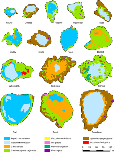
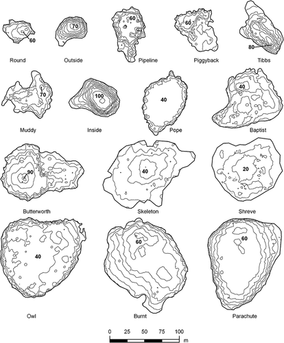
General trends in the arrangement and configuration of vegetation patches were evident at most ponds (Figure 3). When present, V. corymbosum patches typically occurred near the pond perimeter, followed by C. calyculata and C. striata patches toward the pond interior. Although there was no consistent order of the aquatic-herbaceous and wetland-herbaceous patches relative to each other in the four instances where they both occurred, both patch types consistently occurred in the open-water pond interior. Outlines for many vegetation patches appeared to follow bathymetric contours at the 15 ponds (Figures 3 and 4).
Vegetation-patch water levels
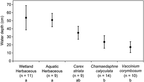
Greatest mean water depths were associated with the aquatic-herbaceous and wetland-herbaceous patch types, followed by C. striata, C. calyculata, and V. corymbosum patch types (Figure 5). This overall trend was also present within individual ponds. A Kruskal–Wallis ANOVA test indicated water level was only significantly different between aquatic and wetland herbaceous and C. calyculata and V. corymbosum patch types (p < 0.01).
Vegetation-hydrology model
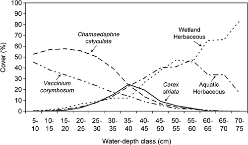
A vegetation-hydrology model relating mean vegetation cover to water level in 5-cm classes was created using the five most frequently occurring patch types (Figure 6). Wetland-herbaceous patch cover generally increased, whereas V. corymbosum patch cover decreased with increasing water depth. Aquatic-herbaceous patch cover increased with increasing water depth up to approximately 55–60 cm and then declined with greater depths. C. striata patch cover increased until 35–40 cm and declined at water depths >40 cm. C. calyculata patch cover remained relatively stable for water depths up to 20–25 cm and then decreased with increasing water depth.
Drawdown simulations
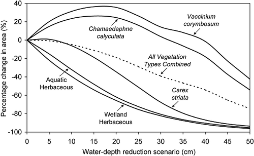
The five dominant patch types showed varying responses to simulated reductions in water-depth (Figure 7). Aquatic-herbaceous and wetland-herbaceous patch types, which represent the open-water portion of the pond, exhibited steady declines in cover that began at the smallest water-level reduction. The C. striata type showed very little change for reductions of ≤10 cm, but steadily decreased for reductions ≥15 cm. In contrast, C. calyculata and V. corymbosum patch-types increased for water-depth reductions ≤15 cm and decreased at water-depth reductions ≥20 cm. These two woody patch types did not decrease beyond initial levels until water levels were reduced by >30 cm for C. calyculata and >40 cm for V. corymbosum. The aquatic-herbaceous and wetland-herbaceous types were the most sensitive of the five patch types to simulated water-level reductions. For example, a 15-cm reduction in water depth corresponded to a 54% decrease in the wetland-herbaceous type and a 48% decrease in the aquatic-herbaceous type, whereas the C. striata type decreased by only 19% and C. calyculata and V. corymbosum patch types increased by 26% and 36%, respectively. A 50-cm reduction in water depth resulted in nearly 100% decreases in aquatic- and wetland-herbaceous and C. striata patch types. The area of combined pond-vegetation types, representing the entire pond as a vegetation community, showed little change at the 5-cm water-depth reduction but consistently decreased at reductions of ≥10 cm.
DISCUSSION
Projected increases in woody patch types and decreases in aquatic-herbaceous and wetland-herbaceous patch types for simulations of water-level reductions ≤20 cm (Figure 7) were generally consistent with reported vegetation changes associated with reduced hydrology in ponds and lakeshores from other areas. For Carolina bays dominated by herbaceous species, drought-induced hydrologic changes led to a decrease in aquatic species and an increase in the abundance of facultative species, including seedlings of tree species (Mulhouse et al., 2005a,2005b). In another set of bays that were examined over a 15-year period that included two drought events, vegetation changes included a decrease in aquatic-plant cover and an increase in woody and upland species after droughts, whereas aquatic species increased and upland and woody species were eliminated during prolonged periods of inundation (Stroh, 2004). Zaremba and Lamont (1993) recorded the incursion of woody species, including Pinus rigida, Acer rubrum, and Clethra alnifolia, and upland species in a New York coastal plain pond after a multi-year drought and noted that all of these plants were killed when high-water conditions returned. Similarly, dense stands of P. rigida saplings became established on some Cape Cod pond shores during a low water-level period because of groundwater withdrawals and low precipitation, with mortality of most saplings recorded after two consecutive years of high water (Craine and Orians, 2004). McCarthy (1987) also noted the establishment of tree and shrub species in two southern Pinelands ponds during a period of water-level drawdown. Models describing lakeshore vegetation patterns that suggest that woody plants are killed by high water levels (Keddy and Reznicek, 1986; Wilcox and Nichols, 2008) are based, in part, on the assumption that lowered water levels allow for woody species colonisation. Similar interactions between water-level and shrubby vegetation have been described for Nova Scotian lakeshores (Keddy and Wishue, 1989). My model predictions, along with observations from the above studies, support the concept that lowered water levels favour the expansion of woody species into the interior of intermittent ponds, and high water levels inhibit shrubs and other woody species from colonising these areas.
The decrease in area of all five individual and combined patch types assumes replacement of areas previously occupied by pond vegetation with adjacent vegetation types because of the modified site hydrology. In the Pinelands, P. rigida lowland forests most commonly occur adjacent to ponds (Zampella and Laidig, 2003). P. rigida lowlands have a mean water level of 55 cm below the soil surface (Laidig et al., 2010), with water levels of 41 and 65 cm for wet and dry lowland types (Zampella et al., 1992), respectively, and lack the standing water that is characteristic of intermittent ponds. Long-term groundwater withdrawals of sufficient magnitude could eliminate standing water in pond areas such that the modified hydrologic regime resembles that of P. rigida lowland forests. Thus, intermittent ponds, when viewed broadly as a single vegetation type, could eventually be replaced by the adjacent forest type under these highly modified conditions. Such large-scale replacement of a vegetation type in depression wetlands has been documented for Carolina bays, where prolonged hydrologic changes brought about by draining were among the factors accounting for the succession of 67 out of 125 herbaceous-dominated bays to hardwood-swamp forests during a 41-year study period (Kirkman et al., 1996).
In the vegetation-hydrology model, where patch cover was related to water level in 5-cm water-level classes (Figure 6), the increase in wetland-herbaceous cover and decrease in aquatic-herbaceous cover at water depths >60 cm was unexpected. These results may be due, in part, to the increased wetland-species cover for annual and perennial wetland species that grew on dewatered substrate in deep-water zones after the ponds dried. Another confounding factor is that, although the patches were defined based only on dominance, often aquatic and wetland species both occurred in the individual patch types that were combined to form the aquatic- and wetland-herbaceous types. The distinction of these patch types based on the dominance of wetland or aquatic species may be unwarranted because no consistent patterns were evident in the relative positions of the aquatic-herbaceous and wetland-herbaceous patches in the four ponds, where both patch types occurred (Figure 3) and because water levels associated with the aquatic-herbaceous patches fell within the range of water levels associated with the wetland-herbaceous patches (Figure 5). Regardless, both aquatic-herbaceous and wetland-herbaceous patch types displayed similar trends (i.e. loss in cover) in response to simulations of decreasing water-level (Figure 7).
Overlapping water-level ranges associated with individual patch types across the ponds (Figure 5) suggest that non-hydrologic factors also may influence the type and extent of vegetation zones in intermittent ponds. For example, variable competitive ability displayed by herbaceous and woody species found in shoreline habitats (Keddy, 1989; Keddy et al., 1994; Gaudet and Keddy, 1995) can affect plant distribution in aquatic and wetland systems (Keddy, 1989; Grace and Wetzel, 1981). Catastrophic fire, a historic and present-day vegetation-shaping force in both uplands and wetlands in the New Jersey Pinelands (Little, 1979; Schuyler and Stasz, 1985), may also influence pond-vegetation patterns. Deep-burning fires in P. rigida lowland wetlands can eliminate trees, wetland shrubs (including C. calyculata), and the peat layer (Schuyler and Stasz, 1985), and allow standing water to develop (Little, 1979). Although I found no evidence for recent (post 1979) catastrophic fire in the immediate vicinity of the study ponds, onsite observations of elevated root crowns of dead V. corymbosum observed in the open-water portion of the shallowest pond in the study suggest that historic fire may have affected the extent of woody vegetation and open-water zones in this pond. Herbivory by deer is another non-hydrologic factor that exerts a large influence on Pinelands vegetation (Wolgast, 1979). Judging from the presence of abundant deer trails and browsed within-pond vegetation at most of the study sites, deer browsing likely affects plant composition and structure in ponds. These non-hydrologic factors, in addition to contributing to observed pond-vegetation patterns, may influence the successional trajectories predicted in our vegetation-change scenarios that were based solely on hydrology changes.
The patch types and associated water-levels observed in this study were comparable with those described for a set of nine natural Pinelands ponds associated with the Kirkwood–Cohansey aquifer located elsewhere in the New Jersey Pinelands (Zampella and Laidig, 2003). In that study, V. corymbosum, C. calyculata, and other woody dominated patches occurred in relatively shallow nearshore areas, C. striata patches occupied areas with intermediate water levels, and various aquatic and emergent types occupied deeper water areas associated with the open-water centre. Although reflecting growing-season hydrologic conditions for an earlier time period (1996–1998), mean ± 1 SD water levels associated with V. corymbosum (24.4 ± 7.7 cm), C. calyculata (26.8 ± 9.4 cm), and C. striata (37.5 ± 5.6 cm) were similar to water levels found in the current study (Figure 5). Because aquatic and emergent patch types in the previous study were classified somewhat differently than in the current study, actual water levels for these patch types were not compared. The similarities in vegetation and water-level relationships between the two sets of ponds suggest that the predicted vegetation changes due to simulated water-level reductions found in this study have region-wide applicability for assessing groundwater withdrawals in the New Jersey Pinelands.
Although the results of this study modelled potential changes in pond vegetation under various simulated water-level declines, actual transitions may display variable lag times depending on the vegetation type. Models for hydrologic impacts on herbaceous lakeshore vegetation demonstrated that species composition changed with the length of time that had elapsed since dewatering, with major changes occurring in the second year after dewatering (Wilcox and Nichols, 2008). Elsewhere, herbaceous lakeshore vegetation assemblages following drawdown shifted in dominance from bryophytes and annuals to perennial herbs to clonal herbs over a 2–3-year period, with the largest changes occurring within the first year of drawdown (Odland and del Moral, 2002). Clonal herbs dominated the vegetation assemblage for the remaining 10 years of the 13-year study, despite the development of relatively low cover of some woody species that colonised the site. Increases in wetland shrub area in response to periods of low water levels in shoreline wetlands associated with the St. Marys River typically occurred within 5 years of drawdown (Williams and Lyon, 1997). Schneider's (1994) flood-history analyses suggested that for trees and shrubs to become established in coastal plain ponds, water-level drawdowns lasting 3–4 years are required. Large-scale transitions from pond-vegetation to forest communities would likely take even longer. Non-hydrologic factors, such as those previously mentioned, may also influence the length of time over which herbaceous-vegetation and woody-vegetation transitions occur after hydrologic regimes have been modified.
Drawdown simulations in this study suggest that groundwater withdrawals from the Kirkwood–Cohansey Aquifer that cause permanent water-level changes in intermittent ponds will alter within-pond vegetation communities. Because of the relatively high species richness of floating-leaved, submerged, free-floating, and wetland plants associated with the aquatic and wetland-herbaceous patch types in the open-water centre of the ponds, large-scale loss of these patch types and associated species would reduce regional biodiversity. Similarly, habitat for rare plants such as Nymphoides cordata and Rhynchospora inundata, which in this study was restricted to the open-water centre of the ponds, would be reduced and replaced by woody cover types. Although species losses associated with monotypic cover types, including V. corymbosum, C. calyculata, and C. striata patches would be relatively less than losses associated with aquatic and wetland patch types, elimination of these distinctly recognisable vegetation communities would also represent a loss in Pinelands biodiversity. Reductions in pond-water levels would also negatively impact characteristic and rare Pinelands frogs by prematurely drying the ponds and eliminating aquatic habitat necessary for larval development and metamorphosis (Bunnell and Ciraolo, 2010). Frog-larval richness, which is positively correlated with emergent herbaceous vegetation cover (Bunnell and Zampella, 1999), would be diminished with losses in herbaceous patch types. Factors that determine the effect of a well on wetland water-levels, including the distance of the wetland to the well, pumping rate, aquifer characteristics, and proximity to a stream or lake, were identified in a related study of the Kirkwood–Cohansey Aquifer (Charles and Nicholson, ). A consideration of these factors in the development and application of wetland-protective criteria for the placement of future water-supply wells will lessen the potential for groundwater-withdrawal impacts to Pinelands intermittent ponds.
ACKNOWLEDGEMENTS
I thank Robert Zampella for contributing to all phases of this study; John Bunnell and anonymous reviewers for providing valuable comments on the paper; Kimberly Spiegel, Jennifer Ciraolo, and Cathy Brown for assisting with the collection of vegetation, bathymetric, and water-level data; Nick Procopio for providing GIS support; Walt Bien for identifying Sphagnum species; and Patrick Burritt and Kate Reinholt for providing assistance with report production. Funding for this study was provided through the Water Supply Fund in accordance with New Jersey Public Law 2001, Chapter 165.


