Estimation of Crop Evapotranspiration Using Satellite Remote Sensing-Based Vegetation Index
Abstract
Irrigation water is limited and scarce in many areas of the world, including Comarca Lagunera, Mexico. Thus better estimations of irrigation water requirements are essential to conserve water. The general objective was to estimate crop water demands or crop evapotranspiration (ETc) at different scales using satellite remote sensing-based vegetation index. The study was carried out in northern Mexico (Comarca Lagunera) during four growing seasons. Six, eleven, three, and seven clear Landsat images were acquired for 2013, 2014, 2015, and 2016, respectively, for the analysis. The results showed that ETc was low at initial and early development stages, while ETc was high during mid-season and harvest stages. These results are not new but give us confidence in the rest of our ETc results. Daily ETc maps helped to explain the variability of crop water use during the growing season. Based on the results we can conclude that ETc maps developed from remotely sensed multispectral vegetation indices are a useful tool for quantifying crop water consumption at regional and field scales. Using ETc maps at the field scale, farmers can supply appropriate amounts of irrigation water corresponding to each growth stage, leading to water conservation.
1. Introduction
Irrigation water is limited and scarce in many areas of the world. Agriculture is the major consumer of fresh water [1, 2], but it is not necessarily used efficiently due to farmers supplying more water than is consumed by the crop. Thus, better estimation of irrigation water requirements is essential to use water efficiently so water is available for use in the future. To achieve water conservation, it is necessary that farmers adopt new technologies for estimating crop water demands more accurately.
Remote sensing is a technology that can estimate ETc at regional and local scale in less time and with less cost [9, 10]. Remote sensing can also estimate crop coefficients based on spectral reflectance of vegetation indices (VIs) [5, 12]. The normalized difference vegetation index (NDVI) is the most common VIs [13]. NDVI takes into account the reflectance of red and near-infrared wavebands [14], where red waveband is strongly absorbed by chlorophyll in leaves of the top layers, while near-infrared wavebands is reflected by the mesophyll structure in leaves, penetrating into deeper leaf layers in a healthy vegetation [15, 16]. High values of NDVI are related to healthy and dense vegetation, which presents high reflectance values in the NIR waveband and low reflectance values in the red waveband [17]. Crop coefficients generated from VIs determine ETc better than a tabulated Kc because it represents the actual crop growth conditions and capture the spatial variability among different fields [2, 18, 19].
Several studies have used multispectral vegetation indices derived from remote sensing to estimate Kc values on agricultural crops including corn crop, for example, in [20–31]. Crop coefficients derived from remotely sensed vegetation index also have used to generate local and regional ETc maps [2, 32–34]; however, in northern Mexico, ETc maps using satellite remote sensing-based vegetation index remain unexplored.
The objectives of this study were to (1) calculate NDVI values for each corn field for each growing season, (2) develop a simple linear regression model between NDVI derived from satellite-based remote sensing and tabulated Kc obtained of alfalfa-based crop coefficient from ASCE Manual 70, (3) generate Kc maps using the linear regression equation obtained between NDVI and Kc values, and (4) create ETc maps with high spatial resolution at regional and field scales.
2. Materials and Methods
2.1. Study Area
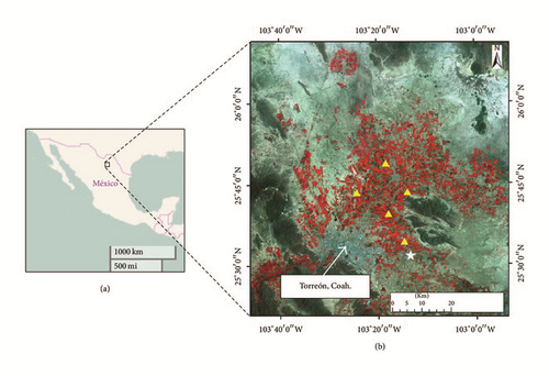
The study was carried out in northern Mexico (Comarca Lagunera) during four growing seasons. Comarca Lagunera had an average latitude of 25°40′ N and longitude of 103°18′ W and elevation of 1115 m above mean sea level (Figure 1). In Comarca Lagunera, forage crops (alfalfa, corn, sorghum, and oat (planted in the winter season)) occupied more than 75% of the total irrigated area [35]. Silage corn is the most important crop after alfalfa in this region. Five silage corn fields in each growing season were selected for NDVI calculations. The corn fields were irrigated using surface irrigation systems. The plant population density was 78,000 plants ha−1. Silage corn is typically planted from late March to early April and chopped for silage from late July to early August, depending on the crop variety. The corn fields selected ranged between 10 and 20 hectares in size. The soil texture for this region is clay loam soil. The mean annual maximum temperature is 28°C, minimum 13°C, and mean 21°C [36]. The mean annual precipitation is 200 mm, while the annual potential evapotranspiration is 2,000 mm [37].
2.2. Landsat Images
Clear sky images from Landsat 7 Enhanced Thematic Mapper Plus (ETM+) and Landsat 8 Operational Land Imager (OLI) and Thermal Infrared Sensor (TIRS) (Path 30, Row 42) were used to estimate NDVI, Kc, and ETc values. The images were downloaded from the United States Geological Survey (USGS) EROS Datacenter. EROS performed the atmospheric corrections on the images. Also the wedge-shaped gaps appearing within the Landsat 7 images as a result of the SLC-off issue were removed using the Imagine built-in focal analysis tool [11]. Six, eleven, three, and seven clear Landsat images were acquired for 2013, 2014, 2015, and 2016, respectively (Table 1). The satellite images were processed using the Model Maker tool of ERDAS Imagine Software.
| Year | Acquisition Dates | DAP | Satellite | Path/Row |
|---|---|---|---|---|
| 2013 | April 14 | 10 | Landsat 8 | 30/42 |
| April 22 | 18 | Landsat 7 | 30/42 | |
| April 30 | 26 | Landsat 8 | 30/42 | |
| May 16 | 42 | Landsat 8 | 30/42 | |
| June 9 | 66 | Landsat 7 | 30/42 | |
| June 17 | 74 | Landsat 8 | 30/42 | |
| 2014 | April 17 | 8 | Landsat 8 | 30/42 |
| May 3 | 24 | Landsat 8 | 30/42 | |
| May 11 | 32 | Landsat 7 | 30/42 | |
| May 19 | 40 | Landsat 8 | 30/42 | |
| May 27 | 48 | Landsat 7 | 30/42 | |
| June 4 | 56 | Landsat 8 | 30/42 | |
| June 12 | 64 | Landsat 7 | 30/42 | |
| June 28 | 80 | Landsat 7 | 30/42 | |
| July 6 | 88 | Landsat 8 | 30/42 | |
| July 14 | 96 | Landsat 7 | 30/42 | |
| July 22 | 104 | Landsat 8 | 30/42 | |
| 2015 | April 28 | 22 | Landsat 7 | 30/42 |
| May 30 | 54 | Landsat 7 | 30/42 | |
| July 17 | 102 | Landsat 7 | 30/42 | |
| 2016 | April 14 | 8 | Landsat 7 | 30/42 |
| May 16 | 40 | Landsat 7 | 30/42 | |
| June 9 | 64 | Landsat 8 | 30/42 | |
| June 25 | 80 | Landsat 8 | 30/42 | |
| July 3 | 88 | Landsat 7 | 30/42 | |
| July 11 | 96 | Landsat 8 | 30/42 | |
| July 19 | 104 | Landsat 7 | 30/42 | |
2.3. Pixel Selection
Ten pixels for each corn field and each season were selected and extracted from NDVI maps. The pixels were located in the center of each corn field for each overpass date during the four growing seasons. The same pixels were observed throughout the corn growing season. We assumed that the pixels are representative of the entire corn field. All corn fields had flat terrain. The number of pixels per year is presented in Table 2.
| Year | Number of pixels |
|---|---|
| 2013 | 300 |
| 2014 | 550 |
| 2015 | 150 |
| 2016 | 350 |
2.4. NDVI Calculations
The NDVI is the difference between near-infrared (NIR) and red waveband reflectances divided by their sum [13]. NDVI values range between −1 and +1, where water presents negative values and dense canopy presents high positive values [17, 38, 39]. The NDVI was calculated for each overpass date and for each growing season using Model Maker tool of ERDAS Imagine Software as shown in the next equations:
Reyes-González et al. [40] made some comparisons of NDVI derived from satellite remote sensing and derived from GreenSeeker in the Comarca Lagunera, Mexico. The results showed that the NDVI values derived from satellite were within 95% of the in situ values (data not shown).
2.5. Crop Coefficient (Kc) Values from Manual 70
The Kc values were taken from ASCE Manual 70 (Appendix E) [7] and were adjusted according to different corn growth stages throughout the growing season. For Kc estimations the ASCE Manual 70 divides the growing season into two periods, namely, percent of time from planting to effective cover and days after effective cover to harvest. The effective cover and harvest of corn in our study occurred around 55 and 105 DAP, respectively, based on the crop phenology.
2.6. Relationship between NDVI and Kc and Kc Maps Development
The relationships between NDVI derived from Landsat images and tabulated Kc’s values obtained from ASCE Manual 70 (Appendix E) [7], corresponding to each satellite overpass date for 2013, 2014, 2015, and 2016 corn growing seasons, were established. These relationships were used to generate a single linear regression equation for entire period of study.
2.7. Reference Evapotranspiration (ETr) Calculations
The meteorological information was taken from an automated weather station. The weather station was located at the National Institute of Forestry, Agriculture, and Livestock Research (INIFAP), Matamoros, Coahuila, Mexico (Figure 1). The ETr values were taken from the weather station, where ETr was calculated using the Penman-Monteith equation [5, 41].
2.8. Crop Evapotranspiration (ETc) Maps
The Kc values from the Kc maps were multiplied by ETr (see (1)) to create ETc maps with high spectral resolution (30 m) for 2014 growing season, using Model Maker tool of ERDAS Imagine Software and ArcGIS version 10.3.1. The ETc maps are generated to monitor the spatial distribution and temporal evolution of the crop water requirements during the growing season.
2.9. Flowchart of ETc Estimation
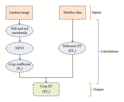
A summary of ETc estimation using satellite remote sensing-based vegetation index is shown in Figure 2. The Landsat images and weather data are the two major inputs parameters in the vegetation index method.
3. Results and Discussion
3.1. NDVI Curves
The NDVI average values (10 pixels) selected and extracted from NDVI maps for five corn fields and for different corn growing seasons are shown in Figure 3. The figures show similar NDVI curves for 2014 and 2016, while, for 2013 and 2015, the curves are incomplete due to lack of clear sky images during the growing seasons. In general, NDVI values at initial stage were low around 0.15 in early April (DAP ~ 8). Then the NDVI values increase as the crop develops reaching its maximum value (0.8) at mid-season stage followed by plateau from late May to middle July (DAP 55–95). At the end of the season the NDVI values are slightly decreasing (~0.7) by the end of July (DAP 105). Several researchers reported similar seasonal NDVI curves for corn (e.g., [17, 20, 24, 30, 42–47]). All NDVI curves developed by these researchers showed low values at early stages, then increasing at mid-season stages and then slightly declining at late stages. However, Thomason et al. [44] reported that NDVI curves of forage corn gradually increased from initial to mid-season and then remained constant until the end of the season.
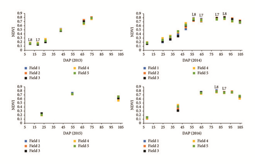
In this study, the NDVI values derived from Landsat 8 (L8) were greater than NDVI values derived from Landsat 7 (L7) in mid-season (Figure 3 (2014 and 2016)) and early stages (Figure 3 (2013)). The differences between L8 and L7 ranged from 0.03 to 0.09 (data not shown). Those differences are in agreement with values reported by Flood [48] (0.04) and Ke et al. [49] (0.06), but greater than reported by Roy et al. [50] (0.02). The difference between L8 and L7 was because L8 has a narrower near-infrared waveband (L7 = 0.77–0.90 μm, L8 = 0.85–0.88 μm), higher signal to noise ratio, and higher 12-bit radiometric resolution [48, 49, 51, 52]. These features provide more precise measurements that are less influenced by atmospheric conditions and more sensitive to surface reflectance [48, 49, 52]. Although the comparison of NDVI between L8 and L7 was not an objective of this study, it is important to mention that inconsistent or unreliable values of NDVI can produce poor estimates of crop evapotranspiration [49].
3.2. Relationship between NDVI and Kc
The NDVI values were taken from NDVI maps generated as an output using Landsat 7 and Landsat 8, while Kc values were taken from ASCE Manual 70 (Appendix E) table for 2013, 2014, 2015, and 2016 corn growing seasons. Figure 4 shows the relationship between NDVI of five corn fields and tabulated Kc values for four growing seasons. Strong relationships were observed for 2013 and 2015 growing seasons, with r2 equal to 0.99, whereas, for 2014 and 2016, r2 was equal to 0.96. The slightly low values of r2 found in 2014 and 2016 seasons, probably was due to major numbers of NDVI values, where some of them were lower than Kc values, especially in development growth stage. Similar values of coefficients of determination (0.99) between NDVI and Kc for corn crop were found by Rocha et al. [53] and Reyes-González et al. [54] but low coefficients were reported by Sing and Irmak [45], Kamble et al. [30], and Toureiro et al. [17], who reported values of r2 to be equal to 0.83, 0.81, and 0.82, respectively.
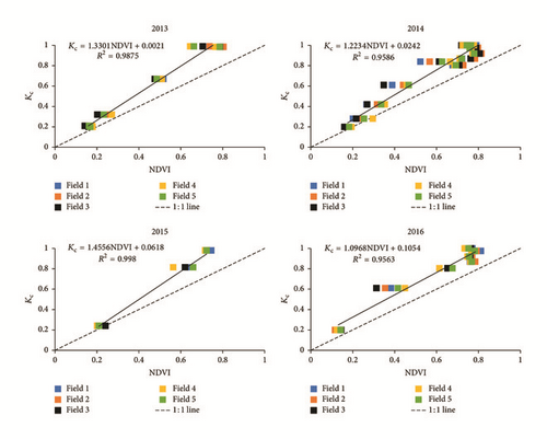
The NDVI computed from Landsat images and Kc obtained from Appendix E of ASCE Manual 70 were used to develop the linear regression equations for 2013, 2014, 2015, and 2016 growing seasons (Figure 4). Those linear regressions were similar to the linear equations of corn reported by other researchers; for example, in [20, 53–55], all these authors used alfalfa-reference crop coefficient and NDVI values for generating linear regression equations.
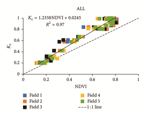
The linear regression equations for the four years were compared using the t-test method to test statistical difference between two independent regressions [56]. Table 3 shows the results of all comparisons, where all t values were less than tabulated t values, which means that there were no statistical differences between linear regression equations. Based on these results all data from the four years were pooled and a single linear equation was generated (Figure 5). This linear equation was used to create Kc maps for 2014 growing season (Figure 6).
| Compared years | t value | t from table |
|---|---|---|
| 2013 to 2014 | 1.14 | 2.16 |
| 2013 to 2015 | 0.96 | 2.57 |
| 2013 to 2016 | 2.13 | 2.26 |
| 2014 to 2015 | 1.53 | 2.22 |
| 2014 to 2016 | 1.08 | 2.14 |
| 2015 to 2016 | 2.31 | 2.44 |
3.3. Kc Maps and Kc Curve
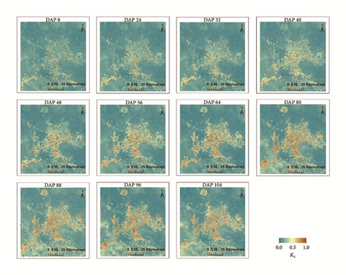
Previous empirical linear equation between NDVI and Kc was used to generate Kc maps using Landsat images processed in ERDAS Imagine Software (Model Maker) for the 2014 growing season. Figure 6 shows spatial and temporal variability of Kc values throughout the 2014 growing season. The Kc maps showed low Kc values early in the growing season (DAP 8) (light blue-green color) and gradually increase at mid-season stage (DAP 56), where plateau remains until harvest (DAP 105) (brown color). Similar Kc maps for corn were developed by Sing and Irmak [45], Irmak et al. [57], Rocha et al. [53], and Reyes-González et al. [54], who reported maps of daily spatial distribution of Kc for six, four, seven, and four overpass dates, respectively. The weather during our 2014 season resulted in usable images for nearly every satellite overpass, on 8-day intervals. These Kc maps show how the Kc values increase (from 0.2 to 1.0) as the silage crop develops.
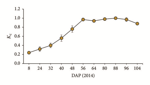
The Kc values obtained from Kc maps based on the average of ten selected pixels within each of five corn fields for each overpass date throughout the 2014 growing season is shown in Figure 7. In general, the minimum Kc value (0.24) was presented in early season, while the maximum Kc value (1.00) was presented in the mid-season stage. The standard deviation (vertical bars) values of Kc were lower than 0.07 throughout the growing season (Figure 7), this means that planting dates, management practice, and maturity dates among corn fields did not affect too much the Kc values during the season.
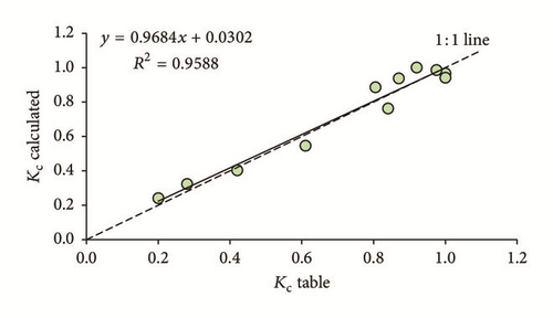
The relationship between Kc calculated from Kc maps and Kc from tables is shown in Figure 8. A strong relationship was found with r2 = 0.96. This means that Kc values derived from vegetation index (Kc calculated) can be a robust parameter to calculate actual crop evapotranspiration. The main difference between Kc calculated and Kc tabulated is that the Kc tabulated comes from well-water reference crop (e.g., alfalfa), whereas Kc calculated comes from the actual crop growth conditions, where some Kc values derived from reflectance of vegetation were reduced by soil water content. Similar results were reported by Singh and Irmak [45] and Kamble et al. [30]. They found that limited moisture content decreased Kc values. Those low Kc values occurred around 15 days previous to start the mid-season stage. In our study the little difference between Kc calculated and Kc tabulated was found in the development growth stage (DAP 40–48) when limited soil moisture content was presented.
3.4. ETc Maps and ETc Values
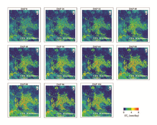
ETc maps of 30 m resolution were generated as an output of Kc maps multiplied by ETr values for corresponding day using ERDAS Imagine Software (Model Maker) for 2014 growing season (Figure 9). The ETc maps showed low ETc values (2.0 mm day−1) (light green color) at initial stage and high ETc values (8.0 mm day−1) (red color) at mid-season stage. These two seasons were characterized because in the initial stage crop needs smaller water requirements, whereas in the mid-season crop needs higher water requirements, as we can see in the next section. The ETc maps created in this study are in agreement with other researchers; for example, in [2, 4, 58, 59], they generated ETc maps using Kc derived from remote sensing-based vegetation indices. Other researchers reported that Kc derived from canopy reflectance based vegetation index had the potential to estimate crop evapotranspiration at regional and field scales, for example, in [17, 18, 29, 55, 60, 61].
3.5. ETc Maps at a Field Scale
ETc maps at filed scale help to explain the variability of crop water requirements during the growing season as shown in Figure 10. These images at a field scale level show the corresponding ETc values according to each growth stage; this indicates that each stage requires different amount of water throughout the season. For example, minimum water requirements (2.0 mm day−1) are needed at the initial stage, whereas maximum water requirements are needed at mid-season stage (8.0 mm day−1). Understating different crop growth stages and applying the accurate amount of volumetric water, farmers can improve their irrigation scheduling, improve water management, and enhance irrigation water sustainability.
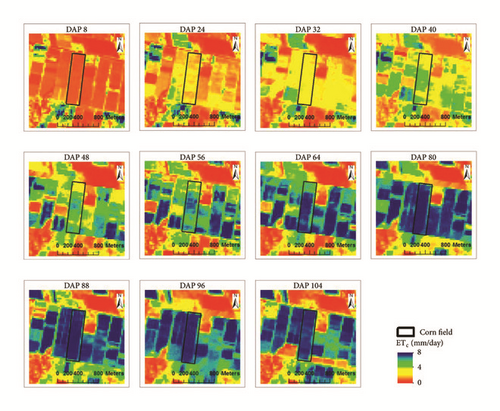
Similar ETc maps at a field scale for agricultural crops including corn were reported by Farg et al. [32], Zipper and Loheide [62], and Senay et al. [63], they reported minimum and maximum ETc values at different crop growth stages, where the higher evapotranspiration rates were found at the mid-season growth stage and lowest evapotranspiration rates were found at early growth stage.
3.6. Comparison between ETr and ETc
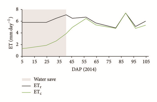
The ETr values were taken directly from a local weather station, while ETc values were derived from ETc maps. Figure 11 shows the comparison between ETr and ETc for 214 growing season. This figure illustrated that the daily ETr values were higher than the daily ETc outputs at the beginning of the growing season, but similar values were recorded at mid-season stage. In early stage (DAP 1–20) the ETr values were around 6.0 mm day−1, while the ETc values were around 2.0 mm day−1. In development stage (DAP 20–55) the ETr values continue around 6 mm day−1, while ETc values increase from 2 to 6 mm day−1. In the mid-season stage (DAP 55–95) both ETr and ETc values were very similar around 7.0 mm day−1. At the end of the growing season (DAP 95–105) the ETr values were slightly greater than ETc values by 0.5 mm day−1. From early to mid-development stage the ETc values were lower than ETr values, this means that in those particular stages farmers can save irrigation water (grey wide column in the graph), because in those stages the crop needs small water requirements, due to the fact that the crop canopy is no yet fully developed. In short, the ETc values from ETc maps could be used by farmers in their irrigation scheduling programs because it shows when and how much water is required by the crop during different growth stages.
Reyes-González et al. [54] reported that the farmers should use ETc instead of ETr for irrigation scheduling in arid and semiarid region where irrigation water is scarce. USDA-NASS [64] reported that the farmers in the United States use four primary methods to determine when to irrigate: the first was visual observation of crop condition method (41%), the second was the soil feel method (21%), the third was personal calendar schedule method (11%), and the fourth was daily crop evapotranspiration method (4%). Methods for deciding when to irrigate need to be more accurate because of the competition for irrigation water increases and its value increases. Farmers must use scientific irrigation scheduling methods (e.g., ET method) instead of empirical methods (e.g., crop condition, feel of soil, and personal calendar) to save water and protect the environment. The ET method is based on climatic demands and is more accurate than empirical methods for irrigation scheduling [65]. ET maps and atmometers are methods to estimate crop water requirements with high accuracy [11].
4. Conclusions
The general objective of this study was to estimate crop evapotranspiration using satellite remote sensing-based vegetation index in northern Mexico.
The relationships between NDVI derived from Landsat images and tabulated Kc obtained from ASCE Manual 70 (Appendix E) were established for four growing seasons. These empirical linear regression equations were used to generate a single linear regression equation.
ETc maps were created as an output of Kc maps multiplied by ETr values. The ETc values ranged from 1.40 to 7.41 mm day−1 during the period of study. The results showed that ETc values were low at initial and early development stages, while ETc values were high during mid-season and harvest stages. Daily ETc maps helped to explain the variability of crop water use throughout the growing season.
Farmers in northern Mexico region use empirical methods in their irrigation scheduling methods. The results indicate that farmers could reduce their seasonal water application amounts by 18% just by using ETc appropriately in their irrigation scheduling methods.
The information generated in this study is essential for irrigation scheduling because it shows when and how much water is required by the crop during different crop growth stages.
According to our results we can conclude that ETc maps developed from remotely sensed multispectral vegetation indices are a useful tool for quantifying accurate crop water consumption or crop evapotranspiration at regional and field scales.
Conflicts of Interest
The authors declare that they have no conflicts of interest.
Acknowledgments
The first author would like to acknowledge the National Council for Science and Technology of Mexico (CONACYT) and the National Institute of Forestry, Agriculture, and Livestock Research (INIFAP) for funding his doctoral scholarship. Additional funding is provided by the South Dakota Agricultural Experiment Station and the South Dakota Water Resources Institute.


