Pattern, prediction and parsimony in continental-scale synthesis of pyromes: a reply to Gosper et al.
Abstract
We (Murphy et al., 2013; Clarke et al., 2015) have recently developed a framework to understand the spatial distribution of fire regimes and plant fire-response traits at large spatial scales. We integrated a range of data sources to create a continental-scale overview of Australian pyromes from which to infer pyrogeographic drivers. Gosper et al. (in press) have criticized our approach, based on our misclassification of a vegetation type (eucalypt woodland), with distinct fire regime, in the Coolgardie bioregion of Western Australia. We argue that the intention of our integrative approach was to develop and refine conceptual models of Australian pyrogeography, not to produce a predictive map of fire regimes, and certainly not to guide local-scale fire management. Like all models, continental-scale syntheses of pyromes are imperfect, yet they still represent powerful tools for understanding the drivers of the spatial distribution of fire regimes.
A basic activity in the discipline of biogeography is the description of the spatial distribution of the biota and ecological processes – including biomes, vegetation types and, increasingly, broad classes of fire regimes – recently called ‘pyromes’ (Archibald et al., 2013; Murphy et al., 2013). Such mapping demands consideration of available data streams, geographic scale, purpose, and underlying ecological theories that collectively frame classificatory units. The recent availability of a range of satellite-derived data sets has driven incredible advances in our ability to consistently describe ecological patterns and processes at vast geographic scales. Globally consistent data sets of tree cover (Hansen et al., 2003), fire activity (Roy et al., 2008), land use (Arino et al., 2008), gross and net primary productivity (Zhao et al., 2005), plus many other variables, are now freely available online. Such data are critical ‘targets’ to calibrate and validate process-based models which help us understand the trajectory of landscapes and ecosystems in response to past and future environmental change. This is especially the case for models describing processes controlling vegetation and fire activity at global scales (e.g. Krawchuk et al., 2009; Hirota et al., 2011; Murphy & Bowman, 2012; Bowman et al., 2014).
In the case of defining pyromes – rather than just simple fire activity – at continental and global scales, there has been significant recent progress based on satellite-derived data products (e.g. global pyromes defined by Archibald et al., 2013). However, many important ecological processes and phenomena remain invisible to air- and satellite-borne sensors, so mapping these at large spatial scales still relies heavily on conventional approaches, such as extrapolating point-based estimates of ecological characteristics across the landscape. Indeed, some components of a pyrome are extremely difficult to infer from satellite-derived information – such as fire intervals (especially when they vastly exceed the duration of the satellite record), fuel types (e.g. grass versus litter) and fine-scale patterns of fire patchiness. Furthermore, it is virtually impossible to directly infer the plant fire-response traits of the entire woody flora (e.g. post-fire resprouting, post-fire seedling recruitment). To advance key questions in the burgeoning field of pyrogeography, we (Murphy et al., 2013; Clarke et al., 2015) have recently taken a more conventional approach to continental-scale synthesis of Australian pyromes. We used a comprehensive vegetation map (National Vegetation Information System, 2006a) as an organizing framework around which to (1) describe the continent's major pyromes and (2) develop conceptual models of their spatial distribution. Such syntheses are important in systematically organizing existing data and framing new pyrogeographic insights, as well as highlighting gaps in knowledge. For instance, the pyrogeographic analyses of Murphy et al. (2013), and others previously, have not grappled with the question of fire season onset, which is critical in evaluating claims that fire seasons are lengthening in response to climate change (Jolly et al., 2015).
Gosper et al. (in press) have criticized our recent syntheses of Australian pyromes (Murphy et al., 2013; Clarke et al., 2015), arguing that we inaccurately described the fire regime and plant fire-response traits of a key vegetation type (eucalypt woodland) in the Coolgardie bioregion of Western Australia. The bioregion's eucalypt woodland is globally significant because it represents the Earth's largest intact temperate woodland. Gosper et al. (in press) convincingly demonstrate that our continent-wide characterizations are a poor match to local observations for this community – underestimating fire intervals, incorrectly characterizing the predominant fuel-type as grass rather than litter, and substantially overestimating the proportional representation of woody plants that resprout following fire. We do not dispute the factual accuracy of Gosper et al. (in press) – our syntheses clearly do not accurately predict the fire regime and plant fire-response traits of eucalypt woodland in the Coolgardie bioregion. However, the key issue raised by Gosper et al. (in press) highlights an important dichotomy in the objectives of biogeographic mapping. Namely, the objective is to either spatially predict the distribution of certain biota or ecological processes (i.e. to produce a map), or to interpret patterns in the distribution of those biota or ecological processes (i.e. to develop or refine conceptual models from that map). Gosper et al. (in press) clearly see our recent descriptions of pyromes as falling into the former category. Although it seems that as predictive maps, our pyrome syntheses have shortcomings – at the very least in the Coolgardie bioregion – we argue that the real value of our work lies in helping to understand the underlying drivers of pyrome distribution by incorporating existing data into a systematic framework.
Since all models are wrong the scientist cannot obtain a ‘correct’ one by excessive elaboration. On the contrary following William of Occam he [or she] should seek an economical description of natural phenomena. Just as the ability to devise simple but evocative models is the signature of the great scientist so overelaboration and overparameterisation is often the mark of mediocrity.
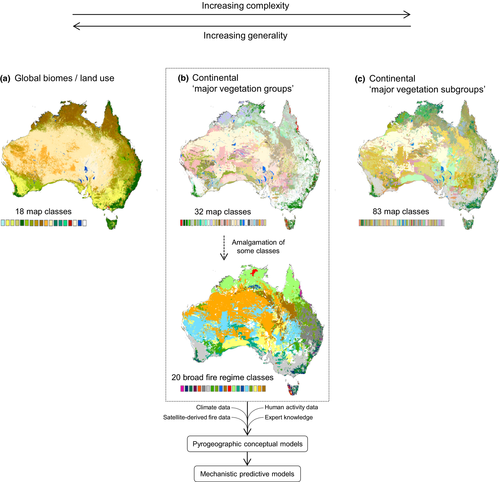
Box's words gave rise to the aphorism that ‘all models are wrong, but some are useful’. We suggest that our models are indeed useful in understanding Australian pyrogeography, and specifically the processes that drive the geographic distribution of pyromes. Decisions are inevitably made regarding the level of precision required of a model, and the extent to which this is traded off against overparameterization (Fig. 1). In the case of our models, this was done using expert elicitation, rather than a formal quantitative analysis.

Gosper et al. (in press) further argue that our results could misinform fire management, because managers could infer that the bioregion's eucalypt woodland can tolerate significant increases in fire frequency. Rather than being misinformation on our part, it seems that if managers were to base fire management prescriptions on a continental-scale pyromes map, that would be a case of mis-use of our work – akin to a seafarer navigating using a small-scale map of the world's oceans, or a national park manager using only a global vegetation map (e.g. Fig. 1a). Gosper et al. (in press) need to acknowledge the limits of the local data they cite, which present managers with substantial ‘blind spots’. They provide no information on how fire regimes have changed in response to climate variability, introduction of domestic livestock and feral herbivores and the cessation of Aboriginal fire management. Various data can be used to estimate these effects although they can't be readily validated or reliably generalized across vast landscapes.
Debates about the scale, accuracy and approaches to biogeographic mapping hinge on the purpose of the mapping exercises. The intent of our integrative approach was to develop and refine conceptual models of Australian pyrogeography, based on spatial representations of key pyrogeographic variables. Such conceptual models are essential for the ongoing refinement of mechanistic predictive models, which provide a pathway to analyse data from other settings, and to incorporate new data within the Australian domain. Emerging pyrogeographic models are critical to understanding climate change and carbon dynamics, especially at the regional and global scales. Clearly, such generic models are of limited value for local-scale management of fire regimes and fire-sensitive biota that demand more detailed local information.
Acknowledgements
Murphy was supported by a fellowship from the Australian Research Council (DE130100434).


