Long-term groundwater resource observatory for Southwestern Madagascar
Abstract
Madagascar has one of the highest poverty rates in the world and consequently the long-term monitoring of groundwater resources is not a priority for the authorities. However, groundwater is often the only sustainable resource that has a satisfactory quality to supply the population. This is especially true in the south-west of the country, which is a semi-arid region and a global change hot spot (intense land use and climate changes). In response to the lack of data, the Groundwater Resource Observatory for Southwestern Madagascar (GROSoM) was established to monitor piezometry and meteorology over the longer term as part of a humanitarian response. The first site was setup in 2014 in a catchment located over a carbonate plateau; in 2018, a second site was installed in an alluvial setting within a crystalline basement catchment and a third site will be installed in 2020 to monitor groundwater dynamics in a coastal setting. The three sites, located between Toliara and Taolagnaro cities, are complementary and representative of various hydrogeological systems in Southwestern Madagascar. Each site includes a weather station and between 3 and 6 piezometric probes. The monitoring data indicate a strong inter-annual variability in precipitation, which induces a strong variability in aquifers recharge. One of the driest years in 2016 seems to be consistent with strong El Niño – Southern Oscillation (ENSO) effects observed at the global scale, while years with higher recharge appear to be related to cyclones such as Fundi in 2015 and Eketsang in 2019. Preliminary results of cross-disciplinary studies demonstrated a link between groundwater and health issues (i.e., admissions to basic health centres). This observatory aims to produce long-term data and has two objectives: (i) strengthening the early warning system for humanitarian crises in Madagascar; (ii) contributing to a better understanding of the effects of climate change on groundwater resources in this semi-arid region.
1 INTRODUCTION
Madagascar has one of the highest poverty rates in the world (World Bank, 2020) and the southwest is the poorest region. This poverty is associated with malnutrition and health issues (UNICEF, 2018; UNICEF, 2019). Consequently, Southwestern Madagascar is regularly in a state of humanitarian crisis (FEWS NET, 2020). However, the origin of these humanitarian crises is still poorly understood and difficult to anticipate. In this semi-arid region, permanent streams are almost non-existent and groundwater is a critical water resource for the population's survival (Guyot, 2002). Numerous hydrogeology projects have been carried out (e.g., André et al., 2005; Carrière et al., 2018; Rabemanana et al., 2005) but the lack of data and the absence of long-term monitoring limit the development of a sustainable groundwater resources management plan. The lack of hydrological data makes it difficult to exploit global hydrological or climatic products (e.g., Beck et al., 2017; Hersbach et al., 2020; Sutanudjaja et al., 2018) because data to validate them in Madagascar are lacking. Drought lowered the water table, reducing well productivity and dewatering others, which increases the pressure on the remaining wells. As a result, the water price increased and the poorest populations have very limited access to water. We hypothesis that a low water table triggers humanitarian crises due to the reduced access to water (hygiene and drinking water) and access to food (crop and livestock development). In addition, Southwestern Madagascar is a climate change hot spot because more intense and frequent droughts are expected (IPCC, 2014). In this context, setting up a groundwater observatory is essential to better understand the origin of humanitarian crises and to unravel the seasonal and long-term effects.
2 METHOD
2.1 Experimental sites
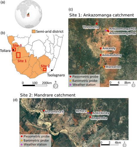
Southwest Madagascar is a semi-arid region of the southern hemisphere and the only rainy season occurs between January and March (Guyot, 2002). The geological formations in the study area are mostly plutonic in the southeast, metamorphic in the northeast, and sedimentary in the west (Besairie & Pavlovsky, 1950). The Groundwater Resource Observatory for Southwestern Madagascar (GROSoM) is composed of three sub-sites located in this semi-arid region (Figure 1). Site 1 is the Ankazomanga catchment, which is devoid of rivers and is located on a carbonate plateau. Site 1 was implemented in 2014 and completed in 2016. The project was part of a hydrogeological study to support the siting of new boreholes during a humanitarian drought response in the region (Carrière et al., 2018). Site 2 is located in the Mandrare catchment near the Mandrare River. It was created in 2018 during a humanitarian drought response following the strong El Niño effect. Site 3, for which funding has been secured, is being set up in 2020/2021 in the coastal zone around Toliara city. The three sites are complementary as they are located in different hydrogeological contexts (plateau, alluvial and coastal) with local climatic variability and different human activities. This diversity makes it possible to better assess the variability of hydrogeological conditions in the semi-arid region of Madagascar.

2.2 Devices and measurement strategy
The GROSoM observatory is equipped with automatic piezometric probes (model Mini-DIVER, marketed by VanEssen Instruments®) allowing an accuracy of ±1 cm H2O. Each site has 1–2 barometric probes (Baro-DIVER) to record the atmospheric pressure variations (accuracy ±0.5 cm H2O) necessary for the compensation of piezometric data. A meteorological station has been installed at each site. The meteorological station (BWS200 model marketed by Campbell Scientific®) allows the measurement of temperature, precipitation, humidity, wind speed and direction. All the equipment is programmed for hourly data acquisition. This time step is a satisfactory compromise between memory saturation, battery durability and observation of natural phenomena. Remote access to the devices cannot be established due to telecom network instability or absence.
The probes in the Ankazomanga catchment were installed in wells and boreholes with depths ranging from 8 to 35 m. In Mandrare catchment the probes were installed in piezometers less than 10 m deep. For each well, the measurements provided by the automatic probes are checked with a depth meter when the sensors are installed and a few months later.
Data are manually collected every three months. These field missions permit maintenance and cleaning of the weather station sensors and the groundwater probes. Manual measurement of the groundwater level ensures the validity of the data. From a logistical point of view, it is not reasonable to plan these field missions with a shorter time step as part of long-term monitoring. The absence of roads makes these sites very difficult to access, particularly during the rainy season.
3 FIRST RESULTS
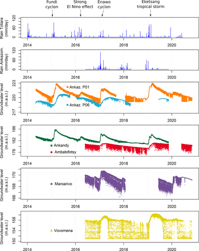
The data from the Ankazomanga catchment have been collected since 2014 (Figure 2). The Toliara rainfall data are from the Toliara airport and not the GROSoM. This station is located 50 km from the Ankazomanga catchment but provides a continuous data series to obtain a wider temporal overview of the climatic observations and to be compared with the GROSoM stations. At the daily time step, a systematic drop in the piezometric level is identifiable due to groundwater exploitation by the local populations. Recharge and discharge patterns vary between the wells, due to difference in well depths and the variability of the aquifers' hydrodynamic properties. It is interesting to observe that inter-annual variability in recharge is strongly influenced by climatic events occurring on a larger scale. The year 2016, which was one of the driest, is associated with a strong El Niño effect observed at a global scale. The years with high recharge are associated with the passage of cyclones and tropical storms. These observations are consistent with those made in East Africa by several authors (i.e., Cuthbert et al., 2019; Kolusu et al., 2019; Taylor et al., 2013).

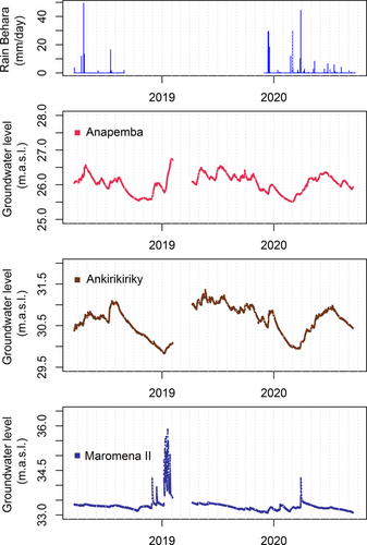
The time series acquired from the Mandrare catchment span more than 2 years (Figure 3). We have a gap in rain data between mid-2018 to end 2019 due to a dysfunction of weather station power supply. We have a gap in 2019 in the piezometric data due to a technical error during data collection. There is no daily piezometric drop because the probes are installed in non-exploited wells. The water table dynamic is variable between wells. The time series of Anapemba and Ankirikiriky have similar dynamics; displaying a jagged and a fairly quick response to rains. However, a fairly strong and smoother recharge occurs between April and July, which does not coincide with the rainy season. We interpret this smoothed and delayed recharge as lateral transfer of water following the flooding of the rivers. The impact of the floods is much more visible on the Maromena II borehole but with a shorter lag. The time series of the Maromena II piezometer resembles a flood hydrograph. This sharp response can be explained by the short distance between the borehole and the Mandrare River bed (less than 50 m) which probably adds to the high transmissivity of the alluvial aquifer and the banks.

Some preliminary results linking groundwater dynamics to population health are encouraging for the transdisciplinary vocation of the GROSoM observatory. A significant anti-correlation with a one-year lag has been demonstrated between the occurrence of low water table level and peak in admission to health centres (Carrière et al., 2019). The high temporal density of the data (hourly time steps) could also allow for more specific analyses to estimate exploited flows in the case of exploited wells or to study tidal effects on unexploited wells (Burgess et al., 2017; Nowreen et al., 2020).
3.1 GROSoM's sustainability challenges
GROSoM's main challenge is its long-term sustainability (>10 years) in a country where 80% of the population lives below the poverty line (World Bank, 2020). Cuthbert et al. (2019) have shown that, given the high interannual climate variability in Sub-Saharan Africa, long-term monitoring (>10 years) is essential to understand groundwater dynamics and thus claim to practice sustainable water resource management.
The project has involved a range of Malagasy actors in the GROSoM through a partnership that aims to support the equipment maintenance, data collection, data and analysis and the reinforcement of partners' capacity. The partnership includes two Universities (Toliara and Antananarivo) because they will train tomorrow's water managers and local institutions DREAH (regional water, hygiene and sanitation department) and the SMR (regional meteorological service) who are institutions responsible for groundwater and meteorology.
We aim to communicate all results to the authorities (e.g., Ministry of Water, BNGRC [national office for risk and crisis management]) in order that decision-makers become familiar with GROSOM and use it as a tool to help them manage water and crisis risks. After each data collection, an information bulletin about groundwater resources situation is sent to the authorities, UNICEF and NGOs operating in the country. The NGO ACF is the lead of a Technical Working Group for Groundwater surveillance and Climate Change (GT-SURECC) containing all the key partners. The group's objective is to support NGO and local institutions to anticipate humanitarian crises linked to water scarcity through a water resources monitoring system. We also seek to integrate GROSoM into international observation networks such as GroFutures (GroFutures, 2021) to increase the visibility of the observatory and facilitate the search for long-term funding.
4 CONCLUSIONS
Improving the population' access to water is a crucial need for Madagascar. To reach this goal, the country must improve water management, which requires a better understanding of groundwater dynamics. The GROSoM is the only long term groundwater observatory in Madagascar. The piezometric data allow a better understanding of the water dynamics and their evolution in the near future (a few months). This knowledge enables the authorities and other NGOs working in the country to better anticipate crises. This observatory set up for the long term (>10 years) and will enable monitoring and understanding of the impacts of ongoing climate change.
ACKNOWLEDGMENTS
The data were acquired through a partnership between the NGO Action Contre la Faim which works against under-nutrition, Avignon University, Antananarivo University, Toliara University, the Ministry of Water, Sanitation and Hygiene (MEAH) and the Malagasy Meteorology Direction (DGM). This work was funded by: foundation SIWA (Sustainable Initiative for Water), foundation Action Contre la Faim for Research & Innovation, DG International Cooperation and Development (DEVCO), Agence de l'Eau Loire-Bretagne (AELB), Agence de l'Eau Adour-Garonne (AEAG), Syndicat Intercommunal Garrigues Campagne, Ville de la Rochelle, Conseil Régional Midi Pyrénées, Office of U.S. Foreign Disaster Assistance and Swedish international development agency.
Open Research
DATA AVAILABILITY STATEMENT
The dataset “Groundwater Resource Observatory for Southwestern Madagascar (GROSoM)” is available on Mendeley at: https://data.mendeley.com/datasets/sndcjn5mc5/draft?a=156849b0-ac6e-4497-a642-0d5b70127efe. The data set is available and updated every 3–6 months at: https://www.actioncontrelafaim.org/en/groundwater-resource-observatory-for-the-southwestern-madagascar/.


