Transience of channel head locations following disturbance
Abstract
We used annual re-surveys of two populations of channel heads affected by a severe wildfire in 2012 to monitor changes in channel head location with time following disturbance. Relative to channel heads in surrounding unburned areas, the median contributing drainage area of burned channel heads decreased by two orders of magnitude immediately after the fire, but then returned to values comparable to unburned areas within four years. We distinguish three types of channel heads. Permanent channel heads, which constitute 4% of the total population, occur in well-developed swales in association with stable features such as bedrock outcrops: these channel heads appear to have been unaffected by the fire. Persistent channel heads, which are 40% of the total population, also occur within hillslope concavities, but the exact location of the channel head moves upslope and downslope through time in response to varying inputs of water and sediment. Transient channel heads form on straight and convex slopes immediately following disturbance, but disappear as regrowth of ground cover limits overland flow and sediment movement. The majority of the position changes for persistent and transient channel heads occurred abruptly when viewed as annual time steps. Copyright © 2017 John Wiley & Sons, Ltd.
Introduction
A channel head marks the upstream boundary of concentrated water flow and sediment transport between definable banks (Montgomery and Dietrich, 1988). As such, a channel head marks an important transition in geomorphic processes between diffuse downslope movement of water and sediment on hillslopes and the start of channel networks. The locations of channel heads have been identified using diverse approaches, including remote methods that rely on assumptions about the position of channel heads relative to inflections in hillslope profiles (Ijjasz-Vasquez and Bras, 1995), direct mapping of channel heads visible on remotely sensed images such as aerial photographs or LiDAR (Heine et al., 2004), or ground-based field identification and mapping (e.g. Montgomery and Dietrich, 1989; Henkle et al., 2011; Jefferson and McGee, 2013). Identifying channel head locations is important in the context of mapping channel extent and characterizing parameters such as drainage density and stream order, and in management contexts such as designating riparian buffers. Field studies in diverse geographic settings indicate that the location of an individual channel head can reflect primarily surface runoff or subsurface flow, with mixed populations of surface- and subsurface-dominated channel heads occurring across spatial scales as small as a single hillslope (Dietrich and Dunne, 1993; Julian et al., 2012; Garrett (2016)). Local features such as bedrock outcrops, changes in bedrock joint geometry, downed wood, or boulders can create sufficient heterogeneity in downslope pathways of water and sediment at the surface or subsurface to promote formation of a channel head (Jaeger et al., 2007; Henkle et al., 2011).
One of the difficulties in both mapping channel heads and understanding the controls on their location is determining how well a channel head identified at any particular point in time represents the average location of that channel head through time. Kirkby et al. (2003) distinguished ephemeral channel heads produced in swales in response to a single storm from permanent channel heads that represent the cumulative impact of the distribution of storms over a period of decades to centuries. Ephemeral channel heads typically form upslope from the permanent channel heads. The exact location of an ephemeral channel head depends on the magnitude of the storm. Istanbulluoglu et al. (2004) modeled the effects of wildfire on slope processes and found that reduced forest cover caused by fires results in increased drainage density via upslope migration of channel heads. Wohl (2013) described a decrease in average contributing area upslope from channel heads in the Colorado Front Range in the months following a severe wildfire. Compared to channel heads on undisturbed hillslopes in the same region, contributing area of channel heads in the burned area was two orders of magnitude smaller. Hyde et al. (2014) also characterized channel head locations after wildfire in five areas of the Northern Rocky Mountains. They found that the threshold for channel initiation via infiltration excess overland flow decreases as fire severity and vegetation disturbance increase. To our knowledge, however, previous studies have not documented the persistence or transience of a population of channel heads following a discrete disturbance such as an intense storm or a wildfire, or examined the influences on channel head persistence or transience.
Wohl (2013) compared a population of 50 channel heads across two burned watersheds to a population of 56 channel heads at undisturbed sites within a similar elevation band in the Colorado Front Range that were described in Henkle et al. (2011). In the two burned watersheds, the primary finding in Wohl (2013) was that mean drainage area above channel heads in the burned zone decreased by two orders of magnitude relative to values for the undisturbed sites. Despite substantial differences in mean basin slope for each of the two catchments in which channel heads were mapped, drainage area above channel heads in the two watersheds did not differ significantly after the fire, likely because of greater surface roughness associated with coarse clasts on the ground surface at the steeper site. In this paper, we use four years of annual re-surveys of the population of channel heads documented in Wohl (2013) to examine changes in the location of channel heads with time following disturbance. We initially hypothesized that at least a decade would be required for median contributing area of the burned channel heads to return to a value comparable to undisturbed sites, but recovery proved to be much faster than we had anticipated.
Study Area
The study area includes two small watersheds within the Front Range of Colorado, USA. The Front Range is underlain primarily by Precambrian-age crystalline rocks (granite, pegmatite, granodiorite, gneiss, schist, and amphibolite), with a large shear zone running through each watershed (Abbott, 1976; Nesse and Braddock, 1989). Bedrock outcrops tend to be densely jointed and hillslopes are mantled with cobble- to boulder-sized clasts. The study watersheds lie within the montane forest zone at elevations of 2000 to 2600 m. Forests are dominated by ponderosa pine (Pinus ponderosa) and Douglas-fir (Pseudotsuga menziesii), but also include aspen (Populus tremuloides), Rocky Mountain juniper (Juniperus scopulorum), lodgepole pine (Pinus contorta), and other woody species (Veblen and Donnegan, 2005).
Mean annual precipitation at the study area averages 450 to 550 mm (Kampf et al., 2016). Stream flow within the montane zone is dominated by snowmelt, but intense rainfall from summer convective storms also occurs at elevations below ~2300 m, creating flash floods with much greater unit discharge than snowmelt floods (Jarrett, 1990). Low severity surface fires historically occurred circa every 10 years in the open pine woodlands of the montane zone, as well as stand-replacing fires at intervals of ~50 to 100 years in the upper montane zone of ~2350 to 2600 m elevation (Veblen and Donnegan, 2005). Fire suppression during the twentieth century likely contributed to the occurrence of the relatively large and high severity fires that have characterized the region since the start of the twenty-first century (Brown et al., 2001).
The two study watersheds lie within the area burned during the 2012 High Park Fire. Initiated by a lightning strike on June 9, 2012, the fire burned ~35 300 ha over the next month, mostly within the mountainous portion of the Cache la Poudre River drainage (Figure 1). The two watersheds in which channel heads were mapped, Skin Gulch and Woodpecker Woods, are both tributary to the Cache la Poudre (Wohl, 2013). The hillslopes on which channel heads were mapped are mostly north-facing and are entirely within severely burned zones in which duff and litter layers of the forest soil were completely consumed and only standing dead trees remained immediately after the fire. Woodpecker Woods received post-fire rehabilitation in the form of hay mulch dropped from helicopters during 2012. Skin Gulch did not receive any post-fire rehabilitation.
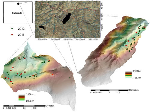
Wohl (2013) was based on channel heads mapped in October 2012, after several convective storms had affected the study watersheds. Precipitation in mountainous regions is highly spatially variable, but colleagues at Colorado State University installed four rain gauges at the Skin Gulch watershed in July 2012 and two rain gauges at Woodpecker Woods in May 2013. As summarized in Kampf et al. (2016), localized convective storms one week after the fire and prior to installation of the Skin Gulch rain gauges caused severe flooding, erosion, and deposition in the mainstem of Skin Gulch. Mean total rainfall for summer 2013 averaged 167 mm in Skin Gulch, which experienced 12 convective storms that resulted in average hillslope sediment yields of 6 Mg/ha. These storms were followed by a large, unusual rainstorm during September 9–17 that produced a mean rainfall of 257 mm in Skin Gulch but created sediment yields of only 3 Mg/ha because of lower intensity rainfalls than the preceding summer 2013 convective rainfalls (Kampf et al., 2016). In Woodpecker Woods, six storms during summer 2013 exceeded a 2 mm-rainfall-threshold for runoff production and the September 2013 storm produced 169 to 180 mm of rainfall (Shahverdian, 2015). The 2013 channel head surveys were completed after the September rainfall. Eight storms exceeded the 2 mm threshold during summer 2014 in Woodpecker Woods, with the largest producing 63 mm of rain on July 29.
Methods
As described in Wohl (2013), we identified channel heads based on signs of sediment transport such as wash marks, small bedforms, and armored surfaces (Dietrich and Dunne, 1993), definable banks, and continuous concentrated flow of water and sediment downstream. In October 2012, we mapped 25 channel heads at Skin Gulch and an additional 25 channel heads at Woodpecker Woods. Each identified channel head was mapped using a hand-held global positioning system with typically ~3 m of horizontal resolution in latitude and longitude. In addition, the position of each channel head was marked using a flagged pin in the ground immediately adjacent along the slope but outside of the channelized area, as well as flagging tied around adjacent tree trunks to facilitate re-location of the channel head. Most of the channel heads mapped in October 2012 were abrupt features with a single, well-defined surface drop from a diffuse swale into a distinct channel.
We judged the contributing drainage area for each field-surveyed channel head, as indicated on 10 m digital elevation models (DEMs) using geographic information system (GIS) software, to be inaccurate due to inappropriate resolutions for the features we had mapped. Consequently, we manually outlined contributing area and local hillslope gradient on 1:24 000 topographic base maps using hillslope topography and field observations, and calculated drainage area on this basis.
We subsequently returned once each year during 2013–2016 to map the channel heads. We returned annually to each location mapped as a channel head the year before. During the annual re-surveys, we remained within the geographic area defined by the spatial extent of the initial 25 channel heads at each of the two sites. However, because channel heads disappeared through time, the total number of channel heads decreased significantly over the entire study period. During each of the annual re-surveys, we visually estimated percent and type of ground cover in the area immediately around the channel head and within the upslope contributing area. We manually determined drainage area for channel heads mapped in 2016 using a method similar to that used for channel heads mapped in 2012 to facilitate comparison between those groups.
We performed statistical comparisons between groups of channel heads to determine how burned channel head drainage area compared to similar unburned sites mapped by Henkle et al. (2011) and how drainage area for channel heads mapped in this study changed from 2012 to 2016 following the High-Park fire. Statistical analyses were performed using the R statistical package (R Core Team, 2015). We used a 99% confidence level for determining statistical significance. Samples of channel head drainage areas were found to be dominantly non-normal (skewed towards high values) through examination of histograms and Shapiro–Wilk tests (Shapiro and Wilk, 1965) (p values all <0.001 except for channel head drainage areas mapped in 2016 in Skin Gulch). To accommodate for this non-normality, we used non-parametric Wilcoxon rank sum tests (Wilcoxon, 1945) to evaluate differences between groups.
We evaluated differences in drainage area between channel heads mapped in 2012 and 2016 in Skin Gulch and Woodpecker Woods separately as well as across both basins. We also performed pairwise comparisons with a Bonferroni correction on a sample that spanned both Woodpecker Woods and Skin Gulch of 2012 (n = 50) and 2016 (n = 22) drainage areas along with drainage areas for similar, unburned sites from Henkle et al. (2011) (n = 32). We restricted the sites used from the Henkle et al. (2011) dataset to those that fell within the same range of elevation as sites in Skin Gulch and Woodpecker Woods due to the suggested correlation between elevation and drainage area required for channel head initiation (Henkle et al., 2011).
Results and Discussion
Table 1 summarizes changes in median contributing drainage area from the start to the end of the study. The 2012 values differ significantly (p < 0.0001) from those for undisturbed areas with a similar elevation in the Front Range (Henkle et al., 2011). Within four years of the fire, median contributing drainage area for channel heads at Skin Gulch and Woodpecker Woods had increased by 4700% and 2400%, respectively. These values differ significantly from the median values immediately after the fire. They do not differ significantly from channel heads in undisturbed areas.
Average percent of the ground surface covered by some type of vegetation (grasses, herbaceous plants, woody shrubs, sapling trees) increased through time at both sites, although rate of change and total vegetation cover by 2016 were greater at the Skin Gulch site (Table 2). Woody shrubs and sapling trees regrew preferentially in concave portions of hillslopes, with sapling aspen (Populus tremuloides) particularly abundant by 2016 in concavities that support seeps or springs.
| Year | Skin Gulch | Woodpecker Woods | All Burned | Henkle et al. (2011) unburned sites |
|---|---|---|---|---|
| 2012 |
750 (430–1395) |
1500 (215–2600) |
1075 (50–1505) |
28 000 (166 000–67 100) |
| 2016 |
34 993 (12 470–99 780) |
45 730 (8310–60 980) |
41 570 (12 470–60 980) |
| Year | Skin Gulch | Woodpecker Woods | ||
|---|---|---|---|---|
| Sample size | Average ground cover (% veg) | Sample size | Average ground cover (% veg) | |
| 2012 | 25 | 0 | 25 | 0 |
| 2013 | 25 | 34 | 28 | 22 |
| 2014 | 15 | 49 | 27 | 30 |
| 2015 | 8 | 74 | 19 | 51 |
| 2016 | 8 | 78 | 15 | 62 |
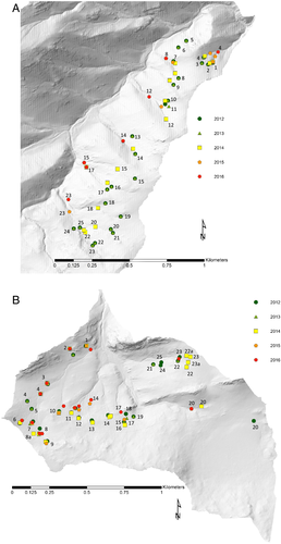
Based on the patterns of changes in channel head locations through time, we distinguish three types of channel heads in the study area during 2013–2016: permanent, persistent, and transient channel heads. Two permanent channel heads at Woodpecker Woods (channel heads 3 and 7, Figure 2) did not change location during the five annual re-surveys following the 2012 fire. These channel heads are located in well-defined, linear hillslope concavities and correspond to fixed local heterogeneities in the form of bedrock outcrops. The channel heads correspond to intermittent or ephemeral streams mapped on 1:24 000-scale US Geological Survey topographic maps and were likely in the same location prior to the 2012 fire. Initial drainage areas were 8310 and 40 000 m2, respectively, which are within the range for other channel heads in 2012, although 40 000 m2 is the second largest value at Woodpecker Woods (Supporting Information Figure S1). Our designation of permanent channel heads equates to what Kirkby et al. (2003) described as permanent channel heads.
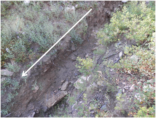
The 20 persistent channel heads (seven at Skin Gulch, 13 at Woodpecker Woods) are also located within hillslope concavities, but they changed location substantially during the years following the 2012 survey. In most cases these channel heads moved progressively downslope. Five channel heads moved farther upslope in 2013 or 2014, in response to very small debris flows, before moving downslope again. We inferred the presence of debris flows based on trench-like channels incised into the hillslope and small debris-flow-style levees along the side of these channels (Figure 3). We designate these channel heads as persistent because a channel head is likely to be present at some location within each of these hillslope concavities, although the specific location varies through time in response to changing water and sediment fluxes down the slope and along the channel.
Changes in location among persistent channel heads appear to reflect very site-specific controls, as indicated by the fact that only five of the total population of 20 persistent channel heads moved upslope after 2012. We could find no correlation or consistent pattern between proportion of change in drainage area between 2012 and 2016 in relation to average gradient of the contributing area or recovery of vegetation. Channel heads with very small drainage areas in 2012 showed the greatest increase in drainage area by 2016 (Supporting Information Figure S2). Changes also occurred in a very episodic manner, within the constraints imposed by annual surveys (Supporting Information Figure S3). That is, channel heads typically remained in the same location for two or three years and then migrated far downslope between annual surveys.
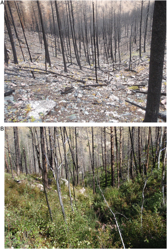
Twenty-nine of the original 50 channel heads were transient channel heads located on straight or convex portions of hillslopes. These channel heads were noticeable during the 2012 survey, but typically disappeared in either 2014 or 2015. We infer that these channel heads formed only as a result of enhanced runoff and sediment movement during the period before vegetation regrew at the burned sites. As herbaceous and small woody plants regrew (Figure 4) and created greater surface roughness and sediment cohesion, declining water and sediment inputs presumably failed to maintain the transient channel heads. Three new channel heads also formed at Woodpecker Woods in 2014 but all were gone by the following year (Figure 2).
Field observations provide some insight into the processes that caused channel heads to change location with time. Sub-meter-scale erosional and depositional features present on the hillslopes in the study area indicate the movement of sediment downslope via processes such as dry ravel and localized sheet wash. Where burned logs are oriented perpendicular to the downward gradient of a hillslope, a small terrace is typically present, with sediment deposited on the upslope side of the log and a vertical drop on the downslope side of the log. Similarly, large boulders and the basal stems of woody shrubs accumulate sediment on the upslope side. Herbaceous plants began to regrow in less than a year after the fire (Table 2) and woody shrubs and sapling trees began to appear within two years after the fire. Although the presence of increasingly continuous vegetation cover presumably limited the magnitude and distance of downslope sediment transport, sufficient sediment movement occurred to begin to fill the upper portions of the ephemeral channels formed immediately following the 2012 fire. A common scenario among the persistent and transient channel heads was that the upslope portion of the channel became discontinuous, with very small (≤ 20 cm) headcuts along the hillslope separated by unchannelized surfaces. Under this scenario, we moved the designated channel head to the upslope-most point with continuously channelized flow. Even the substantial rainfall of September 2013, which caused extensive erosion and deposition in downstream portions of the channel network, had little observable effect on the channel heads. This likely reflected the combined effects of relatively low precipitation intensity and shielding and stabilization associated with vegetation regrowth. Small woody shrubs and sapling trees growing directly within hillslope swales were likely particularly important in helping to stabilize sediment and obliterate channelized erosion within the swales. By 2015 this type of vegetation was so dense in portions of the catchment with small seeps that it became extremely difficult to re-locate marked channel heads.
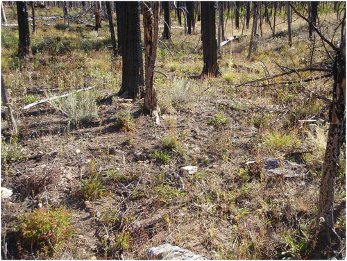
Another process that may have contributed to downslope movement of channel heads was exhaustion of the supply of colluvium stored on hillslopes. In this context, a comparison of the responses of channel heads in Skin Gulch versus Woodpecker Woods is useful. Average basin slope above the channel heads in Skin Gulch is 47%, whereas basin slope averages 27% in Woodpecker Woods. In 2012, the surface was noticeably more coarse-grained in Skin Gulch (Figure 4A), with very little sediment finer than pebble size remaining at the surface. The abundance of cobble- to boulder-size clasts and bedrock outcrops at this site presumably limited subsequent upslope migration of channel heads or formation of new channel heads during the September 2013 rainfall. In contrast, Woodpecker Woods continued to have sand- to pebble-size sediment exposed in unvegetated areas as of 2016 (Figure 5), although vegetation completely covered some areas. This may explain why the number of channel heads present at Woodpecker Woods increased slightly after the September 2013 rainfall (Table 2), and remained double the number mapped for Skin Gulch by 2016.
The use of hay mulch to limit surface erosion in Woodpecker Woods had no detectable effect on the formation or persistence of channel heads. Instead, we attribute differences in number of channel heads through time between Skin Gulch and Woodpecker Woods to differences in average hillslope gradient and substrate grain size.
The rate of channel head adjustment following disturbance presumably reflects the persistence of the changes in rainfall–runoff relations caused by the disturbance. A landslide that completely removes hillslope regolith and leaves bare bedrock slopes would likely cause a more persistent change than a wildfire, for example, and regions or specific portions of a catchment in which vegetation regrows faster will presumably have more rapid return of channel heads to locations with drainage areas comparable to those present prior to the disturbance.
Conclusions
In summary, hillslope topography and substrate characteristics can provide useful insight into the likely permanence of channel heads in a region prone to episodic disturbances. Channel heads present on straight or convex portions of hillslopes are likely to be transient features that will be obliterated by deposition or regrowth of vegetation within a few years of a disturbance. Channel heads present on hillslope concavities are more likely to be permanent features, especially if a relatively stable feature such as a bedrock outcrop or very large boulder sufficiently disrupts downslope fluxes to create a channel head. In the semi-arid conifer forest in which we documented channel heads following a wildfire, return to pre-disturbance values of median contributing area and hillslope location of channel heads occurred within four years, largely as a result of rapid regrowth of herbaceous and small woody vegetation.
Acknowledgements
The authors thank two anonymous reviewers and Stuart Lane for helpful comments on the manuscript. The authors also thank the USDA Forest Service and Roosevelt National Forest for permission to access the study areas immediately after the 2012 wildfire.


