Unconformity generation and the shift from storm-dominated to tide-dominated processes in a Jurassic retroarc foreland basin: Insights from ichnology
Abstract
An enigmatic transition from the storm-dominated, offshore to lower shoreface deposits of the Redwater Shale Member (Sundance Formation) to the overlying mixed tidal and aeolian Windy Hill Sandstone (Morrison Formation) in the Oxfordian of the North American Western Interior has long been a source of intrigue. Previously proposed drivers include the progradation of a large, tide-dominated delta onto a storm-dominated shelf, a complete reorganisation of the basin's hydrodynamics and climate, or the development of a regional unconformity (termed the J-5). In south-eastern Wyoming, the Redwater Shale is characterised as an offshore to distal shoreface deposit with glauconitic siltstones and sandstones punctuated by coquinoid and sandy tempestites and hosting a Cruziana Ichnofacies. The Windy Hill Sandstone, a time-transgressive, sand-rich, intertidal succession with classic Pteraichnus and stressed Skolithos Ichnofacies, sharply overlies the Redwater Shale and records an abrupt basinward shift in facies that accompanied at least tens of metres of sea-level fall. New, detailed sedimentological, ichnological and architectural data collected across this transition in the study area provide fresh insights into the depositional history of these units and demonstrates the existence locally of a composite J-5 unconformity. The unconformity developed as tectonically driven, prograding shoreline trajectories of the Redwater Shale gave way to degrading trajectories of the Windy Hill Sandstone, leading to a forced regression and formation of a regressive surface of marine erosion. The sharp juxtaposition of intertidal flat facies (Pteraichnus Ichnofacies) directly upon offshore to lower shoreface deposits (Cruziana Ichnofacies) is the key to recognising the unconformity and proves the value of the previously underutilised ichnological data.
1 INTRODUCTION
Epeiric or epicontinental seas have few modern analogues yet they were important physiographic features with unique physicochemical properties throughout the Palaeozoic, Mesozoic and early Cenozoic (Brand et al., 2009; Danise et al., 2020; Holmden et al., 1998; Petersen et al., 2016). Deposits of the Middle-to-Late Jurassic (Bajocian-Oxfordian; ca 170–157 Ma), North American epicontinental seaway (Sundance Sea) preserve important palaeontological and economic resources, however, they have not received the same intensity of sedimentological, ichnological and geochemical investigations as their Cretaceous equivalents. Recent studies of the palaeoecology, sequence stratigraphy and palaeogeography of the Middle-to-Upper Jurassic deposits have begun to address some of its unique features (Danise et al., 2020; Danise & Holland, 2017, 2018); although ichnology has until now, remained an untapped source of palaeoenvironmental and process sedimentological proxy data.
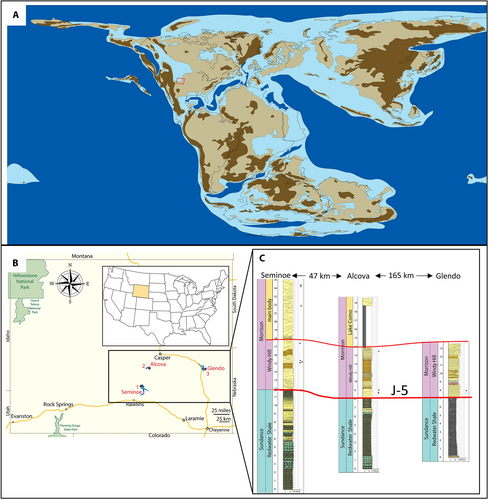
Unlike its Cretaceous counterpart, the Sundance Sea was physically restricted, with limited access to the nearest open marine basin (the proto-Pacific Ocean) and is generally reconstructed with a geographically constricted connection along its north-western margin (Figure 1). This physical restriction is hypothesised to have resulted in strong temperature and salinity gradients with limited circulation during much of the Jurassic (Danise et al., 2020; Danise & Holland, 2017; McMullen et al., 2014; Stanley, 2010). Geochemical evidence of isotopically lighter sea water during the Callovian was interpreted as resulting from an increase in the volume of freshwater runoff (Danise et al., 2020). However, oxygen isotope data from bivalves collected from the Oxfordian Redwater Shale (Sundance Formation) and Windy Hill Sandstone (Morrison Formation) in Wyoming, USA, contradict the purportedly extreme restriction of the Sundance Sea. These oxygen isotope data record values that are close to the Tethyan standard, suggesting that there was less restriction of the Sundance Sea during the Oxfordian relative to earlier in the Jurassic (Danise et al., 2020). Detailed ichnological analysis of these deposits offers a novel means to test hypotheses of restricted versus more open connection to the proto-Pacific.
A regional framework of Jurassic unconformities, numbered from J-0 to J-5 in ascending stratigraphic order, was established by Pipiringos and O'Sullivan (1978) for correlation across the Western Interior of the United States. The J-0 unconformity marks the base of the Glen Canyon Group and equivalent Nugget Sandstone in Arizona, Colorado, Idaho, Nevada, New Mexico, Utah and Wyoming (Pipiringos & O'Sullivan, 1978); the J-1, primarily observed in Wyoming and locally in Idaho and Utah marks the contact between the overlying Gypsum Spring Formation and underlying Nugget Sandstone (Pipiringos & O'Sullivan, 1978). In southern and eastern Wyoming, the J-2 unconformity marks the base of the Jurassic succession, recording fluvial incision and the deposition of mixed aeolian and tidal sands within palaeovalleys (Ahlbrandt & Fox, 1997). The J-3 unconformity is restricted to the southern reaches of the Western Interior, underlying the Curtis Formation in the San Rafael area of central Utah; it is a composite feature including allocyclic and autocyclic erosional segments (Pipiringos & O'Sullivan, 1978; Zuchuat et al., 2019). The J-4 and J-5 unconformities mark the boundaries between the lower and upper Sundance Formation, and the Sundance to Morrison Formation respectively in South Dakota, Wyoming, Utah and Colorado (Figure 2). The J-5 unconformity is generally recognised as separating the Redwater Shale Member and older members of the Sundance Formation from the Windy Hill Sandstone of the Morrison Formation (Pipiringos, 1957; Pipiringos & O'Sullivan, 1978; McMullen et al., 2014; Meyers & Breithaupt, 2014; Uhlir et al., 1988), although its existence has recently been challenged (Danise & Holland, 2018; Holland & Wright, 2020; Kowallis et al., 1998).
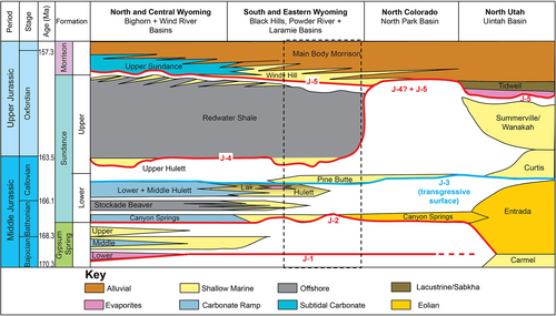
The transition from the storm-dominated, offshore marine Redwater Shale Member to the intertidal Windy Hill Sandstone has historically been interpreted as regionally unconformable (Pipiringos, 1968; Pipiringos & O'Sullivan, 1978; McMullen et al., 2014; Meyers & Breithaupt, 2014; Uhlir et al., 1988), although recent work has suggested it may be a conformable succession (Danise & Holland, 2018; Hasiotis, 2004; Holland & Wright, 2020; Kowallis et al., 1998; Maidment & Muxworthy, 2019). Either model has major implications for the palaeogeographical and sedimentary processes at play during the Oxfordian (i.e. the former suggests a regional forced regression of a storm-dominated coastline with periodically enhanced tidal activity in coastal lagoons versus the normal regression of a single, large, tide-dominated delta onto a storm-dominated coastline that is implied by the latter). Although these interpretations are end members, they may not be mutually exclusive as it is possible that the J-5 is a composite surface that includes both unconformable and conformable segments along its geographic extent. This hypothesis is supported by recent research on the J-3 unconformity (Zuchuat et al., 2019) and other marine to fluvial transitions that contain composite sequence boundaries (Holbrook & Bhattacharya, 2012; Holbrook & Miall, 2020; van Yperen et al., 2020).
To test the hypotheses that the Sundance (Redwater Shale) to Morrison (Windy Hill) transition was conformable and that the marine palaeoenvironments of the Oxfordian Sundance Sea were less physicochemically restricted than many palaeogeographical models suggest, outcrops spanning this time interval were examined in detail at three locations in south-eastern Wyoming: Glendo, Seminoe and Alcova reservoirs (Figure 1). At each locality, the outcrop exposure is good to excellent, with road cuts and the winnowing action by fluctuating lake levels at Glendo and Seminoe reservoirs providing enhanced accessibility for both hands-on and unmanned aerial vehicle (UAV) investigation. The outcrops at Glendo Reservoir are accessible only by watercraft and have therefore received very little previous attention. Those at Alcova Reservoir are relatively poorly exposed when compared to Glendo and Seminoe, however, they are laterally continuous for 6.75 km and represent a more basinward reach of the depositional system. Detailed ichnological and sedimentological analysis of these three localities helps to resolve the enigmatic juxtaposition of strongly tidal and storm-dominated successions, provides insight into the final retreat of the Sundance Sea, and proves the value of ichnological data as a proxy for physicochemical conditions that can be tested with, and bolster, geochemical and sedimentological data sets.
The purposes of this paper are: (1) to describe and interpret the sedimentology of the Redwater Shale to Windy Hill Sandstone transition at three localities in southern Wyoming; Alcova, Glendo and Seminoe reservoirs; (2) to describe and interpret the ichnology and ichnofacies of these outcrops; and (3) to integrate sedimentological and ichnological data with stratigraphic observations to test the hypothesis that the contact between the two members was conformable and provides evidence for progradation of a large, tidal delta into the storm wave-dominated Oxfordian seaway.
2 GEOLOGICAL SETTING AND BACKGROUND
The Middle-to-Upper Jurassic (Bajocian-Oxfordian; ca 170–157 Ma) North American epicontinental Sundance seaway transgressed older Jurassic aeolian deposits and fluvially incised Triassic red-beds within a developing retro-forearc basin (Ahlbrandt & Fox, 1997; Bjerrum & Dorsey, 1995; Brenner & Peterson, 1994; Danise & Holland, 2018; Fuentes et al., 2011; Lawton, 1994). The generally ramp-like setting of the basin was interrupted by palaeobathymetric high spots such as the ancestral Front Range in Colorado, the Sheridan Arch in northern Wyoming, the Black Hills uplift in South Dakota, and the Emery and Uncompaghre uplifts in western Colorado (Ahlbrandt & Fox, 1997; Carpenter, 2022; Danise & Holland, 2018; Imlay, 1957; Parcell & Williams, 2005; Peterson, 1954a, 1954b, 1957; Schmude, 2000). The deepest part of the basin was along the western margin, where the Utah-Idaho Trough formed in response to tectonic loading by a fold and thrust belt in central Nevada, Idaho and Utah (Danise & Holland, 2018). Dynamic topography may have contributed to subsidence as indicated by the greater width across the basin in Wyoming and Montana compared to areas north and south (Fuentes et al., 2011; Heller et al., 1986). Lateral facies variability and differing sedimentation rates across palaeobathymetric highs and lows challenge basin-wide and sub-regional correlation, making it difficult to establish consistent stratigraphic nomenclature (Danise & Holland, 2018; Johnson, 1992; Pipiringos & O'Sullivan, 1978).
The best exposures of the entire Jurassic marine succession in southern Wyoming are found on the shores of Glendo and Alcova reservoirs along the North Platte River (Figure 1). At these locations, Middle (Bathonian) through Upper Jurassic (Oxfordian) strata record a complex, 9 Myr transition from the mixed aeolian/tidal incised valley deposits of the Canyon Springs Member of the Sundance Formation through to the mixed tidal/aeolian lagoonal deposits of the Windy Hill Sandstone of the Morrison Formation (Figure 3). Detailed sedimentological (including ichnological) analysis and stratigraphic logging of the outcrops at Glendo Reservoir reveals a clastic sand-dominated succession that contrasts with the carbonate-rich deposits of the same age, 190 km to the north-west in the Bighorn Basin (Figure 2; Danise & Holland, 2017, 2018; Kilibarda & Loope, 1997).
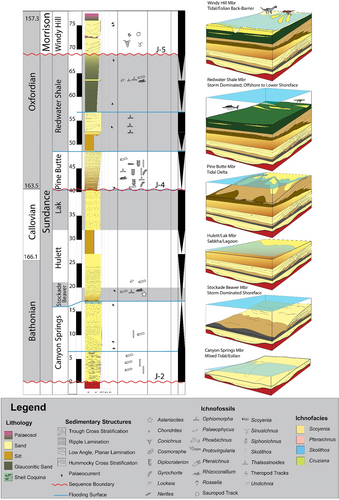
At Glendo and Alcova, the Pine Butte Member represents a tide-dominated, deltaic system as demonstrated by its more heterolithic, rhythmically bedded deposits and ichnofossil suites that are dominated by Diplocraterion and other traces typical of tidal environments (Figure 3; see Cornish, 1986; Higgs & Higgs, 2015; Mángano & Buatois, 2015; Martin et al., 2015). This transitions upwards into the ripple-laminated to massive-bedded Hulett and Lak members, both of which were deposited in physicochemically stressed sabkhas and lagoons with limited ichnological diversity aside from bivalve resting traces (Lockeia) and limited, surface traces such as Gyrochorte (see Johnson, 1992). The Redwater Shale Member chronicles a major transgression of the seaway followed by progradation of storm-dominated offshore and lower shoreface deposits that are recorded by distinctive sedimentary structures (hummocky and swaley cross-stratification; HCS and SCS respectively), centimetre to decimetre-thick shell coquina beds, and characteristic ichnofossil assemblages (robust Cruziana Ichnofacies) that are typical of offshore to distal lower shoreface environments (Figure 3). Finally, the shallow subtidal to intertidal Windy Hill Sandstone with abundant dinosaur and pterosaur tracks (Pteraichnus) marks an abrupt shift from offshore marine to onshore tidal flat deposition preceding the aeolian and fluvial accumulations of the main body of the Morrison Formation (Figure 3).
The Windy Hill Sandstone marks the transition from marine to continental deposition in the Oxfordian and was originally considered to be restricted to south-eastern Wyoming (Brenner & Davies, 1973). It is composed of quartz-rich, very fine-grained, rippled to parallel laminated beds interlaminated with silt-prone intervals (Brenner & Davies, 1973). Similar deposits in Utah's Uinta Basin were assigned to the Windy Hill Sandstone and underlie the Tidwell Member of the Morrison Formation (Carpenter, 2022; Sprinkel et al., 2019). Bioclastic macroforms and coquinoid beds are common in the Upper Sundance Formation in the Wind River and Bighorn basins of central and northern Wyoming and were lumped together with the Windy Hill Sandstone by Holland and Wright (2020). Their lithological distinction from the Windy Hill Sandstone warrants maintaining these deposits as separate units, so they are herein referred to as Upper Sundance Formation per the work of previous researchers (Brenner & Davies, 1973, 1974; Uhlir et al., 1988).
3 MATERIALS AND METHODS
Outcrops were documented through hands-on sedimentary logging (at centimetre-scale, recording grain size, lithology, sedimentary structures, stratal surfaces, ichnofossils, lateral bed terminations and cementation type) and photography that used both handheld digital cameras and UAV's. Individual blocks of sandstone that had dislodged from the outcrop were examined in detail for bedding plane sedimentary structures and surface traces. Bedding surfaces and stratal contacts were walked out, and digital photographs were used to construct panels that permitted the interpretation of facies assemblage architecture. These panels were calibrated using sedimentary logs that were measured through their component outcrops on the ground.
The glauconitic, siltstone and very fine-grained sandstone that constitute the bulk of the Redwater Shale weathers into poorly exposed, vegetated and talus-covered slopes, with notable exceptions where roads have been cut or wave activity in reservoirs with fluctuating water levels keep exposures clear. For these reasons, ichnological assessment of the outcrops at Seminoe and Glendo is more easily accomplished than at Alcova, where neither road cuts nor wave action helps to provide fresh exposures.
More than 430 UAV photographs were used to build a detailed virtual outcrop model of the Redwater Shale-Windy Hill succession at Seminoe Reservoir, covering a 40 m long, 20 m thick and 10 m wide outcrop; imagery was collected using a DJI Phantom 4 Professional drone. The images were captured every 2 s by a UAV flying 0.2 m s−1 at an elevation <3.5 m above the outcrop surface, and the total flight time was 0.5 h. Following collection, the images were processed into a single three-dimensional photogrammetry model using the workflow of Chmielewska et al. (2020) in Agisoft Metashape, and were later interpreted in LIME (Buckley et al., 2019). The model resolution allows for the observation of sedimentary features that are <2 cm across permitting direct comparison to the outcrop sedimentary logs. The virtual outcrop model captures both the map view and section view of the outcrops.
4 RESULTS
4.1 Sedimentology
Fourteen lithofacies (A-N) were recognised in the Redwater Shale and Windy Hill Sandstone in the study area based on lithology, grain size, sedimentary structures and ichnology (Table 1). These lithofacies were then grouped into 12 facies associations which correspond to depositional environments as summarised in Table 2. When combined with the ichnofacies analysis, these facies associations form the basis for reconstructing local and regional changes in dominant sedimentary processes, water depth and physicochemical conditions such as salinity stress, rate of sedimentation and nutrient and oxygen content of marine waters.
| Facies | Description | Sedimentary structures | Grain size | Ichnology | Interpretation | Member |
|---|---|---|---|---|---|---|
| A | Bioturbated, glauconitic siltstone and sandstone. Camptonectes valves are common on sandy bedding planes | Structureless to faintly laminated | Si-VF | Chondrites on some surfaces (distal Cruziana Ichnofacies) | Offshore deposits, accumulated below fairweather wave base, locally with storm-delivered sand and shell material | Redwater Shale |
| B | Heterolithic: carbonate (shell coquina) and glauconitic, siltstone, very fine-grained sand, laterally continuous across the outcrops and not contained within channel scours. Individual coquina beds are sharp-based and flat to slightly scoured, 3–30 cm thick | Massive to poorly laminated | Si-VF | Chondrites, Rhizocorallium and Thalassinoides on upper surfaces of storm beds (Cruziana Ichnofacies) | Offshore to distal lower shoreface storm beds, deposited between fairweather and storm wave base | Redwater Shale |
| C | HCS and SCS sand with little or no carbonate cement | HCS, SCS, parallel lamination, some asymmetrical ripples at tops of beds | VF | Chondrites, Rhizocorallium, Thalassinoides, Rosselia, Nereites, Lockeia, Phoebichnus (Cruziana Ichnofacies) | Tempestites formed by storm wave orbitals in the lower shoreface and offshore environments between fairweather and storm wave base | Redwater Shale |
| D | Symmetrically rippled, glauconitic sand | Symmetrical ripple lamination | VF | Chondrites, Lockeia, surface trails | Formed above fairweather wave base (5–15 m) by weak, oscillation currents | Redwater Shale |
| E | Burrowed, silty sand | Structureless to faint lamination | Si-VF | Skolithos, general bioturbation (Skolithos Ichnofacies) | Slack-water deposition of fine-grained material in subtidal and quiet water environments | Windy Hill |
| F | Wavy to parallel laminated, heterolithic siltstone and very fine-grained sandstone | Parallel laminae, wavy bedding, some asymmetrical ripples | Si-VF | Uncommon Skolithos, escape structures | Subtidal lagoon or tidal flat deposits, including parts of tidal mouth bars | Windy Hill |
| G | Clean, quartz-rich, very fine-grained contorted sandstone | Contorted | VF | dinosaur tracks associated with some, no traces with others | Dewatering and compaction caused by biogenic activity and slumping/compaction | Windy Hill |
| H | Cross-bedded, very fine to fine-grained sandstone with uni- or bidirectional orientation of foresets and silt or clay drapes occasionally preserved on foresets | Tabular, sigmoidal, and trough cross bedding with combined flow ripples at top | VF-F | None or simple Skolithos-like vertical tubes (Skolithos Ichnofacies) | Subtidal dunes with dominant and subordinate currents accumulated on tidal flats and in shallow tidal creeks | Windy Hill |
| I | Cross-bedded, very fine- to fine-grained, clean sandstone with unidirectional foresets. Can occur in scour-contained channelforms | Trough and tabular cross bedding | VF-F | Traces absent | Migrating, subaqueous dunes | Redwater Shale, Windy Hill, main body Morrison |
| J | Clean, rippled, very fine-grained sandstone, deposited in horizontal beds | Oscillation, current, combined flow, and interference ripples, some with flat crests or washouts | VF | Pterosaur tracks, Sinusichnus (Pteraichnus Ichnofacies) | Current and oscillation ripples formed above fairweather wave base, some with microbial mat and occasional supratidal winnowing of ripple crests | Windy Hill |
| K | Rippled, very fine-grained sandstone with shell fragments on parting lineations, arranged into 0.75–1 m thick macroforms with low angle accretion sets dipping oblique to palaeoflow as indicated by ripple crests | Asymmetrical and symmetrical ripples, interference ripples | VF-F | Conichnus, dinosaur tracks (Skolithos Ichnofacies) | Shallow, subtidal to intertidal lateral accretion sets | Windy Hill |
| L | Horizontal to low angle, planar sandstone | Horizontal or gently dipping, parallel laminations | VF-F | none | Upper flow regime in subaqueous setting. | Redwater Shale, Windy Hill |
| M | Heterolithic: massive mudstone and dm-thick sandy lenses contained in channelform scour | Structureless and contorted bedding due to bioturbation | Cl-F | Dinosaur tracks, Scoyenia (Scoyenia Ichnofacies) | Abandoned channel fill composed of flood deposits and subject to subaerial exposure | Windy Hill/basal Morrison |
| N | Clean, large-scale cross-bedded, very fine-grained sandstone | Inverse-graded, pin-stripe lamination with locally contorted bedding | VF | Dinosaur tracks | Subaerial avalanching on aeolian dunes | Main body Morrison |
| Facies association | Description | Interpretation | Facies included | Member |
|---|---|---|---|---|
| FA 1 | FA 1 consists of poorly exposed, easily weathered siltstone and very fine-grained, planar laminated to massive, glauconitic sandstone that is best exposed along the road cut at Seminoe Reservoir and on the cliffs at Glendo | FA 1 is interpreted as an offshore deposit that accumulated below and at times, just above storm wave base. The prevalence of glauconite in this facies association is suggestive of low rates of deposition in shallow marine settings (Hesse & Schacht, 2011; Velde, 2014) | A, B | Redwater Shale |
| FA 2 | FA 2 is a coquinoid carbonate, composed of Camptonectes and other marine invertebrate skeletal elements. It has a planar to scoured base and the upper surface may contain sand and robust Rhizocorallium Thalassinoides, and other burrows. It is represented in the upper 9.5 m of the Redwater Shale at Seminoe and the upper and lower part of the Redwater at Alcova | FA 2 is interpreted to be storm beds of reworked shell material delivered offshore by wave incision and transport (Fürsich & Oschmann, 1986) | B | Redwater Shale |
| FA 3 | FA 3 is composed of HCS, SCS, horizontal to low angle laminated, and rippled sandstone. Ripples cap some HCS and SCS and robust burrows like Thalassinoides and Rhizocorallium occur at the tops of beds. It is present in the upper Redwater Shale at Seminoe and in the lower most exposures at the cliffs on Glendo Reservoir | FA 3 is interpreted as a storm-dominated, lower shore face deposit. The very-fine-grained sandstone beds with HCS and SCS are diagnostic of sediment reworking by storms, below the reach of fairweather waves (Dumas & Arnott, 2006; Peters & Loss, 2012) | A, B, C, D, I | Redwater Shale |
| FA 4 | FA 4 is a platy-appearing, laminated to rippled to cross-bedded, quartz-rich sandstone with some silty parting lineations and abundant Pteraichnus | FA 4 represents intertidal flats that accumulated in back-barrier lagoon. Evidence of rhythmic alteration of flow strength, and subaerial or very shallow subaqueous exposure during accumulation is consistent with deposition on tidal flats and the presence of microbial mats (Cuadrado et al., 2021) | E, F, G, H, I, J | Windy Hill |
| FA 5 | FA 5 is a poorly exposed, recessive unit composed of siltstone and very fine-grained sandstone with laminated and wavy bedding | FA 5 accumulated in mid-flat parts of tidal flats and stratigraphically overlies FA 4 and FA 6 | E, F | Windy Hill |
| FA 6 | FA 6 is sandy, heterolithic, parallel to ripple laminated, horizontal to shallowly dipping very fine-grained sandstone and silt-prone sandstone | FA 6 is interpreted to be the lower part of a tidal mouth bar or bar fringe (see Tye & Hickey, 2001; van Yperen et al., 2020 | E, F, G | Windy Hill |
| FA 7 | FA 7 is similar to FA 3 but the rippled beds are arranged into low angle accretion sets dipping oblique to palaeocurrent vectors as indicated by ripple crests. The sand bodies are 0.5–1 m tall. Dinosaur tracks, Conichnus, and some pterosaur tracks are present in the deposits at Glendo | FA 7 accumulated as subtidal bars with long axes (crests) aligned parallel or oblique to palaeoflow direction (Olariu et al., 2012). The presence of dinosaur and pterosaur tracks requires shallow subtidal to supratidal exposure, suggesting the tops of these bars are not truncated and that maximum flow depths were not much greater than the bar height | E, G, J, K | Windy Hill |
| FA 8 | FA 8 is a cross-bedded, very fine to fine-grained sandstone with a sharp base that can be traced laterally for 10s to 100s of metres. Beds can be arranged into simple or compound bedsets and palaeocurrents are uni- or bidirectional | FA 8 accumulated as subtidal and intertidal dunes arranged into simple or compound dunes (see Olariu et al., 2012). The dunes are not contained within channels and probably accumulated in tidal scours within a back-barrier lagoon | E, F, G, H, I | Windy Hill |
| FA 9 | FA 9 is composed of massive to contorted, dark greyish-green or oxidised, silt and silty sandstone contained within broad, shallow scours. It contains dinosaur tracks and is burrowed and occurs at the top of the Windy Hill at Glendo and Seminoe | FA 9 represents episodic flooding and sediment delivery within avulsion- abandoned fluvial or tidal channels that were at times, subaerially exposed (see Toonen et al., 2011) | E, F, J, L, M | Windy Hill/basal Morrison |
| FA 10 | FA 10 is preserved at the base of the main body of the Morrison Fm at Seminoe Reservoir. Clean, quartz-rich, cross-bedded sandstone with some iron staining on foresets and toesets. Grain flow layers on some foresets | FA 10 is interpreted to represent wind-blown slip faces of subaerial dunes (Davies, 1997; Hasiotis, 2004) | I, N | Main body Morrison |
| FA 11 | FA 11 is a structureless, dark greenish-grey, silty sandstone with some claystone | FA 11 is interpreted to be overbank deposits of coastal fluvial channels or brackish water lagoons (Connely, 2006) | E | Main body of Morrison (Lake Como Member) |
| FA 12 | FA 12 is variable and consists of pink, orange, and red-coloured, oxidised claystone, siltstone, and sandstone with contorted to massive bedding. It is present at the contact between the Windy Hill and the main body of the Morrison at Glendo and Seminoe but has not been recognised at Alcova | FA 12 is a product of subaerial weathering of previously deposited sediment and represents palaeosol (Tabor & Myers, 2015) | M, N | Windy Hill/basal Morrison |
4.1.1 Facies association 1: FA 1—description
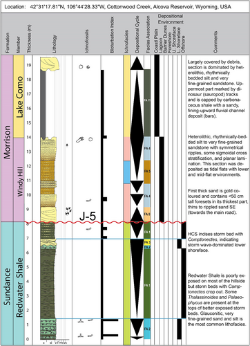
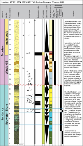
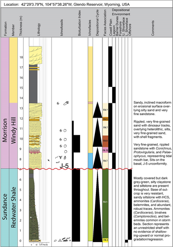
Facies Association 1 is composed of facies A and constitutes the bulk of the Redwater Shale at all three localities; it is best exposed at the roadcut at Seminoe Reservoir (Figures 4-6 and 7A). Facies Association 1 weathers recessively and is composed of intercalated siltstones and very fine-grained, glauconitic sandstone that has varying amounts of cementation and biogenic structures. The well laminated sandstone is interbedded with structureless, silt-prone sandstone and local beds that contain faint lamination, which suggests varying intensities of biogenic activity related to physicochemical variables; Chondrites is visible in some of the sandy beds at Seminoe and Glendo that otherwise lack ichnofossils. Bivalve shells (Camptonectes) are preserved on locally undisturbed bedding planes of sandstone beds. Structureless intervals of FA 1 do not contain any recognisable ichnofossils, however, the generally poor surface expression of this deposit makes identification of ichnological and sedimentary structures impossible. Facies Association 1 is absent from the Windy Hill Sandstone, resulting in a sharp colour contrast between the Redwater Shale and the Windy Hill Sandstone which aids in the differentiation between the two units.
4.1.2 Facies association 1: FA 1—interpretation
Glauconite formation typically occurs in open marine environments with limited terrigenous input and low rates of sediment accumulation (Hesse & Schacht, 2011; Velde, 2014). Optimal conditions appear to exist on the outer shelf/upper slope, although occurrences down to 2,000 m water depth have been reported (Odin & Stephan, 1981). Glauconite formation involves the alteration of a diversity of suitable porous substrates (e.g. foraminifers, ostracods, bryozoans, sponge spicules, faecal pellets, volcaniclastic debris and even quartz, feldspar and mica) by the uptake of potassium into smectitic clays from sea water (Hesse & Schacht, 2011). The abundance of glauconite in the FA 1 is therefore indicative of open marine, offshore settings with low rates of sediment input, and an abundance of microfossils and other porous-grained material.
The localised presence of Chondrites in sandy beds at Seminoe and Glendo suggests low oxygen content in the bottom waters or an otherwise stressed environment (Bromley, 1996; Gingras et al., 2008).
4.1.3 Facies association 2: FA 2—description
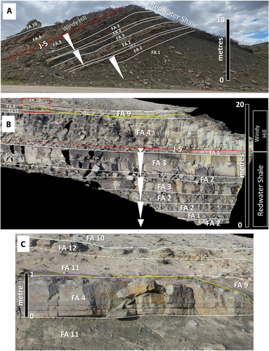
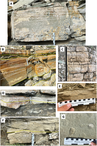
Facies Association 2 is composed of 2–30 cm thick coquinoid, bivalve shell hash beds (facies B) with scoured or sharp horizontal bases. Facies Association 2 is found exclusively in the Redwater Shale and is best represented at Seminoe Reservoir, where it forms resistant ridges in the lower 3–6 m of the upper part of the Redwater Shale (Figures 5, 7 and 8C). At Alcova, FA 2 is present 6 m below the Windy Hill Sandstone and is truncated by HCS sandy beds (FA 3) present 1–1.5 m below the contact between the Redwater Shale and Windy Hill Sandstone (Figures 4 and 8F). Facies Association 2 is commonly interlaminated with FA1 and can occur as a single bed or as a stack of amalgamated beds that form a unit up to 1.5 m thick (Figure 8C).
4.1.4 Facies association 2: FA 2—interpretation
Similar accumulations of bivalve-dominated shell hash have been described in Upper Jurassic deposits in France where thick, amalgamated beds of bivalve-dominated shell hash (FA 2) were interpreted as a product of a high degree of storm influence and reworking in a proximal offshore setting (Fürsich & Oschmann, 1986). The truncation of FA 2 by HCS sand (FA 3) indicates decreased storm energy or possibly a more distal offshore setting than the amalgamated beds (Fürsich & Oschmann, 1986). It is thought that FA 2 accumulated in the offshore-transition to lower shoreface, where storm energy was high and sand delivery was limited. It is considered therefore that the Redwater Shale at Alcova represents a more distal, basinward setting compared to Seminoe, which lies 47 km to the south, although the precise chronostratigraphic correlation is not confidently known.
4.1.5 Facies association 3: FA 3—description
Facies Association 3 consists of HCS and SCS, very fine-grained sandstone and ripple laminated sandstone beds that are interspersed with structureless to laminated, glauconitic siltstone and sandstone. Most HCS and SCS beds are sharply capped by FA 1 or additional beds of FA 3, locally, symmetrical ripples are preserved at their bedtops (facies D). Facies Association 3 is found at all three localities although it is best expressed at Seminoe Reservoir (Figures 5, 7 and 8A,B,D). Facies Association 3 can occur by itself or interlaminated with FA 2. Chondrites, Cosmoraphe, Nereites, robust Rhizocorallium and Thalassinoides are among the ichnofossils found on the upper surfaces of the HCS and SCS beds of FA 4 and comprise a classic Cruziana Ichnofacies (Bromley, 1996; Ekdale et al., 1984; Gingras et al., 2008; Knaust, 2017; MacEachern & Bann, 2008).
4.1.6 Facies association 3: FA 3—interpretation
The increasing amount of sand upward in the section at Seminoe and Alcova is characteristic of shoaling-upward profiles along storm wave-dominated, open marine coastlines (Plint, 1988; Hampson, 2000). The HCS and SCS are typically considered the product of storm wave orbitals interacting with the sea floor (Dott & Bourgeois, 1982; Dumas & Arnott, 2006), and their presence within the Redwater Shale is consistent with previous interpretations of the unit as being dominated by storm wave deposits (Brenner et al., 1985; Brenner & Davies, 1973, 1974; Danise & Holland, 2017, 2018; Holland & Wright, 2020).
Sedimentary structures by themselves are only generally linked to water depth in wave dominated coastlines. For example, storm wave-base in Florida was measured at 50 m on the Gulf of Mexico side yet reaches 100 m on the Atlantic side. This difference reflects the effect of a semi-enclosed versus open ocean basin (Peters & Loss, 2012). The HCS and SCS formed at shallow water depths have a much lower chance of preservation due to the high probability of reworking by subsequent fairweather wave or tidal action and the trace making activity of benthic organisms (Peters & Loss, 2012). Examples of HCS in the shoreface and tidal zones have been found in the modern stratigraphic record including on modern open-coast tidal flats (OCTF; Budillon et al., 2006; Keen et al., 2006; Yang et al., 2006), but the probability of preserving these discrete oscillatory-combined flow events in shallow water settings in the rock record is considered low (Peters & Loss, 2012). The formation and preservation of sedimentary structures in deeper water environments (i.e. the distal lower shoreface to offshore) is closely linked to the across-shelf transport of sediment, which preferentially occurs during the oscillatory-combined flow conditions characteristic of storm waves and relaxing storm surges (Peters & Loss, 2012). It is possible for sediment transported to lower shoreface and offshore-transition areas during storms to be reworked into normal wave ripples and dunes by large fairweather waves formed by distantly generated storm swell (Peters & Loss, 2012). However, the probability of fairweather wave interaction with storm-delivered sediment is sufficiently low in offshore settings that it is more common for offshore-exported sediment to remain as discrete, HCS-dominated event beds and be preserved as such in the stratigraphic record (Peters & Loss, 2012). The presence of current ripples at the tops of some FA 3 beds at Seminoe demonstrates that some fairweather waves modified storm-delivered sand in this system, as would be expected in a more proximal, lower shoreface setting. The presence of FA 3 in the Redwater Shale can be most parsimoniously interpreted as storm-delivered sand that remained unmodified in the offshore environment but was modified and partially reworked through the action of fairweather waves in an offshore-transition to lower shoreface setting.
The ichnofossil evidence for a generally open marine, minimally stressed environment, punctuated by high sedimentation events matches the lithological indicators suggestive of episodic storm wave delivery and modification of sand and shell material (see Fürsich & Oschmann, 1986; Pemberton et al., 2012; Pemberton & Frey, 1984).
4.1.7 Facies association 4: FA 4—description
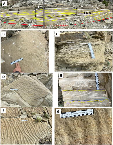
Facies Association 4 occurs in the Windy Hill Sandstone at all three locations and is absent from the underlying Redwater Shale. It consists of horizontally bedded sets of parallel and ripple-laminated to small-scale cross-bedded, quartz-rich sandstone that has little or no carbonate cement (Figure 9 B,D through G). Silty partitions are present between the sand-prone beds, and these can contain Palaeophycus and Sinusichnus, however, invertebrate traces are otherwise uncommon in FA 4 except for rare Protovirgularia and Cochlichnus. Ripple cross-sections are symmetrical or slightly asymmetrical and interference ripples are common at Seminoe and Glendo. Facies Association 4 exhibits an irregular, somewhat braided, textured surface at the Seminoe outcrops (Figure 9G) and abundant pterosaur tracks (Pteraichnus) occur along with uncommon Cochlichnus.
4.1.8 Facies association 4: FA 4—interpretation
The braided textured surface at Seminoe together with the excellent preservation of small footprints like Pteraichnus is indicative of development of microbial mats (see de Souza Carvalho et al., 2013; Lockley et al., 2022). Microbial mats or biofilm are bacterial colonies that thrive at chemical gradients such as those experienced on intertidal flats and can survive for several hours in subaerial conditions during low tide (Briggs, 2003). The presence of marine invertebrate traces alongside evidence for multidirectional current flow, subaerial exposure and potential microbial mat development is consistent with previous interpretations of the Windy Hill Sandstone as a shallow, subtidal to intertidal flat at Seminoe and Alcova (Connely, 2006; Meyers & Breithaupt, 2014).
Identical sedimentary structures can be found on the modern intertidal flats of the Trinity bayhead delta on the south-eastern Texas coast where they record the interaction of fluvial and tidal currents on very fine-grained, sandy mouth bars (Wroblewski & Steel, 2022). Flashy discharge within ephemeral streams can also produce interference ripples (Picard & High, 1970), however, the Windy Hill deposits are not contained within channels and are not associated with sedimentary features that are characteristic of fluvial bars and beds. Instead, these deposits are probably the result of flat washout surfaces between patches of ripple crests that form shortly before subaerial emergence during low tide, resembling features on modern back-barrier tidal flats (Klein, 1971 Flemming, 2012, figure 10.17j) and suggest an intertidal origin for at least some of FA 4 (Figure 9B).
4.1.9 Facies association 5: FA 5—description
Facies Association 5 is characterised as a heterolithic succession of siltstone and sandstone beds with parallel, wavy and ripple lamination forming a 5.5–6 m thick succession at Alcova Reservoir (Cottonwood Creek), where it may represent the expression of the informal Lake Como Member of the Morrison Formation (Connely, 2006). Holland and Wright (2020) included a 7 m interval that includes this facies association in the Windy Hill Sandstone at this location. They recognised a 2–2.5 m thick sand body consisting of FA 4 and FA 7 at the base of the Windy Hill Sandstone, which provides a point of comparison between their measured section and the one presented herein as part of this study (Figure 4). Overall, FA 5 has a weathered expression with poor exposure of bedding surfaces which contrasts with the better cemented FA 4. Overall there is a paucity of vertebrate and invertebrate traces within FA 5.
4.1.10 Facies association 5: FA 5—interpretation
At Alcova, FA 5 overlies a basal succession of FA 8 and FA 4, where it is considered representative of a compound tidal dune to intertidal flat succession; at Seminoe, it overlies the sandy intertidal flats of FA 4 (Figure 5). This consistent stratigraphic context matches the depositional models of Klein (1971) wherein low tide areas of tidal flats are dominated by sand with ripple lamination and cross bedding, whereas mid-flat regions feature interbedded, heterolithic silt, clay and sand. The lack of evidence for intertidal exposure such as washouts, Pteraichnus and dinosaur tracks in FA5 could be a result of poor exposure of bedding planes. Alternatively, the lack of invertebrate ichnofossils in FA 5 could be indicative of extreme salinity, temperature and oxygen stress, consistent with restricted marine circulation in a back-barrier environment (Buskey et al., 1998) and prolonged exposure of a mid-flat area during low tide. Together with the linked FA 4, the succession of sandy, low tide flat deposits to heterolithic and silty, mid-flat deposits indicate a tidal range of approximately 3.5 m at Alcova (Figure 4) and 2–3 m at Seminoe (Figure 5).
4.1.11 Facies association 6: FA 6—description
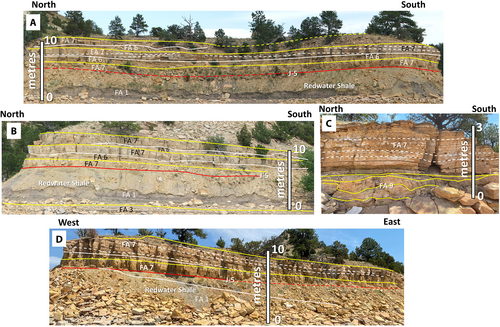
Facies Association 6 is a sandy heterolithic deposit composed of very fine-grained sandstone interlaminated with silt-prone sandstone in centimetre-scale beds. Facies Association 6 has only been recognised in the Windy Hill Sandstone at Glendo Reservoir. Internally sandstone and siltstone beds are a mix of planar laminated to structureless, although ripples are present locally on the sandstone bedtops. Facies Association 6 is typically found underlying the relatively cleaner, ripple-laminated FA 7 and grades laterally and vertically into it (Figure 10).
4.1.12 Facies association 6: FA 6—interpretation
The association of FA 6 and FA 7 and the gradational contact between them, both laterally and vertically, forms a basis for recognising them as genetic packages of coarsening-upward and cleaning-upward sand that are distinctive at outcrop. This relationship indicates a continuity of depositional processes associated with variations in transport energy and current speed. The heterolithic nature of this facies association suggests episodic sedimentation possibly associated with tidal influence and deposition on a mouth bar fringe (Tye & Hickey, 2001; van Yperen et al., 2020). Tidal mouth bar fringes in low accommodation settings lack the higher angle accretion sets seen in cleaner, more axial or upper parts of the bars (van Yperen et al., 2020) and have facies that are consistent with those observed within FA 6.
4.1.13 Facies association 7: FA 7—description
Facies Association 7 is similar to FA 3 but the rippled beds are organised into low angle, 1 to 3.5 m tall accretion sets that build obliquely or perpendicular to palaeoflow, as indicated by ripple crests (Figure 10). Fragments of invertebrate shells are present on the accretion set surfaces and between ripple crests. Some uncommon surface traces include Protovirgularia, which is interpreted to be the locomotion trace of a bivalve (Carmona et al., 2010). Facies Association 7 also has the same irregular surface that is observed on FA 4. Locally, FA 7 is bound by an underlying sharp-based surface that is either planar or shallowly scoured, which lacks rip-up clasts, pebbles, shells or any other feature that is characteristic of a lag deposit that is typical of fluvial and tidal channels (Figure 10A,B). At other locations, along the same stratigraphic interval, FA 7 grades laterally into the heterolithic, siltstone and very-fine-grained sandstone of FA 6. Bedding is extremely regular and appears rhythmic.
Invertebrate ichnofossils are rare in FA 7 but when present, they are dominated by large Conichnus. Smaller Palaeophycus and Sinusichnus are preserved in some of the silty parting lineation between accretion sets. Dinosaur tracks left by small and large theropods and sauropods are present on the upper surfaces of FA 7 as are isolated pterosaur tracks.
4.1.14 Facies association 7: FA 7—interpretation
Some of the large Conichnus traces show evidence of upward adjustment following episodes of sediment accumulation. The presence of small Palaeophycus and Sinusichnus suggest there was opportunistic colonisation of the substrate during periods of low ambient energy and less turbulence (see Olariu et al., 2012). The preservation of the dinosaur and pterosaur tracks indicate very shallow water or even subaerial exposure of these bars during low tide.
Facies Association 7 is interpreted to represent the upper part of subtidal to intertidal mouth bars due to its incision by and lateral relationship with distributary channel deposits. Bars, in contrast to dunes, have crests aligned parallel to flow and internal crossbedding, composed of dunes, ripples and laminated sediment, organised into laterally accreting sets (Dalrymple et al., 2012; Olariu et al., 2012). In addition, the rhythmic bedding observed within the heterolithic facies of FA 7 is reminiscent of modern examples of tidal rhythmites from the tide influenced portions of meandering rivers (Dalrymple et al., 2012, figure 5.19). Similar to the related FA 6, this facies association occurs in the Windy Hill Sandstone at Glendo but is absent at Alcova and Seminoe.
4.1.15 Facies association 8: FA 8—description
Facies Association 8 occurs exclusively in the basal Windy Hill Sandstone at Alcova (Figures 4 and 9A,C). The lower surface of FA 8 is sharp and planar or is a very shallow scour that intersects the heterolithic, siltstone and sandstone of FA 1 in the Redwater Shale. Low-angle foresets within FA 8 are stacked vertically and downslope of each other, creating compound bedsets that are separated by discrete, combined erosional and depositional surfaces. Foresets can be clean or siltstone and claystone-draped, they are typically unidirectional, although examples of bidirectional bedding is preserved locally towards the top of FA 8 (Figure 9C). Ichnofossils are absent from FA 8, although thin, centimetre-scale caps of rippled sand, bearing Pteraichnus accumulated directly upon FA 8.
4.1.16 Facies association 8: FA 8—interpretation
Facies Association 8 is interpreted as simple and compound tidal dunes. The lack of three-dimensional exposure of FA 8 makes it impossible to ascertain the orientation of the bed boundaries perpendicular to flow direction, however, the depositional architecture closely resembles compound dunes described in subtidal to intertidal settings (see Dalrymple et al., 2012; Olariu et al., 2012). Dunes are identified as having crests perpendicular to current flow and cross bedding organised into forward accreting sets, unlike bars (Allen, 1980; Dalrymple, 1984; Dalrymple et al., 2012; Dalrymple & Rhodes, 1995; Olariu et al., 2012). Compound tidal dunes are formed by the stacking of simple tidal dunes into amalgamated sand bodies and in the stratigraphic record were previously interpreted as tidal sandwaves (Allen, 1980; Allen & Homewood, 1984; Dalrymple, 1984; Kreisa et al., 1986; Nio, 1976).
Based on measured migration rates of bedforms in modern environments (cf. Dalrymple & Rhodes, 1995), individual dune sets would have formed in days to weeks, with up to 1 m of migration during a single tidal cycle, whereas large (5–10 m tall and 20–30 m long) compound dunes like those in the Lower Eocene Ager Basin, Spain developed in years to decades (Dalrymple et al., 2012; Olariu et al., 2012). The 75 cm tall, 10–20 m long compound dunes at Alcova probably formed in months to years and in much shallower water than those in the Ager Basin. The ebb cap of the dunes is normally removed by flood tides, leaving an apparently unidirectional series of foresets (see Dalrymple et al., 2012) but at Alcova, parts of it are preserved, resulting in preservation of classic, “herring bone” stratification (Figure 9C).
Flow depth has been estimated from dune height in rivers using the formula flow depth = 6–10 x dune height (Bridge & Tye, 2000). Prediction of dune scaling from flow depth is extremely uncertain, however, and 90% of predictions are within a factor of 3.5 of observed dune dimensions (Bradley & Venditti, 2017). Data suggest that maximum dune height is ca 40% of flow depth but that such a relationship is rarely observed (Bradley & Venditti, 2017). The maximum height of foresets recorded in the compound dunes at Alcova is 50 cm, suggesting a flow depth of 3–5 m during maximum high tide. This compares well with the 3.5 m height of the subtidal mouth bars, indicating the minimum, maximum flow depth in the basal Windy Hill Sandstone at Glendo.
The lack of ichnofossils within FA8, indicates that conditions were not suitable for colonisation by marine or continental organisms, although the presence of Pteraichnus in the thin sandstone bed caps that accumulated directly upon FA 8 further support an interpretation of deposition in a shallow, tidal environment.
4.1.17 Facies association 9: FA 9—description
Contorted, heterolithic siltstone, claystone and sandstone contained within a discrete scour surface that crisply incised underlying deposits comprises FA 9. This facies association is present at Seminoe and Glendo but is absent at Alcova (Figures 9B,C and 10C). Sandy macroforms dominated by rippled, very fine-grained sandstone (FA 7) accumulated on top of FA 9 at Glendo, while at Seminoe, it is overlain by large-scale cross bedding in quartz-rich, poorly consolidated sandstone (FA 10). Facies Association 9 occurs 1.5–6 m above the base of the Windy Hill Member (depending on location) and followed accumulation of intertidal flats (FA 4) and subtidal bars (FA 7). Facies Association 9 commonly contains multiple generations of dinosaur tracks that created a trampled surface and destroying original bedding.
4.1.18 Facies association 9: FA 9—interpretation
Facies Association 9 indicates abandonment of distributary fluvial channels or tidal creeks and is recognisable by its grey-green to reddish-coloured, oxidised nature (Figure 10C). Sand is a significant component of the fill of these channels, suggesting abandonment due to avulsion rather than meander cut-off (Toonen et al., 2011). The channels may have been fluvial or tidally influenced distributary channels based on their contact with underlying tidal flat and tidal bar deposits and heterolithic fill (FA 4 and FA 7). The scours are laterally discontinuous and shallow, suggesting that the original channels were equally broad and shallow or that some degree of erosion has occurred prior to deposition of overlying sediment. Scoyenia is present but uncommon, suggesting moist substrate conditions at times (Bromley, 1996).
4.1.19 Facies association 10: FA 10—description
Facies Association 10 is only present in the basal part of the main body of the Morrison Formation at Seminoe. It consists of a > 10 m thick outcrop of moderately to poorly cemented, very fine-grained, quartz-rich sandstone with rounded sand grains that are arranged into centimetre to decimetre-thick foresets with high dip angle (20-35°). Locally the almost white sandstone has patches of orange and yellow.
4.1.20 Facies association 10: FA 10—interpretation
The combination of texture, sedimentary structures and grain size is consistent with aeolian dunes (Davies, 1997). This is further supported by the presence of thicker bundles of sandstone at the base of foresets suggesting grain flow resulting from avalanching on subaerial dunes. In addition, the patchy colouration of the sandstone occurs below and within the toesets and lower parts of some of the foresets, which suggests there was subaerial exposure prior to, during, and after accumulation of FA 10.
Aeolian deposits are known from the Morrison Formation on the Colorado Plateau (Hasiotis, 2004) and are consistent with a dry, semi-arid coastal climate. Facies Association 10 is gradational with FA 8 and FA 9, suggesting interaction between onshore, coastal dunes and tidally influenced distributary or fluvial channels. This contrasts with the deposits at Glendo and Alcova, where intertidal and subtidal deposits of the Windy Hill Sandstone are capped by fluvial channel belt deposits and carbonaceous to clay-rich, overbank deposits of the main body of the Morrison Formation.
4.1.21 Facies association 11: FA 11—description
Facies Association 11 is a structureless, dark greenish-grey, silt-prone sandstone with minor amounts of clay. It is present in the main body of the Morrison Formation at Alcova and Glendo reservoirs. It is generally structureless, but laminations and contorted bedding are present in some intervals. Concretionary carbonate nodules are present in some intervals also.
4.1.22 Facies association 11: FA 11—interpretation
Facies Association 11 is interpreted to represent fluvial overbank deposition in a coastal or alluvial floodplain setting and possibly coastal lagoons (Connely, 2006). The contorted to structureless appearance is probably a result of bioturbation by roots, burrowing invertebrates and trampling.
4.1.23 Facies association 12: FA 12—description
Facies Association 12 constitutes iron oxide-stained and nodular rip-up clasts of siltstone and fine-grained sandstone within massive to contorted sandstone and siltstone units. Facies Association 12 is contained within broad, shallow, scoured surfaces that can be traced laterally for tens of metres.
4.1.24 Facies association 12: FA 12—interpretation
Facies Association 12 is the result of chemical weathering of other facies associations and is composed of oxidised claystone, siltstone and sandstone. Facies Association 12 results from subaerial exposure and is present at the top of the basal 2–3 m of the Windy Hill Sandstone at Glendo Reservoir and 6 m above the base at Seminoe Reservoir (Figure 5). Subaerial exposure is inferred due to the presence of oxidised siltstone beds, abundant bioturbation, including dinosaur tracks and Scoyenia gracilis. At Seminoe, the lower, scoured surfaces containing the pedogenically modified deposits can be walked out laterally for 24 m where it grades laterally from an abandoned channel fill to aeolian bedforms (Figure 9). At Glendo, subaerial exposure surfaces are evident in abandoned channel deposits with large sauropod dinosaur tracks and contorted, sandy to clay-rich bedding.
4.2 Ichnology
Ichnofossils in the Redwater Shale Member are most easily observed in outcrop sections that are well lithified and resistant to erosion. In the Windy Hill Sandstone, overall, invertebrate ichnofossils are less abundant compared to the Redwater Shale, although large, simple vertical burrows are common within the Windy Hill Sandstone at Glendo while small, simple, horizontal burrows are more common in the succession at Alcova and Seminoe. Dinosaur and pterosaur tracks are abundantly preserved at all three locations (Connely, 2006; Logue, 1977; Meyers & Breithaupt, 2014) within the Windy Hill Sandstone and provide important information on water depth at the time of accumulation. Four ichnofacies or ichnoassociations have been recognised: an offshore to offshore-transition assemblage (Cruziana Ichnofacies), nearshore (tidal bar and lagoon) assemblage (Skolithos Ichnofacies), onshore tidal flat assemblage (Pteraichnus Ichnofacies), and marginal lake or abandoned channel-fill assemblage (Scoyenia Ichnofacies) (Table 3).
| Depositional environment | Ichnofacies | Facies associations | Sedimentary structures | Ichnofossils | Member |
|---|---|---|---|---|---|
| Aeolian dunes and interdunes | Scoyenia | FA 10 | Planar and trough cross-bedding | Dinosaur tracks | Windy Hill?, main body Morrison |
| Abandoned Channel Belt | Scoyenia | FA 9, FA 11, FA 12 | Structureless, contorted, ripples, cross-bedding | Dinosaur tracks, Scoyenia | Windy Hill |
| Intertidal Bar | Skolithos | FA6, FA7 | Asymmetrical ripples, planar lamination | Conichnus, Palaeophycus, Protovirgularia, dinosaur tracks | Windy Hill |
| Intertidal flat | Pteraichnus | FA4 | Interference ripples, symmetrical ripples, asymmetrical ripples, small crossbedding, planar lamination |
Cochlichnus, dinosaur tracks, Pteraichnus, Sinusichnus |
Windy Hill |
| Mid-flat/lagoon | Stressed Skolithos | FA5, FA6 | TXS, ripples, wavy bedding, planar lamination | Skolithos, escape traces | Windy Hill |
| Offshore-transition-Lower Shoreface | Cruziana | FA 2, FA 3 | HCS, SCS, asymmetrical ripples | Chondrites, Cosmoraphe, Lockeia, Nereites, Palaeophycus, Phoebichnus, Rhizocorallium, Rosselia, Spongeliomorpha, Taenidium, Thalassinoides | Redwater Shale |
| Offshore | stressed Cruziana | FA1 | Structureless to laminated | Chondrites, general bioturbation | Redwater Shale |
4.2.1 Offshore to offshore-transition assemblage—Cruziana Ichnofacies
At Glendo and Seminoe, the most visible and recognisable ichnofossils in the Redwater Shale Member are the large (2–3 cm diameter) tubes and spreite of Rhizocorallium commune var. irregulare found in FA 3 (Figure 11B,H,I). Complete churning and bioturbation of the upper surfaces of very fine-grained, sandstone storm beds by R. commune var. irregulare is common on many of the surfaces visible in the upper part of the Redwater Shale at Seminoe and the lower sections at Glendo (Figures 5 and 6). Cosmoraphe are also present on rippled surfaces of glauconitic sandstone beds (Figure 11E). Some specimens preserve scratch marks along their lower surfaces (Figure 11B) and faecal pellets are abundant around apertures at the surfaces of storm beds at Seminoe (Figure 11H). Rhizocorallium commune var. irregulare is commonly observed in a broad range of marine settings, including deepwater, shelf, nearshore, back-barrier and estuarine environments (Farrow, 1966; Knaust, 2013; Rodríguez-Tovar & Pérez-Valera, 2008; Worsley & Mørk, 2001) and it is a member of the Cruziana Ichnofacies. In general, specimens observed in stressed environments such as estuaries, lagoons and bays are typically smaller than those found in open marine settings (see Pemberton & Wightman, 1992), this would suggest that those preserved within the Redwater Shale are representative of fully marine, open coast environments with minimal physicochemical stress and optimal conditions.
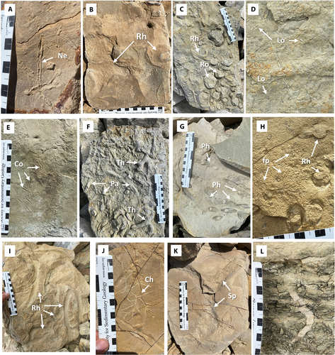
Thalassinoides suevicus is another ichnotaxon commonly observed within the Redwater Shale at all three localities in the study area. It is most abundantly preserved on the underside of well-cemented, very fine-grained sandstone beds of FA 1 that overlie poorly cemented siltstone or very fine-grained, glauconitic sandstone beds (Figure 11F). Similar to R. commune, T. suevicus is found in a wide variety of marine environments ranging from deepwater to shallow marine, to brackish water estuaries (Knaust, 2017; Monaco et al., 2009; Nickell & Atkinson, 1995; Swinbanks & Luterbauer, 1987). It is most commonly attributed to thalassinidean shrimp and polychaetes, although a variety of other taxa have also been implicated in the construction of T. suevicus (Knaust, 2017). In the Sundance Formation, body fossils of mecochirid lobsters and lobster-like glyphyids have been collected (Herrick, 1977), both of which are possible candidates as the excavators of T. suevicus and other, large-diameter, horizontal, branching burrows within the RS, such as Spongeliomorpha. Thalassinoides is a common constituent of the firmground Cruziana Ichnofacies (Knaust, 2017).
Spongeliomorpha is architecturally similar to Thalassinoides, with the exception of an irregular, scratched surface resulting from construction in a firmground substrate (Ekdale et al., 1984; Schlirf, 2000). Apertures are preserved in some specimens in FA 3 at Glendo Reservoir; they are characterised by a broadening of the tunnel diameter with a radial pattern of scratch marks fanning outward, and their apex at the aperture. Examples of this architecture are abundant in very fine-grained, sand-prone storm beds (FA3) of the Redwater Shale at Seminoe Reservoir, their occurrence in association with the abundant glauconite, are considered proxies for relatively low rates of sediment accumulation (Hesse & Schacht, 2011; Velde, 2014) and compaction-induced dewatering (Figure 11K).
Chondrites intricatus is common on the upper surfaces of FA 3 of the Redwater Shale at Glendo and Seminoe (Figure 11J). The characteristic, dendritic pattern of equal-diameter burrows with no lining and an active fill makes for easy recognition of this ichnotaxon (see Fu, 1991). Chondrites is generally constructed in fine-grained softgrounds (Knaust, 2017) and its preservation at the tops of storm beds in the Redwater Shale resulted from the excavation of an overlying, softground substrate prior to contact with the underlying, firmground storm deposit. Chondrites is a well-documented proxy for dysoxic settings with dissolved oxygen content between 0.2 mL/L and 1.0 mL/L in bottom and pore waters (Bromley & Ekdale, 1984; Martin, 2004; Savrda & Bottjer, 1991). Its presence in the glauconitic beds of the offshore to distal lower shoreface of the Redwater Shale supports an interpretation of accumulation in an oxygen-poor, offshore setting below the influence of most storm and fairweather waves.
A less common ichnotaxon in the Redwater Shale is Rosselia socialis (Figure 11C). The diagnostic, mud-filled apical bulb, lined with concentric laminae that reaches up to 5 cm in diameter occurs in concentrations at the upper surfaces of FA 3 at Seminoe Reservoir. Rosselia socialis has been interpreted as the dwelling structure of terebellid polychaetes (Nara, 1995, 2002) and is common in a variety of fully marine to brackish water environments (Carmona et al., 2008; Uchman & Krenmayr, 1995). It is a common component of the Cruziana Ichnofacies and is associated with high sedimentation rates and repeated erosion (Campbell et al., 2006, 2016; Frieling, 2007; Nara, 1995, 2002; Netto et al., 2014). It is most abundant in transgressive settings (Nara, 2002).
Nereites isp. is present locally on bed surfaces of FA 3 at Glendo and Seminoe reservoirs, characterised by a meandering, horizontal burrow with an actively filled central core and a thick, lobed mantle (Figures 5, 6 and 11A). The maker of Nereites is unknown, but it is interpreted as a grazing trace, possibly by an enteropneust (Mángano et al., 2000). Nereites is common in quiet water, deep marine settings but is also a component of the Cruziana Ichnofacies as a shallow tiered ichnotaxon (Knaust, 2017; Wetzel, 2002).
Phoebichnus trochoides is present in FA 3 in the upper part of the Redwater Shale Member at Seminoe Reservoir (Figure 11G). It is distinctive with radiating, horizontal burrows with a discrete annulated wall and an active fill, meniscate back-filling; individual burrows are 1 cm in diameter (see Bromley & Asgaard, 1972; Evans & McIlroy, 2016). Although the tracemaker remains unidentified, P. trochoides has been interpreted as the feeding trace of a sessile, deposit-feeding animal (Bromley & Asgaard, 1972). It is common in shelf, shoreface and delta front deposits where it is indicative of a low-energy depositional setting, with limited sediment accumulation, and an abundance of nutrients in the sediment (Bromley & Mørk, 2000; Dam, 1990; Heinberg & Birkelund, 1984; Joseph et al., 2012; MacEachern & Bann, 2008; Martin & Pollard, 1996; McIlroy, 2004; Morris et al., 2006; Pemberton et al., 2012; Pemberton & Frey, 1984). Phoebichnus is a member of the Cruziana Ichnofacies and is common in the Mesozoic (Evans & McIlroy, 2016).
Lockeia siliquaria is present in both FA 1 and FA 3 of the Redwater Shale as abundant almond-shaped specimens, 0.7–1.0 cm long, that have faint, smooth, hypichnial ridges (Figure 11D) (see Schlirf et al., 2001). Lockeia siliquaria has been interpreted as either the imprint of the foot or the shell of a resting bivalve (Osgood, 1970; Seilacher, 1953; Seilacher & Seilacher, 1994). A diversity of bivalve shells, including the ubiquitous Camptonectes is also preserved in the Redwater Shale and they are found in abundance in the rubble on the shores of all three study sites. Lockeia siliquaria is a component of the firmground Cruziana Ichnofacies and occurs in a broad spectrum of shallow to deep marine environments (Paranjape et al., 2013).
Taenidium serpentinum is infrequently found on surfaces of FA 3 at Seminoe Reservoir (Figure 11L). Characterised by thick, regularly spaced backfills that are smaller than the burrow diameter, and with no lining or mantle, these traces record a combination of detritus-feeding, locomotion and dwelling by arthropods or polychaete worms (Knaust, 2017). Taenidium has been documented in a variety of continental and marine environments where it is a component of the Scoyenia and Cruziana Ichnofacies respectively (Knaust, 2017; Savrda et al., 2000).
Finally, Palaeophycus heberti is present in most of the offshore and nearshore to onshore deposits (FA 1, FA 3, FA 4, FA 5, FA 6 and FA 7) of the Redwater Shale at all three locations (Figure 11F). It is similar to Thalassinoides but has a sharp burrow lining and lacks the enlarged, T-shaped and Y-shaped junctions typical of Thalassinoides. It is interpreted to be the dwelling structure of a predator or suspension-feeding polychaete. Palaeophycus is common in marine and continental depositional environments and is a constituent of several ichnofacies (Dashtgard & Gingras, 2012; Gingras et al., 2012; Knaust, 2017).
4.2.2 Nearshore (tidal Bar and lagoon) assemblage—Skolithos Ichnofacies
Conichnus conicus is common in the rippled, very fine-grained sandstone (FA 7) of the Windy Hill Sandstone at Glendo and within FA 6 at Alcova (Hasiotis, 2004) but has not been observed at Seminoe (Figure 12A,B,D,E). In specimens observed at Glendo, the characteristic, downward-deflected laminae surrounding a massive, actively reworked burrow are clearly visible, these result from the vertical movement of the burrower. Periodic upward adjustment in response to episodic sediment accumulation resulted in the development of an equilibrium trace with a stacked appearance in some specimens (Figure 12A,B). Conichnus conicus has been interpreted as the dwelling trace of sea anemones and bivalves (Bromley, 1996; Frey & Howard, 1981; Gingras et al., 2008; Schäfer, 1962; Shinn, 1968). Conichnus is a component of the Skolithos Ichnofacies and is commonly found in high energy environments with high sedimentation rates such as shorefaces, flood-tidal deltas, estuaries and tidal flats (Abad et al., 2006; Curran & Frey, 1977; Mata et al., 2012; Savrda, 2002; Shinn, 1968). Its presence in FA 7, which is interpreted as the deposits of subtidal mouth bars, is therefore consistent with its known palaeoenvironmental preferences.
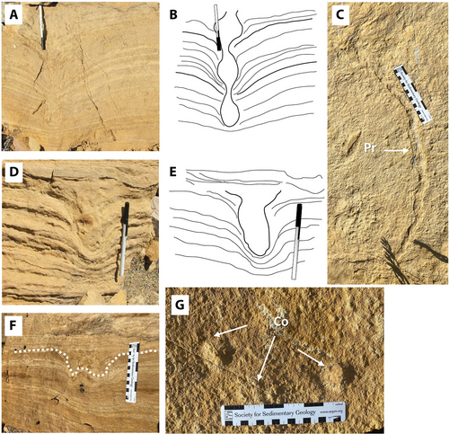
Protovirgularia is interpreted as the locomotion trace of a bivalve moving across the sediment surface (Carmona et al., 2010). It is found on the surface of FA 7 within the Windy Hill Sandstone at Glendo (Figure 12C). The characteristic, delicate, inclined to horizontal chevron structures of this ichnogenus are not clearly visible in the specimens; however, this is p a function of their preservation within a tidally influenced sand that was prone to wipe out such delicate structures, partially obliterating the millimetre-scale ridges and grooves on the surface trace as a result of modification by tidal currents and shifting sediment. Able to tolerate tidally induced fluctuations in salinity, sedimentation rates, turbidity and oxygen depletion, the makers of Protovirgularia were opportunistic inhabitants of nearshore environments (Carmona et al., 2010). The same bivalves that made Protovirgularia may have also constructed some of the Conichnus specimens present in the tidal bars at Glendo.
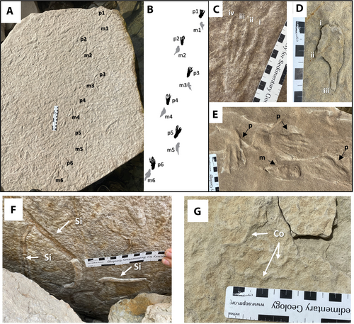
Sinusichnus seilacheri is also present although it is uncommon in the silty sandstone laminae of FA 6 and FA 7 at Glendo and Seminoe (Figure 13F). At Glendo, it is preserved on the surfaces of sandy beds within tidal bars of the basal Windy Hill Sandstone. At Seminoe Reservoir, pterosaur tracks (Pteraichnus saltwashensis) (Figure 13A through E) are present alongside Sinusichnus, indicating a shallow subtidal to intertidal setting for at least some of the burrows. Sinusichnus is interpreted to result from the combined dwelling, locomotion and feeding activity of decapod and isopod crustaceans. This trace was previously only known from the Ordovician of North America, although it has been reported elsewhere in Mesozoic and Cenozoic- strata (Buatois et al., 2009; Knaust & Desrochers, 2020; Soares et al., 2020;).
4.2.3 Onshore tidal flat assemblage—Pteraichnus Ichnofacies
In addition to the classic, Seilacherian ichnofacies (cf. MacEachern et al., 2012), a Pteraichnus Ichnofacies was proposed to accommodate a specific, fine-grained, marine tidal flat depositional setting (Lockley et al., 2001; Lockley & Meyer, 2000; Lockley & Wright, 2003). The Pteraichnus Ichnofacies records a distinctive ethological response to the environment (locomotion and feeding) and is constrained to shallow, intertidal to lacustrine shorelines, thus adhering to the criteria for recognising ichnofacies (MacEachern et al., 2012), despite being limited to the Mesozoic. Recent additions to the global record of pterosaur tracks and trackways have proven the utility of the Pteraichnus Ichnofacies as an indicator of shallow water and intertidal environments beyond the Upper Jurassic of the North American Western Interior (Elgh et al., 2019; Li et al., 2021; Masrour et al., 2018; Mazin et al., 1995, 2009). In the context of the Oxfordian of the North American Western Interior, the Pteraichnus Ichnofacies is useful as a means of separating the intertidal, marine deposits of the basal Windy Hill Sandstone from the continental, fluvial and lacustrine deposits of the main body of the Morrison Formation and the underlying, open marine deposits of the Redwater Shale. It also helps establish minimum water depth in rippled, heterolithic sandstone deposits that would otherwise be difficult to assign to a particular flow height.
Pteraichnus saltwashensis was previously reported from FA 4 of the Windy Hill Sandstone at Alcova, Glendo, Seminoe and other locations but with limited stratigraphic context (Connely, 2006; Hasiotis, 2004; Logue, 1977; Meyers & Breithaupt, 2014). At Seminoe, P. saltwashensis is represented in FA 4 in at least three stratigraphic intervals within the lower 4 m of the Windy Hill Sandstone; the lowest occurrence being just 70 cm above the contact with the underlying Redwater Shale (Figure 5). Locally, sections of the trackways are manus dominated, and some are pes dominated, while others record a normal walking pace (Figure 13A,B). A manus-dominated trackway at Glendo occurs at the top of the Windy Hill Sandstone and is capped by weathered claystone and siltstone, indicating accumulation in a lagoon or pond. Manus prints are 5.5–10 cm long and exhibit three laterally to caudally splayed fingers with no claw impressions, suggesting the unguals were held in a retracted position (see Frey et al., 2003) possibly as the pterosaurs punted along the bottom while buoying up their bodies. Pes tracks are typically 8–11 cm long with an average of 9 cm, these correspond to a wingspan of approximately 1.5–1.8 m, based on comparisons to the basal pterodactyloids Pterodactylus antiquus (specimen BSP AS I 739) and Germanodactylus cristatus (specimen SMNK PAL 6592). They exhibit four toes with digital pads, claws and possible webbing. A circular heel pad is the deepest part of some prints as reported in other such examples from the Upper Jurassic of Crayssac, France and Asturia, Spain (Frey et al., 2003; Mazin et al., 1995). The medial and lateral metatarsal form deeper impressions than the central two metatarsals, which indicates a slight longitudinal arch similar to the specimens from France and Spain, but different from the type specimens from Arizona, USA described by Stokes (1957).
Cochlichnus is found on bedding planes of rippled to parallel-laminated, very fine-grained sandstone (FA 4) that are interpreted to represent intertidal flats in the Windy Hill Sandstone at Seminoe (Figure 13G). This sinuous surface trail resembles a sine wave and has been interpreted to represent the locomotion trail of aquatic annelids moving when the water table is at or near the sediment-water-air interface (Buatois & Mángano, 1993; Crimes, 1992; Fillion & Pickerill, 1990). Its presence supports interpretations based on sedimentary structures and tetrapod track for shallow subtidal to intertidal exposure of the deposits at Seminoe.
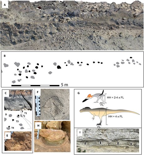
Dinosaur tracks are common in FA 7, FA 9, FA 10, FA 11 and FA 12 of Windy Hill Sandstone and they are present at all three outcrop localities (Figure 14). Sauropod tracks are preserved in the mixed aeolian-tidally influenced fluvial bedforms (FA 8 and FA 10), 6 m above the base of the Windy Hill Sandstone at Seminoe (Figure 14F,I). At Glendo, dinosaur tracks are preserved in rippled, fine-grained sandy beds representing FA 7 (Figure 14C,D). Characteristics of the tracks such as indistinct morphology, extremely deformed beds below them, and their depositional context indicate they were made by animals walking on a saturated or partially submerged substrate (Bennett et al., 2014; Wroblewski & Gulas-Wroblewski, 2021). Presence of dinosaur tracks constrains the maximum water depth during low tide, as it would not be possible for the animals to leave deep foot impressions of a walking gait if the bulk of their weight was supported by water.
4.2.4 Marginal Lake or Abandoned Channel-fill assemblage—Scoyenia Ichnofacies
Dinosaur tracks and Scoyenia are the dominant ichnofossils in the heterolithic, abandoned channel-fill deposit (FA6) that marks the top of the Windy Hill Sandstone at Seminoe Reservoir (Figures 5 and 14A,B). Dinosaur tracks were also reported from channel deposits in the Windy Hill Sandstone by Hasiotis (2004); Table 1 although no location information was provided. Sauropod tracks have also been found in abandoned channel-fill deposits at Glendo along with poorly preserved Scoyenia (Figures 6 and 14H). With a distinctive, rope-like surface texture, the horizontal, curved, unbranched burrows of Scoyenia are recognisable where they have been diagenetically altered by iron oxide. Scoyenia is interpreted to be the dwelling and deposit feeding trace of a moisture-dependent insect-like beetle larvae and cicada nymphs (Bromley, 1996; Frey et al., 1984). The depositional context of Scoyenia and associated tracks in the Windy Hill Sandstone is consistent with accumulation in abandoned channel-fill deposits that retained a moist substrate for extended periods between the flood events that delivered sediment.
5 DISCUSSION
5.1 Ichnology and physicochemical conditions
Ichnofossil assemblages of the Redwater Shale supplement and bolster geochemical and palaeoecological data indicative of a less restricted connection to the proto-Pacific Ocean compared to earlier in the Jurassic (Danise et al., 2020; Imlay, 1980). Diverse assemblages of robust ichnofossils reflect optimal physicochemical conditions, which in offshore to lower shoreface settings include: abundant oxygen and nutrients, near-normal marine salinity (35 ppt) and minimal turbidity (Bromley, 1996; MacEachern & Bann, 2008; Savrda & Bottjer, 1991). The exception might be in the laminated, glauconitic sandstone beds of FA 1, which are relatively impoverished with regard to ichnofossil abundance, which is suggestive of oxygen deprivation.
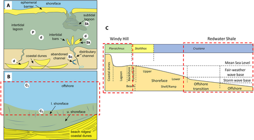
The ichnofossil assemblages of the Redwater Shale are typical of the Cruziana Ichnofacies and are consistent with sedimentary observations indicative of deposition in an offshore to offshore-transition environment (Figure 15). Both Nereites and Chondrites are characteristic ichnotaxa of low-energy marine environments with minimal sediment delivery and in the case of Chondrites, low oxygen content in bottom and pore waters (Bromley & Ekdale, 1984; Mángano et al., 2000; Martin, 2004; Savrda & Bottjer, 1991). The glauconitic nature of the sediment surrounding beds in which Chondrites and Nereites assemblages occur is typical of open marine, offshore environments with warm water, limited clastic input and oxygen deprivation (see Banerjee et al., 2020; Bansal et al., 2019; Hesse & Schacht, 2011; Velde, 2014). Both ichnotaxa are found in abundance at Glendo, while Chondrites is also common at Seminoe.
The shell coquina (FA 2) and sandstone-dominated (FA 3) storm beds in the Redwater Shale, indicate episodically high energy environments and increased sediment mobility. They are commonly heavily burrowed by Rhizocorallium and Thalassinoides, although only at their upper bed surfaces that are overlain by FA 1. Rosselia, Spongeliomorpha, Phoebichnus and Lockeia also contribute to the ichnotaxonomic diversity within the Redwater Shale at all three locations. The Redwater Shale outcrops at Seminoe exhibit the clearest signal of increasing sedimentation rates associated with shallowing shoreface profiles and greater fairweather wave influence, as the uppermost Redwater Shale contains FA 3 deposited in a lower shoreface setting (Figures 5, 7 and 8). Typically, the upper 10 cm of these storm beds and their upper bed surfaces are heavily bioturbated, reflecting descent of the burrowing organisms from a stratigraphically younger, higher sedimentary surface and resumption of fairweather conditions. The lower parts of the HCS beds of FA 3 contain few burrows, reflecting the rapid emplacement of thick accumulations of sediment during storms and preservation of the original depositional fabric, below the reach of the constituents of the Cruziana Ichnofacies (see Keen et al., 2012).
Tidal mouth bars (FA 7) of the Windy Hill Sandstone accumulated directly upon offshore shelf deposits of the Redwater Shale at Glendo Reservoir, with no evidence of shoreface or foreshore deposits preserved in the sedimentological or ichnological record. As expected in a high-energy, high-sediment accumulation setting with variable salinity gradients, such as sandy tidal bars, invertebrate ichnofossils are limited to large, vertical burrows (Conichnus) and simple, horizontal burrows (Protovirgularia and Sinusichnus) in sediment that accumulated during slack-water, colonisation windows. Invertebrate trace fossil abundance is low in these deposits, indicating a low number of trace-making organisms during sediment accumulation, which is consistent with a highly physicochemically stressed setting (Dashtgard & Gingras, 2012; Gingras et al., 2012). Dinosaur tracks of various size and Pteraichnus are also present on these tidal bars, demonstrating low-tide water levels that allowed terrestrial animals to traverse the deposits.
At Alcova and Seminoe, the Windy Hill Sandstone ichnofossil assemblages are consistent with accumulation in shallow, subtidal to intertidal environments, and they indicate a physicochemically stressed setting similar to Glendo. Overall, invertebrate trace fossils are uncommon in the Windy Hill Sandstone, which contrasts with the underlying Redwater Shale, where sedimentary structures are completely obliterated locally due to bioturbation. Sinusichnus is the most common invertebrate ichnofossil within the Windy Hill Sandstone at Seminoe, and it was probably made by isopods or decapods, both of which can tolerate a wide range of salinities, temperatures and water depths (Knaust & Desrochers, 2020). The abundant, well-preserved Pteraichnus are consistent with episodic sediment transport and the presence of a microbial mat, which created the perfect conditions for registration, early burial and preservation of the small tracks (Cuadrado et al., 2021). In comparable, present-day depositional settings, sedimentation rates between 0.32 cm/year and 0.41 cm/year have been recorded (Cuadrado et al., 2021), these rates suggest that the 5.5 m thick Windy Hill Sandstone succession at Seminoe could have accumulated in ca 1,341–1,719 years, while at Alcova, the 11.5 m succession may encompass 2,805–3,594 years. Such rapid accumulation of tidal flat deposits in a lagoon during a general shoreline retreat may indicate episodic pauses in sea-level fall and development of tidal back-barrier systems.
5.1.1 Tracks as low-tide depth indicators
Maximum water-depth during accumulation of tidal deposits is often difficult to estimate without a complete tidal flat succession or bar preserved (Klein, 1971), however, the presence of dinosaur tracks, such as the theropods tracks on the tops of 1–3.5 m tall tidal bars at Glendo that record 15 cm long feet indicating a hip height of 60 cm (see Henderson, 2003), provides a good proxy for low-tide water-depths. Based on this observation, these bar tops were either emergent or barely submerged under <30 cm of water during low-tide conditions as deeper water would have allowed the dinosaurs to be buoyed up so they could float or swim (Figure 14G).
While there is ichnological evidence that pterosaurs swam or were at least partially buoyed by water as they walked across submerged tidal flats (Lockley & Schumacher, 2014; Lockley & Wright, 2003), their swimming ability has been questioned based on digital models (Hone & Henderson, 2014). It seems most probable that the pterosaurs of the Windy Hill Sandstone were comfortable entering water shallow enough to wade and maintain at least some contact with the bottom, similar to modern wading shorebirds. Observations of Jurassic pterodactyloid pterosaur skeletons suggests that their standing hip height was approximately 2–4 times pes length (Figure 14G), which corresponds to an average hip height of 18 to 36 cm for the Windy Hill pterosaurs. The presence of Pteraichnus on sandstone beds that include washout ripples is evidence of subaerial exposure and tide-depths low enough to permit 18 cm tall pterosaurs to use a walking gait and leave clear tracks. Equivalent heterolithic mud-flat and clay-rich high-tide flat deposits (see Klein, 1971) represented by FA 5 at Alcova and Seminoe (Figures 4 and 5), suggest a tidal range of ca 3 m at Seminoe and possibly the same at Alcova, which would coincide with the 3.5 m height of the complete tidal bars preserved at Alcova.
5.2 Depositional environments
The contrast between the strongly tidal environments of the Windy Hill Sandstone and Upper Sundance Formation and the underlying, storm-dominated, open marine setting of the Redwater Shale Member has been recognised and debated for decades (Brenner & Davies, 1973, 1974; Danise & Holland, 2018; Holland & Wright, 2020; Johnson, 1992; Pipiringos & O'Sullivan, 1978; Uhlir et al., 1988). Based on the sedimentary and ichnological data from south-eastern Wyoming, the division between offshore to lower shoreface, storm wave-dominated Redwater Shale and coastal to onshore, tide-dominated Windy Hill Sandstone is reaffirmed. Rather than representing disparate endmembers, the Redwater Shale is directly linked to the Windy Hill Sandstone as part of a continuum of processes ranging from distal, storm-dominated to proximal, tide-dominated. Modern systems exhibiting this relationship such as the Texas coastline provide insight into the sedimentary and biological processes at play in the Jurassic and significantly, experience high-frequency changes in relative sea level due to external forcing mechanisms like glacioeustacy and compaction-induced subsidence.
A unifying model of open coast tidal flat (OCTF) and tidally modulated shorefaces (TMS) accounts for variability along the wave-tide continuum (Dashtgard et al., 2021) and its applicability to the Redwater Shale and Windy Hill Sandstone was tested. The key to identifying OCTFs and TMSs is that both should exhibit tidally modulated storm deposits and may also exhibit interbedding of tidally generated structures and storm deposits through the lower and possibly into the upper shoreface (Dashtgard et al., 2021). Tidally generated sedimentary structures were not recognised in the Redwater Shale of the study area and lower shoreface deposits are present at Seminoe, but lacking at Alcova and Glendo, where only offshore-transition deposits are present below the Windy Hill Sandstone. The model's failure to account for ichnological, sedimentological and stratigraphic observations in the study area suggests that it is not applicable to the Redwater Shale and Windy Hill Sandstone and that the continuum between storm and tidal deposition was interrupted.
5.2.1 Redwater Shale Member
The Redwater Shale at all three localities is largely composed of poorly exposed, glauconitic siltstone and very fine-grained sandstone. At Seminoe, the upper 9–12 m contain coquinoid beds and increasingly sand-rich beds that are dominated by HCS and SCS, that are locally amalgamated and arranged into parasequences (Figures 5 and 8). No such amalgamated beds are found at the same stratigraphic interval within the succession at Glendo, instead, HCS sandstone beds are found 7 m below the contact with the Windy Hill Sandstone (Figures 6 and 10). At Alcova, several closely spaced coquinoid beds (FA 2) are located 5 m below the contact with the Windy Hill Sandstone and just below it (Figure 4), but HCS and SCS sandstone beds (FA 3) are only observed within the uppermost part of the Redwater Shale (Figure 8E).
Storm-dominated, offshore to offshore-transition and lower shoreface deposits accumulate below fairweather wave base, typically between 15 and 100 m deep depending on basin physiography and other variables (see Keen et al., 2012). The presence of isolated beds of FA 2 and FA 3 that were sorted and reworked during storm events, but were not subsequently modified by fairweather waves or tidal currents, and were subjected to heavy burrowing activity that destroys the upper 10 cm of the original sedimentary structures, argues against their accumulation in water depths subject to fairweather wave activity (Dott & Bourgeois, 1982; Dumas & Arnott, 2006; Keen et al., 2012; Peters & Loss, 2012). Facies Association 2 and FA 3 deposits that experienced modification by fairweather waves accumulated in the lower shoreface and lack evidence of burrowing by soft-ground benthic invertebrates of the Cruziana Ichnofacies. Burrowed interbeds of glauconitic sandstone and siltstone between FA 3 and FA 2 deposits record fairweather colonisation by an ichnofauna typical of the offshore to offshore-transition (Cruziana Ichnofacies) and indicate an abundance of oxygen, nutrients and low turbidity associated with limited sediment accumulation rates (Knaust, 2017).
The glauconitic, structureless to planar laminated siltstone and sandstones that are infrequently burrowed by Chondrites represents oxygen stressed, offshore environments that are below the reach of most storm waves (15–100 m). A combination of factors such as warm sea water, hypoxic shelf, low sedimentation rates and an enhanced rate of continental weathering facilitated glauconitisation in Cretaceous and Palaeogene marine basins (Banerjee et al., 2020; Bansal et al., 2019), conditions that are mirrored in the Oxfordian deposits of the Western Interior. Oxygen-deficiency in shallow marine, offshore environments facilitated the fixation of Fe into the glauconite structure and the influx of nutrient-rich water during warm climate intervals contributed to the formation of phosphorite, ironstone and organic-matter-rich sedimentary deposits (Banerjee et al., 2020). Oxygenated waters in the higher energy, shallower, offshore-transition to lower shoreface zones hosted diverse, robust components of classic Cruziana Ichnofacies.
In a normal, progradational shoreface succession, the storm-dominated lower shoreface is overlain by fairweather wave-generated deposits of the middle shoreface, followed by trough cross-stratified sands of the upper shoreface, and then low-angle, wedge-shaped to tabular sand of the foreshore, unless interrupted or truncated by erosion (Pemberton et al., 2012; Peters & Loss, 2012; Plint, 1988; Van Wagoner, 1995). The ichnological profile for such deposits reflects the increasing depositional energy and the offshore Cruziana Ichnofacies gives way to the Skolithos Ichnofacies of the shoreface and foreshore (Figure 15C). Typical ocean waves have a wavelength of 10–30 m corresponding to a fairweather wave base of 5–15 m (Keen et al., 2012), offering an estimate of the thickness of sediment expected in a complete Redwater Shale parasequence. At Seminoe, where the most complete expression of the system is preserved, lower shoreface deposits of the Redwater Shale record typical thickening-upward beds of HCS and SCS sandstone (FA 3), however, proximal shoreface and foreshore deposits are absent (Figure 15). Instead, intertidal deposits (Pteraichnus Ichnofacies) of the Windy Hill Sandstone rest directly upon the lower shoreface HCS beds (Cruziana Ichnofacies) of the Redwater Shale, indicating a missing interval of at least 5–15 m which would ordinarily record the upper shoreface to foreshore (Skolithos Ichnofacies) succession. At Alcova and Glendo, where the Windy Hill Sandstone directly contacts the offshore, glauconitic Redwater Shale, (Figure 16) it is reasonable to surmise that at least 15–100 m of shoreface deposits are missing between the offshore and intertidal deposits of a normal progradational shoreface succession.
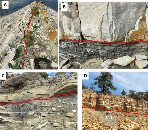
5.2.2 Windy Hill Sandstone
At all three localities, the Windy Hill Sandstone is composed of very fine-grained, laminated, rippled and cross-bedded, quartz-rich sandstone with limited invertebrate traces, but abundant dinosaur and pterosaur tracks. Heterolithic bedding, interference (ladderback) ripples, bidirectional current indicators, sigmoidal bedding, washout surfaces and abundant reactivation surfaces are common throughout the well-exposed sandstone bodies of the Windy Hill Sandstone; all of which are characteristic of, although not exclusive to tidal environments (Flemming, 2012; Nio et al., 1980, 1983; Ramsay et al., 1989; Uhlir et al., 1988; Visser, 1980; Yang & Nio, 1985). In contrast to the ichnological and sedimentological indicators of storm-dominated coastlines in the Redwater Shale, the Windy Hill Sandstone is characterised by features common in low energy, tidal flat and lagoonal settings.
At Alcova, the compound dunes 75 cm high resemble modern examples observed in Cobequid Bay, Bay of Fundy (see Olariu et al., 2012, Figure 3A) in architecture and sedimentary structures, however, they are smaller (Figures 4 and 9A). This suggests that these deposits are consistent with accumulation in a lagoon or moderate to high energy tidal flat setting (Dalrymple et al., 2012; Olariu et al., 2012). Pteraichnus is preserved in rippled beds capping the compound dunes. Bars and channel deposits are not observed at Alcova, suggesting that the environment was a broad tidal flat not exposed to storm waves or deep tidal scour. It should be noted that the succession above the two lowest sandstone bodies at Alcova could be interpreted as either the Windy Hill Member or Lake Como Member. Either way, it accumulated in a low energy setting such as a mid-flat tidal flat (see Klein, 1971).
At Glendo, the Windy Hill Sandstone consists of a series of three stacked, 1.5–3.5 m thick subtidal mouth bars that have a sharp basal contact with the underlying Redwater Shale (Figures 6 and 10). The presence of large bivalve or anemone traces (Conichnus), some of which show evidence of vertical migration of the inhabitants in response to episodic bursts of sediment delivery requires marine or brackish water (Dashtgard & Gingras, 2012; Knaust, 2017). Dinosaur and pterosaur tracks preserved within this succession demonstrate that low-tide during the accumulation of these bars was not deeper than 10–30 cm (indicated by Pteraichnus and small theropod tracks respectively). Significantly, no intervening delta front or shoreface deposits are found between the tidal mouth bars and the underlying offshore siltstone and claystone of the Redwater Shale, thereby breaking Walther's Law.
A potential present-day depositional analogue to the Windy Hill Sandstone in south-eastern Wyoming is the Laguna Madre of the southern coast of Texas, USA, where a 195 km long, sandy, storm and wave-dominated barrier island protects a shallow, tide-dominated lagoon from wave attack. Although it occurs on a microtidal coastline, the sedimentary and biogenic processes observed in the Laguna Madre are a good analogue for those inferred in the Windy Hill. On the shoreline, tidal creeks and rivers rework and deliver sand to a relatively quiet-water system prone to hypersalinity with 40–60 ppt (Buskey et al., 1998). One significant difference between the Laguna Madre system and the Windy Hill, is that the tidal influence in the Laguna Madre is limited by the few, widely spaced inlets on the barrier island and is therefore microtidal, whereas the Windy Hill appears to have experienced a high-mesotidal to low-macrotidal range of (approximately 2–3.5 m) based on the classification of Hayes (1979).
Progradation of tidal flats during a forced regression is a generally overlooked depositional model but was previously interpreted in the Lower Cambrian Gog Group of the southern Canadian Rocky Mountains (Desjardins et al., 2012). Within the Gog Group, the juxtaposition of intertidal flats upon more distal facies records a less extreme fall in sea level than that of the Windy Hill Sandstone /Redwater Shale contact. Sandy subtidal parasequences of the Gog Group are composed of coarsening-upward successions of thin-bedded mudstone and ripple laminated sandstone to thick-bedded, cross-stratified sandstone. The uppermost units of these successions are truncated by an erosional surface that places thinly interbedded mudstone and siltstone tidal flat deposits upon heavily burrowed Skolithos piperock of a shallow subtidal to inner-shelf sand-sheet complex front (Desjardins et al., 2012). Formation of a Regressive Surface of Marine Erosion (RSME) by tidal scouring and wave action removed the upper part of previously deposited subtidal sands. This resulted in an erosionally based tidal-flat facies similar to the Windy Hill Sandstone and a facies jump such that high-energy, shallow-subtidal deposits are lacking, echoing the lack of high energy, wave-dominated deposits in the Redwater Shale. In the Gog Group, however, deeper subtidal deposits are preserved, unlike the absence of tidal deposits in the Redwater Shale and abundance of wave-generated deposits.
The Han River delta has previously been proposed as an analogue for the Windy Hill Sandstone and presumably correlative Redwater Shale and Upper Sundance Formation (Holland & Wright, 2020). The Han River is characterised by a steep catchment and limited floodplains (Cummings et al., 2015), neither of which matches the very extensive, ramp-like geometry of the latest Jurassic sedimentary basin recorded in south-central Wyoming (see Owen et al., 2015). The Han River delta is macrotidal with an average tidal range of 7 m, a maximum tidal range of 9 m and very limited wave influence (Cummings et al., 2015). By contrast, the Redwater Shale in southern Wyoming exhibits strong storm-wave influence supported by the presence of abundant storm beds (FA 2 and FA 3), and evidence for tidal influence in the Redwater Shale is lacking. The tidal bars of the Han River delta consist of variably bioturbated, non-cyclic, interlaminated mud and sand deposits that are up to 27 m thick and > 50 km long, extending basinward (Cummings et al., 2015). By comparison, the tidal bars in the Windy Hill Sandstone at Glendo are 1–3.5 m thick (Figure 10) and are regularly bedded with rhythmic alternations of very fine-grained sandstone and silty sandstone, although, the limited outcrop exposure basinward makes it impossible to determine how far they can be traced. No tidal channels or taller subtidal bars are present at any of the study areas in southern Wyoming, and the preponderance of evidence points to shallow, intertidal flats and subtidal bars building into lagoons. Examination of Redwater Shale and Upper Sundance Formation deposits outside the main study area, in the Bighorn and Wind River basins, suggests that the metre-scale, cross-bedded macroforms are not large-scale tidal bar deposits, but bioclastic, subtidal compound dunes and tidal inlets, as described by Uhlir et al. (1988). Finally, the distributary channels of the Han River are 10–40 m deep and filled with tidal sediment, whilst throughout the study area, the Windy Hill Sandstone is consistently 6 m thick and no evidence of fluvial distributary channels more than 6 m deep have been found, instead, the distributaries in the Windy Hill Sandstone are extremely shallow (<2 m) and do not cut down further than the depth of the underlying sandy tidal flat or mouth bar deposits (Figures 9C and 10C).
The ichnological, sedimentological and stratigraphic data suggest that in south-eastern Wyoming, the Windy Hill Sandstone formed as a mosaic of tidal flat, tidal bar and small tidal creek or distributary channels in a series of lagoons protected from storm waves. The sharp contact between the Windy Hill Sandstone and the underlying, offshore to lower shoreface deposits of the Redwater Shale and gradational upper contact with the mixed fluvial/aeolian main body of the Morrison Formation suggests deposition during a forced regression and falling sea level (see Desjardins et al., 2012; Knaust, 2017, figure 3.2; Neal & Abreu, 2009). The presence of ephemeral sedimentary barriers formed by storm wave reworking of wave-eroded shoreface deposits is suggested by the existence of shallow, tidal lagoons on an otherwise storm-dominated coastline, however, their transitory nature means that they are unlikely to be recognised in the stratigraphic record. Such barriers could have formed during pauses in the shoreline retreat accommodated by sediment compaction (see Brain et al., 2012).
5.2.3 Sequence stratigraphy
The Redwater Shale to Windy Hill and Upper Sundance interval is universally recognised as a progradational (regressive) succession following initial retrogradation (transgression) at its base, although the drivers and characterisation (normal versus forced) of the regression are debated (Danise & Holland, 2018, Danise et al., 2020; Holland & Wright, 2020). Given the wide spatial distribution of outcrops and their relative proximity to tectonic uplifts, it is probable that different influences were acting on deposition and erosion of the basal Windy Hill Sandstone and its correlative deposits at different times and places. The resulting variable expression of their contact with the Redwater Shale is analogous to the J-3 unconformity which records allocyclic and autocyclic drivers of stratal stacking (Zuchuat et al., 2019).
An observation-based framework, wherein only the geometric relationship of the strata is used to delineate systems tracts was introduced by Neal and Abreu (2009) and is adopted here (Figure 17). In south-eastern Wyoming, the Redwater Shale is an aggradational to progradational (AP) succession as confirmed by the presence of shoaling-upward, offshore to lower shoreface deposits at Seminoe and Alcova reservoirs. The lithological and ichnological gap at the base of the Windy Hill Sandstone records the absence of proximal shoreface and foreshore environments and instead documents the placement of intertidal flats, bars and subtidal dunes directly on lower shoreface and offshore deposits, constituting degradation (D), therefore the stratigraphic pattern observed in the outcrops matches that predicted by the model (Figure 17A). A similar type of lithological gap also exists in the Wind River and Bighorn basins, where bioclastic, tidal compound dunes and tidal inlet deposits of the Upper Sundance Formation abruptly contact and incise the Redwater Shale (Uhlir et al., 1988).
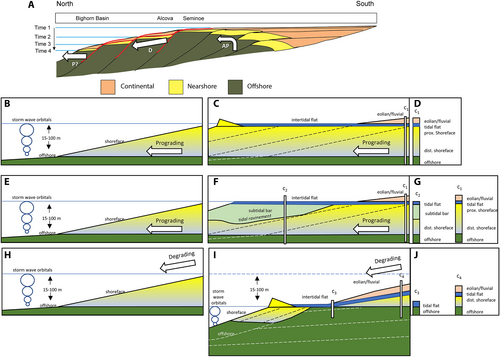
If the Windy Hill Sandstone formed as part of a normal regression (prograding systems tract) in southern Wyoming, with constant or rising sea level, it is necessary to invoke deep tidal scour (Figure 17F) to account for the sharp emplacement of intertidal facies on offshore and lower shoreface storm deposits of the Redwater Shale (Holland & Wright, 2020). In which case, the tidal facies would necessarily reflect the water depth of the precursor shoreface deposits that were removed, which is estimated to be between 5 and 15 m at Seminoe and 15–100 m at Alcova and Glendo, thicknesses based on general guidelines gleaned from modern wave-dominated coastlines (Keen et al., 2012) and observations of other Mesozoic shorefaces in the Western Interior. Emplacement of intertidal (possibly subaerially exposed) deposits on Cruziana Ichnofacies-bearing, offshore to lower shoreface deposits is not achievable in the absence of a degrading shoreline trajectory and development of a RSME (Figure 17I).
Episodic pauses in a forced regression, combined with compaction-induced subsidence would have facilitated a high-frequency aggradation to retrogradation (AR) systems tract development, superimposed upon the lower frequency degradation (D). This resulted in storm-generated construction of ephemeral transgressive barrier islands, spits and bars, from the wave-reworked, falling stage shorefaces, behind which physicochemically stressed tidal lagoons accumulated. Subaerial exposure of these back-barrier tidal flat and tidal bar deposits prior to inundation by simultaneously prograding coastal aeolian dunes and fluvial systems is consistent with the landward expression of a developing sequence boundary, time-equivalent to the submarine, basal Windy Hill Sandstone unconformity (Figure 17A).
5.2.4 Tectonic forcing of sea level
The progressively deeper truncation by the basal Windy Hill Sandstone towards the Colorado Front Range is indicative of tectonic uplift during the Middle and Late Jurassic (Figure 2; Pipiringos, 1957). Evidence of active uplift of the Sheridan Arch in the Bighorn Basin prior to and during accumulation of the Upper Sundance Formation in Wyoming includes the erosional contact and reworked clasts of older Jurassic strata within incised tidal inlets of the Windy Hill Sandstone -equivalent in the Bighorn Basin (Clement & Holland, 2016; Danise & Holland, 2017; Holland & Wright, 2020; McMullen et al., 2014; Schmude, 2000). Additional fieldwork in the Wind River and Bighorn basins has confirmed the existence of tidal inlets incised 5–15 m into the Redwater Shale, these contain rip-up clasts and extraformational pebbles within the basal lags. The Sheridan Arch was actively uplifting and at times was subaerially exposed earlier in the Jurassic, prior to the major transgression heralding deposition of the Redwater Shale (Imlay, 1957; Kilibarda & Loope, 1997; West, 1984). This is recorded in the Redwater Shale which thins from >50 m thick in the southern Bighorn Basin to 20–25 m near Laramide-aged structures such as the Wind River Range and Sheridan Arch (Danise & Holland, 2018; McMullen et al., 2014), providing additional evidence for active uplift of these features in the Oxfordian. These structural uplifts forced regression during the Oxfordian and exposed previously buried Jurassic deposits to erosion and redeposition, resulting in development of the regionally complex J-5 unconformity (Pipiringos & O'Sullivan, 1978).
The rapid drop in relative sea level was accompanied by seaward progradation of mixed aeolian and fluvial systems of the main body of the Morrison Formation. Sand derived from the eroding uplifts and winnowed from the exposed shoreface deposits was delivered to the developing lagoons to form the Windy Hill Sandstone tidal flat system. The limited volume of clastic sediment delivered by Oxfordian fluvial systems is evidenced by the basal Tidwell Member of the Morrison Formation in Utah and western Colorado which is marked by a prominent gypsum bed that is almost 14 m thick locally, or a tabular sandstone bed that separates the Tidwell from the underlying, marginal marine Summerville Formation (Carpenter, 2022; Kirkland et al., 2020; O'Sullivan, 1980, O'Sullivan, 1984; Peterson, 1988). This sandstone bed has been correlated to the Windy Hill Sandstone in south-eastern Wyoming due to its location above the J-5 unconformity (Peterson, 1988) and strata referred to as Windy Hill Sandstone are conformably overlain by the Tidwell Member in the northern Uinta Basin, eastern Utah (Carpenter, 2022; Sprinkel et al., 2019).
5.3 J-5 unconformity as a composite sequence boundary
Pipiringos and O'Sullivan (1978) were uncertain about the nature of the J-5 unconformity in northern Wyoming and Montana, but implied it was represented by the variable thickness truncation of the Swift Formation by the overlying Morrison Formation. They explicitly tied development of the J-5 unconformity to tectonic uplift and forced regression (Pipiringos & O'Sullivan, 1978; p. 25) and suggested it was of less than 2 Myr duration.
A sequence boundary is not necessarily a uniform bypass surface, a timeline or a single, unmodified unconformity. Instead, it is a composite surface with continuous deposition at some point in three-dimensional space for its terrestrial and marine duration (Holbrook & Bhattacharya, 2012; Holbrook & Miall, 2020; van Yperen et al., 2020). This is reflected in the accumulation of aeolian and fluvial deposits of the main body of the Morrison Formation during the time of falling Oxfordian sea level and truncation of shoreface deposits in the Redwater Shale. Studies of composite sequence boundaries and their relationships to time-equivalent deposits up-dip and down-dip of their active segments has demonstrated that development of these surfaces is not only diachronous, but at times, highly localised (Holbrook & Bhattacharya, 2012; Holbrook & Miall, 2020; van Yperen et al., 2020).
The J-5 unconformity is a regional erosional surface that can be traced over a large portion of the Western Interior Basin (Pipiringos & O'Sullivan, 1978) thereby fulfilling the first criterion for identification of a sequence boundary. The sharp stratigraphic contact between the proximal, intertidal deposits of the Windy Hill Sandstone and offshore to lower shoreface deposits of the Redwater Shale in south-eastern Wyoming qualify it as a sequence boundary marked by an abrupt basinward shift in facies. At Glendo and Seminoe, paedogenic modification in the upper Windy Hill Sandstone, potentially representing limited landward expression of the sequence boundary is present as predicted by the sequence stratigraphic model (Figures 9C and 17A). If the Windy Hill Sandstone is a strongly progradational to degradational (PD) deposit that accumulated behind ephemeral storm-dominated barriers during a forced regression, it too represents a time-transgressive unit that is progressively younger to the north, but age-equivalent to the developing RSME (sequence boundary) basinward of the tidal flat complex.
The distinctly planar nature of the J-5 unconformity is a result of the lack of a shelf-slope break to facilitate incision of coastal rivers during sea-level fall in the study area. The basal Windy Hill Sandstone RSME contrasts dramatically with subaerial, fluvially eroded sequence boundaries that exhibit irregular topography. Incised valley fills have not been recognised anywhere in the Windy Hill Sandstone or overlying, main body of the Morrison Formation, which is consistent with lengthening but not entrenchment of small, distributive rivers during relative sea-level fall and failure of a knickpoint to form that would facilitate landward propagation of fluvially incised valleys (see Mackey et al., 2014). Instead, rivers continued to elongate and eventually failed to deliver sediment into the retreating marine basin, leading to accumulation of mud-rich successions of coastal plain and lagoon deposits punctuated by thin, sand-prone frontal splays and single storey channels (Connely, 2006). In this way, accumulation of the mixed aeolian and fluvial main body of the Morrison Formation continued essentially uninterrupted onshore as a forced regressive, deep wave scour of the Redwater Shale progressed basinward during the falling sea-level cycle in a pattern common to other systems (Holbrook & Bhattacharya, 2012; Holbrook & Miall, 2020; van Yperen et al., 2020).
Composite erosional surfaces have been documented at other unconformities (Blum & Valastro, 1994; Holbrook & Bhattacharya, 2012; Holbrook & Miall, 2020; van Yperen et al., 2020), including the J-3 unconformity (Zuchuat et al., 2019). The J-3 unconformity is unlike the J-5, however, because it formed via aeolian deflation, flash-flood driven fluvial incision, transgressive tidal ravinement, tidal scouring during normal regressions and structural deformational processes (Zuchuat et al., 2019). None of these mechanisms would achieve the observed pattern of shallow, intertidal flat deposits that make direct stratigraphic contact with offshore and lower shoreface deposits. For example, transgressive ravinement during the Redwater Shale to Windy Hill Sandstone transition would result in an increase in local water depth, from upper shoreface to lower shoreface and offshore, accompanied by a landward migration of the shoreline. This is the opposite of what is observed, wherein upper shoreface deposits are missing and instead, proximal tidal flat deposits have migrated basinward. Likewise, aeolian deflation would have no effect on shoreface deposits of the Redwater Shale and normal regression would result in proximal shoreface deposits or subtidal deposits prograding over distal shoreface deposits before being followed by intertidal flat deposits (Figure 17C). This contrasts with the prograding of intertidal flats, tidal inlets and tidal dunes directly over lower shoreface to offshore deposits that is observed in the Windy Hill and Upper Sundance/Redwater Shale contact across Wyoming (Danise & Holland, 2017, 2018; Holland & Wright, 2020). There is no evidence for fluvial incision at the contact either (Holland & Wright, 2020), although the Sheridan Arch, ancestral Front Range and Uncompahgre Uplift, helped drive the regional drop in relative sea level and created palaeobathymetric high spots that may have amplified tidal currents (Dean et al., 2019; Zuchuat et al., 2022). Of all the candidate mechanisms for generating a regionally widespread, basinward-step in facies, the only one that accounts for all the sedimentological, ichnological and stratigraphic characteristics of the J-5 unconformity in southern Wyoming is a forced regression caused by tectonic uplift of the ancestral Front Range and other pre-Laramide structures, which progressively migrated from southern Wyoming to northern Wyoming.
If the Upper Sundance and Redwater members 230 km north of Alcova in the Bighorn Basin are conformable as proposed by Holland and Wright (2020), it suggests that the degradational (D) basinward movement of the shoreline changed to a normal, progradation (P) regression. The J-5 unconformity identified in southern Wyoming is necessarily correlative to older, offshore deposits of the Redwater Shale in the Bighorn Basin because sediment transported basinward by wave erosion would be entrained by geostrophic currents and reworked into offshore deposits (Figures 2 and 17A). It is difficult or impossible to recognise the correlative strata from field observations alone, but chemostratigraphic analysis might be useful (Harris et al., 2022). However, additional field investigation of the J-5 interval in the Wind River and Bighorn basins does not support the hypothesis that the succession is conformable (Dean et al., 2019; Zuchuat et al., 2022). Instead, just as in south-eastern Wyoming, there is a significant basinward shift in facies.
5.4 A no-analogue depositional system?
In palaeoecology and ecological forecasting studies, a no-analogue community or climate is one that is compositionally different from a typically modern baseline for measurement (Faith & Lyman, 2019; Williams & Jackson, 2007). Extending this concept to sedimentological and palaeoichnological studies acknowledges the uniqueness of systems in deep time while recognising that analogues to components of the systems such as sedimentary and biogenic processes can still be useful tools to deciphering the system. The epeiric, greenhouse setting of the Sundance Sea and its fauna of marine reptiles, belemnites and ammonites has no analogue in modern biomes or physiographic settings. The physical and biological processes such as tides, waves, storms and burrow construction that affected sediment accumulation have analogues in modern and ancient systems, however, and can be used to construct a depositional model.
Sequence stratigraphic and ichnological studies of the fluvial-to-marine transition have largely focussed on modern passive margins and ancient foreland basins with discrete knickpoints (Blum & Valastro, 1994; Krystinik & DeJarnett, 1995; Anderson et al., 2008, 2016; Hubbard et al., 2004; Dalrymple & Choi, 2007; MacEachern & Gingras, 2007; Wallace & Anderson, 2013; Gingras et al., 2016). In these settings, during a forced regression, falling sea level leads to fluvial incision at the knickpoint and the development of landward-migrating incised valleys. These incised valleys are filled with a mosaic of fluvial, deltaic, bay and shelf deposits, reflecting the turnaround from regressive fluvial sedimentation to transgressive estuarine and marine accumulation (Shanley & McCabe, 1994; Weimer, 1992). Common features in many previously studied systems are the humid sub-tropical to tropical climate, unrestricted connection to open marine basins, and constant flow of freshwater from rivers. The semi-enclosed basin, dry climate and ramp like setting of the Jurassic Western Interior Basin contrasts with the humid Cretaceous Western Interior foreland basin and modern Gulf of Mexico, and it does not conform to stratigraphic, sedimentological or ichnological predictions based on these analogues. There is a lack of incised valleys at the J-5 unconformity, however, the presence of tidally deposited sandstone directly above the unconformity necessitated sand delivery either through aeolian or non-incising fluvial processes during a sea-level fall (Figure 18B,C).
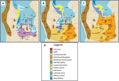
Although the Sundance Sea and its associated marine and continental deposits have no strict modern depositional or ichnological analogues, some sedimentary basins and environments such as the modern Texas Gulf Coast and the Triassic Western Canadian Sedimentary Basin in Alberta, Canada are partial analogues in terms of sedimentary processes, biogenic features, and certain aspects of bathymetry and geography (Davies, 1997; Wüst et al., 2018). Similar to the Sundance Sea, the Triassic Western Canada Sedimentary Basin (WCSB) existed in a greenhouse world and was semi-isolated from the proto-Pacific and bounded to the west by a volcanic arc. Shelfal bottom currents and longshore drift circulated open marine waters into the basin and the palaeoclimate was seasonally arid with ephemeral fluvial systems delivering clastic sediments to the basin (Wüst et al., 2018). As with the Windy Hill Sandstone and the overlying main body of the Morrison Formation, aeolian deposition was a major factor in sand distribution to the WCSB during the early Triassic (Davies, 1997). Unlike the Sundance Sea, the record of marine deposition within the Montney Sea of the WCSB includes pronounced turbidite accumulation (Moslow & Davies, 1997), with a diverse assemblage of marine benthic organisms that left a rich ichnofossil record towards the base of the formation (Zonneveld et al., 2010). Some of the ichnofossil assemblages are similar in taxonomic composition and diversity to those in the Sundance Sea. The Sundance and Montney seas are possibly more similar to each other than either is to the Cretaceous Western Interior with its generally unrestricted access to the Gulf of Mexico and Arctic Ocean, or modern marine basins, thereby providing a potential range of analogues (aggrading and prograding deepwater turbidites versus degrading, regressive shoreface to tidal deposits) to other semi-enclosed, arid-climate, marine foreland basins in greenhouse environments. With no analogues in the modern world, documenting the key similarities and differences between other epeiric seaway deposits in deep time is crucial to understanding the small and large-scale dynamics of stratal surface generation, lithofacies and ichnofacies distribution, and the location of potential geothermal, carbon capture and hydrocarbon targets.
6 CONCLUSIONS
- The Redwater Shale hosts a Cruziana Ichnofacies typical of open marine, wave-dominated, offshore to lower shoreface environments. A Pteraichnus Ichnofacies, diagnostic of intertidal and shallow subtidal flat environments characterises the Windy Hill Sandstone, which also contains small and large dinosaur tracks and an impoverished Skolithos Ichnofacies.
- Ichnological data bolster and support previous geochemical data-based interpretation of minimal restriction of the Sundance Sea during the Oxfordian.
- The abrupt contact of Pteraichnus and impoverished Skolithos upon Cruziana Ichnofacies is characteristic of a RSME and forced regressive emplacement of proximal upon distal facies (Knaust, 2017, figure 3.2).
- Sedimentological data reinforce conclusions drawn from ichnology. Glauconitic deposits of the Redwater Shale indicate warm marine waters with low rates of sediment accumulation, oxygen deficiency and minimal disturbance by wave action in an offshore environment. Storm beds, composed of shell coquina and very fine-grained sandstone recording HCS to SCS, are diagnostic of storm wave-driven sediment delivery to the offshore-transition and lower shoreface zone. The most proximal facies identified in the Redwater Shale is lower shoreface. Proximal shoreface, foreshore, tidal channel and tidal bar deposits are absent.
- Tidal bars, composed of laterally accreting sets of very fine-grained, ripple laminated sandstone, compound tidal dunes and intertidal flat deposits comprise the Windy Hill Sandstone in southern Wyoming. Compared to the Redwater Shale, depositional energy was low, water was significantly shallower, and the abundance of well-preserved Pteraichnus and dinosaur tracks suggests rapid accumulation (1,341–1,719 years for the 5.5 m thick succession at Seminoe) and presence of microbial mats. The sharp contact of the intertidal Windy Hill Member upon the offshore to lower shoreface Redwater Shale is diagnostic of a RSME (a sequence boundary) and a basinward shift in facies associated with a degrading shoreline trajectory.
- Tidal range, calculated independently from bar height (1–3 m), dune foreset height (3–5 m) and tidal flat succession thickness (2–3.5) was 1–5 m.
- The J-5 unconformity surface in south-eastern Wyoming is a composite sequence boundary, propagating northward, and formed in response to falling sea level that was driven by the tectonic uplift of structural elements such as the ancestral Front Range in Colorado and the Sheridan Arch in Wyoming.
- Even though components of the Jurassic WIS such as sedimentary processes, biological processes, hydrology, bathymetry and geography can be interpreted using analogues, the system as a whole has no strict modern geographic, sedimentary or ecological analogues. The Triassic Western Canadian Sedimentary Basin (WCSB), which was also a restricted, retroarc foreland basin is a partial palaeogeographical and depositional analogue for the Jurassic WIS, but even then, the turbidite deposits of the Montney Formation, the record of the Montney sea within the WCSB, have no equivalents in the Sundance Formation, suggesting that the latter is an example of a no-analogue system.
ACKNOWLEDGEMENTS
We gratefully acknowledge the Rocks2Models research group and C. Johnson for the use of the drone in data collection for this study. In addition, G. Hampson, S. Holland, G. Plint and V. Zuchuat are acknowledged and thanked for their thorough reviews, critiques and suggestions which greatly improved the quality of this manuscript. We deeply appreciate P. Swart's and V. Zuchuat's gracious and patient shepherding of this contribution through the editorial process.
Open Research
DATA AVAILABILITY STATEMENT
Data sharing is not applicable to this article as no new data were created or analyzed in this study.


