Assessment of Suitable Habitats, Fragmentation Analysis, and Ecological Corridor Identification for Sichuan Golden Snub-Nosed Monkey (Rhinopithecus roxellana) in Sichuan Province, Southwest China
ABSTRACT
The Sichuan golden snub-nosed monkey (Rhinopithecus roxellana) was found to possess significant scientific and conservation value but faced multiple threats including habitat fragmentation and loss, human disturbance, illegal hunting, and the impacts of climate change on their habitat. To enhance habitat protection for this species, our study utilized field survey data and distribution records from protected areas to systematically evaluate spatial heterogeneity in suitable habitat distribution and habitat quality in Sichuan Province. Integration of 3S technology and ecological modeling allowed for a comprehensive assessment. We found that: (1) The potential habitat area for the species in Sichuan Province covered 78,470.47 km², with suitable and marginally suitable habitats occupying 28,301.36 and 50,169.11 km² respectively. Suitable habitats were predominantly found at elevations of 1600–3200 m, in areas with low population density and minimal human disturbance. (2) Suitable habitats within protected areas accounted for 42.7% of the total suitable habitat area, while marginally suitable habitats within protected areas comprised 24.8% of the total marginally suitable habitat area. (3) Vegetation types most utilized by the species, ranked from highest to lowest preference, were deciduous broadleaf forests, evergreen coniferous forests, evergreen broadleaf forests, mixed coniferous-deciduous forests, and shrublands. Evergreen coniferous forests exhibited the largest patch area and lowest fragmentation, whereas deciduous broadleaf forests showed higher fragmentation within protected areas. (4) Four potential ecological corridors were identified, connecting the Wujiao, Xuebaoding, and Baodinggou nature reserves. Strengthening the protection of suitable habitats and potential ecological corridors would enhance landscape connectivity, facilitating the effective utilization of suitable habitats by the Sichuan golden snub-nosed monkey. Our findings provided a scientific basis for future conservation and management efforts for the Sichuan golden snub-nosed monkey.
Summary
-
The study found that the potential habitat for the Sichuan golden snub-nosed monkey in Sichuan Province covers 78,470.47 km², with suitable habitats primarily at elevations of 1600–3200 m.
-
Suitable habitats within nature reserves account for 42.7% of the total suitable area, emphasizing the importance of protected areas in conservation efforts.
-
Four potential ecological corridors were identified, and the study highlighted the need to protect these corridors to improve landscape connectivity and habitat utilization by the species.
1 Introduction
Habitat fragmentation has negatively impacted the integrity of wildlife habitats, increasing the costs associated with species migration and dispersal within fragmented habitats (Collingham and Huntley 2000; Pearson and Dawson 2005). Accurate identification and effective conservation of suitable habitats are crucial for addressing habitat fragmentation issues, particularly prioritizing the protection of potentially suitable habitats, which enhances biodiversity richness (Dai et al. 2021; Dai et al. 2023). Habitats not only provide living space for various organisms but also essential resources such as food, water, breeding sites, and shelter (Nagelkerken et al. 2008). Globally, many species depend on specific types of habitats to maintain the stability of their life cycles and populations (Nagelkerken et al. 2008). However, with the expansion of human activities and increased resource development, many habitats face severe threats and degradation, resulting in increased risks of species extinction and loss of biodiversity (Tilman et al. 2017). Protecting habitats is not only about safeguarding individual species but also maintaining crucial components of entire ecosystems. The significance of habitat conservation lies in its ability to provide the complex spatial structure and resources required for species diversity and ecosystem functions (Hughes et al. 2018). Habitat protection not only helps prevent species extinction but also maintains ecosystem stability, reducing declines in ecosystem services and negative impacts from environmental changes (Kilpatrick et al. 2017).
Against the backdrop of intensifying global climate change and human disturbances, enhancing habitat conservation efforts has become particularly urgent and critical (Opdam and Wascher 2004; Zhao et al. 2019). Implementing effective conservation measures, such as establishing and managing protected areas, restoring degraded ecosystems, and reducing illegal wildlife trade, can effectively safeguard sustainable biodiversity and long-term ecosystem health (Bullock et al. 2011; Morton et al. 2021; Naughton-Treves, Holland, and Brandon 2005). Habitat conservation is not only a crucial means of protecting the natural environment but also forms the foundation for maintaining global biodiversity and human well-being (Hausmann et al. 2016). In the context of climate change, assessing species' suitable habitats has become a pivotal research focus in contemporary ecology and conservation biology (Dai et al. 2021). As global temperatures rise and environmental changes escalate, the survival habitats of many species are severely threatened (Şekercioğlu, Primack, and Wormworth 2012). To better understand and predict the impacts of these changes on species habitats, researchers employed various models and technologies for comprehensive assessment and analysis. These assessments not only focus on the current distribution of suitable habitats for species but also address habitat fragmentation levels and the identification of potential ecological corridors (Opdam and Wascher 2004; Nuñez et al. 2013; Li et al. 2018). This approach is essential for proposing effective conservation strategies and management recommendations.
In the assessment of species habitat suitability, commonly utilized methods include ecological modeling, remote sensing techniques, and geographic information systems (Li et al. 2018; Liu et al. 2020). Ecological models utilize climate data, terrain information, and species distribution records to accurately quantify the impact of climate change on species' suitable habitats (Li et al. 2018; Dai et al. 2023). These models not only assist in predicting habitat changes but also elucidate species responses to environmental changes. Remote sensing provides a robust tool for assessing habitat fragmentation by acquiring extensive and high-resolution land cover information, facilitating accurate analysis and monitoring of habitat change trends, and identifying potential ecological corridors and priority conservation areas (Luo et al. 2016). Geographic information systems play a crucial role in integrating and analyzing spatial data, providing an efficient platform for assessing species habitat (Ortigosa, De Leo, and Gatto 2000). Through the application of 3S technologies, researchers can comprehensively consider various geographical and environmental factors to precisely evaluate habitat quality and suitability, thereby offering a scientific basis for conservation and management decisions (Correa Ayram et al. 2016). The integrated application of these methods not only enhances the accuracy and predictability of assessments but also provides crucial scientific support in addressing ecological challenges such as climate change. A deep understanding of the relationship between species and their habitats enables more effective formulation of conservation strategies, ensuring sustainable development of biodiversity and ecosystem health.
The construction of ecological corridors aims to facilitate the smooth migration of different species across fragmented habitat patches (Dai et al. 2021). Identifying and protecting these corridors effectively promotes wildlife utilization of habitats, providing suitable spaces for species (Li et al. 2018). The primary goal of ecological corridors is to enhance the integrity of fragmented landscapes, making it a highly practical and operational method for species conservation, grounded in principles of landscape ecology (Liang et al. 2018). Currently, researchers focus on corridor types, composition, applications, and functions, which are key areas of current research interest (Li et al. 2018; Liang et al. 2018; Luo et al. 2016; Dai et al. 2021). In corridor construction, Least-cost path method is one of the most commonly used methods. It not only considers the shortest distances between sources but also integrates actual costs of species migration processes (LaRue and Nielsen 2008; Yang et al. 2023). The establishment of ecological corridors significantly improves connectivity among habitat patches, facilitating biological migration and exchange in fragmented landscapes (Li et al. 2018; Liang et al. 2018; Luo et al. 2016). This helps mitigate risks associated with inbreeding and reduces the threat of species extinction. Strengthening the development of ecological corridors not only contributes to biodiversity conservation but also enhances the ecosystem services of landscapes, providing crucial support for the sustainable development of human societies and natural environments.
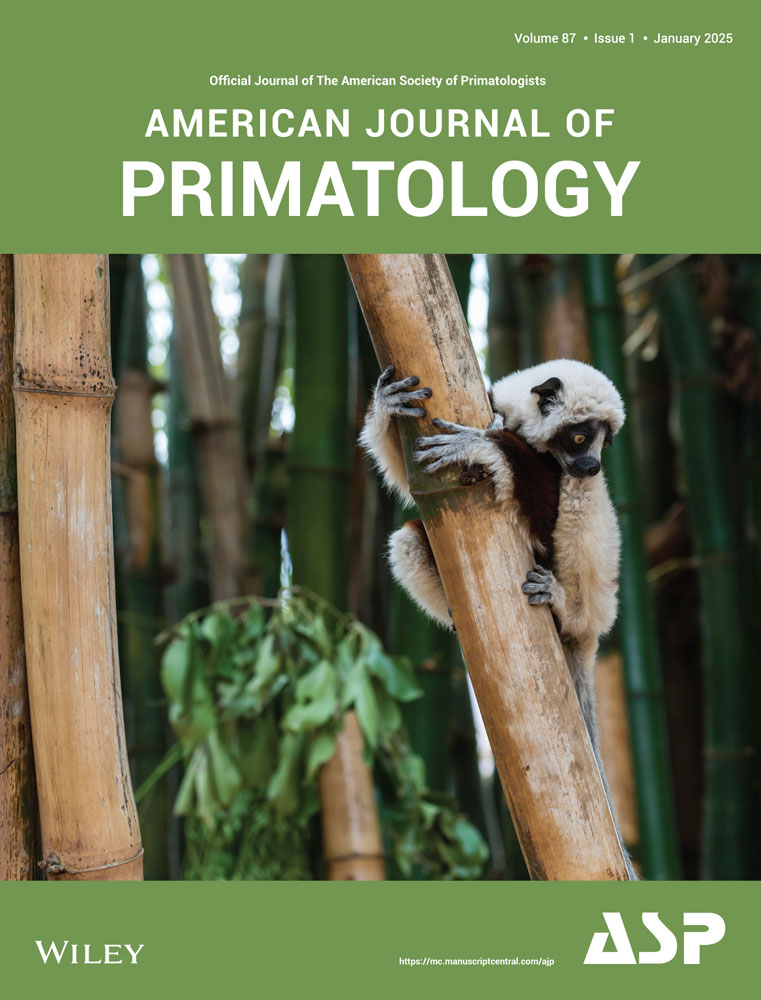
Currently, the population of the Sichuan golden snub-nosed monkey (Rhinopithecus roxellana; Figure 1) is estimated to be around 22,000 individuals, with approximately 16,000 in Sichuan and Gansu Provinces, about 5500 in Shaanxi Province, and around 1000 in Hubei Province (Arroyo-Rodríguez and Dias 2010; Chang et al. 2012). In Sichuan Province, these monkeys were historically distributed across mountain ranges such as Qionglai, Minshan, Daxiangling, and Xiaoxiangling, but their range has significantly contracted (Dong et al. 2019). The primary threats to the species include habitat fragmentation and loss, human activities such as deforestation and road construction, hunting, illegal capture, and the obstruction of ecological corridors. Additionally, climate change poses a growing threat, altering the availability of suitable habitats and exacerbating the effects of habitat fragmentation (Zhao et al. 2019). To effectively protect this species, our study utilized field survey data and distribution records from protected areas to systematically evaluate the spatial heterogeneity of suitable habitat distribution and habitat quality for Sichuan golden snub-nosed monkeys in Sichuan Province. Using 3S technologies and an ecological niche model, we identified potential ecological corridors based on the Least-Cost Distance Model, taking into account vegetation patches of suitable habitats and the degree of habitat fragmentation. Furthermore, we proposed targeted conservation measures to address these threats, with a focus on mitigating the impacts of climate change and ensuring ecological connectivity. Our findings provide valuable insights for the conservation of Sichuan golden snub-nosed monkeys and other primates, emphasizing the necessity of considering spatial heterogeneity, habitat fragmentation, and climate-related risks in future conservation efforts.

2 Materials and Methods
2.1 Study Area
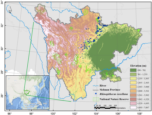
Sichuan Province is located in the upper reaches of the Yangtze River in southwestern China, with east-west and north-south distances of approximately 1000 and 900 km, respectively (Figure 2). It borders Chongqing Municipality to the east and is adjacent to Yunnan and Guizhou provinces to the south, Xizang Autonomous Region to the west, and Qinghai, Gansu, and Shaanxi provinces to the north. With an area ranking fifth in China, Sichuan covers 486,000 km2. The southwestern region of China is known for its high genetic diversity of terrestrial vertebrates, situated between the Qinghai-Tibet Plateau, the ‘Roof of the World’, and the plains along the middle and lower reaches of the Yangtze River (López-Pujol and Zhao 2004). As part of the Southwestern Mountain China, Sichuan Province has been continuously enhancing its ecological protection and restoration efforts. As of 2024, Sichuan has established 166 protected areas at various levels, covering 90% of terrestrial ecosystem types, 95% of key protected wildlife species, 65% of higher plant communities, and nearly 50% of natural wetlands. The total area of priority biodiversity regions in the province is 176,000 km2, accounting for 36% of the total area of Sichuan Province. Sichuan ranks first nationwide in the number of terrestrial wild animal species, with approximately over 1000 vertebrate species, including over 200 mammal species, over 600 bird species, over 80 reptile species, over 90 amphibian species, and over 200 fish species (Forestry and Grassland Bureau of Sichuan Province; http://lcj.sc.gov.cn/). Sichuan Province also ranks first nationally in the number of nationally protected wild animals, accounting for more than one-third of all nationally protected animals in China.
2.2 Data Collection and Processing
2.2.1 Collection of Species Occurrence
From 2010 to 2023, we employed a holistic approach to examine the distribution of golden snub-nosed monkeys. To identify suitable field survey areas, we assessed historical population distribution data while considering factors such as local vegetation types, elevation, and accessibility. After determining our survey locations, we implemented the transect method to capture the spatial distribution of the monkeys. We traversed these transects, documenting the locations of all observed individuals. A GNSS device was used to record the exact coordinates of each sighting. To mitigate the impact of spatial autocorrelation on our model results, we established a 1 km² grid based on the average daily movement distance of approximately 1 km for the golden snub-nosed monkeys (Li 2005). Within each grid, one occurrence was randomly selected and retained (Li 2005). This process resulted in a total of 392 effective occurrences.
2.2.2 Bio-Variables and Environmental Data
To accurately identify the distribution area of Sichuan golden snub-nosed monkeys to the greatest extent possible, we meticulously constructed a relatively comprehensive set of environmental factors based on the species' physiological characteristics, behavioral habits, and previous research findings (Luo et al. 2016; Yu et al. 2022). This ensemble comprises five key geographical, environmental factors, 19 bioclimatic factors, and five anthropogenic disturbance factors (Table 1). By comprehensively considering these factors, we are able to gain a more comprehensive understanding of the habitat requirements of Sichuan golden snub-nosed monkeys, thereby enhancing the accuracy of our predictions regarding their distribution area. We used variance inflation factor to reduce variable collinearity (Supporting Information S1:Appendix 1). Finally, we standardized the spatial coordinates, spatial resolution, and extent of each variable in ArcGIS 10.6 (ESRI Inc.).
| Variables | Code | Description | Data sources |
| Environmental factors | alt | Altitude | http://www.gscloud.cn/; at 30 m resolution |
| asp | Aspect | ||
| slo | Slope | ||
| ndvi | Normalized Difference Vegetation Index | http://www.resdc.cn/; at 1 km resolution | |
| riv | River | https://www.openstreetmap.org/ | |
| Bioclimatic factors | b1 | Annual Mean Temperature | https://www.worldclim.org at 1 km resolution |
| b2 | Mean Diurnal Range [Mean of monthly (max temp - min temp)] | ||
| b3 | Isothermality (BIO2/BIO7) (* 100) | ||
| b4 | Temperature Seasonality (standard deviation *100) | ||
| b5 | Max Temperature of Warmest Month | ||
| b6 | Min Temperature of Coldest Month | ||
| b7 | Temperature Annual Range (BIO5-BIO6) | ||
| b8 | Mean Temperature of Wettest Quarter | ||
| b9 | Mean Temperature of Driest Quarter | ||
| b10 | Mean Temperature of Warmest Quarter | ||
| b11 | Mean Temperature of Coldest Quarter | ||
| b12 | Annual Precipitation | ||
| b13 | Precipitation of Wettest Month | ||
| b14 | Precipitation of Driest Month | ||
| b15 | Precipitation Seasonality (Coefficient of Variation) | ||
| b16 | Precipitation of Wettest Quarter | ||
| b17 | Precipitation of Driest Quarter | ||
| b18 | Precipitation of Warmest Quarter | ||
| b19 | Precipitation of Coldest Quarter | ||
| Anthropogenic disturbance factors | rai | Railway | https://www.openstreetmap.org/ |
| roa | Road | ||
| pop | Population density | http://www.resdc.cn/; at 1 km resolution | |
| rd | Distance to settlements | https://www.openstreetmap.org/ | |
| dd | Other anthropogenic disturbances, such as Grazing and medicinal plant harvesting |
2.3 Habitat Suitability Modeling
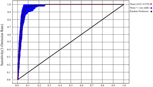
The MaxEnt model surpasses other niche models in terms of predictive accuracy and sample size requirements, making it an ideal method for studying the geographic distribution and habitat suitability of rare and endangered wildlife (Phillips and Dudík 2008). It has been widely employed in assessing the spatial distribution of potential suitable habitats for species. In this study, we utilized MaxEnt 3.4.1 to construct a distribution model for Sichuan golden snub-nosed monkeys. We employed the built-in cross-validation method, repeated the simulation 50 times, set the regularization multipliers to 5, and maintained other parameters at their default values. The habitat suitability index (HSI) was computed as the average of 50 simulation results, and further analysis was conducted using ArcGIS 10.6. HSI has been reclassified into three categories for the model. HSI < 0.05: classified as unsuitable habitat; HSI between 0.05 and 0.3: classified as marginally suitable habitat; HSI > 0.3: classified as suitable habitat. Model performance was evaluated based on the area under the receiver operating characteristic curve (AUC) derived from the receiver operating characteristic curve (ROC). The AUC value ranges from 0 to 1.0, where a higher value indicates better predictive performance of the model. If the AUC is less than 0.5, it indicates the model's predictions are not better than random guessing. AUC values between 0.7 and 0.8 suggest reasonably reliable results, values between 0.8 and 0.9 indicate accurate results, and values between 0.9 and 1.0 indicate highly accurate model predictions (Wei et al. 2018).
2.4 Utilization of Vegetation by the Sichuan Golden Snub-Nosed Monkey
Based on the vegetation utilization characteristics by the Sichuan golden snub-nosed monkey (Li 2007), potential suitable habitat was classified into shrubland, deciduous broadleaf forest, evergreen broadleaf forest, mixed coniferous and broadleaf forest, and evergreen coniferous forest. Spatial utilization density distribution of the Sichuan golden snub-nosed monkey was derived from distribution points, overlaid with vegetation layers. Areas with zero density were excluded, and patches of potentially suitable habitat predicted by the MaxEnt model were analyzed.
2.5 Habitat Fragmentation Analysis
Based on the suitable distribution range determined by the MaxEnt model, we investigated the utilization of vegetation patches by Sichuan golden snub-nosed monkeys within the suitable habitat. This allowed us to discern the species' preferences for utilizing vegetation patches. Subsequently, using Fragstats v 4.2.1, we conducted a fragmentation analysis of the entire suitable habitat patch (McGarigal 2015). Additionally, we assessed the effectiveness of conservation areas by comparing the degree of habitat fragmentation within and outside protected areas. Patch Area (CA): Patch area represents the area of a specific land use type, measured in km2. Its size constrains the survival and development of species associated with the habitat (Zhang et al. 2014). Landscape Shape Index (LSI): Its values range from 1 or greater. As LSI approaches 1, landscape patches are more regular in shape, whereas higher values indicate more complex and irregular landscape patches.
Where gii represents the number of adjacent patches of the same landscape type.
2.6 Landscape Connectivity and Ecological Corridors
3 Results
3.1 Spatial Distribution Characteristics of Suitable Habitat
3.1.1 Model Performance and Contribution Rates of Environmental Variables
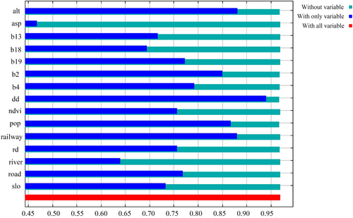
In the model validation, the average AUC value for the test data set was 0.97, and for the training data set, it was 0.96, indicating extremely high accuracy of the model (Figure 3). Through Jackknife tests, the contribution rates of various environmental variables were determined, ranked from highest to lowest as dd, alt, railway, pop, b2, and b4. Predicted suitable habitats were found to be confined to an altitude range of 1600–3200 m, areas characterized by low population density, minimal human disturbance, and, to some extent, distance from high-speed railways (Figure 4).
3.1.2 Distribution Characteristics of Suitable Habitat Within Protected Areas
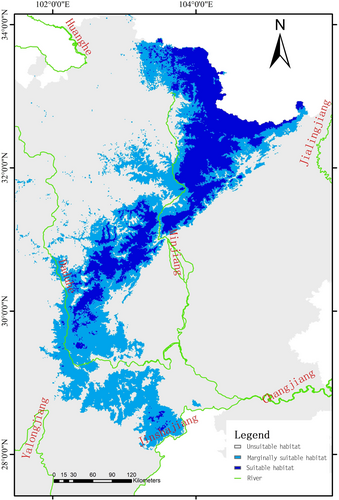
The potential habitat area for Sichuan golden snub-nosed monkeys in Sichuan Province was 78,470.47 km², with suitable and marginally suitable habitats covering 28,301.36 and 50,169.11 km², respectively (Figure 5). Additionally, habitat assessments inside and outside protected areas in Sichuan Province showed that the total area of suitable habitat within protected areas was approximately 12,082.27 km² (Table 2), representing 42.69% of the total suitable habitat. The area of marginally suitable habitat within protected areas was approximately 12,463.26 km², accounting for 24.84% of the total marginally suitable habitat. The potential suitable habitat within protected areas only covered 49.1% of the actual distribution range of Sichuan golden snub-nosed monkeys, indicating significant conservation value in potential suitable habitats outside protected areas.
| Nature reserve | Marginally suitable habitat/km2 | Suitable habitat/km2 | Total | Actual distribution range |
|---|---|---|---|---|
| Anzihe Nature Reserve | — | 141.50 | 141.50 | Yes |
| Baihe Nature Reserve | 3.05 | 227.62 | 230.66 | Yes |
| Baishuihe Nature Reserve | 106.62 | 308.06 | 414.68 | Yes |
| Baiyang Nature Reserve | 329.56 | 715.30 | 1044.85 | Yes |
| Baozuo Nature Reserve | 1127.60 | 184.00 | 1311.60 | No |
| Baodinggou Nature Reserve | 474.58 | 812.92 | 1287.50 | Yes |
| Caopo Nature Reserve | 220.90 | 473.10 | 693.99 | Yes |
| Daxiangling Nature Reserve | 399.75 | — | 399.75 | No |
| Dongyanggou Nature Reserve | 23.91 | 400.48 | 424.39 | Yes |
| Fengtongzhai Nature Reserve | 185.19 | 341.33 | 526.52 | Yes |
| Gonggashan Nature Reserve | 849.13 | 17.17 | 866.30 | No |
| Gonggangling Nature Reserve | 1423.47 | 602.86 | 2026.32 | No |
| Guanwushan Nature Reserve | 180.74 | — | 180.74 | No |
| Heishuihe Nature Reserve | 87.96 | 334.65 | 422.61 | Yes |
| Heizhugou Nature Reserve | 321.16 | — | 321.16 | No |
| Huanglongsi Nature Reserve | 593.55 | 136.42 | 729.97 | No |
| Jintangkongyu Nature Reserve | 227.18 | — | 227.18 | Yes |
| Jinkouhe Giant Panda Nature Reserve | 93.62 | — | 93.62 | No |
| Jiudingshan Nature Reserve | 221.56 | 567.23 | 788.79 | Yes |
| Jiuzhaigou Nature Reserve | 296.91 | 621.64 | 918.55 | Yes |
| Kahaerqiao Nature Reserve | 6.73 | — | 6.73 | No |
| Kaniang Nature Reserve | 21.39 | — | 21.39 | No |
| Kashahu Nature Reserve | 0.26 | — | 0.26 | No |
| Labahe Nature Reserve | 64.19 | 235.25 | 299.44 | Yes |
| Laojunshan Nature Reserve | 42.66 | — | 42.66 | No |
| Liziping Nature Reserve | 459.54 | — | 459.54 | No |
| Longdishui Nature Reserve | 51.61 | 310.17 | 361.78 | Yes |
| Longxi-Hongkou Nature Reserve | 27.03 | 371.82 | 398.86 | Yes |
| Mamize Nature Reserve | 372.04 | — | 372.04 | No |
| Maanshan Nature Reserve | 307.96 | — | 307.96 | No |
| Mabiandafegnding Nature Reserve | 380.54 | 9.06 | 389.59 | No |
| Manzetang Wetland Nature Reserve | 1.40 | — | 1.40 | No |
| Maozhai Nature Reserve | 57.97 | 144.40 | 202.37 | Yes |
| Meigudafegnding Nature Reserve | 429.69 | — | 429.69 | No |
| Miyaluo Nature Reserve | 753.29 | 172.99 | 926.28 | Yes |
| Riganqiao WetlandNature Reserve | 1.21 | — | 1.21 | No |
| Sandagu Nature Reserve | 74.74 | — | 74.74 | Yes |
| Shenguozhuang Nature Reserve | 225.54 | — | 225.54 | No |
| Tainingyuke Nature Reserve | 1.35 | — | 1.35 | No |
| Tiebu Sika Deer Nature Reserve | 20.81 | — | 20.81 | No |
| Wawushan Nature Reserve | 393.82 | — | 393.82 | No |
| Piankou Nature Reserve | — | 229.55 | 229.55 | Yes |
| Qianfoshan Nature Reserve | — | 155.30 | 155.30 | Yes |
| Tangjiahe Nature Reserve | — | 531.26 | 531.26 | Yes |
| Wanglang Nature Reserve | 149.61 | 305.83 | 455.44 | Yes |
| Wolong Nature Reserve | 1104.73 | 1365.13 | 2469.86 | Yes |
| Wujiao Nature Reserve | 30.34 | 482.66 | 513.01 | Yes |
| Xiaohegou Nature Reserve | 1.056 | 397.52 | 398.58 | Yes |
| Zhailong Macaque Nature Reserve | 19.90 | — | 19.90 | No |
| Xiaozhaizi Nature Reserve | 25.46 | 595.56 | 621.02 | Yes |
| Xuebaoding Nature Reserve | 91.99 | 879.75 | 971.73 | Yes |
| Zhile Nature Reserve | 110.74 | — | 110.74 | No |
| Yirigou Nature Reserve | 1.44 | — | 1.44 | No |
| Zhuchanggou Nature Reserve | 34.35 | — | 34.35 | No |
| Zilongheba Wetland Nature Reserve | 2.20 | — | 2.20 | No |
| Yangziling Nature Reserve | 31.23 | — | 31.23 | No |
| Yujiashan Nature Reserve | — | 11.78 | 11.78 | Yes |
| Total | 12463.26 | 12082.27 | 24545.48 |
3.1.3 Land Use Characteristics of Suitable Habitat for Sichuan Golden Snub-Nosed Monkeys
The utilization of vegetation types by golden snub-nosed monkeys, ranked from highest to lowest, was deciduous broad-leaved forest (0.124 ± SD 0.002), evergreen coniferous forest (0.119 ± SD 0.001), evergreen broad-leaved forest (0.111 ± SD 0.002), mixed coniferous-broadleaved forest (0.109 ± SD 0.002), and shrubland (0.106 ± SD 0.001). A Kruskal–Wallis H test indicated significant differences among these vegetation types (p < 0.05, df = 4), based on non-parametric analysis of independent samples.
3.2 Habitat Fragmentation Characteristics
According to the PD index, the fragmentation levels of various vegetation types were ranked as follows: cls103 (evergreen coniferous forest) > cls106 (shrubland) > cls105 (mixed coniferous-broadleaved forest) > cls102 (deciduous broad-leaved forest) > cls101 (evergreen broad-leaved forest). Within the protected areas, the order was cls103 > cls106 > cls105 > cls101 > cls102, whereas outside the protected areas it was cls103 > cls106 > cls105 > cls102 > cls101. For cls103, fragmentation was greater outside the protected areas than inside, indicating higher fragmentation outside. Similarly, fragmentation was higher inside the protected areas for cls106 compared to outside, and for cls101 inside compared to outside. Conversely, cls105 showed higher fragmentation outside the protected areas than inside, and cls102 exhibited higher fragmentation outside as well. The highest LPI index for cls103 within the protected areas suggested that the largest patches occurred within cls103 vegetation (Figure 6).
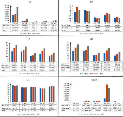
LSI, where larger values indicate more complex landscapes, was used to assess the complexity of vegetation patches across the habitat. The complexity of vegetation patches ranked as follows: cls103 (evergreen coniferous forest) > cls106 (shrubland) > cls105 (mixed coniferous-broadleaved forest) > cls102 (deciduous broad-leaved forest) > cls101 (evergreen broad-leaved forest). Within the protected areas, the complexity order was cls103 > cls106 > cls105 > cls101 > cls102, while outside the protected area it was cls103 > cls106 > cls105 > cls102 > cls101. This trend closely mirrored the PD trends. Specifically, for cls103, complexity outside the protected areas was greater than inside, indicating more complex patch shapes outside. Similarly, fragmentation was higher outside the protected areas for cls106 and cls101 compared to inside, and for cls105 and cls102 as well. Generally, higher PD indices corresponded to higher LSI values (Figure 6).
Overall, the fragmentation level of suitable habitat for Sichuan golden snub-nosed monkeys was examined. Evergreen coniferous forest had the largest area (CA = 83990.270) and the lowest fragmentation level (SPLIT = 265.810). However, it exhibited the highest LSI (LSI = 313.770) and PD (PD = 1.400), indicating a high density of patches with complex shapes. The highest fragmentation was observed in mixed coniferous-broadleaved forest (SPLIT = 1401977.200), followed by shrubland. Both within and outside the protected areas, the sizes and clustering of vegetation patches generally aligned (Figure 6). However, for deciduous broad-leaved forest, which is highly utilized by Sichuan golden snub-nosed monkeys, fragmentation within the protected areas was higher than outside.
3.3 Habitat Landscape Connectivity and Ecological Corridor Identification
3.3.1 Habitat Landscape Connectivity
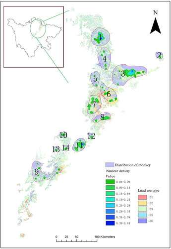
Through Kernel density analysis of Sichuan golden snub-nosed monkey distribution locations, we have identified that Sichuan golden snub-nosed monkeys were mainly distributed in 14 regions (Figure 7). The connectivity status of distribution areas of Sichuan golden snub-nosed monkeys and the importance values of each distribution area in maintaining connectivity were detailed in Table 3. The top five ranked areas in terms of distribution area connectivity probability (dPC value) were as follows: “3” located within Pingwu and Qingchuan (Tangjiahe); “9” located within Baoxing (Fengtongzhai), Lushan, Dayi; “1” located within Jiuzhaigou (Baihe Nature Reserve); “4” located within Pingwu (Wanglang), Jiuzhaigou (Wujiao); “8” located within Beichuan, An'xian and Maoxian.
| Distribution number | Detailed location | Value of dPC |
|---|---|---|
| 1 | Jiuzhaigou (Baihe Nature Reserve) | 22.468 |
| 2 | Qingchuan (Maozhai Nature Reserve) | 3.075 |
| 3 | Pingwu, Qingchuan (Tangjiahe) | 40.599 |
| 4 | Pingwu (Wanglang), Jiuzhaigou (Wanglang) | 18.372 |
| 5 | Pingwu (Xuebaoding Nature Reserve) | 8.298 |
| 6 | Pingwu, Beichuan (Piankou) | 0.000 |
| 7 | Beichuan, Maoxian (Xiaozhaizigou) | 0.000 |
| 8 | Beichuan, An'xian, Maoxian | 8.468 |
| 9 | Baoxing (Fengtongzhai), Lushan, Dayi | 24.140 |
| 10 | Lixian | 2.760 |
| 11 | Wenchuan, Dujiangyan, Penghzou (Longxihongkou) | 0.000 |
| 12 | Shifang(Jiudingshan) | 2.107 |
| 13 | Wenchuan (Wolong) | 1.464 |
| 14 | Wenchuan (Wolong) | 1.458 |
3.3.2 Ecological Corridor Identification
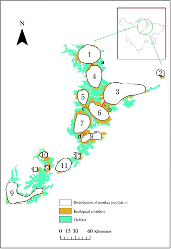
We identified the potential ecological corridors for Sichuan golden snub-nosed monkeys based on the Least-cost Distance Model, ensuring minimal cost paths through these ecological corridors (Figure 8). Unlike Euclidean distance, cost distance considers not only straight-line distance but also landscape features encountered along adjacent distribution zones. The ecological corridors identified incur the least cost for monkey migration across these “sources.” Four potential ecological corridors were identified (Figure): Corridor A connected distribution zones 1 and 4, passing through the Wujiao Nature Reserve; Corridor B linked zones 3 and 6; Corridor C connected zones 5 and 6, passing through the Xuebaoding Nature Reserve; Corridor D linked zones 7 and 8, traversing the Baodinggou Nature Reserve. Corridors A and D, located within protected areas, offer higher operational feasibility. Corridors B and c, linking zones 3, 5, and 6, hold significant conservation value. These four ecological corridors facilitate connectivity among northern distribution zones of Sichuan province for the Sichuan golden snub-nosed monkey.
4 Discussion
The Sichuan golden snub-nosed monkey was once widely distributed throughout China. Over the past two millennia, however, its population and range have sharply declined (Li, Pan, and Oxnard 2002; Jablonski 1998; Luo et al. 2015). Geographically isolated, the species now inhabits fragmented and limited areas (Li, Pan, and Oxnard 2002; Kirkpatrick and Grueter 2010), with populations having disappeared from southern and northeastern Sichuan Province, leaving a solitary population in a discrete region of Sichuan. Climate change and anthropogenic activities are considered the primary drivers of these changes Climate change represents a significant threat to global biodiversity (Garcia et al. 2014) and can affect species' geographical distributions (Brown et al. 2016), population dynamics (Townsend et al. 2016), phenology (Tomotani et al. 2016), biological interactions (Stenseth et al. 2015), and evolution (Waples and Audzijonyte 2016), as well as vegetation, food availability, nocturnal shelters, movement patterns, and changes in species distributions, including habitat contraction and expansion (Townsend et al. 2016; Brown et al. 2016). The impact of climate change on vegetation is expected to reduce the availability of suitable habitats (Xiang et al. 2011). The outcomes of climate change pose challenges to the conservation and persistence of many species (Gouveia et al. 2016), particularly those considered localized and at higher risk of extinction (Thomas et al. 2004). Our results indicated the significance of climate variables (b18, b2, b4) for suitable habitat suitability for the Sichuan golden snub-nosed monkey. Therefore, climate monitoring of its habitat is imperative.
Historically, the Sichuan golden snub-nosed monkey was commonly found in warmer, moister, and lower-altitude regions (Nüchel et al. 2018). Due to agricultural development and population growth in low-altitude areas, the species has gradually retreated to higher-altitude regions less accessible to humans (Nüchel et al. 2018). According to our research, anthropogenic disturbance variables (including dd, pop) are crucial environmental factors determining the suitability of habitats for the Sichuan golden snub-nosed monkey, highlighting the significant impact of human activities on habitat selection by this species. Therefore, it is essential to prioritize the conservation of their habitats to prevent anthropogenic disturbances such as livestock interference, construction activities, and infrastructure development, including power lines, roads, and railways. Although there have been numerous studies evaluating the habitats of the Sichuan golden snub-nosed monkey, most have focused on single protected areas. This study covers the entire Sichuan province as the research area, providing a broad macroscopic perspective on the current status of their habitats. The results of the MaxEnt model show a strong correspondence with the current actual distribution, indicating the reliability of the model results. While protected areas provide safeguards for biodiversity conservation, they do not always achieve the desired conservation outcomes (Rodrigues et al. 2004). We found that there are some suitable habitats in Liangshan, but our surveys did not detect any traces of the Sichuan golden snub-nosed monkey there. Liangshan historically served as a distribution area for the species as documented in historical records. The limited and geographically isolated suitable habitats in Liangshan are likely the main reasons for the disappearance of the Sichuan golden snub-nosed monkey in that region. Furthermore, for certain reserves, such as Jintangkongyu and Sandaogou, only suboptimal habitats are available, and they are distant from the suitable habitats. Fragmentation-induced heterogeneity may hinder migration if the distance between suitable patches exceeds the species' dispersal capabilities (Arnold et al. 1993).
According to our findings, the Sichuan golden snub-nosed monkey ranked its utilization of vegetation types from highest to lowest as deciduous broadleaf forests, evergreen coniferous forests, evergreen broadleaf forests, and mixed coniferous-broadleaf forests. These vegetation types are frequently utilized by the monkeys, with deciduous broadleaf forests being one of their active habitats throughout the year. This aligns with previous findings indicating the preference of Sichuan golden snub-nosed monkeys for deciduous broadleaf forests in the Qinling Mountains region (Li, Pan, and Oxnard 2002). It is noteworthy that further analysis of the fragmentation within suitable habitats reveals that the highest-density areas of Sichuan golden snub-nosed monkeys in deciduous broadleaf forests within protected areas exhibit higher fragmentation compared to those outside protected areas, possibly due to limited protection efforts for this forest type. This serves as a cautionary note for conservation management, emphasizing the need for focused conservation efforts on deciduous broadleaf forests. The most fragmented forest type is mixed coniferous-broadleaf forests, where encounters with Sichuan golden snub-nosed monkeys are frequent based on field surveys. Evergreen coniferous forests have the largest patch areas and the lowest fragmentation levels, but they possess multiple patches with complex shapes, posing risks of further fragmentation. Human activities or mismanagement of natural resources can lead to habitat fragmentation and isolation of natural populations (Thompson and Gergel 2008). Conservation practitioners should prioritize monitoring and conservation efforts across all vegetation types to protect habitats crucial for Sichuan golden snub-nosed monkeys.
Animal movement abilities can be altered by landscape fragmentation (Diffendorfer, Gaines, and Holt 1995). This alteration can have significant impacts on populations, partly due to reduced gene flow between populations, resulting in higher levels of inbreeding and loss of genetic diversity within fragments (Buchert et al. 1997). The exacerbation of habitat fragmentation often involves complex, long-lasting impacts on wildlife. This phenomenon typically reduces access to resources for wild animal populations, potentially confining them to isolated and more vulnerable habitat patches. As a result, population genetic diversity, growth rates, and sizes are adversely affected. Therefore, the degree of habitat fragmentation is often considered a key indicator in assessing the survival pressures of wildlife posed by transportation infrastructure. In our study, we conducted kernel density analysis of Sichuan golden snub-nosed monkey distribution points, identifying the primary distribution areas and determining that distribution zones numbered 3, 9, 1, 4, and 8 play critical roles in connectivity, exhibiting high connectivity. The areas with the least resistance during the Sichuan golden snub-nosed monkey migration are located within Pingwu County (between zones 3 and 6) and within the area marked as zone 11 in Dujiangyan. Other low-resistance areas are scattered, indicating severe limitations in the distribution of the Sichuan golden snub-nosed monkey and significant resistance during migration. This constraint could be a key factor contributing to the shrinking distribution of the species. Additionally, substantial overlap between the distribution areas of the Sichuan golden snub-nosed monkey and giant pandas might mean that habitat restoration measures designed primarily for pandas may not be entirely suitable for the needs of the Sichuan golden snub-nosed monkey.
Habitat fragmentation significantly impacts the survival of wildlife and is one of the primary threats to biodiversity, particularly evident for endangered species inhabiting montane regions (Xiao et al. 2003; Wang et al. 2023). Ecological corridors are frequently utilized to mitigate habitat fragmentation; however, the high costs associated with their construction and their often limited effectiveness in practice necessitate alternative strategies. In this regard, the stepping stone strategy (SSS) presents an effective approach to the conservation of primates (Wang et al. 2023). Building upon the SSS, we employed the Least-cost Distance Model to identify four ecological corridors for the Sichuan golden snub-nosed monkey, which can effectively connect most of the suitable habitats, facilitating efficient habitat utilization by the monkeys. The ecological corridors identified are as follows: Xuebaoding Nature Reserve connecting distribution zones 5 and 6; Baishuihe Nature Reserve connecting distribution zones 11 and 12; Caopo Nature Reserve connecting distribution zones 10 and 14; Wolong Nature Reserve connecting distribution zones 13 and 14; Jiudingshan Nature Reserve connecting distribution zones 8 and 12; Xiahegou Nature Reserve connecting distribution zones 3 and 4; Longdisi Nature Reserve connecting distribution zones 4 and 5; Baodinggou Nature Reserve connecting distribution zones 7 and 8; Baiyang Nature Reserve connecting distribution zones 5, 6, and 7; Wujiao Nature Reserve connecting distribution zones 1 and 4; Baodinggou and Jiudingshan Nature Reserves connecting distribution zones 7, 8, and 12. However, only the Wujiao Nature Reserve is suitable for constructing ecological corridors, as migration routes through other reserves would incur high costs. This suggests that most reserves have limited effectiveness in connecting Sichuan golden snub-nosed monkey distribution zones. Therefore, it is crucial for these reserves to collaborate and maximize their protective functions. Encouragingly, the establishment of the Giant Panda National Park with a unified and efficient management structure will effectively address deficiencies in cross-regional and cross-departmental conservation management systems.
5 Conclusions and Recommendations
Based on our field survey data and protected area records, our study systematically assessed the spatial heterogeneity and habitat quality of Sichuan golden snub-nosed monkey habitats in Sichuan Province using 3S technology and ecological models. We identified that the potential habitat area for the Sichuan golden snub-nosed monkey reaches 78,470.47 km², with suitable and marginally suitable habitats occupying 28,301.36 and 50,169.11 km², respectively. Suitable habitats are predominantly found at elevations between 1600 and 3200 m, in areas with low population density and minimal human disturbance. Furthermore, within natural reserves, suitable and marginally suitable habitats account for 42.7% and 24.8% of the total suitable and marginally suitable habitats, respectively. Our study also revealed that the Sichuan golden snub-nosed monkey primarily utilizes several vegetation types, including deciduous broadleaf forests, evergreen coniferous forests, evergreen broadleaf forests, mixed coniferous and broadleaf forests, and shrublands. Among these, evergreen coniferous forests have the largest patch area and the lowest degree of fragmentation, whereas deciduous broadleaf forests exhibit relatively higher fragmentation within protected areas. Finally, we identified four potential ecological corridors connecting Wujiao Nature Reserve, Xuebaoding Nature Reserve, and Baodinggou Nature Reserve.
To effectively protect the Sichuan golden snub-nosed monkey, we proposed the following specific conservation measures: (a) Ecological corridor development: Establishing ecological corridors is a priority to enhance connectivity among the monkey's distribution areas. This will improve habitat utilization and mitigate the effects of habitat fragmentation. (b) Tiered habitat protection: A tiered protection approach should be implemented to avoid a blanket protection strategy. Suitable habitats must receive strict protection, while marginally suitable habitats should undergo enhanced management to prevent further fragmentation. (c) Edge protection focus: Special attention should be given to suitable habitats and monkey populations located on the edges of protected areas, such as Jintangkongyu and Sandagu regions. Strengthening protection in these areas is essential. (d) Vegetation management: Vegetation in the Sichuan golden snub-nosed monkey habitats, particularly mixed coniferous and broadleaf forests and shrublands, should be prioritized to prevent fragmentation. In areas where suitable habitats are limited, relocation measures should be considered to improve the survival and reproductive conditions of the monkey population. (e) Human disturbance management: It is essential to balance development and conservation by controlling human disturbances and competition in the habitats. Effective strategies to minimize human impacts, such as limiting infrastructure development, should be implemented. (f) Climate monitoring: Climate monitoring of the monkey's habitats is necessary to ensure that environmental changes do not exacerbate the threats to their survival.
Author Contributions
Yunchuan Dai: writing–review and editing (lead). Yujing Zhu: writing–review and editing (equal). Wancai Xia: investigation (equal). Shuzhen Zou: investigation (equal). Fan Wang: investigation (equal). Dayong Li: conceptualization (lead), funding acquisition (lead), writing–review and editing (equal).
Acknowledgments
We express our gratitude to the nature reserves in Sichuan Province for their invaluable assistance with the ground surveys. This research was supported by the project of the National Natural Science Foundation of China (No. 32270548; 32200403), the Sichuan Science and Technology Program (23RKX0326), the Second Tibetan Plateau Scientific Expedition and Research Program (No. 2019QZKK0501), and Chongqing Social Science Planning Talent Program in 2022 (2022YC067).
Ethics Statement
The authors have nothing to report.
Conflicts of Interest
The authors declare no conflicts of interest.
Open Research
Data Availability Statement
The original contributions presented in the study are included in this paper. Further inquiries can be directed to the corresponding author.


