Modelling and Mapping Habitat Suitability for B. aegyptiaca (L.) Del. and B. rotundifolia (Tiegh.) Blatt. under Climate Change in Ethiopia
Abstract
Climate change impacts are posing greater risks to biodiversity, food security, and livelihood in Africa, specifically in arid and semi-arid environments. In Ethiopia, the genus Balanites Del., which belongs to the monogeneric family called Balanitaceae, has the multipurpose B. aegyptiaca and B. rotundifolia. However, these species are overlooked and endangered by climate change, and their species distributions are not well documented and understood in Ethiopia. Therefore, this study aimed to model the habitat suitability of these two species using current occurrence data, climate, and landscape data and predict their distribution under climate change. Occurrence points of B. aegyptiaca (n = 224) and B. rotundifolia (n = 80) were collected from field surveys and herbarium. Bioclimatic (WorldClim.v2), soil, and landscape variables were used in the ensemble species distribution models (SDMs) using six algorithms (GLM, GAM, BRT, RF, MARS, and SVM). The ensemble SDMs under the current climate showed that the Central Ethiopian Rift Valley is highly suitable habitats for B. aegyptiaca accounting for an area of 114,517 km2, and the Southern Ethiopian Rift Valley is highly suitable habitats for B. rotundifolia accounting for an area of 41,373 km2. The performance of ensemble SDM under the current climate for B. aegyptiaca showed 0.95 AUC, 0.80 TSS, 0.79 COR, and 0.87 deviance; and that of B. rotundifolia with 0.90 AUC, 0.80 TSS, 0.80 COR, and 0.50 deviance. Temperature annual range (Bio07) and precipitation seasonality (Bio15) for B. aegyptiaca; and precipitation of driest quarter (Bio17) and annual precipitation (Bio12) for B. rotundifolia are the most key bioclimatic variables that affect their distributions. The ensemble SDMs under SSP2-45 and SSP5-85 (HadGEM3-GC31-LL) climates showed that the highly suitable areas will remain suitable for both species (B. aegyptiaca with 116,934 km2 area cover (ΔA = +2.1%) and 125,757 km2 area cover (ΔA = +7.5%) and B. rotundifolia with 29,547 km2 area cover (ΔA = −28.6%) and 50, 894 km2 area cover (ΔA = +23%), respectively). The findings of this study implicated that the Ethiopian Rift Valley region in general for B. aegyptiaca and the Southern Rift Valley of Ethiopia for B. rotundifolia are suitable areas for conservation and sustainable use of the species.
1. Introduction
The main drivers of biodiversity loss include habitat loss and fragmentation, overharvesting, invasive alien species, and climate change [1, 2]. It is anticipated that in the 21st, century, climate change, characterized by an increasing atmospheric CO2 concentration, will pose a serious threat to the biodiversity, abundance, and distribution of most species [1–3]. The vulnerability of a species to effects of climate change depends on its exposure, sensitivity, and adaptive capacity [3]. For instance, a species with low sensitivity and high adaptive capacity (i.e., thermophilic species) is more likely to cope with climate change. On the other hand, a species with high sensitivity and low adaptive capacity is more likely to face the risk of extinction due to climate change [3]. Previous studies have indicated that prolonged habitat reduction resulting from climate change has significantly altered the structure and species composition of various ecosystems [4]. In this regard, endemic species with limited habitat ranges are prone and vulnerable to the changing climate [5, 6]. For that reason, it is predicted that over 5000 plant species in Africa will lose their ideal habitat ranges by 2085 [6, 7].
Dryland areas, especially semi-arid regions, have been expanding over past 60 years and are projected to continue expanding in the future [8–11]. Climate predictions suggest that both the warming temperature and drought frequency in drylands will increase at a faster rate than the global average [12]. The expansion of dryland ultimately decreases carbon sequestration and exacerbates local warming [11]. Thus, the effect of climate change on the drylands is posing greater risks to biodiversity, food security, and livelihoods in Africa [13, 14]. In this regard, Ethiopia is considered one of the most vulnerable countries in climate change [6, 15]. The majority of the Ethiopian landmass (ca. 70%) is arid and semi-arid, with erratic and low rainfall patterns [16], and bizarre biodiversity resources supporting large numbers of communities [17]. In recent years, dramatic climate change has been witnessed in Ethiopia, generally manifested by increasing temperatures and decreasing rainfall [18, 19]. Similarly, we expect that climate change will have an impact on the distribution and abundance of Balanites species in Ethiopia. Therefore, it is crucial to understand the distribution of Balanites in relation to the climate change in Ethiopia. This understanding will allow for appropriate actions to be taken towards the conservation and management of the species.
Balanites Del. is a genus in the family Balanitaceae that includes multipurpose species distributed in dryland ecosystems in Ethiopia mainly in arid and semiarid areas. Different species of Balanites were reported for their use as sources of medicine, wild edible fruit, and fuel wood, and so on [20]. Balanites aegyptiaca is a multibranched, spiny shrub or tree up to 10 m tall and distributed in a wide ecological range. It occurs in the altitudinal range from below 500 to 2,000 meters above sea level [21]. Balanites rotundifolia is multistemmed, spiny, evergreen shrub or small tree (2–5 m tall), drought resistant, and grows on a variety of soils. In tropical African countries, including Ethiopia, B. aegyptiaca and B. rotundifolia give crucial ecological services including firewood, charcoal, human and veterinary medicine, forage for animals including bees. It also gives ecological services such as shade and soil conservation [20, 21]. In Ethiopia, B. aegyptiaca is commonly used as a medicinal plant in the Ada’ar District of the Afar region [22] to treat wounds [23], as well as infant sickness, herpes zoster, blackleg, breast cancer, lung infection, mumps, dysentery, and other diseases [24]. In Ethiopia, B. rotundifolia is also reported to be used as a medicinal plant in the Ada’ar District of the Afar region [22] and to treat malaria [23]. Personal observation also proves that many fauna and primate species also feed on the fruits of B. aegyptiaca and B. rotundifolia. However, these important species are not well understood with regards to their habitat suitability in the interface of climate change in Ethiopia. Thus, apart from impacts of concurrent climate changes, the utilization of Balanites for multipurpose use could aggravate the pressure on the population of species across a wide range of ecological areas. In Ethiopia, no proper areas are designated to promote the plantation, cultivation and domestication, and conservation of Balanites. Hence, it is very essential to model the species distribution of Balanites using emerging mathematical algorithms. This will help in identifying the best suitable habitat (i.e., niche) for the species. Also, Balanites is considered one of the best candidate species in dryland forestry programs, and by identifying their suitable habitat, it is possible to delineate areas that are appropriate for conservation and promotion of dryland rehabilitation.
Species distribution models (SDMs) are used as a tool to better understand the occurrence, ecology, and vulnerabilities of species and environmental factors that are linked to species distribution [25–28]. SDMs are mathematical models that simulate species’ distributions in reference to observed environmental variables (e.g., climatic, landscape, soil, and so on) making spatial predictions of the species in a given time [29]. Species distribution models are classified into three main groups: profile models (e.g., Bioclim), statistical regression models (e.g., general linear model), and machine-learning models (e.g., random forest). Recently, SDMs are steadily employed in ecological studies, such as habitat suitability studies, and climate change impacts [30]. They are widely used methods to predict the spatial and temporal distribution based on species occurrences and environmental variables that limit species habitats [31]. SDMs have variable performances [32] so that selection and implementation of models require great care to avoid model uncertainty that could mislead policymakers [29]. Consequently, many studies used more than one model in comparison [32].
Despite having a wider distribution and much ecological and economic importance, however, the habitat suitability of B. aegyptiaca and B. rotundifolia under climate change in Ethiopia is not well known. In other words, the distribution and conservation status of B. aegyptiaca and B. rotundifolia is not well documented in Ethiopia. Hence, understanding the potential distributions of the species fosters the future conservation and sustainable uses of the species. The objectives of this study are (i) to model the current potential distributions of B. aegyptiaca and B. rotundifolia under the current climatic conditions, (ii) to predict the future potential distributions of these species using SSP2-45 and SSP5-85 scenarios for years 2061–2080, and (iii) to identify the major climatic variables determining their distributions. Therefore, it was hypothesized that B. aegyptiaca and B. rotundifolia would change their species distributions under the changing climate in Ethiopia. The findings of this study provide important information for policy makers and conservation firms regarding the potential distribution of Balanites in Ethiopia as the climate changes. Results of this study could also be valuable for other African and Middle Eastern countries where Balanites is commonly found.
2. Materials and Methods
2.1. Study Area
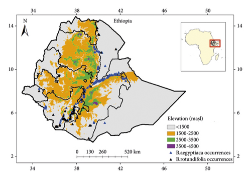
This study area is based on the arid and semi-arid ecosystems of Ethiopia, i.e., the Ethiopian Rift Valley, and the drylands of Northeastern, Northwestern, Northern, Southern, and Eastern Ethiopia (Figure 1). In other words, the study focuses on the arid and semi-arid ecosystems (up to 2,000 meters above sea level) that include the Vachellia-Commiphora woodland and bushland proper, Vachellia wooded grassland of the Ethiopian Rift Valley, and Combretum-Terminalia woodland wooded grassland ecosystems of Ethiopia [33]. However, this study ultimately aimed to produce model outputs for the whole country (i.e., Ethiopia) located between 3.3° to 14.9° North and 32.99° to 47.99° East.
2.2. Species Occurrence Data
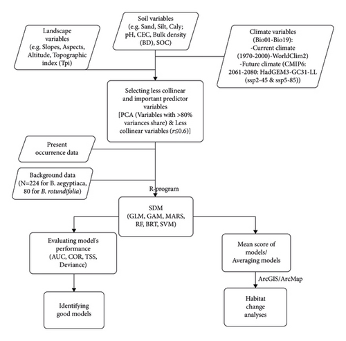
The current occurrence points of Balanites were collected mainly from field surveys and specimen records (1990s to present) of the National Herbarium of Ethiopia (ETH), Addis Ababa University. Therefore, a total of 224 and 80 occurrence points were gathered for B. aegyptiaca and B. rotundifolia, respectively. Occurrence points from fields were gathered randomly at a distance of 5–10 km, 50–100 m off the roadside, across the Ethiopian Rift Valley region and other dryland areas. The work of gathering occurrence points from the field was done in two phases: (i) between January 2019 and October 2020 (collection during this period was made by Dr. Tigist Wondimu for the purpose of phylogeography study by herself) and (ii) between January and June 2022. Moreover, background points for B. aegyptiaca (n = 224) and B. rotundifolia (n = 80) were generated at random points using occurrence data as domains in R4.1.3 (Figure 2).
2.3. Environmental Variables
The 30s resolution raster data of bioclimatic variables (i.e., Bio01–Bio19), elevation, solar radiation, and topographic index (all averaged for 1970–2000), and CMIP6’s future climate were downloaded from https://www.worldclim.com/version2, the Worldclim database [34], and downscaled to the study area (i.e., Ethiopia) using ArcGIS 10.8. Moreover, the data for soil variables at 30–60 cm rootable soil depth (e.g., clay, silt, and sand in g/100 g (%), and soil pH, cation exchange capacity (CEC) in cmol(c)/kg, soil organic carbon content (SOC) in g/kg, and bulk density (BD) in kg/dm3) from https://files.isric.org/soilgrids/latest/data_aggregated/1000m/ [35], and as well as landscape variables (e.g., aspects and slopes) from https://www.fao.org/soils-portal/data-hub/soil-maps-and-databases/harmonized-world-soil-database-v12/en/ [36] were downloaded and downscaled using ArcGIS 10.8 (Figure 2). All predictor variables were adjusted to have a similar spatial scale (i.e., 30 s resolution) and projection (i.e., GCS/WGS/1984). All predictor variables were adjusted to have a similar spatial scale (i.e., 30 s resolution). The Intergovernmental Panel on Climate Change (IPCC) equally treated all global climate models (GCMs) for their accuracy [37, 38]. However, for this study, therefore, one of the better-performing GCMs in Ethiopian environments [6, 39–41], namely, the third Hadley Centre Global Environmental Model run in the Global Coupled Configuration 3.1 (HadGEM3-GC31-LL), was downloaded and selected for the year 2061–2080 under SSP2-45 and SPP5-85 [42]. The SSPs are a new set of CO2 emission scenarios driven by different socioeconomic assumptions. The SSP2-45 and SSP5-85 projections represent global temperature anomalies of 2.4°C (or around 3°C) and 4.9°C above preindustrial levels by 2100 with atmospheric CO2 equivalents of 650 and 1370 ppm, respectively [43–45].
2.4. Collinearity Analysis of Environmental Variables
Collinearity among predictors decreases the efficiency and increases the uncertainty of species distribution models [46, 47]. Hence, it is very essential to partially exclude collinear and less important variables to increase efficiency and decrease the uncertainty of models’ projections. Therefore, following De Marco and Nóbrega [47] and Cruz-Cárdenas et al. [48], principle component analysis was computed for 42 environmental variables based on their correlation matrix. Then, using the first four principal components (PCA1‒4) that explained the largest proportions (>80%) of the total variance and less collinearity (r ≤ 0.6) most important variables influencing species distribution were finally selected (Figure 2). Finally, 14 and 13, the most important but less collinear variables, were selected to generate SDMs of B. aegyptiaca and B. rotundifolia, respectively (Table 1).
| B. aegyptiaca | B. rotundifolia | ||
|---|---|---|---|
| Variables | Descriptions | Variables | Descriptions |
| Bio07 | Temperature annual range (Bio5-Bio6) | Bio02 | Mean diurnal range (mean of monthly (max temp-min temp)) |
| Bio08 | Mean temperature of the wettest quarter | Bio12 | Annual precipitation |
| Bio14 | Precipitation of the driest month | Bio17 | Precipitation of the driest quarter |
| Bio15 | Precipitation seasonality (coefficient of variation) | AspectClS | Aspect: south: 135° < aspect ≤ 225° |
| Bio16 | Precipitation of the wettest quarter | AspectClW | Aspect: west: 225° < aspect ≤ 315° |
| Bio18 | Precipitation of the warmest quarter | CEC | Cation exchange capacity of the soil |
| Tpi | Topographic index | pH | pH |
| AspectClE | Aspect: east: 45° < aspect ≤ 135° | Silt | Proportion of silt particles (≥0.002 mm and ≤0.05 mm) |
| AspectClS | Aspect: south: 135° < aspect ≤ 225° | SlopesCl2 | 0.5% ≤ slope ≤ 2%) |
| AspectClU | Aspect: undefined: slope aspect undefined | SlopesCl3 | 2% ≤ slope ≤ 5% |
| AspectClW | Aspect: west: 225° < aspect ≤ 315° | SlopesCl4 | 5% ≤ slope ≤ 10% |
| Clay | Proportion of clay particles (<0.002 mm) in the fine earth fraction) | SlopesCl6 | 15% ≤ slope ≤ 30% |
| Silt | Proportion of silt particles (≥0.002 mm and ≤0.05 mm) | SlopesCl8 | Slope > 45% |
| SlopesCl4 | 5% ≤ slope ≤ 10% | ||
2.5. Extracting Values from Rasters, Model Fitting, and Prediction
The present background data records for the selected environmental predictor variables corresponding to the present occurrence and background points for B. aegyptiaca (n = 224) and B. rotundifolia (n = 80) were extracted and generated using the SDM package [49] with the support of other required packages such as Raster package [50]. The data model was partitioned into the training dataset (75%) and testing dataset (25%) for model fitting and validation, respectively. Hence, the training data was used to fit (or train) the models, and the testing data were used to evaluate (or test) the models [26]. The models were fitted to the data model using SDM and SP packages in R 4.1.3 [50–52] using the cross-validation partitioning method with 10 replication runs. The models were optimized with the same feature classes (fc = linear, quadratic, hinge, and product), regularization multiplier (reg = 1), and iterations (iter = 500) using the SDMtune package in R4.1.3 [53]. Therefore, two regression-based models, i.e., generalized linear model (GLM) and general additive model (GAM), and four machine learning modeling tools, such as boosted regression tree (BRT), random forests (RF), multivariate adaptive regression splines (MARS), and support vector machines (SVM) were used for both the current and future climates (HadGEM3-GC31-LL). Then, predictions using models for habitat suitability were done using the predictor variables and the models’ objects as domains (a combination of independent variables). Accordingly, the ensemble SDMs were computed from the weighted means of individual models under both current and future climates based on their performances. Future projections of species distribution were based on the premise that only climate variables would change while soil and topographical variables would remain unchanged. The SDMs were then converted to raster tiff files using the Raster packages in R 4.1.3 [50] for further analysis using ArcGIS 10.8. The relative importance of predictors in the ensemble models’ performance was also computed in R 4.1.3 based on Pearson correlation and AUC metrics for test data (averaged for 6 models after 10 permutations of each model). The relative variable importance measures either the percentage (not probability) that the prediction error increases when the variable is removed or the change in the purity of each node when the variable is removed.
2.6. Model Performance Evaluation
Four performance evaluation metrics, namely, area under curve (AUC), correlation (COR), true skill statistic (TSS), and deviance were used to evaluate the performance and validity of individual and ensemble SDMs. The AUC (which ranges from 0 to 1) is mainly used to determine the performance of models [26, 54]. It is simply the proportion of the true presence rate (sensitivity related to presence data) and the true absence rate (specificity related to absence data). AUC values ranging between 0.5 and 0.7 are considered weak models, values between 0.7 and 0.9 show good performance, and values greater than 0.9 indicate high model performance [26, 54]. TSS ranges between −1 and 1, where values below 0.4 and above 0.8 are considered “poor” and “excellent,” respectively [32, 54]. A correlation (COR) also has a value ranging from −1 to 1. Deviance is also one of a goodness-of-fit used, and so the lower the deviance, the better the goodness-of-fit of the model. Therefore, as a rule of thumb, a comparison of the accuracy of individual models was done by taking into consideration the overall performance of each model under each evaluation metric. The performances of ensemble SDMs were also evaluated based on their weighted mean scores (and standard deviations) under each evaluation metric. In addition, spatial autocorrelations among individual SDMs were also computed in R4.1.3.
2.7. ArcGIS Analysis of Habitat Suitability Classes
Moreover, based on the probability of occurrence, the ensemble SDMs were reclassified into four suitability classes following Hamid et al. [55]: (i) unsuitable (0.0–0.25), (ii) low-suitable (0.25–0.50), (iii) moderately suitable (0.50–0.75), and (iv) highly suitable (0.75–1.00). Hence, the change in the habitat area (ΔA) between current and CMIP6’s climate conditions was predicted using two indicators [56] using the formula: ΔA = ((Af − Ac)/Ac) ∗ 100; where ΔA is the percentage change of suitable habitat area; Af is the predicted area of suitable habitat for species of Balanites in the future, and Ac is the predicted area of suitable habitat under current conditions. Here, highly suitable, moderately suitable, low-suitable, and unsuitable areas were combined while calculating habitat area changes along the temporal scales of current and future climatic change.
3. Results
3.1. Model Performance and Spatial Autocorrelation under the Current Climate
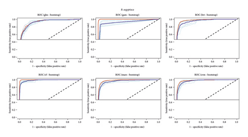
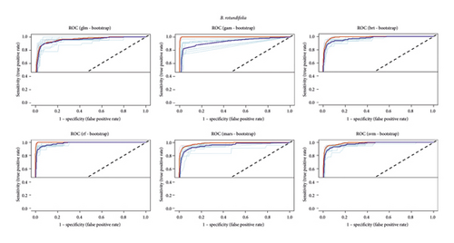
This study indicated that the random forest (RF) is the most robust model under both B. aegyptiaca (0.99 AUC, 0.91 TSS, 0.9 COR, and 0.23 deviance) and B. rotundifolia (0.97 AUC, 0.87 TSS, 0.84 COR, and 0.17 deviance), followed by SVM for B. aegyptiaca (0.97 AUC, 0.85 TSS, 0.82 COR, and 0.33 deviance) and B. rotundifolia (0.96 AUC, 0.85 TSS, COR = 0.77, and 0.21 deviance), and BRT for B. rotundifolia (0.96 AUC, 0.85 TSS, 0.79 COR, and 0.25 deviance) (Table 2). Under the current climate, analysis of the performance of ensemble SDM for B. aegyptiaca resulted 0.95 AUC, 0.80 TSS, 0.79 COR, and 0.87 Ddeviance; and that of B. rotundifolia with 0.90 AUC, 0.80 TSS, 0.80 COR, and 0.50 deviance (Table 2). Similarly, the receiver operating characteristic (ROC) curves of ensemble SDMs of each species under the current climate showed that the AUC for the training and testing data is generally above 0.85 (Figures 3 and 4).
| Species | Model | AUC | TSS | COR | Deviance |
|---|---|---|---|---|---|
| B. aegyptiaca | GLM | 0.93 | 0.70 | 0.68 | 0.53 |
| GAM | 0.92 | 0.83 | 0.8 | 3.14 | |
| BRT | 0.95 | 0.8 | 0.77 | 0.55 | |
| RF | 0.99 | 0.91 | 0.9 | 0.23 | |
| MARS | 0.96 | 0.82 | 0.8 | 0.42 | |
| SVM | 0.97 | 0.85 | 0.82 | 0.33 | |
| 0.95 ± 0.02 | 0.80 ± 0.06 | 0.79 ± 0.06 | 0.87 ± 1.02 | ||
| B. rotundifolia | GLM | 0.93 | 0.78 | 0.67 | 0.28 |
| GAM | 0.9 | 0.77 | 0.72 | 1.97 | |
| BRT | 0.96 | 0.85 | 0.79 | 0.25 | |
| RF | 0.97 | 0.87 | 0.84 | 0.17 | |
| MARS | 0.93 | 0.81 | 0.73 | 0.39 | |
| SVM | 0.96 | 0.85 | 0.77 | 0.21 | |
| 0.90 ± 0.2 | 0.80 ± 0.4 | 0.80 ± 0.6 | 0.50 ± 0.7 | ||
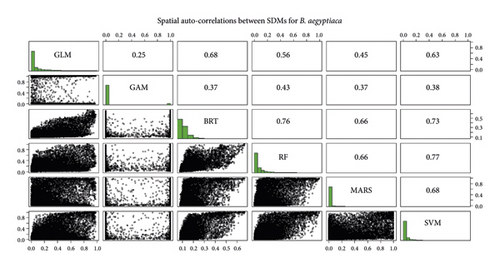
Spatial autocorrelations of models produced for B. aegyptiaca under the current climate (Figure 5) showed that the highest correlation was observed between RF and SVM (77%), followed by between BRT and RF (76%), BRT and SVM (73%), GLM and BRT (68%), RF and MARS (66%), BRT and MARS (66%), and GLM and SVM (63%). However, the lowest correlations were observed between GLM and GAM (25%).
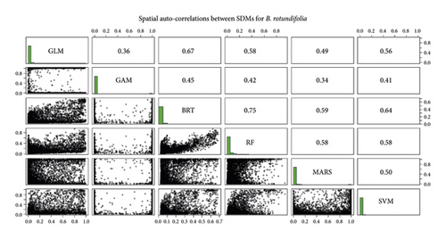
Similarly, for B. rotundifolia, the highest spatial autocorrelation among SDMs under the current climate (Figure 6) was observed between RF and BRT (75%), followed by between BRT and GLM (67%), BRT and SVM (64%), and BRT and MARS (59%). However, the lowest correlations were observed between MARS and GAM (34%), followed by GLM and GAM (36%).
3.2. Potential Distribution of Balanites aegyptiaca
The species distribution models (SDMs) computed under the current climate predicted that mainly the Ethiopian Rift Valley and a few dryland ecosystems of Ethiopia are the most suitable habitats for B. aegyptiaca. The ensemble SDM showed that the Central Ethiopian Rift Valley is the most suitable habitat area for B. aegyptiaca (Figure 7). Moreover, parts of Gambella, parts of Hararge, Bale, and Borena in Oromia, and parts of the Somali region are identified as low- to moderately-suitable habitats for the species.
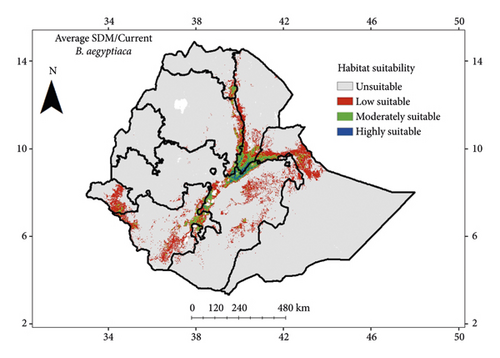
In this regard, the areas identified as unsuitable habitats for B. aegyptiaca accounted for 1,213,366 km2 area cover in Ethiopia, while 85,255 km2 is a low-suitable habitat, 24,424 km2 is a moderately suitable habitat, and 4,838 km2 is a highly suitable habitat (Table 3). Overall, the total area projected to be suitable for B. aegyptiaca under the current climate accounts for 114,517 km2 (Tables 3 and 4).
| Habitat suitability class | Areas in km2 | ||
|---|---|---|---|
| Current | SSP2-45 | SSP5-85 | |
| Highly suitable (HS) | 4,838 | 4,854 | 7,799 |
| Moderately suitable (MS) | 24,424 | 24,200 | 22,246 |
| Low suitable (LS) | 85,255 | 87,880 | 95,712 |
| Unsuitable | 1,213,366 | 1,210,949 | 1,202,126 |
| SSP | Not suitable (km2) | Estimated area (km2) of suitability = LS + MS + HS | Area changes (ΔA = ((Af − Ac)/Ac) ∗ 100) |
|---|---|---|---|
| SSP2-45 | 1,210,949 | 116,934 (Af) | +2.1%↑, increasing |
| SSP5-85 | 1,202,126 | 125,757 (Af) | +7.5%↑, increasing |
| Current average | 1,213,366 | 114,517 (Ac) |
Furthermore, analysis of the habitat suitability of B. aegyptiaca under SSP2-45 (HadGEM3-GC31-LL) showed that the Ethiopian Rift Valley region, East Oromia, Gambella, and North East Ethiopia will remain the suitable habitat for B. aegyptiaca (Figure 8). On the other hand, the ensemble SDM for B. aegyptiaca under SSP5-85 indicated that the Ethiopian Rift Valley region, East Oromia, and North and North East Ethiopia, and parts of the Somali region will remain suitable habitats for B. aegyptiaca (Figure 9).
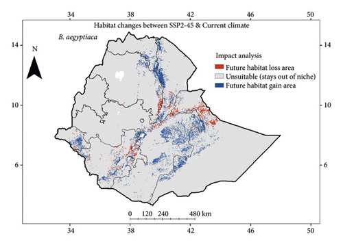
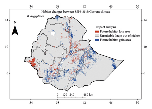
Therefore, analysis of the habitat area changes in habitat suitability indicated that 116,934 km2 and 125,757 km2 area cover in Ethiopia are predicted to be suitable for B. aegyptiaca under SSP2-45 and SSP5-85 in 2061–2080, respectively (Tables 3 and 4). In other words, analysis of the habitat changes between the current and future climate of HadGEM3-GC31-LL for years 2061–2080 showed that B. aegyptiaca will likely expand its habitat ranges by 2.1% and 7.5% of its current area under SSP2-45 and SSP5-85, respectively (Table 4).
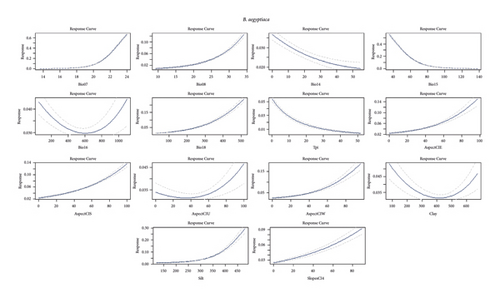
The relative importance of predictor variables averaged for all SDMs of B. aegyptiaca indicated that Bio07 (temperature annual range) is the most important variable with 53.1% contribution based on the correlation matrix and 29.4% contribution based on the AUC matrix for the “training data,” and 53.8% contribution based on the correlation matrix and 29.1% contribution based on the AUC matrix for the “testing data,” followed by Bio15 (precipitation seasonality) with 29.5% contribution based on the correlation matrix and 22.4% contribution based on the AUC matrix for the “training data,” and 34.3% contribution based on the correlation matrix and 22.6% contribution based on the AUC matrix for the “testing data.” In other words, the results showed that temperature and precipitation-related environmental variables were the ones that highly influenced the distribution of B. aegyptiaca (Table 5). However, it was observed that Bio07 is positively correlated (nonlinear) with the habitat suitability of B. aegyptiaca, while Bio15 is negatively correlated (nonlinear) with the habitat suitability of B. aegyptiaca (Figure 10).
| Variable | Relative variable importance (RVI) | |||
|---|---|---|---|---|
| Training data | Test data | |||
| Based on correlation matrix | Based on AUC matrix | Based on correlation matrix | Based on AUC matrix | |
| Bio07 | 53.1 | 29.4 | 53.8 | 29.1 |
| Bio08 | 1.8 | 0.8 | 1.7 | 0.7 |
| Bio14 | 0.3 | 0.1 | 0.3 | 0.1 |
| Bio15 | 29.5 | 22.4 | 34.3 | 22.6 |
| Bio16 | 0.6 | 0.4 | 0.7 | 0.1 |
| Bio18 | 3.8 | 1.9 | 3.6 | 3.7 |
| Tpi | 17.8 | 15 | 19.9 | 14.4 |
| AspectClE | 5 | 2.1 | 6.2 | 3 |
| AspectClS | 3.5 | 1.5 | 3.6 | 0.4 |
| AspectClU | 0.3 | 0.2 | 0.3 | 0.1 |
| AspectClW | 3.3 | 2 | 4 | 2.8 |
| Clay | 0.01 | 0.01 | 0.01 | 0.01 |
| Silt | 5.3 | 2.5 | 6.5 | 4.4 |
| SlopesCl4 | 1.8 | 0.6 | 2.1 | 0.7 |
3.3. Potential Distribution of Balanites rotundifolia
The projected SDMs for B. rotundifolia under the current climate indicated that the southern Ethiopian Rift Valley region, mainly South Omo, and areas of the Omo River watershed system are identified as the most important habitat areas for B. rotundifolia. Moreover, analysis of the ensemble SDM under the current climate showed that the southern Ethiopian Rift Valley regions, particularly the South Omo, are still the most suitable habitat for B. rotundifolia. Moreover, some arid and semi-arid areas of Gamo and Wolaita, Sidama and Guji areas, and a few areas of the northern Ethiopian Rift Valley (northern Afar region) are identified as low-suitable habitat areas for B. rotundifolia (Figure 11).
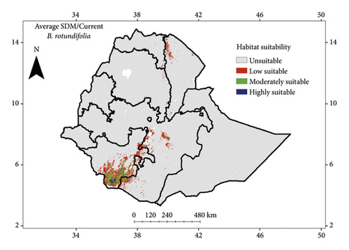
Moreover, under the current climate, the ensemble SDM estimated that unsuitable habitat for B. rotundifolia accounted for 1,286,510 km2 area cover in Ethiopia, while 29,689 km2 is low-suitable habitat, 9,683 km2 is moderately suitable habitat, and 2,001 km2 is highly suitable habitat (Table 6). Overall, the total area projected to be suitable for B. rotundifolia under the current climate accounts for 41,373 km2 (Tables 6 and 7).
| Habitat suitability class | Areas in km2 | ||
|---|---|---|---|
| Current | SSP2-45 | SSP5-85 | |
| Highly suitable (HS) | 2,001 | 2,574 | 4,181 |
| Moderately suitable (MS) | 9,683 | 5,120 | 13,126 |
| Low suitable (LS) | 29,689 | 21,853 | 33,587 |
| Unsuitable | 1,286,510 | 1,298,336 | 1,276,989 |
| SSP | Not suitable (km2) | Estimated area (km2) of suitability = LS + MS + HS | Area changes (ΔA = ((Af − Ac)/Ac) ∗ 100) |
|---|---|---|---|
| SSP2-45 | 1,298,336 | 29,547 (Af) | ‒28.6%↓, decreasing |
| SSP5-85 | 1,276,989 | 50,894 (Af) | +23.0%↑, increasing |
| Current average | 1,286,510 | 41,373 (Ac) |
The projected SDMs for B. rotundifolia under SSP2-45 of the HadGEM3-GC31-LL climate model indicate that the Southern Ethiopian Rift Valley regions, particularly the South Omo and South Oromia, will remain suitable for the species in years between 2061 and 2080. Except some area shifting, under both SSP2-45 and SSP5-85, the ensemble SDMs showed that the Southern Ethiopian Rift Valley, mainly the South Omo region, and North eastern Ethiopia, will remain the most suitable habitat for B. rotundifolia in years 2061–2080 (Figures 12 and 13).
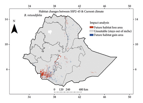
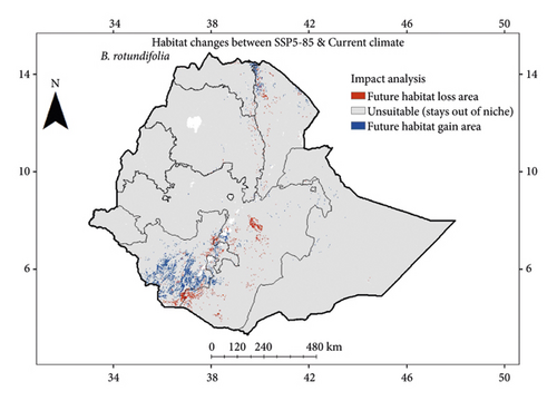
Furthermore, analysis of the area changes in habitat suitability indicated that 29,547 km2 and 50,894 km2 area cover in Ethiopia are predicted to be suitable for B. rotundifolia under SSP2-45 and SSP5-85 in 2061–2080, respectively (Tables 6 and 7). In other words, analysis of the habitat changes between the current and future climate of HadGEM3-GC31-LL for years 2061–2080 showed that B. rotundifolia will likely decrease its habitat range by 28.6% (↓) under SSP2-45 and increase by 23% (↑) of its current area under SSP5-85 (Table 7).
Analysis of the relative contributions of predictor variables averaged for all SDMs for B. rotundifolia showed that Bio17 (precipitation of the driest quarter) is highly contributing to the models’ performance of B. rotundifolia, accounting for 79.6% and 40.6% based on correlation and AUC matrices for the “training data,” respectively, and 82.3% and 42.5% based on correlation and AUC matrices for the “testing data,” respectively, followed by Bio12 (Annual Precipitation) with 64.8% and 36.2% contribution based on correlation and AUC matrices for the “training data,” respectively, and 61.4% and 29.3% contribution based on correlation and AUC matrices for the “testing data,” respectively (Table 8).
| Variable | Relative variable importance (RVI) | |||
|---|---|---|---|---|
| Training data | Test data | |||
| Based on correlation matrix | Based on AUC matrix | Based on correlation matrix | Based on AUC matrix | |
| Bio02 | 15.7 | 6 | 11.8 | 0.01 |
| Bio12 | 64.8 | 36.2 | 61.4 | 29.3 |
| Bio17 | 79.6 | 40.6 | 82.3 | 42.5 |
| AspectClS | 0.01 | 0.01 | 0.01 | 0.01 |
| AspectClW | 0.1 | 0.1 | 0.1 | 0.01 |
| CEC | 27.9 | 8.4 | 20 | 2.4 |
| pH | 8.6 | 2.7 | 6.7 | 2.4 |
| Silt | 0.01 | 0.01 | 0.01 | 0.2 |
| SlopesCl2 | 1.5 | 0.4 | 1.2 | 0.3 |
| SlopesCl3 | 15.3 | 4.3 | 10.9 | 0.6 |
| SlopesCl4 | 2.1 | 0.7 | 0.2 | 0.01 |
| SlopesCl6 | 2.1 | 0.6 | 1.6 | 0.7 |
| SlopesCl8 | 5.1 | 6.6 | 4.3 | 0.7 |
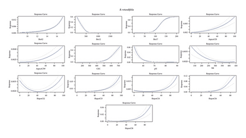
However, it was observed that Bio17 is positively correlated (nonlinear) with the habitat suitability of B. rotundifolia, while Bio12 is negatively correlated (nonlinear) with the habitat suitability of B. rotundifolia (Figure 14).
4. Discussion
4.1. Habitat Suitability of Balanites aegyptiaca under Climate Change in Ethiopia
In the present study, the performance evaluation tools such as AUC, TSS, COR, deviance as well as the receiver operating characteristic (ROC) curves (AUC > 0.85) calculated to the ensemble SDMs indicate that models are accurate in simulating the habitat suitability of B. aegyptiaca. Under the current climate, the ensemble SDM predicted that 114,517 km2 of the total area of Ethiopia mainly distributed in the Ethiopian Rift Valley and a few areas of Gambella, Hararge, Bale, and Borena in Oromia and Somalia regions are identified as potential suitable habitats for B. aegyptiaca. This finding partly agreed with the preliminary modeling reported by Kindt et al. [57] on the habitat distribution of B. aegyptiaca in Ethiopia inferred from the ensemble modeling with BiodiversityR. Similarly, Bekele-Tesemma [58] also reported that in Ethiopia, B. aegyptiaca normally occurs up to 1,800 m altitude in the arid and semi-arid agroclimatic zones of the Rift Valley in Gamo, Gofa, and in Sidama, Tigray, Wollo, Shewa, Gojam, Ilu Ababora, Arsi, and upland Hararge regions. These suitable areas will remain suitable in the future under both SSP2-45 and SSP5-85 of HadGEM3-GC31-LL with increasing areas to 116,934 km2 and 125,757 km2 of Ethiopia in 2061–2080, respectively. A recent projection of the maximum entropy distribution of B. aegyptiaca for Tigray region of Ethiopia by Gufi et al. [59] showed that the habitat suitability of the species will increase by 2070 under RCP4.5 scenarios, while decreasing in mid- and end-century under RCP8.5. A study by Chérif et al. [60] also indicated that B. aegyptiaca may decrease its habitat suitability by 2055 but a significant habitat increase by 2085 beyond its current habitat in the Republic of Chad under CMIP5’s RCP8.5 emission scenario. The increasing in habitat suitability for B. aegyptiaca is possibly due its morphological and physiological responses and adaptive strategies to cope with drought and increasing temperature, including a significant reduction of biomass, early stomatal closure with small changes in photosynthesis activities [61].
The temperature annual range (Bio07) and precipitation seasonality (Bio15) are the most important variables influencing the distribution of B. aegyptiaca in Ethiopia. A recent projection of the maximum entropy distribution of B. aegyptiaca for Tigray region of Ethiopia (i.e., untruncated niche) by Gufi et al. [59] showed that temperature seasonality (Bio04), mean diurnal range (Bio02), and temperature annual range (Bio07) are reported as most important variables determining the distribution of the species. However, for species with wider global distribution (e.g., B. aegyptiaca), species distribution models of truncated niche, i.e., models based on data pools from wider geographical areas such as regional or global, are more accurate than models of untruncated niche, i.e., models based on data from restricted geographical ranges [62]. Another study of the maximum entropy of B. aegyptiaca by Chérif et al. [60] for the republic of Chad under the changing climate using CMIP5’s RCP8.5 indicated that precipitation of the wettest month (Bio13) was the most important variable in model predictions. This showed that variable selection and ensemble models’ approach are very essential in the model calculation to increase model accuracy. In this regard, De Marco and Nóbrega [47] advised that PCA-derived variable selection was an effective approach for species modeling both to control negative effects of collinearity and as a more objective solution for the problem of variable selection. In this sense, the current study had the merit of proper variable selection for the modeling purpose of the subject species. Moreover, in addition to bioclimatic variables, incorporating soil and landscape parameters would also result in different but more sounding models, as these variables are determinant factors for plant growth and geographical distribution [63, 64]. A report by Orwa et al. [21] also indicated that the ecosystem of B. aegyptiaca is predominantly characterized by soil particles of deep sands, sandy clay, loam, sandy loam, or clay with a physical limit of 0–2000 m altitude, 20–30°C mean annual temperature, and 250–1200 mm mean annual rainfall.
4.2. Habitat Suitability of Balanites rotundifolia under Climate Change in Ethiopia
The performance evaluation tools such as AUC, TSS, COR, deviance as well as the receiver operating characteristic (ROC) curves (AUC > 0.85) calculated to the ensemble SDMs indicate that models are accurate in simulating the habitat suitability of B. rotundifolia. The ensemble SDM for B. rotundifolia under the current climate indicated that 41,373 km2 of the total area of Ethiopia is a suitable habitat for B. rotundifolia and distributed mainly in the Southern Ethiopian Rift Valley region. These areas will remain suitable in the future under both SSP2-45 and SSP5-85 of HadGEM3-GC31-LL with decreasing areas to 29,547 km2, and increasing to 50,894 km2 of Ethiopia in 2061–2080, respectively. This indicates that the high emission scenario (i.e., SSP5-85) likely helps B. rotundifolia to slightly increase its habitat ranges compared to its current ranges. Unlike B. aegyptiaca, te lower AUC values resulted for SDMs of B. rotundifolia could be influenced by smaller sample size of occurrences of B. rotundifolia. Nevertheless, B. rotundifolia has a restricted distribution in Ethiopia that was also proved by the SDM as well as personal field observations. In this regard, the actual field survey also proved the presence of a higher density of the population of B. rotundifolia across the designated areas than any other areas surveyed in the study area. Previously, no studies were reported that dealt with the habitat suitability of B. rotundifolia in Ethiopia. Hence, no credible findings were available that could be validated with the current study. Therefore, the current study could be taken as a breakthrough in habitat modeling for B. rotundifolia in Ethiopia and even be inferred to further habitat modeling of the species in other countries or on a global scale. Nevertheless, this study indicated suitable areas that should be strategically delineated for the conservation and management of the species for sustainable use.
In this study, precipitation of the driest quarter (Bio17) and annual precipitation (Bio12) share the largest contribution to the model’s prediction for B. rotundifolia. In other words, the distribution of B. rotundifolia was mainly influenced by both precipitation and temperature-related environmental variables and by CEC to some extent. In Kenya, B. rotundifolia was also reported to be often seen as the only tree on dunes in northern Kenya and observed between 50 m and 1350 m altitude and a 150 mm to 400 mm rainfall range [65, 66]. In Uganda, B. rotundifolia was reported to grow on a variety of soils, often found in sandy, dry river beds, as well as frequently occurring in very dry savannah [66].
Overall, this study presents valuable information on the distribution of Balanites species in Ethiopia in the context of climate change. The findings can be utilized by policy makers and conservation organizations to inform the development and implementation of conservation plans for Balanites species in the country. In addition, the study’s outputs can serve as crucial inputs for the scientific community, particularly those interested in conducting further research on various aspects of Balanites. However, it is important to note that this study has few potential limitations. For example, (i) with the uncertain nature of absence data and its importance in SDM [67], this research did not incorporate absence data as an additional input variable; (ii) this research, despite being the first SDM for B. rotundifolia, used a smaller sample size of occurrence data to model the habitat suitability for B. rotundifolia due to its rarity; (iii) this study was conducted using only one global climate model (GCM), and thus needs further research studies by incorporating other GCMs such as the second generation Euro-Mediterranean Centre on Climate Change Earth System Model (CMCC-ESM2) and the Goddard Institute for Space Studies Model version E2.1-H (GISS-E2-1-H) (NASA-GISS) that are also thought to have good performance in Ethiopian environments [6, 39–41]. Modeling the habitat suitability of Balanites based on a broadly truncated niche at a regional scale (e.g., East Africa) is recommended for the period between 2081 and 2100 besides the use of these research findings for decision-making and policy development.
5. Conclusions
The current study on modeling the habitat suitability for B. aegyptiaca and B. rotundifolia under climate change in Ethiopia has yielded significant results. These findings highlight potential habitat areas that should be given priority for the long-term conservation and sustainable utilization of each species in Ethiopia. Generally, the Ethiopian Rift Valley region and the dryland ecosystems in the broader areas of the country, including arid and semi-arid regions, are considered suitable for B. aegyptiaca and B. rotundifolia. Their distribution is highly influenced by temperature and precipitation-related environmental variables (Bio07 and Bio15 for B. aegyptiaca, and Bio17 and Bio12 for B. rotundifolia). It was also noticed that B. aegyptiaca tends to increase its habitat ranges under both future-forcing scenarios (SSP2-45 and 5–85). However, it is observed that B. rotundifolia tends to have two future possibilities, i.e., decreasing its habitat ranges under SSP2-45 and increasing under SSP5-85. Therefore, the current trends of land use and land cover changes, coupled with worsening effects of climate change, would potentially depopulate the species, especially that of B. rotundifolia. Hence, developing management strategies for protecting and conserving wild populations of this valuable species is crucial. In other words, conservation efforts should focus on maintaining large populations to counter potential negative effects of climate change and to promote and maintain the genetic diversity and viable populations of Balanites in Ethiopia.
Conflicts of Interest
The authors declare that they have no conflicts of interest.
Acknowledgments
We are very much grateful to the Vice President for the Research and Technology Transfer and the Research Director of Addis Ababa University for financial support through thematic research (AAU, TR 18-Round 9), run by Dr. Tigist Wondimu as the principle investigator. The Department of Plant Biology and Biodiversity Management (DPBBM) of AAU is also acknowledged for providing additional financial support to conduct the project.
Open Research
Data Availability
The data used to support the findings of this study are available from the corresponding author upon request.


