Design and Analysis of Remote Tourism Teaching and Training System Based on Adaptive Virtual Queue Algorithm
Abstract
In the traditional tourism teaching mode, the teaching activities between teachers and students are restricted by the teaching mode and teaching methods. This model fails to use efficient methods to improve students' learning ability, and students cannot communicate after class to improve their ability. Therefore, the adaptive virtual queue algorithm is introduced in the design of the remote tourism teaching and training system. During the design of the remote tourism teaching and training system, the adaptive virtual queue algorithm can be used to collect business data information with network technology and sensors and other equipment. The data information is stored in the constructed remote tourism teaching and training system. Finally, the experimental results show that the remote tourism teaching training system designed in this article can effectively improve students' learning efficiency by 95%, which effectively verifies that the training system can effectively improve the students' ability of independent learning and extracurricular communication through the use of this training system.
1. Introduction
The significance of the current tourism interactive model is promoted to the development of information services and work in the cultural tourism industry, to increase feasibility based on mobile, and sublimate its tourism cultural emotions to gain the resonance of tourists, and display its cultural tourism experience service mode, which is useful for supplementing the vacancy of intelligent facilities in the scenic area, and improve the propaganda on tourism culture, which provides new ideas and development directions for the development of regional cultural tourism services. The service information of tourist attractions is presented to tourists in a simple, easy-to-understand, and intuitive form, which can achieve visualization in the development of tourism service information, while improving the management and convenience of tourism services. By adopting the calculation method of the adaptive virtual queue algorithm, the best analysis method and the measurement method of the management capacity of the scenic spot, a tourism information training system is created to achieve more intelligent and personalized performance of travel information sharing in intelligent search, online scenic spot experience, online ticket purchase, and guiding view of panoramic scenic spot, the best travel route, as well as classic tour guides. In this context, in-depth study of the actual training system's structural design, calculation methods, and implementation process are performed [1, 2].
Through the in-depth analysis of virtual reality technology, this article proposes a virtual tourism teaching platform based on the virtual augmented reality algorithm. The system has the advantages of real time and portability, and can be used outdoors. It is a virtual tourism system that can meet the market demand and be widely used by the public. Finally, the virtual reality combination module is realized to meet the portability requirements of an outdoor virtual tourism system. In this study, the system is designed and developed by using the database. Experiments show that the system can be successfully implemented with the support of the above algorithms, with good real-time performance, and can achieve the expected augmented reality effect. This platform allows users to visit famous scenic spots all over the world without going out, so that users can enjoy the fun of playing in the virtual world. Based on this technology, the system can be used to restore some damaged scenic spots in the virtual environment. You can experience the historical and cultural landscape that people have never seen before.
2. Long-Distance Tourism and Related Algorithm Analysis
The virtual travel education model is an all-round experience system. The construction layer of the cloud training system and the application of the training system are linked to increase the value of scientific and technological innovation for the industry support, and the value of economic contribution enhances remote tourism teaching, and realize the new model of scientific decision-making and scientific education consolidation of travel education. This mode can dynamically access various application terminals and sensing nodes, and integrate various training system systems, including basic application training systems such as scenic spot smart marketing, smart guide, transaction settlement, scenic spot guidance and teaching, and tourist attraction information resource teaching. Meanwhile, it provides background support for the tourism industry and enterprises to open business and value-added application training systems. The so-called omnidirectional experience system of remote tourism is based on the adaptive virtual queue algorithm, using experience technology with the help of the Internet, and constructing an omnidirectional experience system of virtual tourism teaching mode according to the specific application requirements of various attractions, such as sensor technology and communication technology [3, 4]. Information can be selected starting from the destination, travel plans, hotels, restaurants, entertainment, and other consumption training system, which the all-round experience system can obtain and collect. Only valuable traveler information can be obtained through travel. Teaching, only automatic collection, monitoring, automatic classification, summarizing the tourist's travel situation, and timely grasp of the virtual travel experience database can effectively establish the cornerstone of remote travel.
The main part of the calculation method of the adaptive virtual queue algorithm is the calculation of the cloud training system. The use of experience, information dissemination, and central titles based on various training systems can greatly reduce computing costs and improve work efficiency. Cloud computing can calculate a regrettable result and carry more forms of data. These data can be used as information for virtual augmented reality calculations. Meanwhile, it effectively participates in the operation and calculation of the virtual augmented reality computing method and shares resources. Allow visitors to know the information they want anytime and anywhere. The meaning of the virtual augmented reality calculation method is through the reasonable use of the training system. The training system of virtual travel is constructed by using the education and training system of various travel companies, the teaching and training system of travelers, and the intelligent training system of communication tools. The cloud training system uses sensor information for work, sorting, classification, and development, providing the entire tourism industry and tourism departments with beneficial and effective scientific data resources, and creating an information-based training system and be able to plan education in a unified way for the tourism industry. The application training system can be planned into different modes, such as the government form that provides information to the government. A form of business that provides business information to tourism companies. Provide tourists with a tourist pattern full of effective and useful information. Long-distance tourism is universal, which can promote the development of tourism enterprises and bring greater space for their economic benefits.
Here, represents the shortest path between Vi and Vj within the system obtained after m iterations, and d represents the straight-line distance between Vi and Vj. If there is no arc between the two points, then the distance d between the two points is 0. If there are more than n fixed points between the systems, then the n-1 calculations need to be completed in system path selection to calculate the optimal and shortest path of the system path.
- (1)
Establish an initial distance matrix D(0) and set
(2) - (2)
Construct an iterative matrix D(k) and set
(3) - (3)
If D(k + 1) = D(k), then the iteration is terminated; otherwise, return to (3) to continue the operation.
-
In the above steps, in formula (2),
(4) - (4)
Where, .
However, in the process of performing the above calculations, it was found that the calculation efficiency was low and there was a large repetitive calculation process. For example, calculate the shortest distance between any two nodes Vi and Vj by adding n times each time. The efficiency is relatively low. Therefore, it is necessary to improve and optimize the adaptive virtual queue algorithm to select the best path of virtual travel that is more convenient and effective.
Here a is the model optimization criterion parameter and p is the distance parameter. In the case of a = 1 and p = 1, the above formula is a fuzzy comprehensive recognition model. In the case of a = 1 and p = 2, the above formula is an ideal point model. In the case of a = 2 and p = 1, the above formula is a sigmoid function. In the case of a = 2, p = 2, the above formula is the optimal model of ambiguity.
2.1. Best Path Algorithm
- (1)
Suppose that the weighted adjacency matrix edges are used to represent the weighted directed graph, and the weight on 〈vi, vj〉 can be represented by edges[i][j]. If 〈vi, vj〉 does not exist, edges[i][j] is set to ∞. The set S is all the best destinations that have been found starting from v (the source point).
-
The initial state is an empty packet. Then, the initial value of the optimal path length from v to other vertices (end points) vi in the graph may be as follows.
-
The position of the starting point V in the figure is represented by Locate Vex(G, v).
- (2)
Select Vj so that
(7) -
Vj What we want now is the best destination starting from v. Let S=SU(j).
- (3)
Change the optimal length of any vertex Vk from V to V-S. If
(8) -
Then D[k] is amended as
(9) - (4)
Repeat (2) and (3) for a total of n − 1 times, and optimize from v to the remaining vertices in the graph according to the increasing order of the optimal length.
When n vertices are located in the graph, when calculating the optimal problem from the source point to the remaining vertices in the graph, the time complexity of the adaptive virtual queue algorithm is O(n2), and the space complexity is Ω(n2).
2.2. Training System Architecture
- (1)
Area Capacity Method. According to the total area, sightseeing area, design, and other conditions of the scenic spot, the hospitality capacity and saturation of the scenic spot are calculated during the same period by means of the calculation method of area capacity. It is a method of making extensive use of sightseeing spots and spots where tourists stay for a long time. The calculation formula is as follows:
-
Instantaneous space capacity:
(10) -
Here V is the reception capacity or saturation of the scenic spot per unit time. A is the sightseeing area (unit: m2) and a is the activity area required by each tourist (unit: m2/person).
-
Daily space capacity:
(11) -
Here C is the environmental quality of Japan (the daily reception capacity or saturation of the scenic spot, the unit is the number of people), a is the tourism activity area (unit: m2) required by each tourist (unit: m2/person), and D is the turnover rate, D = opening time of scenic spot T/time t required by scenic spot.
- (2)
Line Capacity Method. According to the length of the trail provided to tourists in the scenic spot and the length of the trail occupied by a tourist alone, the number of tourists that can be received by the scenic spot at the same time is calculated. This method is suitable for major tourist attractions. The calculation formula is as follows:
-
Complete trail method:
(12) -
Incomplete trail method:
(13) -
Here C is the environmental quality of Japan (daily reception capacity or saturation of scenic spot, unit extension number of people), M is the total length of the trail (unit: m), m is the reasonable length of the trail per tourist (unit: m/person), and E is the incomplete trail. The required time F is the time that the trail is not fully completed and D is the turnover rate, D = the opening time of scenic area T/the required time t of the scenic spot.
- (3)
Bayonet Capacity Method. The volume of the mouth is also called the bottleneck volume. In scenic spot, tourism, landscape, play, and other elements constitute the activities of tourists. The hot spot becomes the bottleneck full of the crowd. In addition, due to the fragility of the environment and resources, improper control of tourist flow will cause environmental damage to the entire tourist destination.
Here V Garden Rock can receive the total number of tourists per day, T is the opening time of the gardens and rock cavity every day, and t is the time required by the two groups of tourists entering the garden and the solution cavity.
Here V is the number of tourists received by the river for sightseeing, it is the tour of the entire river surface, J is the distance between the two cabin cruisers that start successively, S is the number of passengers on all cabin cruisers, and n is the number of ships sailing each time.
According to the design ideas of the remote tourism teaching and training system, the network structure of Figure 1 is used to calculate the application mode of the system.
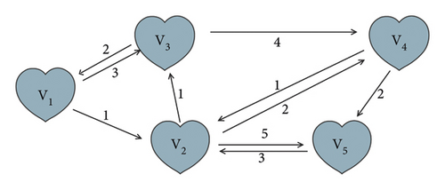
According to Figure 1, it is found that the optical spot network structure simulation system is a network structure that does not include negative circuits, and the steps for calculating the best path using the abovementioned improved optimized adaptive virtual queue algorithm are as follows:
From this, the values of other elements in D(1) and A(1) can be obtained, respectively, and then D(1) and A(1) can be obtained:
, then D(2) ≠ D(1).
At this time, , namely D(3) = D(2), the calculation is terminated at this time. It is obtained: the value of is the shortest path between the corresponding element node Vi and Vj, and is the shortest path between the corresponding node Vi and Vj. For example, to query the shortest path length and the shortest path between node Vi and Vj, the system can obtain the shortest path length between node Vi and node Vj as 5 according to the above calculation steps, and the shortest path is V1⟶V2⟶V4⟶V5. After obtaining this result, the remote tourism teaching and training system can be visually presented to tourists on the map, and tourists can arrange virtual journeys according to their actual needs.
Signal analysis algorithms can be divided into two categories, namely, gray-based signal analysis methods and feature-based signal analysis methods. However, compared with the gray-based signal analysis method, the feature-based signal analysis method has excellent matching performance and has a lower calculation amount and good stability, so it has become a popular research direction of domestic and foreign scholars and scientific research institutions. Image features are mainly divided into global features and local features. Compared with the global feature, the local feature is the feature extracted from the image locally, which is insensitive to the change of the scale, direction, and perspective of the image, and has good robustness. However, in the signal analysis method that this article focuses on and in the process of identifying outdoor scenes, there is a lot of external interference, including viewing angle changes, occlusion, and illumination. Therefore, this article chooses the signal analysis method based on local features.
3. Design of Remote Tourism Teaching and Training System Based on Adaptive Virtual Queue Algorithm
3.1. Training System Hardware Design
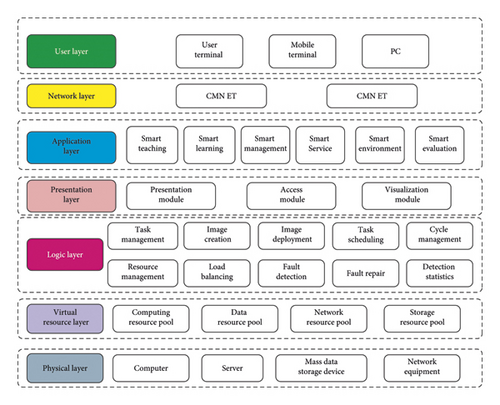
The virtual travel teaching and training system structure based on the adaptive virtual queue algorithm is divided into seven layers: physical layer, virtual resource layer, logic layer, presentation layer, application layer, network layer, and user layer. Its detailed configuration is shown in Figure 2.
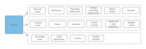
(1) The Hardware Equipment Configuration Structure Design of the Training System. Figure 3 shows the hardware device configuration in the virtual travel teaching and training system based on the adaptive virtual queue algorithm. It mainly includes a server, a switch, a firewall, a network cabinet, a camera, an audio and video splitter and a handwriting screen, and two computers [5]. Among them, the switch can set up switch equipment according to the number of online mergers of students. Considering the redundancy, an additional backup firewall is set up and a VPN firewall with redundant interfaces is adopted. Ensure the maximum number of combined operations of the entire remote tourism teaching and training system. The video, audio, and video VAmmc5 distributor mainly records the teacher's lesson, and records the audio and video on the control terminal. The teacher uses the handwritten screen to simulate the input of the blackboard on the screen [6].
(2) Design of Adaptive Virtual Queue Algorithm Center Module. The adaptive virtual queue algorithm center module is a data-intensive place for the business modules in the remote tourism teaching and training system based on the adaptive virtual queue algorithm. It mainly collects all business data through the network or sensors and other equipment, and saves it in a large-capacity data storage device. After processing it by using the data screen to process and clean technology, they are sent to the corresponding application for program operation.
3.2. Training System Software Design
3.3. Functional Design
The adaptive virtual queue algorithm and multimedia technology all use ResNet as the feature extractor of remote tourism teaching. The Reset SE Block module is introduced on the basis of the intelligent teaching method to construct the intelligent teaching method t network architecture in this article, as shown in Figure 4.
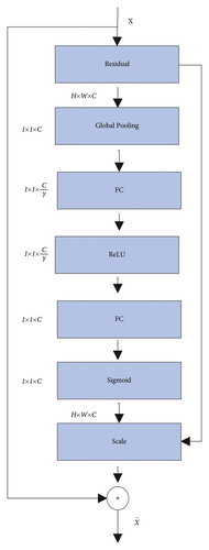
Here xi represents the feature of the image of the effectiveness of ith remote tourism teaching; yi represents the true category label corresponding to the image of the effectiveness of ith remote tourism teaching; Wj represents the weight of the category; bj represents the error value of the category; and m and n represent the number of training samples and the number of categories in turn. fj indicates the inner product relationship between the category weight Wj and the bias value bj in the fully connected layer in the active state: . The remote tourism teaching efficiency identification technology should meet the following conditions in the remote tourism teaching efficiency feature value: the distance between the same remote tourism teaching efficiency features needs to be minimized, and the distance between different remote tourism teaching efficiency features needs to be maximized.
Here θi represents the angle between the weight Wj and the feature xi. From the above formula, it can be known that the posterior probability of the loss function is closely related to the angle between the norm and the vector corresponding to the feature vector.
3.4. System Implementation
Spatial data are data with certain spatial geographic coordinates in the natural, social, economic, environmental, and other fields of travel, including the collection of spatial data in training systems such as graphics, images, text, tables, and numbers. First of all, it is about the location investigation of tourist attractions and collects spatial data such as the planned route and the scope of the scenic spot. MapInfo software is used to create a spatial data layer related to scenic spots. According to the needs of specific design, create a detailed spatial data layer [11]. For example, for tourists' sightseeing spots and training system of scenic spot, the necessity of intelligent search is training system facility layer; according to the guidance and direction of scenic spots by the training system, it is necessary to guide scenic spots and establish scenic spots routes and scenic spots plan; see Table 1 for the design display of specific layers such as the network layer of planning and tourism routes of scenic spots.
| Layer name | Structure type | Element type | Layer usage |
|---|---|---|---|
| Scenic spot | Vector | Point | Store information of scenic spot |
| Facilities | Vector | Point | Store training system facilities (catering, accommodation, business training system, etc.) information |
| Road node | Vector | Point | Store road node information |
| Boundary | Vector | Line | Administrative boundary of southeast Guizhou |
| Traffic | Vector | Line | Store MapInfo region journey route information |
| Scenic route | Vector | Line | Store route information of scenic spots |
| Scenic interval path | Vector | Line | Store path information between scenic spots |
| Tourism line | Vector | Line | Store the tourist route planned by the scenic spot |
| Scenic area | Vector | Polygon | Store scope information of scenic area |
| Land use | Grid | — | Store area land use information |
| Altitude | Grid | — | Store elevation data information of the area |
| Image data | Grid | — | Store image data information of the area |
3.4.1. Attribute Database
The attribute database is mainly to generate a two-dimensional data table based on the spatial characteristics of tourist attractions. After the attribute database is completed, data analysis software can be used. Part of the tourist area divided the attribute database into a variety of functional areas such as tourist attractions, tourist accommodation, travel, and shopping areas. There is also another area. This area contains attributes such as historical sites, folk customs, restaurants, architectural styles, and holidays. This attribute can be used as data such as the name of the scenic spot, the introduction of the scenic spot, and the location of the scenic spot. Designers can collect attribute data by using survey and statistics, and enter the system according to the acquired attribute data.
3.4.2. Spatial Decision Model Library
The spatial policy decision model library usually uses a flexible space to represent the support system, which can help to efficiently solve the existing complex problems in the construction of the training system, and accurately provide supportable data information and materials to build a spatial decision model library, to provide a basis for the calculation and selection of the compound space, and to realize the decision-making and evaluation of different schemes. Normally, mathematical models, intelligent models, data information processing models, image construction models, etc. are mainly constructed according to a certain organizational structure. Meanwhile, data information in different forms will be stored in the spatial decision model library. Finally, the teaching layer of the constructed training system can efficiently clarify the scope of use of education and decision-making models.
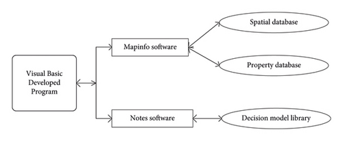
The effective connection between the database and the model library is usually based on the Visual Basic as a research and development tool, as shown in Figure 5. VB technology is a programming language based on common objects developed by Microsoft. The language is an event that includes structure and modules, is object-oriented, and assists in research and development.
3.5. Long-Distance Tourism Experience Training System Effect
The design and application of the enhanced reality virtual travel experience training system is mainly combined with mobile terminals such as smart phones, using the client/training system model. For experience scenes with a high sense of immersion, visitors can wear a powerful reality display device and use gesture recognition device location trackers, data gloves, voice recognition, etc., to enhance actual operations [12, 13]. Control equipment; unify vision, hearing, and other senses; complete the immersive experience of historical relics, characters, and stories; and strengthen the immersive experience effect of the realistic training system.
Among them, the software used to make the data model is 3ds Max. This software is a 3D animation drawing and production software based on the PC system. Compared with other modeling software, 3ds Max has great advantages in terms of accuracy and image presentation efficiency. More importantly, the model constructed by the modeling software can be exported in multiple formats and shared with other types of software with favorable compatibility. Due to its excellent characteristics, 3ds Max currently plays an important role in construction, film, and game production. As shown in Figure 6, the tree model made with this software needs to export the file with form set as Fbx after the required model is made with 3ds Max. The preparation for the next step of interaction (i.e., integration into Unity 3D) is necessary.

In 3ds Max, all scenic spots have buildings, natural plants, and overbridge models, and virtual scenic spots need to be built. The prototype of the produced sample is based on actual sightseeing spots, and the gap between the virtual environment and the actual environment obtained from this is very small [14, 15]. Because there are many models in the scene, each model is numbered for easy retrieval and correction in the future.
3.6. Experiment and Result Analysis
Experimental statistics: This training system shows the impact of students on autonomous learning after class (Table 2).
| Type | Always possible | Often possible | Generally possible | Sometimes possible | Impossible |
|---|---|---|---|---|---|
| Can you recall the relevant knowledge of the classroom teaching when solving the problem? | 87.37 | 6.20 | 3.20 | 2.13 | 1.10 |
| Do you know the process of solving the problem | 86.92 | 6.34 | 3.33 | 2.21 | 1.20 |
| Do you know your problem-solving mistake | 87.21 | 8.25 | 2.22 | 1.14 | 1.18 |
| Can errors be found and corrected in time | 86.33 | 8.02 | 2.21 | 1.77 | 1.67 |
- Note: the data in the table are the proportion of the number of students.
From the analysis in Table 2, it can be concluded that after using the remote tourism teaching and training system based on the adaptive virtual queue algorithm, 87.37% of the students can independently review the tourism knowledge described in the teacher's classroom; 86.92% of the students can solve problems independently after class after using remote tourism teaching and training system; 87.21% of students can find errors and make corrections in time after using the remote tourism teaching and training system, and only 5.12% of the students cannot improve themselves after using the remote tourism teaching and training system. Through the above data analysis, it can be seen that the remote tourism teaching and training system based on the adaptive virtual queue algorithm can improve the learning ability of students.
Analysis of Table 3 shows that after using the training system of this article, the students agreeing that the use of the training system of this article is very helpful to their learning (agree + basic agreement) occupy 92.58%; the students agreeing that the use of the training system of this article improves greatly the learning efficiency (agree + basic agreement) occupy 97.54%; the students agreeing that the use of the training system of this article can help to find errors in time and be corrected occupy 89.84%; the students agreeing that the use of the training system help strengthen the communication between teachers and students (agree + basic agreement) occupy 94.43%; and the students agreeing that the training system in this article could be used widely in schools accounted for 93.57% (agree + basic agreement). Only 4.68% of the students gave negative feedback on the results of the training system of this article. It can be seen from the data that more than 95% of students have good feedback after using the training system in this article.
In order to test the effectiveness of this method, 11 remote tourism teaching and training systems are obtained from the random TV remote tourism teaching and training system. The remote tourism teaching and training system of this group is mainly processed by the computer remote tourism teaching and training system. Standard compression methods are used for compression, and reasonable changes are used to quantify the parameters. As shown in Table 3, 11 images of poor quality are constructed. And, according to the three groups of parameter indicators of subjective evaluation, peak signal-to-noise ratio (PSNR), image quality parameter-isolated SNR, the quality evaluation of the group remote tourism teaching and training system is carried out in turn.
| Type | Always possible | Often possible | Generally possible | Sometimes possible | Impossible |
|---|---|---|---|---|---|
| Participate in after-school communication in the smart education training system | 82.34 | 10.33 | 3.34 | 2.64 | 1.35 |
| Ask the teacher questions in the smart education training system | 86.21 | 10.2 | 2.26 | 1.03 | 0.34 |
| Knowledge of teachers increased | 83.65 | 8.6 | 3.05 | 3.2 | 1.5 |
| Increase in understanding of classmates | 80.58 | 14.84 | 3.33 | 1.2 | 0.21 |
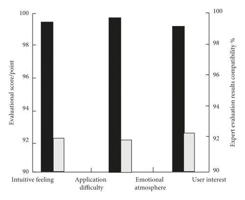
This article is mainly for users to evaluate the design of the tourism teaching and training system, to further grasp the shortcomings of the works, to implement improvements, and to test the adoption rate of different types of remote tourism teaching and training system works after using this method. The evaluation results of this method are shown in Figure 7. By analyzing Figure 8, it can be seen that after applying the method of this article, the design adoption rate of the remote tourism teaching and training system of the tourism teaching and training system is the lowest at 0.98, and many works of the practical training system were adopted. It can be seen that the evaluation effect of this method is very good, and it is one of the application methods of improving the quality of remote tourism teaching and training system as a remote tourism teaching and training system enterprise (Figure 9).
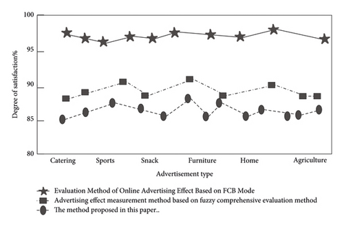
As a method for measuring the effect of the remote tourism teaching and training system based on the adaptive virtual queue algorithm, the effect of the network remote tourism teaching and training system is compared based on FFTB mode, and analysis and comparison of evaluation methods are performed, Figure 8: designer of tourism teaching and training system satisfaction with the three methods. Figure 8 shows the comparison results of the teaching effects of the three methods. By analyzing Figure 8, it can be seen that there are differences in the satisfaction of the three methods of the personnel who design the tourism teaching and training system for the 12 kinds of remote tourism teaching and training systems. The satisfaction of the method here is up to 98.98%, and the satisfaction of the FCB-based network remote tourism teaching and training system effect evaluation method is lower than the method described in this article and is less than 90%, and it is most suitable for reconfirming the application result of the method of this article.
4. Conclusions
This article uses the adaptive virtual queue algorithm calculation method to design the tourism physical reality training system to supplement the gap problem of regional cultural facilities, and in the meantime, it opens up a new direction and thinking for the traditional cultural experience, and allows the Internet to combine with the adaptive virtual queue algorithm. As the core of regional tourism culture, it reflects the value of history and culture and strengthens the significance of cultural exchanges. It has opened up new research directions and new development thinking for regional cultural tourism service design. According to the comprehensive analysis of experimental data, this training system is a high-quality educational training system that can greatly improve the quality of students' learning and the effect of teachers' education.
Conflicts of Interest
The author declares no conflicts of interest.
Acknowledgments
This study was sponsored by Shandong Women’s University.
Open Research
Data Availability
The labeled dataset used to support the findings of this study is available from the corresponding author upon request.


