[Retracted] Study on Meteorological Disaster Monitoring of Field Fruit Industry by Remote Sensing Data
Abstract
Meteorological disasters have brought a great negative impact on people’s lives. With the rapid development of modern science and technology, the detection technology of meteorological disasters has been continuously improved. At present, satellite remote sensing detection technology has made gratifying achievements, and it has a good application in meteorological disaster prediction. In this paper, the application of satellite remote sensing technology in the process of meteorological disaster monitoring is discussed in depth. In traditional work, the accuracy and timeliness of meteorological disaster monitoring is the key and difficult point of meteorological disaster prevention. Using satellite telemetry to monitor meteorological disasters can effectively improve the accuracy and timeliness of meteorological disaster monitoring, provide reasonable solutions and decision-making basis for meteorological disaster prevention, and achieve the purpose of disaster prevention and mitigation. This paper introduces the basic principle, technical system, and important role of satellite remote sensing technology, expounds on the application of satellite remote sensing technology in the monitoring of agricultural meteorological disasters such as water, drought, freezing, and hail, and provides a scientific reference for farmers, agricultural sustainability, and agricultural decision-making. The continuous development of our country’s modern social economy has put forward higher requirements for agricultural production. Traditional monitoring technology can no longer meet the needs of agricultural meteorological disaster monitoring. The scientific application of remote sensing monitoring technology has important value, which can effectively improve the detection level and make it have higher accuracy and real-time performance, thereby promoting modern agricultural production in China. Based on the analysis of the application value of remote sensing monitoring technology, this paper comprehensively discusses the specific conditions of different disasters monitored by remote sensing monitoring technology in agricultural production.
1. Introduction
Meteorological disasters refer to accidents and disasters caused directly by weather, climate, and other weather factors or indirectly. The current meteorological disaster influence on our daily life is very much. In many cases, with the development of the economy and the advancement of science and technology, meteorological disasters can be monitored. Reducing the impact of meteorological disasters on us before the accident and reducing the loss of national property are the main directions of research. We can predict and monitor the meteorological situation through advanced science and technology to prevent tragedies and avoid losses, which is also the embodiment of the development of science and technology and social progress. This paper explores the application and development of remote sensing technology in disaster prevention and disaster avoidance process through the introduction of the concept and characteristics of satellite remote sensing technology [1].
Meteorological remote sensing technology is a method to predict weather and climate disasters by calculating the physical parameters corresponding to ground, sea, weather, and climate conditions using certain calculation programs through radiometric measurement. Remote sensing technology has been fully verified in many large-scale meteorological disaster monitoring work and achieved good results. The specific implementation of meteorological remote sensing technology is to monitor atmospheric temperature and humidity, wind speed and direction, cloud movement, and other physical elements through various types of equipment equipped on the man-made Earth satellite for monitoring weather and climate physical parameters. Such artificial Earth satellite is usually called the weather satellite [2–5]. Equipped with a satellite remote sensing device, it can acquire and monitor the mainland and in the air can identify light and infrared rays; through conversion, equipment will catch the light, convert it to electrical signal data, and then forward it to the receiving station; the station will get the data information through the computer software for processing, weather map information, clouds, sea, ground figure, and so on. Then special software is used to process and finally form the meteorological data that people need.
Compared with other monitoring technologies, the meteorological remote sensing technology has the following characteristics: First, the detection area of remote sensing technology is very wide, which can realize real-time dynamic monitoring. As remote sensing technology is to measure data through radiation of the meteorological satellite, monitoring frequency is more frequent than other technologies [6]. Remote sensing technology can be used for daily weather forecast, ocean and river detection, atmospheric quality monitoring, and environmental detection, and China has a number of weather satellites. Second, the satellite has high observation efficiency and good detection data quality. Third, meteorological satellite monitoring has no space and regional obstacles and no requirements on air quality and environmental conditions. Accurate and timely detection can be carried out continuously [7–10].
Based on the electromagnetic wave theory, remote sensing shows that the content of biochemical components and canopy structure of crops change before and after the disaster, and the electromagnetic wave received by sensors also changes accordingly. Through comparative analysis of electromagnetic wave information before and after the disaster, the disaster situation of crops can be obtained [11]. At present, remote sensing disaster monitoring has been carried out, including flood disaster, drought, snow disaster, sandstorm, pests and diseases, and typhoon. Due to the physiological and biochemical effects of various disasters on different crops, such as the occurrence of floods, the core of the impact on plants is excessive liquid water. Plants grow in an oxygen-deficient environment, plant growth is small, leaves yellow, petioles grow obliquely, the root system is shallow and thin, and the hair is noticeably reduced. Then, it turns black, rots, and stinks, and soon the whole plant dies. Drought refers to the phenomenon of crop wilting due to the lack of soil moisture or low atmospheric relative humidity. Many crop diseases are characterized by wilting or withering. Freezing injury often causes the freezing of plant tissues, resulting in plant injury or even death [12]. The phenomena presented by different disasters of various crops are different, and they also have their own characteristics in the spectrum, so the remote sensing monitoring methods are different.
The paper is organized as follows: Section 1 introduces the domestic and foreign research situation of the full text, Section 2 introduces the related work, Section 3 introduces the construction of agrometeorological disaster indicators, Section 4 carries out simulation experiments, and Section 5 summarizes the paper.
2. Related Work
Meteorological conditions directly affect the development of agriculture, and good meteorological conditions are the key to the healthy development of agriculture. In China, meteorological disasters have a great impact on agricultural development. After the occurrence of meteorological disasters, monitoring and evaluation of the disaster situation by relevant departments is an important means of disaster relief. Accurate assessment can reduce disaster losses to a certain extent and provide an objective basis for the formulation of disaster prevention plans [13–16].
2.1. Principles of Agricultural Remote Sensing Disaster Monitoring
2.1.1. Remote Sensing Flood Disaster Monitoring
Relevant investigation shows that the purpose of multiband satellite data classification is to obtain water inundation information. At present, some new recognition methods appear in our country, such as manual recognition, computer image classification, and water discriminant function. However, remote sensing technology still has some shortcomings in flood disaster monitoring, so it needs to be studied pertinently.
2.1.2. Remote Sensing Drought Disaster Monitoring
Agricultural drought refers to the situation that crops lack the necessary water due to the lack of rainfall and late irrigation in the growth process of crops, resulting in production reduction. Soil water content and water demand are the key factors to reflect the degree of drought. Remote sensing technology can calculate soil water content through the change of soil temperature difference between day and night and realize the control of soil water content. Although this method has high accuracy, it is difficult to monitor water content in the seed germination and growth stage [17].
2.1.3. Sandstorm Monitoring by Remote Sensing
In the process of aeolian sand activities, the disaster factors have certain characteristics, that is, risk and vulnerability. In China, sandstorm mainly occurs in spring; once sandstorm weather occurs, crops and grass will be affected. The thick sand covering the leaves of plants not only affects photosynthesis but also reduces crop yield [18].
2.1.4. Remote Sensing Monitoring of Pests and Diseases
When crops are affected by meteorological disasters, the different degrees of disasters can be shown in the bands of remote sensing satellites. Some related scholars have analyzed the remote sensing monitoring of pests and diseases of various crops, and at the same time, they have also established the vegetation index and the remote sensing recognition algorithm for pests and diseases monitoring [19].
2.2. Development Needs and Focus on Solving Problems
2.2.1. Rapid Response after Disaster Is the Key to Realize Agricultural Industrialization
The progress of science and technology promotes the rapid development of productive forces at the same time; it also creates a certain labor surplus. In order to pursue better living conditions, some people have poured into the city, which has led to the phenomenon that the number of rural arable lands is less and less, providing necessary conditions for the development of agricultural industrialization. At the same time, the reduction of the number of people will increase the amount of arable land and make it easy to form the scale of agriculture; the degree of dependence on science and technology will deepen accordingly [20–22]. Therefore, in order to improve agricultural productivity, advanced science and technology is particularly important.
2.2.2. Providing Certain Guarantee for Agricultural Insurance
China’s agriculture is greatly affected by meteorological disasters, and the risk of agricultural operation is great, which requires agricultural insurance to share part of the risk and reduce part of the loss. Agriculture, rural areas, and farmers are important issues in agricultural development, and agricultural insurance can provide an important guarantee for agriculture, rural areas, and farmers. At present, the business scale of agricultural insurance in some areas of our country is not large, and the main reasons are as follows. The scale of farmers’ operations is relatively small, and most of them are not enthusiastic about participating in agricultural insurance. Although they participated in agricultural insurance in time, it was still difficult to be investigated. Therefore, the establishment of meteorological disaster monitoring and assessment system will greatly contribute to the development and popularization of agricultural technology.
2.2.3. Deficiencies of Remote Sensing Monitoring of Agricultural Meteorological Disasters
Agricultural remote sensing research in China began in the 1980s, and this technology has been used in agricultural management and production in some regions of China. At present, China still has some shortcomings in this kind of technology, mainly for the following reasons: China’s agricultural production is open. There are many factors influencing agricultural development, such as seed quality, cultivation and management measures, and ecological environment. Different kinds of crops have different degrees of disaster. Moreover, the same crops are affected differently at different stages of development. Related studies show that remote sensing monitoring of the same object with different spectrum and foreign body with the same spectrum phenomenon is relatively common. In the process of agricultural planting and management in the past, the loss after meteorological disasters was less than that in research. If remote sensing technology is used for disaster assessment, it is necessary to develop a comprehensive disaster monitoring and assessment system from various aspects. Agricultural remote sensing technology is based on spectral analysis. When agricultural disasters occur, if the weather conditions are not good, it will increase the difficulty of obtaining remote sensing information.
Meteorological disaster emergency management institutions and their constituent elements system can be theoretically summarized as the basic content shown in Figure 1.
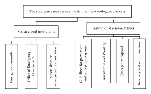
Figure 1 introduces the basic elements of the meteorological disaster emergency management system and makes a clear analysis of the relationship between the various elements.
2.3. Application of Meteorological Satellite Remote Sensing Technology
Meteorological satellites play an important role in weather and climate. Through light line recognition equipment equipped with satellites, different areas are monitored to form cloud images. Seawater is usually black in the cloud images, while continents are gray, and snow and ice-covered areas are white. Red diode equipment is used to detect the humidity and temperature changes in the air in different areas, combined with the cloud map to depict the distribution of water and rainfall in the atmosphere. “Haze” is a frequent weather phenomenon, which occurs when the visibility of urban roads is low, which is easy to cause traffic accidents and affect people’s travel. Remote sensing technology can effectively detect the “haze,” timely issue the “haze” warning, remind people to make preparations before timely mention, and prevent the occurrence of accidents. Satellites can express the degree of “haze” in the form of images and achieve real-time detection, which is convenient for us to intuitively monitor air quality [23].
Meteorological satellite remote sensing technology is mainly used to monitor sea ice and river ice flood. As many sea surfaces in China will freeze in the cold season, the scope and conditions of the freeze will affect the transportation of ships at sea, the acquisition of oil fields, the docking of ships at coastlines and ports, and so on. It is necessary to monitor the state of the freeze in real time and issue a warning to avoid the occurrence of harm. The detection of sea ice is also based on the difference between ice and water in spectral properties of discernible light and infrared light. Through the processing of data information, we can extract which areas have been frozen, which sea surface is still seawater, and the extent of the ice. In addition, during our expedition to the North and South Poles, we should also monitor the state of sea ice, predict the state of the ice in advance, and make investigation plans to avoid accidents. Ice-melting flood means that the lower part of the river ice is on the surface, and the upper part is massive, forming a dam. Over time, the upstream water level continues to rise and eventually develops into a dyke burst, causing serious disasters and accidents. Satellite remote sensing technology can effectively monitor river ice conditions. After the ice in front of the dam does not reach the early warning, the relevant departments are notified to take immediate measures to avoid the occurrence of ice floods [24].
In China, drought, sandstorms, and other meteorological disasters occur from time to time. Meteorological satellites can monitor the moisture on the soil surface and the temperature of surface plants, judge the water content of the soil, and predict the occurrence of drought. The phenomena such as additional, sand, dust storms often occur in our country in the western region; satellite remote sensing technology can be used to identify infrared light of dust and the reflection rate of the ground and to identify the occurrence of dust storms. Using remote sensing technology to identify sand and dust storms has a high recognition rate, but this method is only suitable for monitoring during the day, and the reflectivity is insufficient at night, so it is difficult to identify.
Monitoring fire and typhoon satellite remote sensing technology and its application, there is radiant heat during fire, and the quality of ground meteorological satellites can be continuously monitored. Once a fire occurs and the temperature rises, the sensor can detect the wavelength change of radiant heat, which can identify the occurrence of fire and form. The image can intuitively reflect the area and extent of the fire. Remote sensing technology is mainly used in the monitoring of typhoon cloud map technology; in the cloud map, we can clearly see the center of the typhoon, change trend, moving speed, and so on, predict the impact of the typhoon in advance, and prevent the occurrence of disasters.
3. Construction of Agricultural Meteorological Disaster Indicators
Drought is the most common and the most serious natural disaster in agricultural meteorology. It is related not only to precipitation but also to temperature, humidity, evaporation, soil moisture, and other factors. Determining the drought index is an important basis and prerequisite for drought monitoring and early warning. Selecting appropriate monitoring and early warning index can provide a scientific basis for agricultural meteorological disaster prevention and reduction, which is also necessary for this system. In order to find the most scientific drought index and provide the best countermeasures for disaster prevention and reduction in Jiangsu Province, this system selects the following common drought indexes for comparative analysis.
Mi is the percentage of precipitation anomaly in period I, I represents a certain period of time, Ri represents precipitation in this period, and R represents the average precipitation for many years in the same period.
σ is the mean square error, Xi is the precipitation in a certain year, X is the average precipitation in N years, and n is the sample number.
ET0 is the potential evapotranspiration; △ is the slope of the relation curve between saturation vapor pressure and temperature.
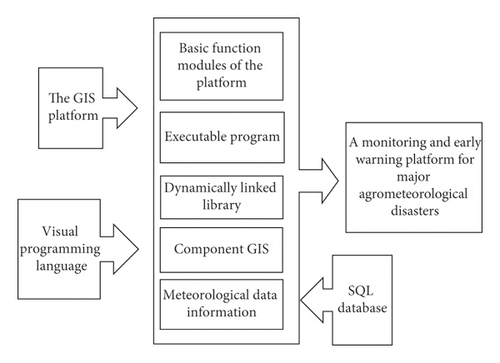
The simple secondary development is limited by the programming language of GIS tools. Therefore, the integration of GIS software and visual development language has become the mainstream of GIS development. Component-based GIS development technology can not only make full use of GIS functions, but also make use of its object-oriented visual programming language and other characteristics of development due to its simple, powerful, and flexible GIS development functions, and no need to directly embed GIS development languages. Improve the development efficiency of the application system, and the developed program has a more powerful database function and a more beautiful system interface. Based on the above advantages, this study mainly adopts the component GIS development mode to develop the monitoring and early warning system of major agricultural meteorological disasters in Jiangsu Province based on RS and GIS, giving full play to the advantages of geographic information technology and meteorological data processing. The comprehensive development process is shown in Figure 2.
4. Experimental Results and Analysis
In this study, hyperspectral mechanism, whole-process identification and monitoring of rape freezing injury, regional monitoring of oilseed rape freezing injury, and remote sensing inversion of biophysical parameters related to rape freezing injury were studied. According to the purpose of the study, the experimental data involved included temperature data, indoor spectral data, physiological and biochemical parameters of rape leaves, canopy structure parameters, and satellite image data with different spatial resolutions. The following is an introduction to the instruments and methods used in data acquisition.
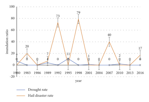
From 1980 to 2018, the average disaster rate of drought in Panjin city was 0.78%, and that of hail was 0.09%. From the disaster rate, the Panjin drought disaster rate is higher than the hail disaster rate. Drought and hail were 75.8% (1994) and 11.5% (1990), respectively. From 1980 to 2018, there was no drought or hail disaster in 22 years, and drought and hail disaster occurred in 2 years, accounting for 5.1%. During this period, the incidence of the drought was 20.5%, and there was about one drought in 4.8 years, but from 2015 to 2018, there was about one drought in 1.3 years. The incidence of hail disaster was 28.2%, and it happened once in about 3.5 years. From 2011 to 2018, hail disaster happened once in about 2 years, as shown in Figure 3. The incidence of hail is higher than that of drought.
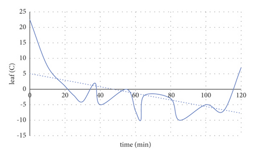
Supercooling refers to the lowering of plant cell temperature below freezing point, but not immediately freezing, and it is a common mechanism for plants to avoid freezing injury. In order to determine the temperature of leaves in the state of undercooling, the leaf temperature curves of several rapeseed plants were measured under the condition of fixed freezer gear, and the freezing point temperature and undercooling point temperature were recorded many times. According to several measurements of freezing point temperature and supercooling point temperature, it is concluded that the supercooling of rape leaf in this study refers to the state when the leaf temperature reaches. A typical rapeseed leaf temperature curve is shown in Figure 4.
Spectral observation experiment of rapeseed freezing injury process at different freezing times: the experiment was sown on October 20, 2014, and 100 rapeseed plants were planted in total. The effects of rapeseed varieties, tested soil, and rapeseed management on cell structure and water content of rapeseed leaves were consistent with those of freezing injury treatment. The main growth process of rape from sowing to the beginning of treatment is shown in Figure 5.

Statistics of water content in rape leaves under normal and frozen conditions are shown in Table 1. T-test of paired samples showed that there was no significant difference in water content between normal and frozen rapeseed leaves (A = 0.05; B = 0.648).
| Max | Min | Avg | The standard deviation | Coefficient of variation | |
|---|---|---|---|---|---|
| Normal | 0.922 | 0.753 | 0.868 | 0.042 | 20.456 |
| Frozen | 0.924 | 0.758 | 0.869 | 0.043 | 20.088 |
The changes of SPAD value in the whole process of rape leaf freezing injury are shown in Figure 6. On the whole, the value of SPAD decreased in the whole process of rape freezing injury. The SPAD value in the state of supercooling and icing for 1 hour decreased less than that in the normal state. After 2 hours of thawing, the SPAD value decreased significantly compared with the normal SPAD. SPAD values were more variable 2 h after thawing, possibly due to uncertainty in the measurement of SPAD values. Finally, the rape leaves have turned yellow, close to death. The paired sample T-test was used to test the significance of the difference between the SPAD values under normal and 1-hour icing conditions, and the results showed that the difference was not significant (a = 0.05; P = 0.056).
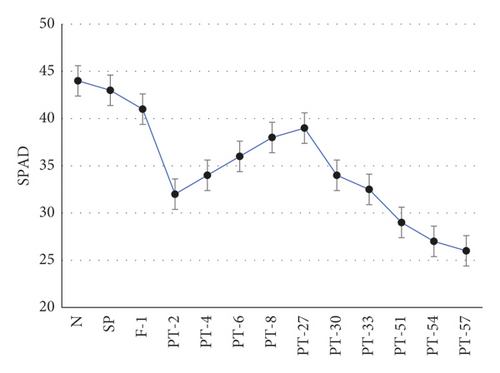
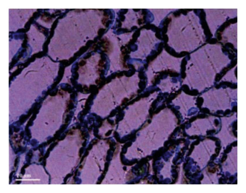
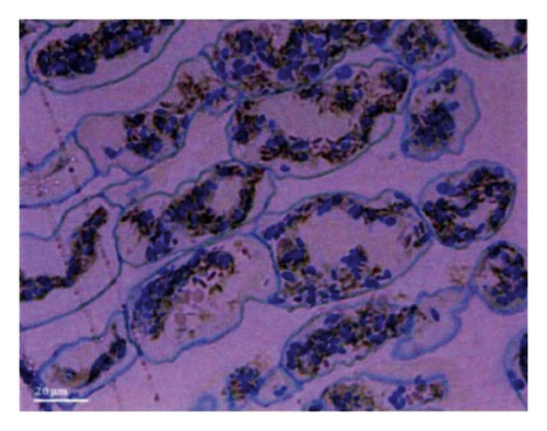
Figure 7 shows the changes of cell structure in rapeseed leaves under normal and 1-hour icing conditions. Light microscopy can observe changes in cell microstructure, including changes in cell shape and volume as well as changes in larger organelles inside the cell such as chloroplasts and mitochondria. Figure 7(a) shows the microstructure of leaf cells in rapeseed under normal conditions. It can be seen that the cell structure is intact, the cells are closely arranged, the cells remain dilated, and the chloroplast surrounds the edge of the cell wall. When rapeseed leaves froze, due to the water potential difference caused by ice between cells, cells were dehydrated to varying degrees, leading to atrophy of cells and loss of original turgor, cell inclusions clustered to the middle, and the gap between cells became larger. In addition, the organelles, especially the chloroplasts, were damaged.
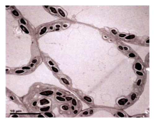
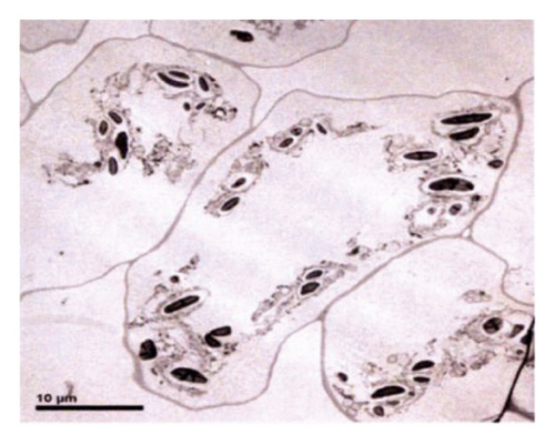
Compared with the optical microscope, the electron microscope has higher magnification and resolution and can observe the changes of cell submicroscopic structure, such as grana and starch grains in the chloroplast. Figure 7(c) is a radio-lens image of leaf cells in rape under normal conditions. You can see that the chloroplast structure is intact and is distributed around the cell wall. When rapeseed leaves froze, it could be seen that chloroplast stroma lamella was damaged, chloroplast membrane was damaged, and starch grains had been separated from the chloroplast. It can be concluded that icing destroys the photosynthesis of chloroplast in rape leaves.
Stomatal conductance (Gs) and transpiration rate (Tr) gradually decrease to close to zero. Intercellular carbon dioxide concentration (Ci) increases rapidly and then remains relatively stable. The combination is shown in Figure 7. The ice layer seriously damages the cell structure of rapeseed leaves, resulting in serious damage to the physiological function of rapeseed during the thawing process. The net photosynthetic rate, transpiration rate, and stomatal conductance decrease rapidly. The carbon dioxide concentration between cells is close to the environment. The blade is seriously injured, and the blade is dying. Photosynthetic parameters were not measured at 54 and 57 hours of thawing, mainly because leaves were dried and broken, and leaf chambers were difficult to clamp, which led to the decrease of measuring accuracy. Changes of net photosynthetic rate are shown in Figure 8.

Figure 8 shows the changes of photosynthetic parameters in the thawing process of rape leaves. As can be seen from the figure, the net photosynthetic rate (Pn) of rapeseed leaves decreased to near zero after 2 hours of thawing, indicating that photosynthetic organs of leaves were destroyed and photosynthetic rate and respiration rate were basically equal.
5. Conclusion
This paper proposes using satellite remote sensing to predict and analyze meteorological disasters. On the basis of systematic analysis and componentization of geographic information systems at home and abroad, based on theory and technology, a variety of agricultural meteorological disaster indicators are analyzed. On the basis of the monitoring and early warning system of major agro-meteorological disasters in Jiangsu Province, a variety of early warning indicators for agro-meteorological disasters such as RS and GIS are developed. Agricultural remote sensing is mainly based on spectral analysis. After agricultural disasters, basic information cannot be obtained in bad weather (cloudy). In addition, the acquisition of satellite data has a certain periodicity, which increases the difficulty of remote sensing monitoring. In order to improve the value of remote sensing technology in agricultural meteorological disaster monitoring, it is necessary to gradually carry out the research and application of UAV aerial photography and radar remote sensing monitoring technology. Fourth, the occurrence and development of agrometeorological disasters are mainly affected by meteorological factors and have certain suddenness. Positioning observation can only obtain occasional data in a certain situation, and it takes a long time to obtain data compared with systematic data.
Conflicts of Interest
The authors declare that they have no conflicts of interest.
Acknowledgments
This work was supported by the National Natural Science Foundation of China (Grant nos. 42171332and 41901068) and the Major Science and Technology Projects of Xianyang (Grant no. 2020K01-33).
Open Research
Data Availability
The data used to support the findings of this study are available from the corresponding author upon request.


