Modeling current and future habitat suitability of an iconic bird to inform restoration planning in southeastern Louisiana, U.S.A.
Author contributions: EIJ, NLM conceived and designed the research; KLP, NLM, LN managed and analyzed the data; KLP, NLM, JF, LN, EIJ wrote and edited the manuscript; EIJ, NLM acquired project funding.
Abstract
Louisiana is facing a land loss crisis with 5,000 km2 lost since the 1930s, and another 10,000 km2 may disappear over the next 50 years. In response, the state developed a Comprehensive Master Plan for a Sustainable Coast, which includes predictions for how wildlife species respond to futures with or without restoration action. However, the 2017 Master Plan did not include a bird species representative of brackish or freshwater wetland habitats. Our objective therefore was to evaluate the potential for the Bald Eagle (Haliaeetus leucocephalus) to serve as an indicator of freshwater wetland health, and to develop a model to predict Bald Eagle responses to land cover change 20 and 50 years into the future, with or without restoration action. Using nest location data collected by the Louisiana Department of Wildlife and Fisheries from the Barataria Basin, we modeled the relationship between Bald Eagle nest occurrence and land cover using boosted regression trees. Model performance was strong, explaining 54.4 ± 0.1% of the deviance in nest occurrence, and showed that Bald Eagle nests were more common in areas with greater fresh forested wetland, freshwater marsh, and flotant marsh land cover. Future suitability for nesting Bald Eagles was higher in 20 and 50 years with restoration action compared to without, although suitability in both years was lower than contemporary suitability, regardless of restoration action. Our model suggests that comprehensive restoration action is needed, including the implementation of Mississippi River diversions, to sustain high densities of nesting Bald Eagles in coastal Louisiana.
Implications for Practice
- Modeling potential effects of restoration projects on key wildlife species that represent a diversity of habitat types can inform project selection and evaluation.
- The boosted regression tree modeling approach used here demonstrates its success in developing Habitat Suitability Indices for conservation planning needs when there is insufficient data to model abundance relationships and data are right-skewed.
- Quantifying the predicted benefits of a future with restoration action compared to a future without action on an iconic species, such as the Bald Eagle, can help generate public support for implementing large-scale restoration projects, helping to overcome challenges related to cost and effort.
Introduction
Louisiana has experienced greater coastal land loss than all other states in the U.S. combined. Between 1932 and 2016, over 4,661 km2 have disappeared due to climate change-driven sea level rise, more frequent and intense tropical cyclones, storm surge, deltaic subsidence, oil and other anthropogenic development, and alterations to the Mississippi River's flow (Coastal Protection and Restoration Authority [CPRA] 2017; Couvillion et al. 2017). Continued land loss projected to be approximately 10,000 km2 in 50 years without restoration action (Reed et al. 2020), which threatens considerable natural and renewable resources (e.g. $2 billion dollars annually from fish and wildlife activities) as well as significant biodiversity loss from over 3.6 million hectares of swamp, marsh, and barrier shoreline (McKenzie et al. 1995; Lindstedt 2005).
To address this land-loss crisis, the state of Louisiana developed a Comprehensive Master Plan for a Sustainable Coast, which delineates restorative construction projects and adaptive management as funding becomes available (CPRA 2017). To help identify priorities for and measure effectiveness of restoration, the 2017 Coastal Master Plan is informed by habitat suitability models for an array of fish and wildlife species. The species included are chosen as indicators that illustrate the potential response of the species' larger ecological communities and their associated habitats to restoration and protection efforts. A total of 12 species of fish, shellfish, reptiles, and birds were included in the 2017 Coastal Master Plan. The selected species are economically important to Louisiana's recreational or commercial industries and represent a diversity of life history traits and habitat use (Lindquist et al. 2021). Although these species together span a diverse range of coastal Louisiana habitats, no bird species were included that represent the upper estuary, that is, freshwater wetlands. Consequently, this markedly vulnerable habitat characterized by emergent and tidal freshwater forested wetlands (TFFWs) and supporting a diverse wildlife community was not fully represented in the Coastal Master Plan.
Tidal freshwater forested wetlands are considered some of the most productive systems in the world (Baldwin et al. 2009) and provide significant ecosystem services at the intersection of marine and terrestrial environments. These services include, but are not limited to, flood and storm water protection, regulation of water quality (Korol & Noe 2020), carbon sequestration (Krauss et al. 2018), food and recreation provisioning, and wildlife habitat (Carter 1990; Williams et al. 2019). In 1988, the state of Louisiana accounted for 44% of coastal freshwater marshes in the conterminous United States (Field et al. 1988), making it a critical region for freshwater species conservation. The species of greatest conservation need dependent on coastal freshwater wetlands, including emergent freshwater marsh, flotant marsh, and cypress-tupelo swamp forest, include 5 arthropods, 5 fish, 3 amphibians, 3 reptiles, 36 bird, 7 mammals, and 21 plants (Holcomb et al. 2015). Unfortunately, the coastal TFFWs, streams, and freshwater emergent wetlands that sustain these species are among the most stressed and vulnerable to human development, including alterations to river hydrology, and climate change as sea level rise and saltwater intrusions diminish productivity (Holcomb et al. 2015; Williams et al. 2019; Reed et al. 2020). Louisiana's coastal wetlands in particular have faced severe and long-term degradation, sediment loss, and saltwater intrusion due to infrastructure development (e.g. dams, levees and floodwalls; Day et al. 2007) and oil and gas construction (e.g. pipelines, wells and navigation canals; Priest & Theriot 2009).
Louisiana's coastal wetland loss and degradation has affected the many wildlife species that call the region home. Although impacts on many wetland species may go unnoticed or underappreciated because of their often secretive nature, the charismatic and iconic Bald Eagle (Haliaeetus leucocephalus) has the potential to serve as a highly visible indicator of the threats. In addition to its visibility, the Bald Eagle remains a conservation priority species that demonstrates a preference for freshwater habitats (Watts et al. 2006; Smith et al. 2017), which contribute to its potential as a key indicator of ongoing TFFW and freshwater emergent wetland threats in the region. The Bald Eagle suffered devastating population declines throughout its range during the 1950s through the 1970s as a result of dichlorodiphenyltrichloroethane and other organochlorine pesticides (Grier 1982). Populations have since rebounded, and the species was formally removed from the U.S. Fish & Wildlife Service's endangered species list in 2007 (U.S. Fish and Wildlife Service 2007). Louisiana's Bald Eagle population, which dropped to a low of approximately 5 nesting pairs in the 1970s, now exceeds 350 nesting pairs (Lowery Jr 1974; Holcomb et al. 2015). Its recovery highlights the success of legislation to regulate pesticides. However, ongoing population recovery in coastal Louisiana may be dependent on the continued availability of suitable habitat that, in turn, may be impacted by coastal erosion, sea level rise, and increased hurricane intensity among other threats (Wilson et al. 2019).
Bald Eagle nesting populations in Louisiana have been most heavily concentrated in the south-central and southeastern part of the state where land loss rates are among the fastest in the country (Couvillion et al. 2017; Smith et al. 2017). Such land loss, particularly from sea level rise, can significantly threaten freshwater-dependent species as saltwater intrusion increases. Bald Eagles have demonstrated an aversion to estuarine wetlands with high salinity (Watts et al. 2006), which may diminish the availability of preferred nesting trees and/or forage fish species (Seymour & Coulson 2019). To reduce the inland spread of saline and brackish wetlands, Louisiana is undergoing large-scale restoration planning and implementation efforts to stabilize freshwater wetlands (CPRA 2017). Consequently, the success of coastal restoration efforts in Louisiana may have important long-term implications for the continued recovery of Bald Eagles in the region. Therefore, we set out to evaluate the current-day habitat suitability for nesting Bald Eagles across south-central and southeastern Louisiana, and use this model to predict future habitat suitability with and without planned restoration actions. As coastal restoration aims to maintain emergent wetlands and reduce saltwater intrusion, we predict that there will be more suitable Bald Eagle habitat under restoration scenarios than in a future without restoration action.
Methods
Study Species and System
Bald Eagles, the national bird of the United States, preferentially nest in wooded freshwater wetlands which provide nesting platforms (Smith et al. 2017). They build large, heavy nests in the crook of large trees (Buehler 2020) that are easily detected in aerial surveys. Their nests are commonly found close to water and emergent wetlands (Smith et al. 2017; Seymour & Coulson 2019; Buehler 2020). These wetlands provide habitat for common prey species that in the southeastern United States include muskrat (Ondatra zibethicus), American Coot (Fulica americana), dabbling waterfowl, and several benthic fish species (e.g. freshwater catfish [Ictalurus spp.], bowfin [Amia calva], and freshwater drum [Aplodinotus grunniens]) (Dugoni et al. 1986).
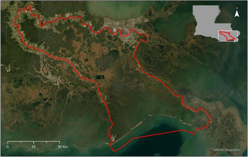
Our study area was the Barataria-Terrebonne Estuarine System, which includes coastal southeastern Louisiana east of Bayou Lafourche and south (and west) of the Mississippi River (Fig. 1). The Barataria-Terrebonne Estuarine System is home to roughly 735 estuary-dependent species, 682 of which are vertebrates (Lindstedt 2005). We selected this region because of the high abundance of Bald Eagle nests and because it contains a complete estuary gradient from forested freshwater wetlands and emergent freshwater wetlands to saline wetlands and open water. It also has large extents of each of the key habitat categories (see below), thus provides a sound study design framework for testing the development of a habitat suitability index and the conclusions of this research may be used to estimate habitat suitability for nesting Bald Eagles across the coast of the northern Gulf of Mexico where nest locations and habitat types have been effectively mapped. This region is also one of the continents' most vulnerable ecosystems, with high rates of land loss and habitat conversion, providing the opportunity to test responses of nesting Bald Eagles to existing models of future land and habitat change scenarios 20 and 50 years into the future (CPRA 2017).
Louisiana's Coastal Master Plan (CPRA 2017) offers a $50-billion, 50-year vision and roadmap for maximizing the sustainability and recovery of coastal wetlands to benefit human communities that live and work in the region, as well as to benefit wildlife and the habitat on which they depend, given a finite availability of resources (i.e. funding). About half of the cost outlined in the Master Plan is allocated for structural enhancements, such as levee construction and elevating homes. The remainder highlights 124 green infrastructure and restoration projects that have been modeled and selected as the most effective to build or maintain over 2,100 km2 of land. The restoration tools include ridge restoration, shoreline protection, barrier island restoration, marsh creation, sediment diversion, and hydrologic restoration projects.
Survey Methods
In 1984, Louisiana Department of Wildlife and Fisheries (LDWF) started surveying nesting Bald Eagles within the state. For our analysis, we used LDWF's aerial surveys that were flown during the 2014–2015 nesting season (December to April). Nests were marked as active (i.e. with eggs, chicks, or incubating adults) or inactive, and only active nests were included in these models. Selection of aerial routes was nonrandom, instead focusing on historical and modern nest site records maintained by the LDWF Wildlife Heritage Program (see Holcomb et al. 2015 for more detailed survey protocol). Even so, it is unlikely that many Bald Eagle nests were missed, given their size and relative ease of detection by air. LDWF also flies systematic aerial transects for wintering waterfowl and nesting alligators throughout coastal Louisiana, which helped biologists track the ongoing expansion of Bald Eagle nests as well (M. Seymore 2022, LDWF, personal communication). Similarly, bird watchers, construction and development personnel, and community members have regularly reported eagle nest sites to be included in the LDWF Wildlife Heritage Program since the recovery of Bald Eagles into the region since the 1970s.
Data Summary
Bald Eagles build nests in large trees that have suitable foraging habitat nearby, though the tree itself may be removed a short distance from their preferred land cover types (Buehler 2020). Therefore, to evaluate nesting habitat suitability, we looked at land cover surrounding the nest site using a grid system based on the species' known home range size. We developed a 25 km2 (5 × 5 km) grid system overlaying the Barataria Basin, based on published core home range size estimates 45.8 ± 11.0 km2 (95% use area ± SE) and 2.2 ± 0.8 km2 (50% use area ± SE) from nesting Bald Eagles in Louisiana (Smith et al. 2017). We counted the number of Bald Eagle nests detected within each grid cell. The final Barataria Basin dataset included 250 grid cells, of which 27 cells contained 1 or more Bald Eagle nest. Because of the relatively small proportion of grid cells with nests, and the low numbers of nests within each cell (range: 1–5, mean ± SE = 1.81 ± 0.21), the count data were strongly skewed and there was insufficient information to model abundance relationships. Therefore, we used nest occurrence (i.e. detection and nondetection) as our response rather than counts.
To model current-day habitat suitability we calculated the percent cover of each of 10 land cover classes (Table 1) within each grid cell using land cover data from 2014 (CPRA 2017; Couvillion 2017), supplemented by the 2016 National Land Cover Database (Dewitz 2019) to further classify CPRA's “bare ground” category as either upland or developed. The resulting land cover classes included flotant marsh, fresh forested wetlands, fresh marsh, intermediate marsh, brackish marsh, salt marsh, upland, developed land, and water. Land cover classes were classified at 30-m resolution, therefore most grid cells included multiple land cover types (range: 1–10). These data also characterized habitat types in the Louisiana coastal zone at six time intervals projecting from the present to +50 years, at 10-year intervals. Habitat distributions for each of the 10-year intervals were modeled according to two scenarios: with and without implementation of coastal restoration projects, which included sediment and freshwater diversions, hydrologic restoration, marsh creation, ridge restoration, shoreline protection, and barrier island/headland restoration (see CPRA 2017 for maps of the location of restoration projects and detailed descriptions). To model future (20- and 50-year) habitat suitability with or without restoration action, we clipped or “cookie-cut” the 20- and 50-year habitat data with the 5 × 5 km grid file and grid squares containing more than 50% of the clipped data were summed according to habitat type.
| Land Cover Class | Species |
|---|---|
| Brackish marsh | Spartina patens, Paspalum vaginatum |
| Developed | No species included |
| Flotant | Panicum hemitomon, Eleocharis baldwinii, Hydrocotyle umbellata |
| Fresh forested | Quercus lyrata, Quercus texana, Quercus laurifolia, Ulmus americana, Quercus nigra, Quercus virginiana, Salix nigra, Taxodium distichum, Nyssa aquatica |
| Fresh marsh | Morella cerifera, Panicum hemitomon, Eleocharis baldwinii, Hydrocotyle umbellata, Sagittaria latifolia, Zizaniopsis miliacea, Cladium mariscus, Typha domingensis, Schoenoplectus californicus |
| Intermediate marsh | Sagittaria lancifolia, Phragmites australis, Iva frutescens, Baccharis halimifolia |
| Salt marsh | Juncus roemerianus, Distichlis spicata, Spartina alterniflora, Avicennia germinans |
| Upland | No species included |
Modeling Technique
We modeled the relationship between Bald Eagle nest occurrence and land cover using boosted regression trees (BRTs), a machine learning approach that is ideal for modeling complex curvilinear relationships with multiple and often highly correlated environmental variables (Elith et al. 2008). Models were fit using packages dismo (Hijmans et al. 2015) and gbm (Greenwell et al. 2020) in R version 3.5.1 (R Core Team 2018). The response variable was detection (1) or nondetection (0) of one or more Bald Eagle nests.
BRT models use three regulation parameters to shrink the number of terms in the final model and thus avoid overfitting. Learning rate shrinks the contribution of each tree in the full boosted model; bag fraction specifies the proportion of data to be selected from the training set at each step; and model tree complexity determines the number of nodes and, consequently, level of interactions between predictors (Elith et al. 2008). We iteratively tuned these parameters to optimize model fit while ensuring a minimum of 1,000 trees using default parameter ranges recommended by Elith et al. (2008): learning rate 0.0001–0.1, bag fraction 0.50–0.75, and model tree complexity 1–3. At each step, we used 10-fold cross-validated area under the receiver operating characteristic curve (hereafter AUC), a measure of discriminatory capacity, and residual deviance to select the optimal parameter value. To reduce bias due to spatial autocorrelation, we used spatially stratified cross-validation by dividing the dataset into 11 bins by latitude and longitude and withholding 1 latitudinal bin for testing at each fold (Roberts et al. 2017). We tested for residual spatial autocorrelation in the final model using Moran's I, calculated in the R package ape (Paradis et al. 2004). Moran's I values >0.3 indicate spatial autocorrelation in the model residuals.
Model Performance
Because BRTs use an iterative machine learning algorithm, each model produces slightly different results. Therefore, we ran the model for 1,000 iterations, and calculated multimodel averages for all parameters. Final model performance was evaluated with cross-validated AUC, deviance (i.e. a measure of variation) explained, and correlation (a measure of correlation between observed and predicted occurrence probabilities).
Effects of land cover on probability of nest occurrence were evaluated in three ways. First, the relative importance of each land cover predictor in the model was calculated; relative importance is scaled so that all values sum to 100%. Second, the relationship between each land cover type and probability of nest occurrence was plotted as a marginal effect, meaning the probability of Bald Eagle nest occurrence across a range of focal land cover values with all other land cover types held to their means. Nest occurrence probability estimates for the range of values were generated as predictions from the BRT model at each of the 1,000 iterations, and standard errors were derived from these bootstrap samples. Finally, the plotted relationships were visually examined and classified as “positive,” “neutral,” or “negative” effects.
Data Exploration
Prior to building BRT models, we investigated correlations among predictor variables. Though BRTs are relatively robust to correlated predictors, variables with a Pearson's correlation >|~0.8| may produce spurious results (Elith et al. 2008). Two land cover variables—land and water—had a Pearson's correlation coefficient of ρ = −0.95, and as a result could not be included in the same model. We investigated three alternate models: one including land and all other predictors, another including water and all other predictors, and a third including neither land nor water. We selected the best-fitting model using three cross-validated model fit statistics: AUC, deviance explained, and correlation.
Model Verification
We verified the model by estimating four model fit statistics: cross-validated deviance explained, cross-validated correlation, cross-validated AUC, and Moran's I. We calculated all model fit statistics for each of the 1,000 model iterations. We used 10-fold cross-validation, in which 90% of the data are designated training data and used to build the model, while 10% of the data were withheld to use for testing.
Prediction of Current Habitat Suitability
BRT models can also be used to generate predicted responses given a set of covariate values. For each of the 1,000 model iterations, we generated predicted nest occurrence probability for all grid cells from the observed land cover values. We calculated mean nest occurrence probability across the 1,000 model iterations and used that to map predicted Bald Eagle nest occurrence across the study area.
Prediction of Future Habitat Suitability
For each of the 1,000 model iterations, we also generated predicted future nest occurrence probability for all grid cells under four scenarios: 20 and 50 years into the future with and without restoration action. We used the model generated from current-day land cover and generated predicted probability of occurrence in each grid cell using the four projected future land cover datasets. We calculated the mean nest occurrence probability in each grid cell across the 1,000 model iterations and used that to map predicted future Bald Eagle probability of nest occurrence across the study area.
Results
BRT Model Selection
Our final, iteratively tuned BRT model had the following regulation parameters: learning rate of 0.001, a bag fraction of 0.50, and a tree complexity of 1. The model including neither land nor water produced the highest deviance explained and correlation, and all models had equivalent AUC (Table 2). Therefore, we used the model without either land or water land cover, but included eight habitat categories, for all further modeling. The final BRT model explained 54.4% ± 0.14 SE of the deviance in Bald Eagle nest occurrence across the study area, with a cross-validated AUC of 0.76 ± 0.07 SE and a cross-validated correlation of 0.44 ± 0.12 SE, indicating reasonable model fit. There was no residual spatial autocorrelation in the model (Moran's I = 0.03 ± 0.01, Table 2).
| Collinear Variable Included | AUC | Deviance Explained | Correlation | Moran's I |
|---|---|---|---|---|
| Land | 0.75 ± 0.06 | 0.38 ± 0.14 | 0.41 ± 0.11 | 0.03 ± 0.01 |
| Water | 0.75 ± 0.07 | 0.39 ± 0.14 | 0.44 ± 0.11 | 0.03 ± 0.01 |
| Neither | 0.75 ± 0.07 | 0.41 ± 0.14 | 0.44 ± 0.12 | 0.03 ± 0.01 |
Land Cover Relationships
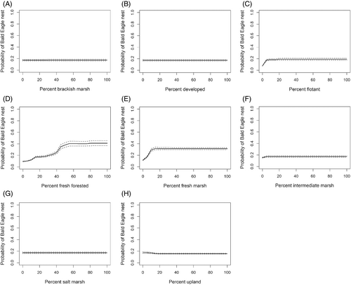
Fresh forested land cover explained the most variation in probability of Bald Eagle nest occurrence, followed by fresh marsh and flotant (Table 3). The remaining land cover types each explained <2% of the model variation. Probability of Bald Eagle nest occurrence was positively related to fresh forested, flotant, and fresh marsh, and (weakly) intermediate marsh land covers (Fig. 2). Meanwhile, Bald Eagle nest occurrence showed a weak negative response to upland land cover, and was neutral to brackish marsh, developed, and salt marsh land cover.
| Land Cover Class | Variable Importance (Mean ± SE) | Direction of Relationship |
|---|---|---|
| Brackish marsh | 0.02 ± 0.001 | Neutral |
| Developed | 0.08 ± 0.004 | Neutral |
| Flotant | 23.68 ± 0.07 | Positive |
| Fresh forested | 38.78 ± 0.04 | Positive |
| Fresh marsh | 34.29 ± 0.10 | Positive |
| Intermediate marsh | 1.82 ± 0.03 | Positive |
| Salt marsh | 0.00 ± 0.00 | Neutral |
| Upland | 1.34 ± 0.03 | Negative |
Restoration Scenarios
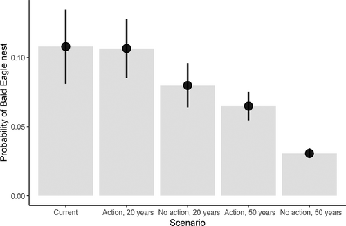
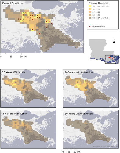
Across the Barataria Basin, the probability of Bald Eagle nest occurrence was similar under current conditions and the 20-year scenario with restoration action, with mean probabilities of occurrence of 0.11 ± 0.01 SE (Fig. 3). The no-action restoration scenario at 20 and 50 years, and the 50-year scenario with restoration action had reduced mean probabilities of Bald Eagle nest occurrence. At both 20 and 50 years, nest occurrence probability was higher with restoration action compared to the no-action scenario.
The spatial distribution of occurrence probability also changed in all future restoration scenarios. In the 20-year scenario with restoration action, predicted eagle nest locations spread northwest into the upper basin. Conversely, without action, suitable habitat availability in 20 years is predicted to shrink and shift slightly southwest within the upper-middle Barataria Basin (Fig. 4). In the 50-year scenario with restoration action, currently active areas became less suitable, and no new areas of the basin became suitable, whereas, without action, almost the entire basin became unsuitable (Fig. 4).
Discussion
Our research highlights that nesting Bald Eagles in the Barataria Bay region of southeastern Louisiana are associated almost exclusively with fresh forested, fresh marsh, and flotant land cover in the Barataria Basin. As such, this suggests that this iconic and charismatic bird serves as an indicator of TFFWs and freshwater emergent wetlands in coastal Louisiana. Yet, this reliance puts the Bald Eagle population at risk in the event of further freshwater wetland loss or degradation, as highlighted by the predicted reduction in nest occurrence probabilities in future scenarios without restoration action.
Bald Eagle nest occurrence was best explained by a positive association with fresh forested and fresh marsh habitat, whereas other land cover types had a weak negative or neutral relationship. This model also offered a compelling indication of significant stress and loss of this important habitat in the region. The Louisiana Coastal Restoration Plan (CPRA 2017) scenarios suggest an increase in freshwater marsh and associated Bald Eagle nest occurrence probability with restoration, as opposed to without. Our model indicates that Bald Eagles would nest at similar occurrence rates as in 2015 under the 20-year scenario with restoration action. However, the model predicts a decline in occurrence under all restoration scenarios after 50 years. This is likely because after 50 years, associated forested freshwater land cover is predicted to decline by 99.68% with restoration and almost 100% without. The benefit of the restoration action scenario is the potential for less rapid decline in Bald Eagles and their associated habitat compared to without restoration. Based on these findings, habitat suitability models can provide valuable management implications and a resource for restoration planning, prioritization, and decision-making by differentiating between restoration action, no action, and temporal effects.
On a localized and species-specific scale, our findings identify potential applications that may help restoration efforts better support species like the Bald Eagle. One of the central components of the 2017 Coastal Master Plan is river and sediment diversion projects, designed to reintroduce freshwater, nutrients, and sediments from the Mississippi River back into Barataria Basin. These projects are anticipated to maintain and restore freshwater habitats (Allison et al. 2012; Xu et al. 2019; Barra 2021), and wetland trees used by nesting Bald Eagles, like bald cypress, would likely benefit from river diversions through increased growth rates or increased recruitment (Day et al. 2007; Shaffer et al. 2016).
Despite the strong association of Bald Eagle nests with freshwater wetland habitats, our model does not recognize a positive response near the future outfall of the mid-Barataria Sediment Diversion. The outfall area is projected to be the Mid-Barataria Basin, an area that is losing land because of hydrologic alteration, sediment deprivation, subsidence, sea level rise, and saltwater intrusion. Within the Mid-Barataria Basin, modeled distributions of swamp forest and bottomland hardwood forest species are low (Visser et al. 2017). It is possible that without nesting trees nearby, otherwise suitable emergent marsh habitat may remain unoccupied. Large nesting trees may take decades to establish and grow after the construction of a river diversion, and indeed within the Caernarvon and Davis Pond freshwater diversion footprints in southeastern Louisiana where wetland building is occurring, Bald Eagles have not been noted to be nesting in these areas, which is over 20 years since diversion construction, although they are likely nesting nearby and foraging within the diversion outfalls (E. Johnson 2022, Audubon Delta, personal observation). To further benefit Bald Eagles beyond restoring hydrology through diversions and other means, strategically planting large trees or artificial platforms may provide important nesting substrates in otherwise suitable landscape relatively devoid of trees (Grubb 1980). Such management efforts would merit continued monitoring to measure feasibility and success. However, maintaining stands of forest adjacent to freshwater wetlands still appears to be the most important strategy to sustain nesting Bald Eagle populations in the Barataria Basin.
On a larger scale, our findings suggest that although the current restoration plan may effectively slow the decline in TFFWs and freshwater emergent wetlands, it is unable to prevent significant Bald Eagle nesting population loss in 50 years. Slowing upper estuary habitat loss is not without merit, however, and may provide more time for adaptive range shifts in species like the Bald Eagle which are able to do so. The stark trajectory of freshwater estuary loss in Louisiana also highlights an urgency to restore, maintain, and protect similar freshwater upper estuaries elsewhere in the Southeast United States that are less threatened by and/or more resilient to sea level rise. Hope for freshwater wetland conservation support may partially lie in promoting Bald Eagle conservation. As a charismatic national bird of the United States, the Bald Eagle is widely popular (Schuetz & Johnston 2019) and historically has received strong bipartisan support in recovery and conservation (Petersen 1999; Robinson 2019). Its longstanding admiration and public interest may help garner increasingly broad support for wetland conservation in the Southeast and greater United States.
Acknowledgments
This project was funded by the Walton Family Foundation. The authors appreciate discussions with and insights from the Restore the Mississippi River Delta Campaign Science Team, David Lindquist and Elizabeth Jarrell, with the Coastal Protection and Restoration Authority Modeling Decision Team, and Elizabeth Robinson, with the Louisiana State University AgCenter. Aerial survey data were provided by the Louisiana Department of Wildlife and Fisheries (LDWF), and the authors are grateful for Michael Seymour and Amity Bass for sharing the LDWF Bald Eagle nest dataset and providing insights into their data collection protocols.


